Explorations in Space and Society No marzo 2010 ISSN Maps: Beyond the Artifact.
|
|
|
- Rosa Pace
- 9 anni fa
- Visualizzazioni
Transcript

1 Explorations in Space and Society No marzo 2010 ISSN Maps: Beyond the Artifact 15Lo s uaderno Q

, ø210 cm, Cloth.")
2 Random map-costume popolare 1.0 (2001), ø210 cm, Cloth.
,")
3 Table of contents Mappe: oltre l artefatto Guest artist: Stefano Boccalini Editorial / Editoriale Rob Kitchin Post-representational cartography / Cartografia post-rappresentativa Jeremy Crampton Cartography and the calculation of territory Peter Turchi New tools, new vision: Telling the next story Vincent Miller Mapping and the colonization of the lifeworld Adriano Cancellieri Non so(no) dove sono. Spazi in-formazione e mappe performative Adelina von Fürstenberg Economia politica/geografie umane. Intervista con Stefano Boccalini Nasser Abhourame and Laura Ribeiro Re-weaving fragmented space-time. Notes from a mapping project in Palestine / Ritessere uno spaziotempo frammentato. Note da un progetto di mappatura in Palestina Ed Wall Mapping Informality Andrea Mubi Brighenti Mapping as dreaming Davide Papotti La mappa mentale del boscaiolo. Note su un illuminazione cartografica di Cesare Zavattini Iacopo Zetti Pieghe dello spazio urbano. Una mappa di luoghi cancellati a Budapest Cristina Mattiucci Il paesaggio senza mappa 3

4 EDITORIAL When we edited our first issue of lo Squaderno on mapping (no. 7, March 2008) we had the sense that mapping was still or was becoming again a hot topic. We grew up in Italy in the 1990s and at that time independent mapping projects formed an essential component of social and political activism: maps of squat evictions, maps of weapon industry and global money flows, corporeal geographies and other unknown pleasures were produced and spread in the radical fringe. Concurrently, the most intellectual among our friends were (re-)discovering Situationist psychogeographical mapping, together with a number of playful and unconventional uses of maps. The idea that everyone could become a map maker had a liberating potential on imagination. While cartography was still criticised as a tool of power the lines of the map determine relations of visibility and power, including some trajectories and excluding others there was also a concurrent attempt at actively appropriating this tool. However, just a few years later, the advent of cartography 2.0 and interactive online mapping systems made available on mass scale has significantly transformed the meaning and the scope, not only of self-made cartography (certainly put under strain by the fact that playfulness has turned into a key term of the new spirit of capitalism), but of a large array of cartographic practices. The map as stabilised artefact gives way to the process of visualising a dynamic and evolving artefact. In a recent essay, Tim Ingold identifies two different ways of mapping he calls mapping along and mapping across : on the one hand, mapping while following a path (along), on the other mapping by establishing distances and relations between points (across). To our mind, Ingold s reflection constitutes a fruitful starting point to rethink the content of maps beyond the artefact. Indeed, mapping is at the crossroad of different models of movement, between different ways of using space, as well as different implied visions of the world and different potentialities of transforming it. In this issue we have tackled a number of questions that follow from these new mapping practices. The first part is theoretical and hosts contributions by Rob Kitchin and Jeremy Crampton who are among the most important theorists of cartography today respectively on the post-representational turn in cartography and the relationships between mapping and calculation. More humanist in orientation, Peter Turchi s, Vincent Miller s and Adriano Cancellieri s pieces are located at the intersection between cartography, phenomenology and the human need for spaces of narratives. After an interview by Adelina von Fürstenberg with our guest artist Stefano Boccalini on his cartographic artworks, a more practical, case-based section follows. Nasser Abhourame and Laura Ribeiro present their mapping project in Palestine, subtly problematising the ways in which cartography can be deployed to reweave fragmented social spaces and their memories. Ed Wall documents his recent project Mapping Informality (co-authored with Sam Johnston), which draws from Laguerre s notion of informal city to map informal interaction in South London. Mubi suggests an excursus through Canadian hunting tribes to take notice of the similarities between mapping and dreaming, while Davide Papotti tells an interesting anecdote about Zavattini and how he discovered aspects of his own native town, Luzzara (Emilia-Romagna, Italy), through his photographer friend Paul Strand and the latter s ingenious use of a rather conventional map. Then, Iacopo Zetti proposes an excursion among Budapest s deleted places : these places, he argues, could only exists until they could slip through the sieve of large-scale urban planning, but have been swept away by the advent of more fine-grained capitalist land use. In conclusion, Cristina Mattiucci returns on the limits of mapping in relation to the nature of lived landscapes. A.M.B., C.M.
discovering Situationist psychogeographical mapping, together with a number of playful and unconventional uses of maps.")
5 EDITORIALE Quando pubblicammo il primo numero de lo Squaderno sulle mappe (n. 7) avevamo la sensazione che esse fossero ancora o di nuovo un tema caldo. Nell Italia negli anni Novanta i progetti di mappatura indipendente erano stati una componente essenziale dell attivismo sociale e politico: mappe di sgomberi, di industrie militari e flussi globali di capitale, geografie corporee ed altri piaceri sconosciuti circolavano nell area radicale. Contemporaneamente, i più intellettuali tra i nostri amici stavano (ri-)scoprendo le mappe psicogeografiche situazioniste, assieme ad una quantità di usi gioiosi e non convenzionali delle carte geografiche: l idea che ciascuno potesse costruire la propria mappa stava liberando un grande potenziale di immaginazione. Mentre la cartografia venniva ancora criticata come uno strumento del potere le linee della mappa determinano relazioni di visibilità e potere, includendo alcune traiettorie ed escludendone altre c era anche una contemporanea tensione a trasformare attivamente questi strumenti. Solo pochi anni più tardi, l avvento della cartografia 2.0 ed i sistemi interattivi di mappe online divenuti di massa hanno significativamente trasformato il significato e lo scopo non solo delle cartografie autoprodotte (sicuramente messe a dura prova dal fatto che la giocosità si è trasformata nel frattempo in un termine chiave del nuovo spirito del capitalismo) ma di una più ampia serie di pratiche cartografiche. La mappa come artefatto stabilizzato cede il passo al processo di visualizzazione di un artefatto dinamico e in continua evoluzione. In un saggio recente Tim Ingold individua due modi diversi di mappatura che chiama mapping along e mapping across: da un lato mappare seguendo un percorso (along), dall altro mappare stabilendo distanze e relazioni tra punti (across). La riflessione di Ingold ci sembra costituire un punto di partenza fecondo per ripensare il contenuto delle mappe al di là dell artefatto. La mappatura infatti si trova al crocevia di diversi modelli di movimento, di diversi modi di usare lo spazio, così come di diverse e implicite visioni del mondo e potenzialità di trasformarlo. In questo numero abbiamo affrontato una serie di questioni che derivano da queste nuove pratiche del mappare. La prima parte è teorica e ospita contributi di Rob Kitchin e Jeremy Crampton che sono oggi tra i più importanti teorici della cartografia che vertono rispettivamente sulla cartografia post-rappresentativa e sulle relazioni tra cartografia e calcolo. Con un orientamento più umanista, i contributi di Peter Turchi, Vincent Miller e Adriano Cancellieri si collocano all incrocio tra la cartografia, la fenomenologia e esplorano l umano bisogno di spazi di narrazioni. Dopo un intervista di Adelina von Fürstenberg con l artista ospite, Stefano Boccalini, sulle sue opere cartografiche, segue una sezione di interventi che si basano su esperienze e casi pratici. Nasser Abhourame e Laura Ribeiro presentano il loro progetto di mappatura in Palestina, problematizzando sottilmente i modi in cui la cartografia può contribuire a ritessere spazi sociali frammentati e le loro memorie. Ed Wall descrive il progetto suo e di Sam Johnston Mapping Informality, che muove dalla nozione Laguerre di città informale per mappare l interazione informale nei quartieri di Londra sud. Mubi propone un excursus attraverso le tribù di caccia canadese per osservare le somiglianze tra mappare e sognare, mentre Davide Papotti racconta un aneddoto interessante su Zavattini e su come questi abbia scoperto alcuni caratteri della sua città natale, Luzzara (in Emilia-Romagna), attraverso il suo amico fotografo Paul Strand ed l uso ingegnoso che quest ultimo faceva di una mappa piuttosto convenzionale. Quindi, Iacopo Zetti propone un escursione tra i luoghi cancellati di Budapest: questi luoghi, egli sostiene, sono potuti esistere solo fino a quando sono riusciti a scivolare tra le maglie della pianificazione urbana, ma sono stati spazzati via daun uso del suolo capitalista di grana estremamente più fine. In conclusione, Cristina Mattiucci ritorna sui limiti della mappa in relazione alla natura dei paesaggi vissuti. A.M.B., C.M. 5
scoprendo le mappe psicogeografiche situazioniste, assieme ad una quantità di usi gioiosi e non convenzionali delle carte")

6 Random map-mushroom community (2001), variable dimensions, painted wood, earth, mushrooms (detail)

7 Post-representational cartography Rob Kitchin Over the past decade there has been a move amongst critical cartographers to rethink maps from a post-representational perspective that is, a vantage point that does not privilege representational modes of thinking (wherein maps are assumed to be mirrors of the world) and automatically presumes the ontological security of a map as a map, but rather rethinks and destabilises such notions 1. This new theorisation extends beyond the earlier critiques of Brian Harley (1989) that argued maps were social constructions. For Harley a map still conveyed the truth of a landscape, albeit its message was bound within the ideological frame of its creator. He thus advocated a strategy of identifying the politics of representation within maps in order to circumnavigate them (to reveal the truth lurking underneath), with the ontology of cartographic practice remaining unquestioned. As Jeremy Crampton (2003: 90) has argued, Harley s approach provided an epistemological avenue into the map, but still left open the question of the ontology of the map. Recent work has started to probe cartography s ontology and in this short paper, I detail in brief five such attempts to rethink the ontology of maps to provide a new perspective on how they are conceived, made and used. John Pickles (2004) conceives of maps as inscriptions as opposed to representations or constructions. His work focuses on the work that maps do, how they act to shape our understanding of the world, and how they code that world (p. 12). As such his aim is to chart the practices, institutions and discourses of maps and their social roles within historical, social and political contexts using a poststructural framework that understands maps as complex, multivocal and contested, and which rejects the notion of some truth that can be uncovered by exposing ideological intent. Pickles argues that cartography does not simply describe and explain the world; it is part of the interplay between the world and ourselves; it describes the world as exposed to our method of questioning. Pickles thus sees maps as unstable and complex texts; texts that are not authored or read in simple ways. Rather than a determinate reading of the power of maps that seeks to uncover in a literal sense the authorial and ideological intent of a map (who made the map and for what purpose), Pickles expresses caution in fixing responsibility in such a manner, recognising the multiple, institutional and contextual nature of mapping. Similarly, the power of maps is diffuse, reliant on actors embedded in contexts to mobilise their potential effects: All texts are embedded within chains of signification: meaning is dialogic, polyphonic and multivocal open to, and demanding of us, a process of ceaseless contextualization and recontextualization (Pickles 2004: 174). His 1 This paper draws significantly from Kitchin and Dodge (2007) and Kitchin et al. (2009). Prof. Rob Kitchin is Director of the National Institute of Regional and Spatial Analysis (NIRSA) at the National University of Ireland, Maynooth, and Chair of the Management Board of the Irish Social Sciences Platform (ISSP). To date he has published 17 books, edited the 12 volume International Encyclopedia of Human Geography, and written over 100 articles and book chapters. Until recently he was the managing editor of Social and Cultural Geography, and is presently an editor of Progress in Human Geography and Dialogues in Human Geography. He s a regular contributor to the blog Ireland After NAMA. rob.kitchin@nuim.ie 7

8 approach is to produce denaturalised histories consisting of genealogies of how cartography has been naturalised and institutionalised across space and time as particular forms of scientific practices and knowledge. Wood and Fels (2008) similarly argue that maps do not simply represent the world, they produce the world. They argue that maps produce the world by making propositions which are placed in the space of the map. Maps achieve their work by exclaiming such propositions and Wood and Fels define this process as one of posting information on map. Posting is the means by which an attribute is recognised as valid (e.g., some class of the natural world) and is spatialised. It is the means by which the nature of maps (this is category) and the nature of maps (there sign) conjoin to create a unified spatial ontology (this is there). However, the map extends beyond spatial ontology by enabling higher order propositions (this is there and therefore it is also; Wood and Fels 2008) to link things in places into a relational grid. Wood and Fels argue that the power of this spatial propositional framework is affirmed through its call to authority by being an objective reference object that is prescriptive not descriptive. So the map produces and reaffirms territory rather than just describing it. Because maps are prescriptive systems of propositions, Wood and Fels contend that map creation should not solely be about presenting information through attractive spatial representations as advocated by the majority of cartographic textbooks. Instead they suggest map design should be about the construction of meaning as a basis for action (p. xx). James Corner (1999) argues that cartographic theory has been hampered by a pre-occupation to view maps in terms of what they represent and mean rather than what they do. Drawing on poststructural theory, he problematises the conception of maps as representations that are separate and proceeding from territory. Following Baudrillard, he argues that a territory does not precede a map, but that space becomes territory through bounding practices that include mapping. Moreover, given that places are planned and built on the basis of maps, so that space is itself a representation of the map, the differentiation between the real and the representation is no longer meaningful (p. 222). Maps and territories are coconstructed. Space is constituted through mapping practices, amongst many others, so that maps are not a reflection of the world, but a re-creation of it; mapping activates territory. Corner thus develops an understanding of maps as unfolding potential; as conduits of possibilities; as the sites of imagination and action in the world. For him maps remake territory over and over again, each time with new and diverse consequences (p. 213). He explains that maps engender such re-territorialisations because they are doubly projective: they both capture elements from the world and also project back a variety of effects through their use. He thus suggests that cartographic research and practice needs to focus on mapping actions and mapping effects and not solely on the construction of maps per se. Del Casino and Hanna (2005) draw on the ideas of Deleuze and Guattari and Judith Butler, to argue that maps are in a constant state of becoming; that they are mobile subjects whose meaning emerges through socio-spatial practices of use that mutate with context and is contested and intertextual. For them the map is not fixed at the moment of initial construction, but is in constant modification where each encounter with the map produces new meanings and engagements with the world. Del Casino and Hanna (2005: 36) state that [m]aps are both representations and practices simultaneously. Neither is fully inscribed with meaning as representations nor fully acted out as practices. Maps and spaces coproduce each other through spatial practices to create what they term map spaces, wherein it is impossible to disentangle fully how the map does work in the world from how the world shapes how the map is performed they are co-constitutive. They illustrate their argument

9 by an examination of how visitors produce the historic town of Fredericksburg in Virginia, by deploying tourist maps. They show that the real is read back into the map-making it more legible. Tourists are both consumers and producers of the map; authors and readers. Meaning emerges through action and action is shaped by meaning in a complex, recursive and intertextual performativity. The tourist map is never complete, but is always mobile; always being produced by tourists and producing the space. Likewise, along with Martin Dodge (2007), I have argued that map theory needs to shift from seeking to understand the nature of maps (how maps are) to examining the practices of mapping (how maps become). Maps we argue are not ontologically secure representations but rather a set of unfolding practices: [m]aps are of-the-moment, brought into being through practices (embodied, social, technical), always re-made every time they are engaged with; mapping is a process of constant re-territorialisation. As such, maps are transitory and fleeting, being contingent, relational and context-dependent. Maps are practices they are always mappings; spatial practices enacted to solve relational problems (e.g., how best to create a spatial representation, how to understand a spatial distribution, how to get between A and B, and so on) (Kitchin and Dodge 2007: 5). From this perspective, what is traditionally understood as a map is not unconditionally a map; it is rather a set of points, lines and colours that is brought into being as a map through mapping practices (an inscription in a constant state of re-inscription). As such, the map is (re)made every time mapping practices, such as recognising, interpreting, translating and communicating, are applied to the pattern of ink or digital bits. These mapping practices give the map the semblance of ontological security because they are learned and constantly reaffirmed. Maps do not then emerge in the same way for all individuals. Rather they emerge in contexts and through a mix of creative, reflexive, playful, tactile and habitual practices; affected by the knowledge, experience and skill of the individual to perform mappings and apply them in the world. New ways of thinking about cartography opens up the debate on the ontology of maps, creating new post-representational and processual modes of understanding These new ways of thinking about cartography opens up the debate on the ontology of maps, creating new post-representational and processual modes of understanding. In so doing it allows cartography to be reconceived in such a way that the technical and ideological aspects of mapping can be considered and practised together. Moreover it opens up new epistemological questions focused on the broad practices of mapping, rather than simply map-making or map-using or the nature of maps. Instead, attention is given to how maps come into being in diverse ways, for diverse purposes, shaped by diverse contexts. Cartografia post-rappresentativa Negli ultimi dieci anni all interno della cartografia critica è nato un movimento volto a un ripensamento della mappa secondo una prospettiva post-rappresentativa. Si è trattato di adottare un punto di vista che non privilegi modi di pensare mimetici, i quali assumono cioè la certezza ontologica della mappa come specchio del mondo, ma che al contrario destabilizzi queste nozioni. Questa nuova teorizzazione si spinge oltre la posizione di Brian Harley (1989), secondo il quale le mappe sono costruzioni sociali. Per Harley in fondo la mappa conteneva ancora la verità di un paesaggio, sebbene il suo 9
, I have argued that map theory needs to shift from seeking to understand the nature of maps (how maps are) to examining the practices of mapping (how maps")
10 messaggio fosse contenuto all interno dei riferimenti ideologici del suo creatore. Di conseguenza, egli proponeva una strategia per identificare le politiche di rappresentazione interne alle mappe al fine di circumnavigarle (per svelarle dal basso) lasciando però inesplorata l ontologia della pratica cartografica. Come ha sottolineato Jeremy Crampton (2003: 90), l approccio di Harley ha determinato un allargamento epistemologico nella mappa, ma lascia ancora aperta la questione dell ontologia della mappa. Lavori più recenti hanno iniziato ad approfondire proprio l ontologia della cartografia. In queste note descriverò in breve cinque di queste ipotesi per ripensare l ontologia delle mappe, al fine di definire una nuova prospettiva riguardo a come esse sono concepite, costruite ed usate. John Pickles (2004) concepisce le mappe come inscrizioni, piuttosto che come rappresentazioni o costruzioni. Il suo lavoro si concentra sul lavoro che le mappe fanno, su come esse operano nel dare forma alla nostra comprensione del mondo e su come esse codificano questo mondo (p. 12). Uno dei suoi obiettivi è dunque quello di registrare pratiche, istituzioni e discorsi delle mappe e dei loro ruoli sociali all interno dei contesti storici, sociali e politici, usando un approccio poststrutturalista che vede le mappe come oggetti complessi e non univoci, e che rifiuta la nozione di una certa verità data semplicemente dalla dichiarazione dell intento ideologico. Pickles afferma che la cartografia non descrive semplicemente il mondo; essa è parte dell interazione tra il mondo e noi stessi, pertanto descrive il mondo così come si manifesta al nostro modo di indagarlo. Pickles interpreta dunque le mappe come testi instabili e complessi, testi che non sono scritti o letti in modo semplice. Piuttosto che una determinata lettura del potere delle mappe che cerca di rivelarne in senso letterale l intento autoriale e ideologico (chi fa la mappa e per quale proposito), Pickles esprime una certa cautela nell individuare e fissare la responsabilità del cartografo, riconoscendo la natura multipla, istituzionale e contestuale del mappare. Analogamente, il potere delle mappe è diffuso, detenuto da attori situati in contesti locali. Tutti i testi sono radicati all interno di un sistema di significazione: il significato è dialogico, polifonico e multivocale aperto, ed esigente, un processo incessante di contestualizzazione e ricontestualizzazione (Pickles 2004: 174). Il suo approccio produce storie snaturate fatte di genealogie di come la cartografia è stata introdotta ed istituzionalizzata attraverso spazio e tempo come particolari forme di pratiche e conoscenza scientifica. Analogamente anche Wood e Fels (2008) affermano che le mappe non rappresentano semplicemente il mondo: esse producono il mondo, costruendo proposizioni che sono situate nello spazio della mappa. Le mappe svolgono il proprio lavoro esclamando delle proposizioni e Wood e Fels definiscono questo processo come postare informazioni sulla mappa. Postare è l atto per mezzo del quale un attributo è riconosciuto come valido (per esempio alcune classi del mondo naturale) e viene spazializzato. è il mezzo con cui la natura delle mappe ( questo è categorico) e la natura delle mappe ( qui segnico) si congiungono per creare un ontologia spaziale unificata ( questo è qui ). Comunque, la mappa si estende oltre l ontologia spaziale stabilendo un ordine superiore tra le proposizioni ( questo è qui e quindi è anche ; Wood e Fels 2008) per connettere le cose ai luoghi all interno di una griglia relazionale. Per Wood e Fels il potere di questa struttura spaziale proposizionale si afferma attraverso il richiamo all autorità essendo un oggetto di riferimento oggettivo che è prescrittivo, non descrittivo. Dunque le mappe producono e riaffermano il territorio piuttosto che semplicemente descriverlo. Dato che le mappe sono sistemi prescrittivi di proposizioni, Wood e Fels asseriscono che la creazione della mappa non dovrebbe riguardare solamente la presentazione di informazioni attraverso rappresentazioni spaziali attraenti come invece è indicato nella maggior parte dei testi di cartografia. Fare la mappa dovrebbe essere la costruzione di un significato come base per l azione. James Corner (1999) scrive che la teoria cartografica è stata bloccata dalla preoccupazione di vedere le mappe nei termini di ciò che esse rappresentano e vogliono dire, piuttosto che di ciò che esse fanno. Costruendo una teoria poststrutturalista, Corner problematizza la concezione delle mappe come rappresentazioni che sono separate e derivano dal territorio. Secondo Baudrillard il territorio non precede una mappa, ma lo spazio diventa territorio per mezzo di pratiche che determinano delimitazioni, tra le quali anche il fare la mappa. Inoltre, dato che i luoghi sono pianificati e costruiti sulla base delle mappe, lo spazio in sé è una rappresentazione della mappa, la differenziazione tra il reale e la rappresentazione non è molto significativa (p. 222). Mappe e territori sono co-costruiti. Lo spazio è costituito tra l altro da pratiche di mappatura, per cui la mappa non è un riflesso del mondo, ma una sua ri-creazione; il map-
, l approccio di Harley ha determinato un allargamento epistemologico nella mappa, ma lascia ancora aperta la questione dell ontologia della mappa.")
11 pare attiva il territorio. Corner inoltre sviluppa una concezione delle mappe come potenziale aperto; come volano di possibilità; come siti dell immaginazione e dell azione nel mondo. Per lui le mappe ricostruiscono il territorio più e più volte, ogni volta con nuove e diverse conseguenze (p.213). Spiega che le mappe generano questa ri-territorializzazione perché sono doppiamente proiettive: esse non solo catturano gli elementi dal mondo, ma proiettano sul mondo una varietà di effetti attraverso il loro uso. Egli perciò suggerisce che la ricerca e la pratica cartografica hanno bisogno di riflettere sulle azioni e sugli effetti del mappare e non solo sulla costruzione delle mappe in sé. Del Casino e Hanna (2005) muovono dalle idee di Deleuze e Guattari e Judith Butler, per sostenere che le mappe sono in divenire continuo, soggetti mobili il cui significato emerge da pratiche sociospaziali d uso che mutano con il contesto. La mappa non è fissa al momento della iniziale costruzione, è in costante modificazione laddove ciascun incontro con la mappa produce nuovi significati e relazioni con il mondo. Del Casino e Hanna (2005: 36) affermano che le mappe sono sia rappresentazioni che pratiche... simultaneamente. Esse non si caratterizzano esclusivamente per il loro significato rappresentativo, né si esprimono totalmente come pratiche. Mappe e spazi sono le une e gli altri co-prodotti attraverso pratiche spaziali che creano quello che loro chiamano spazio mappa, in cui è impossibile distinguere totalmente il modo in cui la mappa opera nel mondo dal modo in cui il mondo determina la forma della mappa essi sono co-costituiti. Del Casino e Hanna illustrano la loro tesi attraverso l analisi di come i visitatori producono la città storica di Fredericksburg in Virgina con l uso delle mappe turistiche. Mostrano come il reale è letto e restituito dalla mappa, reso più leggibile. I turisti sono sia consumatori che produttori di mappe; autori e lettori. Il significato emerge attraverso la forma e l azione prende forma attraverso il significato che si rappresenta con modalità complesse, ricorsive e intertestuali. La mappa turistica non è mai completa ma è sempre mobile; viene sempre prodotta dai turisti e produce lo spazio. Allo stesso modo, insieme a Martin Dodge (2007), ho sostenuto che la teoria cartogrfica deve passare dalla ricerca della comprensione della natura delle mappe (cioè come sono) all esplorazione delle pratiche di mappatura (cioè come le mappe si realizzano). Le mappe non sono rappresentazioni ontologicamente sicure, ma piuttosto un sistema di pratiche aperte: le mappe sono del momento, determinate nel loro essere attraverso le pratiche (incorporate, sociali e tecniche), sempre ri-costruite ogni qualvolta esse accadono; il mappare è un processo di costante riterritorializzazione. Come tali, le mappe sono transitorie ed effimere, essendo contingenti, relazionali e dipendenti dal contesto. Le mappe sono pratiche, sono sempre mappature; pratiche spaziali definite mediante la loro rappresentazione per risolvere problemi relazionali (per esempio, come meglio creare una rappresentazione spaziale, come comprendere una distribuzione spaziale, come muoversi tra A e B, e così via (Kitchin e Dodge 2007: 5). Da questa prospettiva, ciò che è tradizionalmente inteso come mappa non è incondizionatamente una mappa; è piuttosto un sistema di punti, linee e colori che è portato a costituire una mappa attraverso pratiche di mappatura (un iscrizione in costante stato di re-iscrizione). Come tale, la mappa è (ri)fatta ogni volta attraverso le pratiche del riconoscere, interpretare, tradurre e comunicare, applicate al modello di inchiostro o di bit digitali. Queste pratiche danno alla mappa la parvenza di una sicurezza ontologica perché sono apprese e costantemente ribadite. Le mappe non emergono poi nello stesso modo per tutti gli individui. Piuttosto esse emergono in contesti ed attraverso un mix di pratiche creative, riflessive, ludiche, tattili ed abituali; determinate dalla conoscenza, dall esperienza e dalla capacità dell individuo di mappare praticamente. Questi nuovi modi di pensare alla cartografia aprono il dibattito sull ontologia della mappa, creando nuovi modi di comprensione, post-rappresentativi e processuali. Si aprono nuove questioni epistemologiche, incentrate sulle pratiche di mappatura in senso ampio, piuttosto che semplicemente sul fare-lamappa o sull usare-la-mappa o sulla natura delle mappe. Invece, l attenzione è rivolta al modo in cui le mappe nascono in diversi modi, per scopi diversi, e prendono forma in funzione dei diversi contesti. 11

 Mappings, London, Reaktion Books. Crampton, J. (2003) The Po")
12 Random map-costume popolare 2.0 (2001), 27x40 cm, Lambda print on aluminium References Corner, J. (1999) The agency of mapping: speculation, critique and invention, in D. Cosgrove (ed.) Mappings, London, Reaktion Books. Crampton, J. (2003) The Political Mapping of Cyberspace, Edinburgh: Edinburgh University Press. Del Casino, V.J. and Hanna, S.P. (2005) Beyond the binaries : A methodological intervention for interrogating maps as representational practices, ACME: An International E-Journal for Critical Geographies, 4(1): Harley, J.B. (1989) Deconstructing the map, Cartographica, 26(2): Kitchin, R. and Dodge, M. (2007) Rethinking maps, Progress in Human Geography, 31(3): Kitchin, R., Perkins, C. and Dodge, M. (2009) Thinking about maps. In Dodge, M., Kitchin, R. and Perkins, C. (Eds) Rethinking Maps. Routledge, London. Pickles, J. (2004) A History of Spaces: Cartographic Reason, Mapping and the Geo-Coded World, London: Routledge. Wood, D. and Fels, J. (2008) The Natures of Maps: Cartographic Constructions of the Natural World, Chicago: University of Chicago Press.

13 Cartography and the calculation of territory Jeremy W. Crampton In this short essay I would like to consider the calculative relationships of cartography and territory. By this, I mean something more specific than the idea of maps producing territory the power of maps but of how and with what effects specifically calculative cartographic rationalities operate. We can begin by clarifying some of these terms. The production of territory: both the material production of a landscape, and of its production in discourse. Sometimes we might write as if only the latter case exists but there are material effects as well. An obvious case of the latter is how borders are drawn in racialized landscapes. Thus identity is intrinsically related to the process and/or practice of the production of territory. Territory: a difficult and multifaceted term, perhaps not reducible to a single concept, but including bounded and unbounded areas, areas over which humans and animals may roam and identify with, and these days even vertical spaces (Sloterdijk, 2009). Authors also note the parallels between territory and terror (Elden, 2009) and new politics of space. Calculation: taken up by an increasing number of scholars over the last few years, both from a more general perspective of the problem of number (and space) and the more specific relationship between mapping and territory (Elden, 2007; Hannah, 2009). Elden notes that mathematics and its relation to philosophy is making something of a return in human geography, and yet not as a straightforward rerun of the quantitative revolution (Elden, 2008, p. 2645). Calculation is a specific way of knowing and knowledge, where to be, is to be calculable. Rationality: the mode(s) of reason by which any of this takes place. How does this apply to maps and cartography? Several years ago the French philosopher Jean Baudrillard suggested that the map precedes the territory (Baudrillard, 1994). We might gloss this by saying that maps frame our understanding of the world. There s a German word here that I ve used in the past: Befindlichkeit. This is a Heideggerian neologism based on the German Wie befinden Sie sich? or How are you (literally How do you find yourself ). This is sometimes translated as attunement or state of mind but it can mean finding one s place in the world that is, mapping (see Crampton, 2004, pp ). If we draw these threads together territory, cartography, calculation then I think we are in an appropriate place to better understand territory. Jeremy W. Crampton is Associate Professor of Geography & Graduate Director at the Department of Geosciences, Georgia State University. He is the editor of Cartographica. Research interests include the politics of identity, critical approaches to cartography and GIS, biopolitics and race and the work of Michel Foucault. His latest book is Mapping: A Critical Introduction to Cartography and GIS (2010). jcrampton@gsu.edu 13

14 The ontology of territory The beauty of the phrase finding one s place in the world (or more cumbersomely always already finding one s place among the world) is that it opens up the investigation of ontology. Ontology is the study of being. How do we have our being, and how is being related to territory? Cartography is important here because being-as-identity maps on to territory in specific ways. For example, following World War I the victorious allies struggled to reformulate European territories at the Paris Peace Conference. Whereas previously a strategic territorial solution had been used placing boundaries along defensible borders The primary rationality today: the calculative. The calculation of space, what we might identify as the politics of calculation, is a primary way in which populations and subjects are constituted the allies adopted a radical new approach. Now it became a question of who you were, a question of being. In fact, it was a dispute about the identity of people who lived on the Istrian peninsula near Trieste between Italy and Yugoslavia that nearly brought about the collapse of the conference when the Italian delegation walked out. Were these people Italian or Yugoslav or mixed? If mixed, who predominated? And finally, could you draw boundaries between them? It turned out that you could, but there were many boundaries (Figure 1). As this example shows, often the question of being, of who are you, becomes a question in cartography of what are you? What are you, what characteristics and properties do you have? What languages do you speak? What is your religion? As fieldworkers reported during the Conference however, often responses were not in terms of national identity at all. I m a Catholic who lives around these parts they would say when asked their preferred nationality. Cartography and GIS have a long history of mapping properties, especially those that can be measured and located. This example hints that the state is only problematically characterized as a bounded territory within which it has a legitimate monopoly of power. What is primary is not the boundary, but a particular rationality of territory, around which the boundary can then be wrapped. The war on terror is another example (Amoore, 2009). David Frum placed the term axis of evil in George Bush s 2002 State of the Union address, Condoleeza Rice spoke of outposts of tyranny and Thomas Barnett of the US Department of Defense created the Pentagon s new map by spatially identifying a functioning core and a non-integrating gap (Barnett, 2004). All of these are ways of appropriating territory by denying self-sovereignty or by asserting US sovereignty outside its national borders. The rationality, as expressed in the map, calculates the territory. The primary rationality today: the calculative. The calculation of space, what we might identify as the politics of calculation, is a primary way in which populations and subjects are constituted. States govern today by calculation of for example demographic trends of their populations, and the cartographic calculations of racialised territories (Crampton, 2010). As a range of authors have pointed out the rise of the modern calculating state and stateistics derive from calculable orders (Hacking, 1990; Shaw & Miles, 1979). Cartographically, this is taken up as the way space is geo-coded through mapping and the rise of thematic mapping to know, control and govern territories (Rose-Redwood, 2008; Steinberg, 2009). At issue here is how our current geospatial technologies of GIS and digital mapping are calculating space. The basic model of the world in GIScience texts is: points, lines, areas, surfaces and volumes. This scheme draws on ways of understanding space that were


15 formally put together (but far from invented) by people such as J. K. Wright (Wright, 1944). In this Cartesian scheme of res extensa points make up lines, lines make areas, and surfaces make volumes. Consequently territories are extended, enclosed areas. More recently we see the calculative in GIScience ontologies. GIScience ontology takes as its focus how objects and things are spatially constituted, e.g., what counts as an eminence or high-ish segment of the terrain (Sinha & Mark, Forthcoming; Smith & Mark, 2003). It typically draws on the Aristotelian tradition of ontology as objects with properties (i.e., predicate or substance ontology). GISs are structured as object-oriented architectures of formal ontologies (Leszczynski, 2009, p. 357) necessitating therefore a materialist examination of how GIS knowledges are structured as objects with properties. Given that GIScience ontologies arose in attempts to create artificial intelligence and that this project remains unrealized at best (and doomed to failure according to the philosopher Hubert Dreyfus [1992]) we might wonder what this means for GIScience. If this kind of ontology which is actually about entities or beings rather than the Heideggerian tradition that ontology is rather about being is working for formally representing the natural world (those things for which their being is not a question) would it work for the human world? Since human beings are not objects with properties, I have my doubts. Figure 1 15
.")
16 Conclusion What is characteristic of the work cited here is how much of it is committed to a project of historical critique. These critiques reveal the degree to which territory is not solely a state-centered phenomenon, but a historically and geographically specific form of political organization and political thought (Brenner & Elden, 2009, p. 355). Although we now know a great deal about the productive practices of cartography and maps it seems to me that this project is more important than ever. References Amoore, L. (2009). Algorithmic war: Everyday geographies of the war on terror. Antipode, 41(1), Barnett, T. P. M. (2004). The Pentagon s new map: war and peace in the twenty-first century. New York: G.P. Putnam s Sons. Baudrillard, J. (1994). Simulacra and simulation. Ann Arbor: University of Michigan Press. Brenner, N., & Elden, S. (2009). Henri Lefebvre on State, Space, and Territory. International Political Sociology, 3, Crampton, J. W. (2004). The Political Mapping of Cyberspace. Chicago: University of Chicago Press. Crampton, J. W. (2010). Mapping: A Critical Introduction to Cartography and GIS. Oxford and New York: Wiley- Blackwell. Dreyfus, H. L. (1992). What computers still can t do: a critique of artificial reason. Cambridge, Mass.: MIT Press. Elden, S. (2007). Governmentality, Calculation, Territory. Environment & Planning D: Society and Space, 25(3), Elden, S. (2008). Dialectics and the measure of the world. Environment and Planning A, 40(11), Elden, S. (2009). Terror and territory. The spatial extent of sovereignty. Minneapolis: University of Minnesota Press. Hacking, I. (1990). The Taming of Chance. Cambridge, UK and New York: Cambridge University Press. Hannah, M. G. (2009). Calculable territory and the West German census boycott movements of the 1980s. Political Geography, 28(1), Leszczynski, A. (2009). Quantitative Limits to Qualitative Discussions: GIS, its Critics, and the Philosophical Divide. The Professional Geographer, 61(3), Rose-Redwood, R. S. (2008). Sixth Avenue is now a memory : Regimes of spatial inscription and the performative limits of the official city-text. Political Geography, 27(8), Shaw, M., & Miles, I. (1979). The Social Roots of Statistical Knowledge. In J. Irvine, I. Miles & J. Evans (Eds.), Demystifying Social Statistics. London: Pluto Press. Sinha, G., & Mark, D. M. (Forthcoming). Extraction and Database Modeling of Topographic Eminence. Cartographica. Sloterdijk, P. (2009). Airquakes. Environment and Planning D: Society and Space, 27(1), Smith, B., & Mark, D. M. (2003). Do mountains exist? Towards an ontology of landforms. Environment and Planning B: Planning and Design, 30(3), Steinberg, P. E. (2009). Sovereignty, territory, and the mapping of mobility: A view from the outside. Annals of the Association of American Geographers, 99(3), Wright, J. K. (1944). A Proposed Atlas of Diseases. Geographical Review, 34,
. Algorithmic war: Everyday geographies of the war on terror. Antipode, 41(1), 49-69. Barnett, T. P. M. (2004).")
17 New tools, new vision. Telling the next story Peter Turchi Since Maps of the Imagination, a book exploring the relationship between mapmaking and writing, was published in 2004, any number of people have asked me if recent developments in mapping have correlations in contemporary storytelling. Do three- and fourdimensional maps (like this video simulation of every commercial airline flight: youtube.com/watch?v=or00_ulfgve) tell us something about the renewed interest in 3D films? Do they promise a resurgence of hypertexts? Is there some relationship between the ease with which people can create their own maps using any number of online tools and the explosive popularity of fan fiction? Does the proliferation of GPS systems and navigation tools accessible by cell phones somehow correspond to the increased use of audiobooks and electronic readers like Amazon s Kindle? Those are interesting questions, but ultimately they seem less directly related to dramatic changes in narrative than to methods of presentation and reading. The story of Bleak House is the same whether we read it in a dog-eared Penguin paperback or on a backlit screen, listen to it from an ipod or run our fingers over coded bumps (what we make of that story the context we read it in is something else entirely). The fundamental appeal of narrative (and poetry) the way it reflects our lives, and the lives of others has proven remarkably longlasting, as has the desire of all kinds of people, no matter whether they think of themselves as writers, to record and share what seems important to them. All of those predictions about the death of the paper and cardboard book might very well come true, but given the proliferation of texting and blogging, it seems safe to say more people than ever are writing. While the forms of transmission are relatively new, the basic impulse to entertain and inform, to warn and amuse hasn t much changed. One new-ish innovation, and the way people use it, underscores an eternal interest in both mapmaking and storytelling. Google Earth promises to give anyone with a computer immediate access to, well, the earth. In a few keystrokes we can summon up maps or photographs of a town in Texas, a farm in France, a village in northern England, or a street corner in Shanghai. But often, the first thing people do when introduced to Google Earth is look for home the house they grew up in, the apartment complex they live in now, even the building they re sitting in. With all the world to choose from, we want to see ourselves, and to compare our own impressions with how the world or at least, Google s eye on the world sees us. I am not immune. And I confess, I take some pleasure from the fact that Google Earth has mislabeled the street where I lived for 15 years, a place I still return to. While some people Peter Turchi is the author of five books, including Maps of the Imagination: The Writer as Cartographer (Trinity University Press). He co-edited, with Andrea Barrett, The Story Behind the Story: 26 Stories by Contemporary Writers and How They Work, and with Charles Baxter Bringing the Devil to his Knees: The Craft of Fiction and the Writing Life. A new anthology of essays and a book on narrative, puzzles, and mystery are due out in A recipient of fellowships from the NEA and the Guggenheim Foundation, he currently teaches at Arizona State University, where he is Director of Creative Writing and Director of the Virginia G. Piper Center for Creative Writing. peterturchi@gmail.com 17
 tell us something about the renewed interest in 3D films? Do they promise a resurgence of hypertexts?")
18 want to be seen by the world, I m happy to be at least somewhat invisible, to be out of the view of that giant, impersonal eye. Among other things, catching Google s error means I know something the supposedly all-knowing database doesn t; it means my experience is important. It gives me a story to tell. There s a famous anecdote about the mayor of Venice who, upon seeing Fra Mauro s mappamundi, supposedly said, Why is Venice so small? The rest of the world should be smaller, and Venice much larger. Even if we accept a notion of representation that makes our home look small on someone The writer and the mapmaker are both charged with documenting the new and, even more urgently, providing new ways to see what has become dangerously or blindingly familiar automatically compare them with places we know. else s map, on our own maps our mental maps home looms large. And when we look at other, distant places, from Svalbard to Haiti, from mountain peaks to the ocean floor, we In the same way, we connect every story we read to our own experiences and interests. As I write this, James Cameron s film Avatar is setting box office records; by the time you read this, it s likely to be the highest-grossing film of all time. Explicitly, the film appears to devote most of its attention to strange looking creatures with blue skin and tails who live on a planet far away in both time and space, one that is also home to dinosaurs and dragons and phosphorescent plants. But ultimately it is about love and death; and if audiences are caught up in its story, that s because we share the desire for love, the fear of death, and a resentment of forces that threaten to divorce us from our memories and family. Even the film s exotic world depends as much on what makes it familiar lush foliage, creatures that look like dinosaurs we ve seen pictures of, laws of physics (falling is dangerous, flying is exhilarating) as it does on the new and strange. But this is not to say nothing is new. In fact, the writer and the mapmaker are both charged with documenting the new and, even more urgently, providing new ways to see what has become dangerously or blindingly familiar. Certainly the increase in interactive maps, like the rise of Wikipedia, which give the reader or viewer the ability not just to ask questions of but to edit or re-create what, in previous incarnations, was an apparently inviolate reference source, says something about our increasing reluctance to simply accept information in the form it is offered so is related, perhaps, to what many writers and editors bemoan as greater impatience on the part of readers. Whether this is evidence of a great surge of democracy or the din of shouted opinion drowning out more thoughtful and contemplative voices is one of the great questions of our time. Some writers are inclined to see the situation as competitive we must fight for readers attention, do battle with television and laptops and the simplified narratives of videogames and what appears to be an international compulsion to spend every waking hour with a cellphone in hand and earbuds wedged firmly in place, as if all our lives were missing was a soundtrack, as if the people we can access through text messaging, tweeting, and typed chat were more significant than the people beside us on the street or bus or plane. And so we get novels with accompanying cds and dvds, graphic novels and novels with marginalia, drawings, and sketches narratives attempting to reach the reader in multiple ways, recognizing the fact that most of us are conscious of operating in several

19 worlds at once. Nearly a century after Joyce and Virginia Woolf, we re still searching for ways narrative can replicate our complex emotional, psychological, and intellectual experience. Personally, I choose not to see the situation as competitive. I m not spending time wondering how my next short story will persuade a reader to let his or her cellphone keep ringing (or, more likely, playing a fragment of some song since entire songs are far too long to listen to). While stories and novels reflect our world and our lives, they also transport us away from that world, away from those ringing phones and arriving messages. After we map our birthplace and where we are now, eventually we look for places we d like to go, places we ll never go, places we ve heard about, places we only imagine. Eudora Welty wrote that her goal in writing fiction was not to point the finger in judgment, but to part a curtain, that invisible shadow that falls between people, the veil of indifference to each other s presence, each other s human plight. Whatever they look like on the (virtual) page, narratives are always forging connections, beginning with the one between reader and writer. There you are, looking at a monitor; here I am, looking at mine as I form these thoughts. While the eternal fears and yearnings have not changed, we have plenty that feels new to write about. While the world may feel smaller than ever with a few taps of my fingers I can watch a webcam image of Times Square, Oslo, or a research station near the South Pole there are places on the earth that still haven t been mapped in detail, stories that have not been told. The places that have been mapped change in so many ways that we are constantly re-mapping (last year, the collapse of some cliffs in northern Arizona permanently re-routed famous waterfalls); all the important stories need to be re-told for each generation. Finally, our sense of what s important to map (evidence of global warming, sites of organic farmers markets), our sense of what stories are important to tell, and even who should tell them, changes over time. We still start with a dream of where we want to go and a willingness to set out on the adventure to get there knowing full well we might discover something else entirely or a confrontation with the blank page, an intentional journey of discovery, and the desire to tell the tale about what we find. 19
. While stories and novels reflect our world and our lives, they also transport us away from that world, away from those ringing phones and arriving email messages.")

20

21 Mapping and the colonization of the lifeworld Vincent Miller We can talk about the power of the map just as we already talk about the power of the word or about the book as a force for change. In that sense, maps have a politics. It is a power that intersects and is embedded in knowledge. It is universal. (Harley 1989: 13) Many critical theorists from the Frankfurt School onward have echoed Weber s argument that the development of modern capitalism has been tied to the development of an instrumental rationality in human relations and communication. This view asserts that thinking, planning and action have become more focussed on the most efficient means to achieve a specific end, with little critical reflection on the end itself, or the context in which that end is embedded. In this regard, maps are perhaps the most powerful and pervasive tool of instrumental rationality. As Wood (1993) has pointed out, we live map-immersed in the world. By this, he means that we in Western societies are so surrounded by, and so readily and frequently consulting maps in our everyday lives, that they have become an unnoticeable, unremarkable part of our culture. In any given day most of us will use road maps, bus maps, digital maps, tourist maps, ordinance-survey maps, underground maps, consult atlases or world maps, city maps, draw maps for others, and the list goes on. Maps connect us to all other aspects of the vast system of codes, treaties, networks, deals, covenants and so on, around which our society has become structured (Wood 1993). We need maps in order to function relatively efficiently in a society which continues to become more and more sociologically and technologically complex. Within this complexity, our reliance on maps to sort the world out is taken for granted. This taken-for-granted ness hides the fact that maps do indeed have a great influence on how we construct and experience reality. But in our daily use of maps as pragmatic tools, we rarely, if ever, consider the bigger picture. Even in its labyrinthine forms and indeed, in attempts by some travellers to indulge in, and/or escape, this cartography with alternatives the map remains a tool of power. (Hutnyk 1996: 142) The depictions which maps convey are taken for granted. But what is not usually realised, but is nonetheless important, is that all maps have an intent (Wood 1993) and that behind Vincent Miller is Lecturer in Sociology at the School of Social Policy, Sociology and Social Research, University of Kent, UK. His primary research interests are in the areas of urban sociology, social theory of space, and society and information technology. His work on vagueness and vague space has been published in a number of venues, and he has a forthcoming book entitled Understanding Digital Culture (Sage) which should be published in late v.miller@kent.ac.uk Random map-costume popolare 2.0 (2001), 27x40 cm, Lambda print on aluminium 21
22 every cartographer, there is a patron (Harley 1989). The fact that intent or patronage is not generally acknowledged in its use is where the map derives its power, thus enabling its objectives to be realised (Wood 1993). For us, maps become reality because we forget the author. However, this reality or knowledge of the world is produced by someone else, for a specific purpose, and from a specific position or frame of reference. Maps, and the knowledge derived from them, are social constructions (Wood 1993), which are ultimately linked with exercises of power. Maps have a reductive function: they take a complex multiplicity such as a city, turn it into a two-dimensional code (Hutnyk When maps overturn the phenomenal in our experience of the lifeworld, we become more easily manipulated by ideology 1996) and make it comprehensible to us in our effort to achieve desired goals in an instrumentally efficient manner. Maps have to be selective in what they show and do not show, and are usually not very explicit about what they do not show. Their point of view is hidden and therefore taken as fact. As a result, within any map, a certain view of understanding reality (or cognitive scheme) is privileged (Turnbull 1989) 1. They help to make certain views of the world, usually associated with the interests of the powerful, shareable (Wood 1993, p. 79). Those who use the map as intended legitimise this privileged view by acting out the map and making real someone s preferred reality, constraining their own horizon of action. As a result, one of the most important questions to ask of a map is what interests does it serve? The map, as a mechanism which can order a city, overlaps with a traveller s expectations, guides a traveller through strange streets towards expected monuments and sites (sights). What is sought on the map is, more often than not, found as Heidegger would have us believe. (Hutnyk 1996: 141) Harley (1989) suggests that maps are not only a tool for the exercise of external power, in which the plans and intentions of powerful agents become realised, but he also speaks of a power internal to cartography, in its ability to categorise the world and normalise certain views of it, thereby influencing us at the level of meaning and experience. Similarly, Habermas (1984) notes that communicative actions (among which maps would be included) are just as much about integration and socialisation as they are about interpretation. Thus it is not only the specific content of the map which is important, but the overall part that a map (or maps in general) play in creating human experience which needs to be considered. Habermas (1987) envisions this relationship between experience, meaning and social structure through the opposing relationship of the lifeworld and the social system. The lifeworld refers to our phenomenological experience of the world within our reach and in face-toface social situations. It includes the background knowledge gained through personal and meaningful experiences of the world, as well as other informal knowledge obtained through interactions with others (opinions, gossip, directions, history). Through the process of sedimentation all of this becomes part of our pragmatically useful knowledge at hand to be called up in everyday life when needed (Schutz 1971). Habermas conceives the lifeworld in opposition to the invasive social system. In modernity, Habermas argues, the social system (encompassing the economy and the administrative state, including laws, documents, maps, forms and categories that bureaucracy operates 1 Turnbull (1989) argues that this is due to a habit in Western society to privilege knowledge and theories it produces as non-indexical.
23 with) intrudes, or colonises, the face-to-face social world of the lifeworld in a process he calls structural violence: The thesis of internal colonisation states that the subsystems of the economy and state become more and more complex as a consequence of capitalist growth, and penetrate ever deeper into the symbolic reproduction of the lifeworld. (Habermas 1987: 367) Instead of creating a system of typifications which are phenomenologically tested against the world the process of colonisation creates a situation in which experts increasingly replace phenomenological experience and sedimented knowledge with rationalised, predefined, technically useful or valid knowledges that contribute to the reproduction of the capitalist state. Thus, the social and subjective world is prejudiced for participants. Meanings and typifications that would normally be produced in everyday interaction within the lifeworld become interfered with by systems which prioritise certain forms of knowledge. Henri Lefebvre (1991; 1996) also viewed the theme of colonisation as a crucial element in the development of modern capitalism where he suggested that an inner colonisation penetrated everyday life (Shields 1998). Lefebvre articulates a similar colonisation thesis to Habermas, but instead of being focussed on communication and context, he focuses on the rationalisation of space in the everyday life experience of modern capitalism. Lefebvre saw the machines of capitalism such as the state, bureaucracies, and fundamentally the spatial sciences (including cartography and planning), as primary agents in the reproduction of capitalism. While Habermas argued that the system interferes with the lifeworld s possible understandings by pre-judging the subjective world according to rational/bureaucratic typifications, Lefebvre argued that the system, in the form of spatial science, interferes with the possibilities in everyday life through the use of space. This is manifested in Lefebvre s trilectics of Spaces of Representation, Representations of Space and Spatial Practice or the lived, conceived, and perceived. Here, Spaces of Representation refer to less formal or more local forms of knowledge gained though personal experience. Similar to Heidegger s notion of poetic dwelling, it is a lived experience of everyday life, knowledge and imagination through practical engagement (Elden 2004). Representations of Space refer to expert knowledges and discourses on space, which conceive of space in relation to production, reproduction and order within the capitalist state, encompassing maps, plans and other forms of spatial abstraction (Shields 1998). Spatial Practice is both the medium and outcome of human activity, behaviour and experience, and contains both elements of lived and conceived relationships to space (Shields 1998). In the modern era, Lefebvre argues, Space is conceived before it is lived: Spaces of Representation have been overthrown by Representations of Space (embodied in planning policies, maps and other such technocratic practices) as space has been pulverised by modern demands for exchangeability and homogeneity through commodification and instrumental rationality that is amenable to capitalist modes of production and consumption. In short, the colonisation of everyday life and the use of space occurs when conceptions or representations precede space that is fully lived, resulting in spatial practices that emerge more from representations or abstractions than from the priorities of phenomenologically lived experience. Space itself becomes a representation. This brings us to the central problem identified by Lefebvre s student, Jean Baudrillard (1994): when we reach the stage where our stock of knowledge is based largely on experiences gained through representations and simulations, we have lost touch with the real and live instead in hyperreality, a state in which we become increasingly subject to ideological 23
, 27x40 cm, Lambda print on alluminium 2 In order to recapture a relationship which prioritises the real or the phenomenal, many geographers, such as Nigel Thrift (2008), advocate that human")
24 deception. When maps overturn the phenomenal in our experience of the lifeworld, we become more easily manipulated by ideology 2. Random map-costume popolare 2.0 (2001), 27x40 cm, Lambda print on alluminium 2 In order to recapture a relationship which prioritises the real or the phenomenal, many geographers, such as Nigel Thrift (2008), advocate that human geography move towards non-representational theory, a study of space which emphasises the mobile practices involved in the creation of everyday life experience as opposed to representation practices traditionally associated with the spatial sciences.
 The Theory of Communicative Action, Volume 1: Reason and the Rationalization of Society. London: Heinemann. Habermas, J.")
25 References Baudrillard, J. (1994) Simulacra and Simulation. Ann Arbour: University of Michigan Press. Elden, S. (2004) Henri Lefebvre: A Critical Introduction. London and new York: Continuum. Habermas, J. (1984) The Theory of Communicative Action, Volume 1: Reason and the Rationalization of Society. London: Heinemann. Habermas, J. (1987) The Theory of Communicative Action Volume 2: Critique of Functionalist Reason. Cambridge: Polity. Harley, J. (1989) Deconstructing the map, Cartographica, 26 (2): Hutnyk, J. (1996) The Rumour of Calcutta: Tourism, Charity and the Poverty of Representation. London: Zed Books. Lefebvre, H. (1991) The Production of Space. Oxford: Basil Blackwell. Lefebvre, H. (1996) Critique of Everyday Life: Volume 1. London: Verso. Schutz, A. (1970) On Phenomenology and Social Relations: Selected Writings. Chicago: University of Chicago Press. Shields, R. (1998) Lefebvre, Love and Struggle: Spatial Dialectics. London: Routledge. Thrift, N. (2008) Non-Representational Theory: Space Politics Affect. London and New York: Routledge. Turnbull, D. (1989) Maps are Territories: Science is an Atlas. Chicago: University of Chicago Press. Wood, D. (1993) The Power of Maps. London: Routledge. 25
26
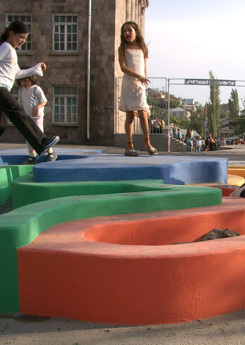
27 Non so(no) dove sono Spazi in-formazione e mappe performative Adriano Cancellieri Di quest onda che rifluisce dai ricordi la città s imbeve come una spugna e si dilata. Una descrizione di Zaira quale è oggi dovrebbe contenere tutto il passato di Zaira. Ma la città non dice il suo passato, lo contiene come le linee d una mano, scritto negli spigoli delle vie, nelle griglie delle finestre, negli scorrimano delle scale, nelle antenne dei parafulmini, nelle aste delle bandiere, ogni segmento rigato a sua volta di graffi, seghettature, intagli, svirgole. Le parole di Calvino (2002: 10), in uno dei suoi libri più ricchi e densi, Le città invisibili, rendono visibile la compenetrazione costitutiva tra noi e i nostri spazi quotidiani. Un intreccio banale, in quanto noi siamo sempre in qualche spazio, ma proprio per questo, un intreccio dato per scontato e, perciò, invisibile. Come ha sottolineato la fenomenologia e, in modo particolarmente efficace Merleau-Ponty, il mondo, gli spazi e i luoghi, sono incorporati dentro di noi e, allo stesso tempo, noi siamo interamente fuori da noi stessi, negli spazi e luoghi nei quali abitiamo. Ciò significa in primis che noi incessantemente costruiamo e addomestichiamo luoghi e che, tale connessione che creiamo con essi, è sempre un processo intriso di emozioni, di memorie, di desideri, di paure, come ci ricorda ancora Calvino (ibidem, 17-18) quando ci racconta un altra città invisibile, Despina: In due modi si raggiunge Despina: per nave o per cammello. La città si presenta differente a chi viene da terra e a chi dal mare. Il cammelliere che vede spuntare all orizzonte dell altipiano i pinnacoli dei grattacieli, le antenne radar, sbattere le maniche a vento bianche e rosse, buttare fumo i fumaioli, pensa a una nave, sa che è una città ma la pensa come un bastimento che lo porti via dal deserto, un veliero che stia per salpare, col vento che già gonfia le vele non ancora slegate, o un vapore con la caldaia che vibra nella carena di ferro, e pensa a tutti i porti, alle merci d oltremare che le gru scaricano sui moli, alle osterie dove equipaggi di diversa bandiera si rompono bottiglie sulla testa, alle finestre illuminate a pian terreno, ognuna con una donna che si pettina. Nella foschia della costa il marinaio distingue la forma d una gobba di cammello, d una sella ricamata di frange luccicanti tra due gobbe chiazzate che avanzano dondolando, sa che è una città ma la pensa come un cammello dal cui busto pendono otri e bisacce di frutta candita, vino di datteri, foglie di tabacco, e già si vede in testa a una lunga carovana che lo porta via dal deserto del mare, verso oasi d acqua dolce all ombra seghettata delle palme, verso palazzi dalle spesse mura di calce, dai cortili di piastrelle su cui ballano scalze le danzatrici, e muovono le braccia un po dal velo e un po fuori dal velo. Ogni città riceve la sua forma dal deserto a cui si oppone; e così il cammelliere e il marinaio vedono Despina, città di confine tra due deserti. Niente è, dunque, vissuto singolarmente, ma sempre in relazione alle sue adiacenze, alle Adriano Cancellieri svolge attività di ricerca come assegnista presso il Dipartimento di Sociologia dell Università di Padova. Ha scritto saggi e articoli sugli studi urbani ed etnografici, in particolare su come la costruzione e l uso dello spazio incidono su confini sociali e forme di appartenenza. adriano.cancellieri@unipd.it Random map-playgrounds (2003), ø500 cm, painted concrete 27
28 sequenze di eventi che portano ad esso, alla memoria delle precedenti esperienze (Lynch, 1960). In questo processo di quotidiana costruzione di spazi, un ruolo strutturante è giocato dalle pratiche discorsive, dalle parole, dalle narrazioni perché, come ha sottolineato de Certeau (1980), i racconti fanno da battistrada alle pratiche sociali per aprire loro un campo. A questo proposito suggestivo è il lavoro di Chatwin sulle Vie dei Canti (1987: 101), che racconta come, secondo i miti aborigeni, la creazione del mondo sarebbe avvenuta compiutamente solo nel momento in cui gli Antenati ne hanno risvegliato tutte le sue componenti, cantandole una ad una: In fondo alle loro buche (che ora si stavano riempiendo d acqua) gli Antenati distesero una gamba, poi l altra. Scrollarono le spalle e piegarono le braccia. Si alzarono facendo forza contro il fango. Le loro palpebre si aprirono di schianto: videro i figli che giocavano al sole. Il fango si staccò dalle loro cosce, come la placenta da un neonato. Poi, come fosse il primo vagito, ogni Antenato aprì la bocca e gridò: «lo sono!». «Sono il Serpente il Cacatua la Formica del Miele il Caprifoglio». E questo primo «lo sono!», questo primordiale «dare nome», fu considerato, da allora e per sempre, il distico più sacro e segreto del Canto dell Antenato. Ogni Uomo dei Tempo Antico (che ora si crogiolava al sole) mosse un passo col piede sinistro e gridò un secondo nome. Mosse un passo col piede destro e gridò un terzo nome. Diede nome al pozzo, ai canneti, agli eucalipti: si volse a destra e a sinistra, chiamò tutte le cose alla vita e coi loro nomi intessé dei versi. Gli Uomini del Tempo Antico percorsero tutto il mondo cantando; cantarono i fiumi e le catene di montagne, le saline e le dune di sabbia. Andarono a caccia, mangiarono, fecero l amore, danzarono, uccisero: in ogni punto delle loro piste lasciarono una scia di musica. Avvolsero il mondo intero in una rete di canto. La forza performativa dei racconti non vale certo solo per una popolazione così lontana come quella degli aborigeni australiani, perché anche per noi occidentali i racconti hanno un importanza costitutiva. Prova ne è, come ci ricorda ancora de Certeau (1980), che là dove i racconti scompaiono vi è perdita di spazio: privato di narrazioni il gruppo o l individuo regredisce verso l esperienza, inquietante, fatalista, di una totalità informe, indistinta, notturna. Ma questa costruzione quotidiana degli spazi intorno a noi non è un processo che avviene in una tabula rasa primordiale, perché lo spazio non è un vuoto che noi riempiamo con emozioni e discorsi a nostro piacimento, come a volte hanno lasciato intendere i geografi umanisti, che hanno pur avuto il grande merito di comprendere per primi l importanza della compenetrazione tra attori e spazi sociali (Relph, 1976). Infatti non siamo (sol)tanto noi che possediamo e costruiamo i luoghi ma anche i luoghi che posseggono pezzi di noi, che contribuiscono a costruire ciò che noi siamo. I luoghi sono, cioè, umanizzati ma anche umanizzanti, strutturati e strutturanti. è questa la cosiddetta dialettica socio-spaziale: noi diamo forma allo spazio e lo spazio ci in-forma incessantemente. Lo spazio è un testo che ci dice costantemente cosa e come guardare, cosa e come fare. Per comprendere tutto ciò, ancora una volta dobbiamo farci guidare da Calvino (2002: 13) che ci fa luce tra le sue città invisibili. Benvenuti a Tamara: Finalmente il viaggio conduce alla città di Tamara. Ci si addentra per vie fitte d insegne che sporgono dai muri. L occhio non vede cose ma figure di cose che significano altre cose: la tenaglia indica la casa del cavadenti, il boccale la taverna, le alabarde il corpo di guardia, la stadera l erbivendola altri segnali avvertono di ciò che in un luogo è proibito e di ciò che è lecito lo sguardo percorre le vie come pagine scritte: la città dice tutto quello che devi pensare, ti fa ripetere il suo discorso e mentre credi di visitare Tamara non fai che registrare i nomi con cui essa definisce se stessa e tutte le sue parti.
29 Il risultato di questa incessante costruzione degli spazi, e di questa continua in-formazione di questi sugli attori sociali, è che ogni attore e gruppo sociale dà forma a mappe di significato, disegnate nei minimi dettagli dagli occhi della mente, che si focalizzano su alcuni aspetti, lasciandone indistinti o oscuri altri. Mappe che rassicurano su ciò che è vicino o lontano, nostro o loro, sicuro o pericoloso, familiare o sconosciuto: mappe performative, e dunque fondamentali per costruire identità e confini sociali e, perciò, per supportare meccanismi di potere e di empowerment. Il cinema, forse il più grande produttore di paesaggi immaginari, per esempio, ci ha spesso mostrato come lo spazio sia usato per rendere più rigidi i Se è vero che siamo sempre immersi nello spazio, parafrasando confini sociali. Mi riferisco qui Eraclito potremmo dire che è impossibile immergersi due volte solo ad alcuni casi significativi nello stesso spazio come la nave del Titanic o la Metropolis di Fritz Lang; ma, a suo modo, anche alla reclusione forzata (sottoterra) del Nero in Underground di Kusturica. Il mondo è diviso in vari livelli e, sottoterra, o sottocoperta, ci sono le classi laboriose-pericolose o, comunque, gli esclusi. Ma tale contrapposizione così radicale, non è mai totalizzante e, soprattutto, non è mai statica: ci sono sempre contaminazioni e soprattutto possibilità di contaminazione; gli spazi di esclusione si rivelano, infatti, spazi sociali e di seduzione in Titanic, spazi di resistenza e ribellione in Metropolis e di edonismo esplosivo in Underground. Esplosioni di socialità illusorie, effimere, senza domani, magistralmente metaforizzate dall orchestra che continua a suonare anche quando il Titanic affonda o dal surreale matrimonio underground. Ciononostante esse sembrano esprimere la necessità e il bisogno di addomesticare lo spazio, di ri-significare gli spazi, di farsi spazio; bisogno che appare in tutta la sua forza proprio quando tale costruzione quotidiana è resa più difficile. E oggi sembra proprio che tale bisogno sia sempre più sacrificato a causa della crescente privatizzazione degli spazi pubblici (Sennett, 1977) e alla pervasività di un certo tipo, e soprattutto di un certo (ab)uso, di nuove tecnologie che rischia di far sì che le relazioni siano sempre più tra soggetti senza corpi e senza luoghi (Sennet, 1994). Questi processi, nel loro complesso, rischiano di intaccare profondamente il grado di insideness (Relph, 1976), di consapevolezza dell ambiente circostante, di connessione con e attraverso i luoghi. La possibilità, cioè, di costruire un senso del luogo. Il risultato è che tale necessità riemerge sotto altra forma e, in particolare, come ricerca di nuove piccole patrie, di spazi di rifugio, comunitari, autentici, fondati sulla paura dell eterogeneità, sul motto odiamo insieme. Per usare altre immagini cinematografiche, si cercano ossessivamente nuove Dogville in cui l abbraccio, apparentemente caldo, di un luogo, rischia solo di stringerti sempre di più sino a stritolarti, come è avvenuto a Grace, in modo crudele e spietato, nel capolavoro di Von Trier. Oppure si cercano nuovi Truman Show claustrofobici (se non nuove Matrix) dove tutto è pre-scritto e tutto dev essere esteticamente in ordine e dove, proprio per questo, è impossibile un rapporto estetico nel senso etimologico del termine, cioè sensuale ed emozionale, con i luoghi. Questa modalità di attaccamento al luogo e di bisogno di spazio è, infatti, troppo sterile e riduttiva, oltre che escludente e spesso violenta. Addomesticare quotidianamente gli spazi significa, infatti, molto di più. Perché il nostro bisogno di spazio è poliedrico e si esprime, da un lato, attraverso la ricerca di radicarsi, centrarsi e tirare il fiato, dall altro di spostarsi ed esplorare mondi sociali sconosciuti. 29
30 Occorre, perciò, mettere al centro l importanza costitutiva delle relazioni con lo spazio e attraverso lo spazio, ma occorre farlo accettando la natura plurale di tali relazioni e il fatto che si tratta di un processo instancabile, quotidiano e conflittuale perché se è vero che siamo sempre immersi nello spazio, parafrasando Eraclito, potremmo dire che è impossibile immergersi due volte nello stesso spazio. Tale processo assume, dunque, un ruolo fondamentale, perché gli spazi che formiamo, ci in-formano, dando forma a chi siamo noi e a chi sono gli altri. Riferimenti Calvino, Italo (2002) Le città invisibili. Milano: Mondadori. de Certeau, Michel (1980) L invention du quotidien 1. Arts de faire. Paris: Union générale d éditions; trad. it. (2001), L invenzione del quotidiano. Roma: Edizioni Lavoro. Chatwin, Bruce (1987) The Songlines. London: Picador; trad. it. (1988) Le vie dei canti. Milano: Adelphi. Lynch, Kevin (1960) The Image of the City. Cambridge: MIT Press; trad. it., (2008) L immagine della città. Venezia: Marsilio. Relph, Edward (1976) Place and placelessness. London: Pion. Sennett, Richard (1977) The Fall of Public Man. New York: Knopf, trad. it. (2006) Il declino dell uomo pubblico. Milano: Mondadori. Sennett, Richard (1994) Flesh and Stone: The Body And The City In Western Civilization. New York: Norton & Company.
31 Economia politica/ Geografie umane Intervista con Stefano Boccalini Adelina von Fürstenberg La tua mostra personale allo Studio Dabbeni di Lugano, che io ho curato, terminata alla fine di ottobre dello scorso anno [2008], si intitolava Economia politica/geografie umane. Guardando il lavoro esposto e pensando a questo titolo, mi viene in mente la dis-simmetria che oggi molto spesso esiste tra economia e politica, e la conseguente ricaduta sulla vita sociale. Nasce da qui il tuo lavoro? 1 In effetti, in questo progetto la dis-simmetria di cui tu parli diventa una modalità attraverso la quale metto in evidenza dei dati. Questi dati riguardano le guerre e la vendita delle armi, quindi dati politici, economici e, di conseguenza, sociali. In questo lavoro era per me importante visualizzare contemporaneamente due realtà che sono una la conseguenza dell altra ma che normalmente non vengono associate; quello che ho fatto è stato costruire una serie di mappe dove ho messo a confronto dei numeri che riguardano, da una parte, i morti delle guerre che alla fine del 2007 erano in atto nel mondo e, dall altra, i soldi che gli stati hanno guadagnato, sempre nel 2007, con la vendita delle armi. I dati che tu hai visualizzato attraverso queste mappe mi fanno pensare anche alle conseguenze della realtà che presenti: se ci sono in atto delle guerre, sicuramente si sono verificate delle migrazioni. È stata una scelta non spingerti oltre questi dati? Come ti dicevo in precedenza, questo lavoro nasce dalla volontà di mettere in relazione dei dati; è chiaro che da questi dati si può partire per studiare e presentare altre realtà che sono, come dici anche tu, una conseguenza, ma quello che mi interessava era far riflettere su come possa cambiare la percezione di un dato nel momento in cui viene messo in rapporto con questo o quel contesto: si tratta di una decisione che spinge chi guarda a considerare un aspetto della realtà che scegliamo di mettere in evidenza. Hai parlato di migrazioni e questa è un altra realtà che mi interessa studiare più a fondo, a cui forse in futuro dedicherò un lavoro specifico. Credo che le migrazioni, insieme all economia, o forse sarebbe meglio parlare di economia finanziaria, siano i temi da cui partire per ripensare un possibile modello di sviluppo che in qualche modo si allontani dai modelli attuali, anche perché credo che su queste due sfide si giochi la possibilità di guardare al futuro con serenità. Pensi a qualcosa di specifico quando parli di allontanarsi dai modelli attuali di sviluppo? Credo che se riuscissimo a modificare il nostro punto di vista sulla questione delle migrazioni, ripensandole come un opportunità e non come una minaccia per il nostro vivere e se potessi- 1 Questa intervista è apparsa inizialmente su Temporale n , pp Adelina von Fürstenberg ha fondato il Centre d Art Contemporain di Ginevra, diretto il Centre d Art Contemporain di Grenoble e fondato Art for The World, una NGO affiliata all ONU per la propomozione dei principi dell Dichiarazione universale dei Diritti Umani attraverso l arte. Ha organizzato eventi artistici in tutto il mondo e ha lavorato con numerosi artisti internazionali tra i quali Christian Boltanski, Daniel Buren, Francesco Clemente, Sol LeWitt, Andy Warhol, e Marina Abramovic, John Cage, Laurie Anderson, Philip Glass, Joan Jonas, Trisha Brown, Robert Wilson. 31
32 mo porre a servizio della società i profitti dell economia finanziaria, forse avremmo fatto un passo in avanti nel cammino che porta all annullamento dei conflitti. Questo tuo progetto oltre a presentare dei dati reali su questioni socialmente rilevanti ha un forte impatto visivo, direi che sono dei bei lavori anche dal punto di vista estetico. Questo elemento non rischia di far perdere forza al pensiero che sta dietro al tuo lavoro? Credo proprio di no, anzi penso che sia un punto di forza. Non ho mai ritenuto che per esprimere un pensiero attraverso il mio lavoro ci fosse bisogno di stupire lo spettatore. Preferisco La costruzione di una mappa mi dà la possibilità di rileggere un territorio attraverso delle modalità che io decido, quindi posso prendermi la libertà di associare una serie di elementi che mi permettono di presentare una realtà che altrimenti rimarrebbe nascosta la cultura contemporanea è largamente pervasa. farlo avvicinare all opera seducendolo per poi portarlo a riflettere su questioni che sono per me importanti: mi interessa di più un approccio riflessivo al lavoro, rispetto alla spettacolarizzazione di cui In effetti, in questo tuo lavoro trovo che ci sia un equilibrio perfetto tra contenuto ed estetica: sei riuscito a restituire il senso del tuo pensiero in modo molto efficace, hai trasformato dei dati scientifici in un opera d arte, dando una visione inaspettata della geografia del mondo. Un altra cosa che mi interessa capire è il tuo rapporto con la cartografia, vorrei che tu mi spiegassi cosa significa per te lavorare su un supporto che di per sé è già politico, come la mappa del mondo. Per me questo costituisce la possibilità di mettere in risalto delle realtà sociali che mi interessa evidenziare: la costruzione di una mappa mi dà la possibilità di rileggere un territorio attraverso delle modalità che io decido, quindi posso prendermi la libertà di associare una serie di elementi che mi permettono di presentare una realtà che altrimenti rimarrebbe nascosta. L utilizzo delle mappe non è una novità nel tuo lavoro, penso ad esempio a Stone Island, il lavoro che hai dedicato alle persone anziane del quartiere Isola di Milano, dove la mappa del quartiere viene invasa dai loro ritratti come una sorta di riappropriazione da parte loro dello spazio pubblico, ma penso anche alla serie di lavori che hai intitolato Random Map, dove l elemento geografico perde la sua riconoscibilità per andare a comporre degli spazi che possono ospitare delle funzioni, e rispetto a questo penso al parco giochi che hai costruito per Art For The World a Yerevan in Armenia, ma anche ai tappeti che ricostruiscono l Europa attraverso le sagome dei paesi d origine delle comunità migranti. Qual è il legame tra questi lavori? Tutti questi lavori nascono dalla mia esigenza di guardare alla realtà che mi circonda come ad un possibile campo di azione. A volte questo campo si restringe a livello locale, come ad esempio nel caso del quartiere Isola, il luogo di Milano dove ho abitato per molti anni e dove ho attivato una serie di progetti per contrastare un modello di sviluppo della città che non mi appartiene; altre volte il campo di azione diventa globale e le realtà di cui mi occupo sono realtà che assumono questa dilatazione ma le cui conseguenze sono da noi vissute su scala locale: Economia Politica/Geografie Umane ne è proprio un esempio. Economia politica/geografie umane (2008), 21x29.7 cm, mixed technique
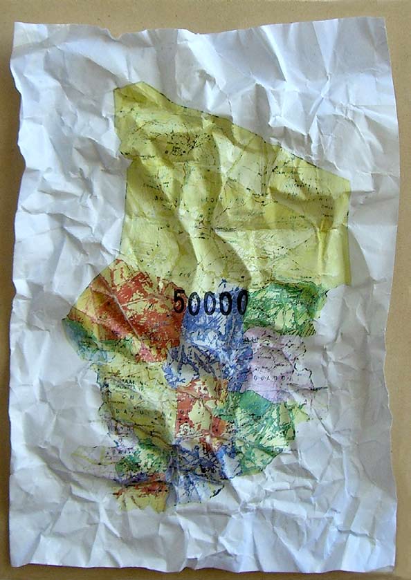
33 33
, 105x170 cm, mixed technique")
34 Economia politica/ geografie umane (2008), 105x170 cm, mixed technique (detail)

35 Stefano Boccalini è docente di Arte Pubblica alla NABA di Milano, consulente dell Archivio Gianni Colombo, ed è tra i fondatori di Isola Art Center. Partecipa a mostre, progetti e interventi nello spazio pubblico dove attiva nel territorio e con le comunità processi di conoscenza e di scambio che sono la base della progettazione partecipata dalla quale prende corpo il suo lavoro. Attualmente sta lavorando al progetto per la sua prossima mostra che aprirà a giugno all Hangar Bicocca di Milano, a cura di Chiara Bertola. 35

36
37 Re-weaving fragmented space-time. Notes from a mapping project in Palestine Nasser Abhourame Laura Ribeiro Defeat. Failure. Loss. Archives of rage. The sedimentation of deferred dreams. Each new juncture in (post)colonial temporality, every potential opening (even those that formally end in victory) seems to bring with it each time with seemingly equal totality these relational figures. And yet somehow the wheel keeps turning. Each repetition feels somewhat different from the last. But, what happens when official historical discourse falls jarringly out of synch with society s lived and inherited memory? Or when territorial delineations of political membership elide people s affective attachments to place? What happens when semiotic registers cannot engender productive modes of intersubjectivity and mutuality? When representation and signification are no longer commensurate with experience? When the symbolic order so critical in nation-building and subjectification is exposed as hollow and begins to crumble? And what can intellectual-cultural and representational practice like mapping say and do in such a context? The moment, wrote Iritt Rogoff, in which loss is clearly marked and articulated is also the moment in which something else, as yet unnamed, has come into being (2000: 195). But, this beggars the question, what about the interstices, the lapses or the lacunae between the new coming in and the old fading out? There is a penumbral space here of sharp dissonance and flux as non-commensurate temporalities, desires, schemes, machinations all vie and clash with each other. These questions posit themselves in between the emergence of a new political order and the dissolution of past configurations. They often, as in the case of Palestine today, produce an acute temporal and spatial disjuncture in societies still disoriented by the trauma and violence of the colonial. The defeat of the latest Palestinian uprising (the Intifada) has laid the groundwork for a multi-faceted re-patterning of fractured subjects through the intertwined modalities of statecraft-govermentality and the new possibilities of consumption-lifestyle choice the hard and soft anesthetization of trauma. Atop broken hopes, the very essence of Palestinian subjecthood is being redefined through a statist project inexorably embedded within the mechanics of colonial machinery; through a nascent political regime that is not only coproducing existent colonial structures and categorizations but also the latter s concomitant fragmentation of the indigenous body politic. What has emerged is something we have else- Nasser Abourahme is a researcher and writer currently working on a community-based urban planning project in two West Bank refugee camps. His research interests broadly coalesce around the intersections of coloniality, space and subjectivity. Laura Ribeiro is a legal researcher with interests in the issues of colonial jurisprudence, legal geographies and the genealogy of sovereignty. She currently lives and works in the West Bank. nasser.ab@gmail.com l.ribeiro10@gmail.com Economia politica/ geografie umane (2008), 21x29.7 cm, mixed technique 37
38 where dubbed post-colonial colonialism (Abourahme 2009): the conjugation of colonialism and its post, the collapsing of seemingly sequential, diachronic stages into a synchronic but incoherent whole. The coexistence of indigenous but contingent micro-freedoms with total colonial sovereignty. Bantustan-plus. Enthralled by the will to power, by the statist fantasy, political elites convinced of their own arrival are breaking-away. In a society that used to largely shun ostentatious displays of wealth new inequalities are materializing in part the result of the grafting of the most abrupt of neoliberal relations onto social structures still reeling from colonial encampment and besiegement. Internal securitization and coercion by what to many appears as a proxy colonial police force are finishing off what was left of polyphonic political community. Reinforced by a fetishism of law and order, jurisdictional categorizations largely inherited from and overlapping with colonial practices are hardening and in the process, Palestinian mutual estrangement has never been more pronounced. Today, a bewildering range of classifications modulates mobility and entitlement across two formally distinct but in practice singular jurisdictional space(s). Perhaps one of the most significant corollaries of all this has been the emergence of a crisis in geographical and temporal imaginaries. With anxious authority the statist project has in part through maps redrawn the geo-historical boundaries or outer limits of Palestine, homeland, justice. The politics and geography of liberation, previously premised on an expansive and utopic restitution of historic, pre-nakba Palestine give way to the narrow, territorial projections of the reifications of state; i.e. the colonially delineated and cantonized contemporary West Bank. The remembered, the desired, the longed for and their geographies are overwritten by the imperatives of compromise, security, state. Political horizon narrows. Shared geographical imaginaries shrink. Common narratives are lost and the claims of memory grow dim. This involves at heart a severing with the past and its signposts that were so critical in pointing the way forward. The unspoken, the assumed, what Michael Taussig calls, the mythic naturalisms of the political unconscious of an epoch (1987: 8) are no longer in play. This has pushed a defeated society into a deep and fractured stasis. A contrived normality and with it a kind of stillness and transience reigns ironically among the most frenzied urban and institutional expansion society has ever seen. Without shared navigational principles people are unmoored; unable to decipher or read the current landscape; to make sense of their trauma, or even locate its source. What can representational practice make of all this? In light of the dissonance between most representation and people s lived, corporal experience how can mapping (of all the discredited practices of signification) capture an essence of actuality? Can the kind of abstraction inherent in mapping help make sense of trauma? Can it, at least, visibly re-render that which has been repressed and pushed outside refugees, resistances, disaffection, Jerusalem? If at its most abstract mapping (as distinct from cartography) is about the visual articulation of the relationality between subjects and objects along (as opposed to just across) space and time (Ingold 2006), can it re-weave fragmented spatio-temporalities? Can it show the continuities of historical processes, the interwoveness of temporal periods? Or, in other words that the past in the most material terms continues to co-produce the present, that history remains the unfolding of colonial dispossession and erasure under various guises.
39 If mapping can make the denial of connections absurd (Paglen 2008: 41) can it de-reify political structure? Can it expose the hidden arrangements, contingencies and illusions at the heart of the simulacrum that is Palestine s state-building? At one level mapping can sketch, trace, reorder and reprocess movement, subjects, space, time, place in ways that challenge existing symbolic hierarchies. It can come to re-present or re-situate a more dynamic articulation of the colonial present, supporting a questioning, a repositioning, a speculative realignment. Maybe even a different archive. Certainly, as a scheme of visibility, mapping can, to paraphrase Frederic Jameson, pose questions about a strategy for delegitimizing existing discourse at a particular historical juncture (1990: 354). For a mapping exercise to not only circumvent these modalities but also transgress them, would require a different conceptual working vision, one that projects uncertainties as well as potentialities, tensions as well as imaginaries But at the same time mapping is an acutely problematic practice and technology. It comes loaded with ideological and historical baggage as the epistemic structure par excellence in the signifying practices that naturalized and reproduced colonial geography and power. Israeli cartography has always been at the forefront of a colonial order constantly re-territorialized through maps, architecture and urban planning. That maps lend themselves to power is clear. The very rendering process needed to generate such form is a process laced with interest involving the definition and selection of points and nodes (as well as the trails between them), signifiers and relationalities; a setting up of points of entry and exit; an organization of a field of vision. Subjective processes in essence, readily instrumentalized. Moreover, there is an aporia here that goes beyond the problematic of objectivity. By appropriating mapping as a form, is there not the risk of reproducing the very reifications such an exercise would seek to deconstruct? Would it not always imply a symbolic ordering, new illusions of wholeness and epistemological certainty? For a mapping exercise to not only circumvent these modalities but also transgress them, would require a different conceptual working vision, one that projects uncertainties as well as potentialities, tensions as well as imaginaries. Mapping as a cultural form that is not totalizing, does not propose full knowledge; but rather embraces its own partiality and incompleteness, reveals itself as a construction, recognizes the unmappable and is avowedly situated and positioned (Hunt 2007). It is under these navigational principles that we experiment with mapping broadly conceived as a way of seeing. In contemporary Palestine, such a project can take multiple directions: mapping the overlapping apparatuses of subjectification classification of subjects, securitization, law and order, institutional reforms, urban planning, pedagogical institutions etc. Mapping subjective practices that transgress categorizations and boundaries returns to vanquished villages, expansions of refugees beyond camp borders, the evasions and movements of loitering and hawking youth etc. Mapping the imbrications of power and effect, the crossovers between centers of influence and transformation. Mapping the production of contemporary discourse and the staging of event and spectacle. Mapping the relationality of the constitutive components territorial and otherwise that interact to produce space in contemporary Palestinian cities the camp, the village, the colony, the prison, the checkpoint. It is an exercise that seeks to gather, re-read, re-interpret and re-present, not through homo- 39
40 logical collapsing but nonetheless by bringing together the fragments of a temporal dialectic into a perceptible present. A new image of actuality. In this project we invite the wayfarer to co-produce the journey, to arrive or get lost in a fragmented Palestine. It is an open-ended discussion, an interactional aesthetic. A mapping of a problematization as well as a problematization of mapping. And in the end maybe just an ambling through possibilities. Ritessere uno spaziotempo frammentato. Note da un progetto di mappatura in Palestina Sconfitta. Fallimento. Perdita. Archivi di rabbia. Sedimentazione dei sogni differiti. Ogni nuovo snodo nella temporalità (post-)coloniale, ogni potenziale apertura (persino quelle che formalmente vengono sancite come vittorie) sembra portare con sé ogni volta apparentemente accumulando il medesimo totale queste figure di relazione. Eppure in qualche modo la ruota continua a girare, ogni ripetizione pare in qualche modo diversa dalla precedente. Ma cosa accade quando il discorso storico ufficiale finisce fastidiosamente fuori sincrono rispetto alla memoria vissuta ed ereditaria della società? O quando il modo in cui si configura l appartenenza politica contraddice l attaccamento affettivo delle persone ai luoghi? E ancora, che accade quando i registri semiotici non riescono a generare delle modalità produttive di intersoggettività e mutualità? Quando cioè la rappresentazione e la significazione non sono più commisurate all esperienza? Quando l ordine simbolico tanto cruciale sia nella costruzione nazionale che nella soggettivazione personale si rivela essere vuoto e comincia a tremare? E cosa può dire e fare in tale contesto una pratica intellettual-culturale e rappresentativa come il mappare? Il momento in cui la perdita è chiaramente segnata e articolata ha scritto Iritt Rogoff è anche il momento in cui qualcos altro, ancora senza nome, comincia ad esistere (2000: 195). Un osservazione del genere però suscita un ulteriore domanda: che accade negli interstizi, nei lassi che intercorrono e nelle lacune tra il nuovo che arriva e il vecchio che scompare? C è uno spazio in penombra, di acuta dissonanza e di flusso, in cui temporalità, desideri, schemi e macchinazioni non commensurabili tra loro competono e si scontrano. Tali le questioni che si pongono nell intervallo tra l emergere di un nuovo ordine politico e la dissoluzione delle configurazioni passate. Spesso, come nel caso della Palestina oggi, si produce un acuta disgiunzione temporale e spaziale in una società ancora disorientata dal trauma e dalla violenza coloniale. La sconfitta dell ultima insurrezione palestinese (l Intifada) ha aperto il campo a una sfaccettata riconfigurazione di soggetti sociali frammentati nella duplice modalità intrecciata della governamentalità di stato e delle nuove possibilità di stili di vita improntati al consumo (l anestetizzazione dura e quella morbida del trauma). In cima a queste speranze spezzate, l essenza stessa della soggettività palestinese sta venendo oggi ridefinita attraverso un progetto statuale inesorabilmente inserito nel meccanismo della macchina coloniale, il tutto attraverso un nascente regime politico che sta riproducendo non solo le strutture e le categorizzazioni coloniali esistenti ma anche la concomitante frammentazione del corpo politico indigeno, operata da quelle stesse. Quel che ne è emerso è qualcosa che altrove ho chiamato colonialismo postcoloniale (Abourahme 2009): l unione
41 del colonialismo e del suo post, il venir meno di fasi apparentemente diacroniche e sequenziali in un tutto sincronico e incorerente. La coesistenza di micro-libertà indigene contingenti e di una sovranità coloniale totale: Bantustan-plus. Elettrizzate dal sogno statale dell esercizio del potere, le élite politiche convinte della propria riuscita non vengono controllate. In una società che in larga misura rifiutava ogni tipo di ostentazione della ricchezza si vanno ora materializzando nuove disuguaglianze in parte risultato del trapianto del neoliberalismo più brutale in strutture sociali ancora sconvolte dall esperienza dei campi profughi e dall assedio coloniale. La securitizzazione interna e la coercizione da parte di quella che a molti appare come un prolungamento della polizia coloniale stanno facendo piazza pulita di quel che era rimasto di una comunità politica polifonica. Facilitate da un feticismo del law and order, le categorizzazioni giurisdizionali ampiamente ereditate da e sovrapposte alle pratiche coloniali si stanno consolidando nel momento in cui l estraniamento reciproco tra i palestinesi non è mai stato tanto pronunciato: oggi come oggi un incredibile gamma di classificazioni modula il diritto alla mobilità attraverso i due spazi giurisdizionali, formalmente distinti ma in pratica uniti. Il corollario forse più significativo di questa situazione è la crisi degli immaginari geografici e temporali. Ansioso di esercitare la propria autorità, il progetto statale ha in parte attraverso le mappe ridisegnato i confini geo-storici e i limiti esterni della Palestina, della terra natale e della giustizia. La politica e la geografia della liberazione, prima basate sull idea di una restituzione ampliata e utopica di una Palestina pre-nakba, lasciano ora spazio alle proiezioni strettamente territoriali delle reificazioni di stato, come ad esempio la West Bank, delineate e compartimentate secondo l influenza coloniale. Il ricordo, il desiderio, il sogno e le loro geografie vengono sovrascritte dagli imperativi del compromesso, della sicurezza, dello stato. L orizzonte politico si restringe. Gli immaginari geografici condivisi si riducono. Le narrazioni comuni vanno perdute e le esigenze della memoria vengono adattate. Si rompe con il passato e con i paletti che allora si erano posti per andare avanti. Il non-detto, il presupposto, quelli che Michael Taussig chiama i naturalismi mitici dell inconscio politico di un epoca (1987: 8), non si applicano più. Ciò ha spinto una società sconfitta in una stasi profonda e internamente divisa. Una normalità imposta e con essa un immobilità e un efemeralità regnano ironicamente proprio nel momento di un espansione urbana e istituzionale mai vista prima. Senza principi condivisi la gente si ritrova disancorata, incapace di decifrare o leggere il paesaggio attuale per dare senso al proprio trauma, o anche solo per identificarne l origine. Cosa può fare la pratica rappresentativa in questo contesto? Alla luce della dissonanza tra la rappresentazione e l esperienza vissuta e corporea delle persone come può il mappare (tra tutte le pratiche discreditate di significazione) catturare un essenza dell attualità? Il tipo di astrazione inerente al processo di mappatura può aiutare a comprendere il trauma? Può, quantomeno, restituire visibilmente tutto ciò che è stato represso e spinto fuori rifugiati, resistenze, disaffezione, Gerusalemme? Se su un piano più astratto il mappare (in quanto distinto dalla cartografia) riguarda l articolazione visuale della relazionalità tra soggetti lungo (e non solo attraverso) lo spazio e il tempo (Ingold 2006), può esso servire a ritessere queste spazio-temporalità frammentate? Può servire a mostrare le continuità dei processi storici, l interconnessione dei periodi temporali? A mostrare, in altre parole, come il passato continui nei termini più materiali a co-produrre il presente, come la storia rimanga una storia di usurpazione coloniale e di cancellazioni di vario tipo? Se il mappare è in grado di rendere la negazione delle connessioni assurda (Paglen 2008: 41), può anche servire a de-reificare la struttura politica? A rivelare i patti nascosti, le contingenze e le illusioni al cuore di quel simulacro che è lo state-building palestinese? Ad un certo livello, mappare può abbozzare, tracciare, riordinare e riprocessare il movimento, i soggetti, lo spazio, il tempo e il luogo, in modalità che sfidino le gerarchie simboliche esistenti; può ri-presentare o ri-situare dinamicamente l articolazione del presente coloniale, favorendo un interrogazione, un riposizionamento, un riallineamento speculativo forse persino un diverso archivio. Certo, in quanto schema di visibilità, il mappare può, per parafrasare Frederic Jameson, sollevare la questione della strategia per delegittimizzare il discorso esistente in una particolare congiuntura storica (1990: 354). Ma al tempo stesso mappare è una pratica e una tecnologia estremamente problematica, che si dà carica di un bagaglio ideologico e storico: struttura epistemica per eccellenza di quelle pratiche di 41
42 significazione che hanno naturalizzato e riprodotto la geografia e il potere coloniale. La cartografia israeliana è sempre stata in prima linea nel potere coloniale, costantemente ri-territorializzato attraverso mappe, architettura e pianificazione urbanistica. Che le mappe si prestino al potere è chiaro. Lo stesso processo che serve a generare la loro forma è un processo intrecciato a un interesse che riguarda la definizione e la selezione di punti e nodi significanti (oltre che dei percorsi tra essi) e delle loro relazioni: una predisposizione di punti di entrata ed uscita, l organizzazione di un campo di visione. Sostanzialmente, processi soggettivi prontamente strumentalizzati. Per di più, c è un aporia che va ben oltre la problematica dell oggettività. Appropriandosi del mappare come forma, non c è forse il rischio di riprodurre le stesse reificazioni che questo esercizio ambirebbe a decostruire? Non implicherebbe sempre un ordine simbolico, nuove illusioni di interezza e di certezza epistemologica? Affinché un esercizio di mappatura non solo aggiri queste modalità ma anche le trasgredisca, ci vorrebbe una diversa visione concettuale di lavoro, che sia capace di proiettare anche le incertezze e le potenzialità, le tensioni e gli immaginari. Intendere il mappare come una forma culturale non totalizzante che non propone una conoscenza completa, al contrario, che abbraccia la propria parzialità e incompletezza, rivela se stesso come una costruzione, riconosce il non mappabile, e resta pratica apertamente situata e posizionata (Hunt 2007). Con questi principi di navigazione stiamo sperimentando con il mappare, ampiamente inteso come modo di vedere. Nella Palestina di oggi, un progetto di questo tipo può prendere molteplici direzioni: mappare gli apparati sovrapposti di soggettivazione classificazione dei soggetti, securitarismo, law and order, riforme istituzionali, pianificazione urbanistica, istituzioni pedagogiche e così via. Mappare le pratiche soggettive che trasgrediscono le categorizzazioni e i confini i ritorni a villaggi rasi al suolo, l espansione dei rifugiati oltre i confini dei campi, le evasioni e i movimenti di una gioventù disoccupata ed estremista, e così via. Mappare gli intricamenti del potere e dei suoi effetti, gli sconfinamenti tra centri di influenza e di trasformazione. Mappare la produzione del discorso contemporaneo e la messa in scena dell evento e dello spettacolo. Mappare la relazione delle componenti costitutive territoriali e altro che interagiscono per produrre lo spazio nelle città palestinesi contemporanee il campo, il villaggio, la colonia, la prigione, il checkpoint. è un esercizio che cerca di ri-radunare, ri-leggere, re-interpretare e ri-presentare, non attraverso un collassamento omologico ma nondimeno radunando i frammenti di una dialettica temporale in un presente percepibile: una nuova immagine dell attualità. In questo progetto invitiamo il viandante a co-produrre il viaggio, ad arrivare o perdersi in una Palestina frammentata. Si tratta di una discussione aperta, di un estetica interattiva, che è insieme il mappare una problematizzazione e la problematizzazione di questo mappare. E alla fin fine forse solo un vagabondare tra possibilità.
 Representations of the Erased. Interview with Natascha Sadr Haghighian March 2007. http:// www.16beavergroup.org/ashley/ahunt_3.pdf Ingold, T. (2006) Up, Across and Along.")
43 Economia politica/ geografie umane (2008), 21x29.7 cm, mixed technique References Abourahme, N. (2009) The Bantustan Sublime. City Vol 13 Issue 4 Dec 2009 pp Hunt, A. (2007) Representations of the Erased. Interview with Natascha Sadr Haghighian March Ingold, T. (2006) Up, Across and Along. Place and Location: Studies in Environmental Aesthetics and Semiotics No. 5 pp Jameson, F. (1990) Cognitive Mapping. In Nelson, C. and Grossbes, L. (eds.) Marxism and the Interpretation of Culture. Urbana: University of Illinois Press. Paglen, T. (2008) Mapping Ghosts. In Mogel, L. and Bhagat, A. (eds.) An Atlas of Radical Cartography. Los Angeles: Journal of Aesthetics & Protest Press. Rogoff, I. (2000) Terra Infirma. London; New York: Routledge. Taussig, M. (1987) Shamanism, Colonialism and the Wild Man. Chicago: University of Chicago Press. 43

44
45 Mapping Informality Ed Wall Informality is a social construction. (Laguerre 1994: 6) Far from holding up a simple mirror of nature that is true or false, maps redescribe the world like any other document in terms of relations of power and of cultural practices, preferences, and priorities. (Harley 2001: 35) While often understood as objective processes both mapping and informality are social constructs defined through a lens of subjectivity. This highlights the problematic nature of mapping the informal a process loaded with complexity and contradiction. This essay explores Michel S. Laguerre s book Informal City and a project by Ed Wall and Sam Johnston called Informal Public (completed in 2008 for the London Festival of Architecture) in order to understand the informal and the potential that this has for the contemporary city. The aim of the Informal Public project was to explore the processes of change that public space undergoes during redevelopment. The project began by recording the public space activities that occurred in Elephant and Castle in South London. This involved mapping the locations of the public space activities and then marking these specific public spaces; the markings became part of the public space being recorded. The project identified many public space activities that opposed the formal structures of the space structures defined through planning, ownership and management of the space. Observing, recording and mapping these activities, within the context of future redevelopment and wider research into informality and the city, provided a means for understanding the ongoing processes of informality in Elephant and Castle. The mapping and marking in the Informal Public project became a means for exploring the definition of informality. It appeared that the existing activities resisted the formal systems, structures and intentions of the space. Laguerre recognizes this resistance of the informal but states that the informal emerges in two directions, either through the intentionality of the actor, or through the external construction of informality by the audience (Laguerre 1994: 7). This provided two perspectives from which to view the Informal Public project; the first demonstrating the consciousness of the informal actor in resisting the formal system such as pan-handling, vending and leafleting while the latter is seen in the conscious decisions of the formal owners, managers and legislators to define the rules and limits of the space. The informal is always defined by its relationship to the formal. Laguerre states that while the informal system may seem to produce its own definition of itself it either accepts or resists the rules of the formal system (Laguerre 1994: 11). Mapping the informal in Elephant Ed Wall is a landscape architect and urban designer based in London. He is acting course director for the BA(Hons) Landscape programme at Kingston University and a visiting professor at Politecnico di Milano (DIAP). He has also been a visiting critic at the Bartlett (UCL), Columbia University (GSAPP) and City College New York (CUNY). His design work has been exhibited at the Van Alen Institute, XV Quito Pan-American Architecture Biennale, the London Architecture Festival and at the Building Centre in London. Ed co-authored Basics Landscape Architecture: Urban Design which was published by AVA Publishing in ed@onehundredprojects.com Economia politica/ geografie umane (2008), 105x170 cm, mixed technique (detail) 45
46 and Castle was not possible without understanding the formal systems of the space; land ownership, management, maintenance and regulation became a framework against which to view the informal. Through mapping the formal space, as a structure from which to understand the informal, the multiple overlapping authorities appeared increasingly complicated. These formal structures are defined by social as well as legal norms creating a gradient of informality from that of non-compliance to the illegal. There are social practices that are informal because they resist social norms, rather than legal ones, and even some activities that are informal because there are no rules that would include them as formal. These degrees of difference make the Mapping the flux between the formal and the informal requires mapping processes of time and change Economia politica/ geografie umane (2008), 105x170 cm, mixed technique (detail) to create ambiguous dynamics across public space. process of mapping informality problematic. Both the actions of informality and the formal systems that define them multiply This relationship between the formal and the informal is understood from many perspectives. Laguerre provides several definitions of the informal. These include: the informal as an alternative system; the formal and the informal as opposite poles of the same system; the informal as an enclave within the formal; the informal as a marginal system; and the informal as a parasitic system. Most of these definitions can be identified in the public space activities recorded in the Informal Public project. However, the informal as a pre-formal system involves processes of time and therefore becomes significant when considering the redevelopment of the space. Will these public space activities be accommodated in new plans for the city? Will they be relocated to less prominent locations? Will they inspire new urban processes? Or will they be designed out of the city so that more formally accepted uses can take their place? The relationship between the formal and the informal is also constantly changing. As social attitudes change the boundaries between the two fluctuate; what once may be deemed to be informal can soon become accepted into the formal structures of the city, and vice versa. Laguerre describes several structural origins of the informal, which include: informality preceding the formal system; informality emerging from a superimposed formal system; informality adapting to a superimposed formal system; informality emerging through an act of aggression; informality as defined by law; informality as an outgrowth of the formal; informality coming from the inflexibility of the formal; and finally, informality emerging from a failure in formal systems. This allows us to see a changing of conditions, when applied to the city, from the formal to the informal and back again. The informal as a pre-formal condition demonstrates the potential for existing urban form and activities becoming formalised into the structures of the city. Mapping the flux between the formal and the informal requires mapping processes of time and change. The Informal Public project mapped the change in spatial form over several decades; however there were limitations in mapping the social activities over the same period of time. Although this was not the primary aim of the Informal Public project the ability to monitor, record and map the data would be important for any attempt to map the flux between the formal and the informal. How can you map complex situations that are constantly changing over time? Two contrasting approaches suggest potential solutions. Firstly, Robert E. Horn s mess maps that are an attempt to make communication easier, quicker and
![more accurate in the face of [the] immense complexity and information overload challenge the process of making and communicating complex social situations (Abrams & Hall 2006).](/docs-images/17/97713/images/47-0.jpg "The other potential is in recent software that has facilitated projects, such as Manhattan Timeformations by Brian McGrath (http://www.skyscraper.org/timeformations/intro.")
47 more accurate in the face of [the] immense complexity and information overload challenge the process of making and communicating complex social situations (Abrams & Hall 2006). The other potential is in recent software that has facilitated projects, such as Manhattan Timeformations by Brian McGrath ( interactive dynamic maps that allow the processes of time to be revealed with an elegance and fluency. The Informal Public project did not aim to map the flux between the informal and the formal: it aimed to explore the processes of social and spatial change in public space. However, during the project different mapping exercises allowed these processes, and in particular the definitions and processes of informality, to be explored. Rather than creating definite spatial representations of social activities in public space the process of mapping provided a tool to make sense of the relationships between the informal and the formal within urban public space. References Abrams, J. & Hall, P. (eds)(2006) Else/Where Mapping: New Cartographies of Networks and Territories. Ann Arbor: University of Minnesota Press. Harley, John Brian (2001) The new nature of maps: essays in the history of cartography. Baltimore: Johns Hopkins University Press. Laguerre, M. (1994) The Informal City. St. Martin s Press: London. 47
, 105x170 cm, mixed technique")
48 Economia politica/ geografie umane (2008), 105x170 cm, mixed technique (detail)
49 Mapping as dreaming Andrea Mubi Brighenti In a fascinating ethnography conducted in the 1970s among the Beaver Indians, a hunting tribe of the Northwestern territories and British Columbia, Canada who hunt and fish animals such as the moose, the caribou and the rainbow trout the anthropologist Hughes Brody (1998[1981]) describes a remarkable hunting practice 1. Brody warns us as presumably he himself has been warned by the Indians that it is particularly difficult for outsiders, and for Western people in general, to understand such a practice. It is called dream-hunting, and works as follows: Some old-timers, men who became famous for their powers and skills, had been great dreamers. Hunters and dreamers. They did not hunt as most people do now. They did not seek uncertainly for the trails of animals whose movements we can only guess at. No, they located their prey in dreams, found their trails, and made dream-kills. Then, the next day, or a few days later, whenever it seemed auspicious to do so, they could go out, find the trail, re-encounter the animal, and collect the kill. (ibid., 44) Andrea Mubi Brighenti researches into space, society and power, with a focus on urban environments. He has recently published Migrant Territories. Space and Control of Global Mobility (ombre corte, 2009) and edited The Wall and the City (professionaldreamers, 2009). Forthcoming: Visibility in Social Theory and Social Research (Palgrave Macmillan, 2010). andrea.mubi@gmail.com In a sense, we can say that during dream-hunting the right trails are recorded by the dreamer in a map that subsequently guides the fully awake hunter towards his prey. To my mind, this practice of dream-hunting illuminates an important character of mapping at large, and how we could conceptualise it today. Very summarily, and a bit roughly, two major waves of epistemological reflection on cartography have unfolded in the last thirty years or so. Both brought crucial insights, consequently they should not be represented in merely evolutionary terms. The first wave is critical cartography, in which sociological notions from the Frankfurt School (Adorno and Horhkeimer 1947), social constructionism (Berger and Luckmann 1966), epistemological genealogy (Foucault 1966) and domination theory (Bourdieu 1994) were more or less directly and more or less consciously applied to cartography. At the core of this movement is the idea that maps exercise a form of power: maps are not neutral but serve interests (Wood 1992); consequently, they are always used and above all misused (Monmonier 1996). The second wave is postrepresentational cartography (Thrift 2008; Dodge, Kitchin and Perkins eds. 2009; Kitchin, this issue; Crampton, this issue). The central 1 I wish to thank Ken Caine for making me discover Hughes Brody s work and other researches on Canadian First Nations hunters. 49
50 insight in this new cartographic conception is that maps are in fact mappings. There is a shift here from the object to the process and the act. This theoretical shift may in part be due to the fact that software has visibly changed the way of making, updating, transforming and using maps: not only do we have self organising maps and multi-user mapping platforms, but mapping systems are embedded in all sorts of everyday objects they are so to speak territorially decanted. Most important, however, is the idea that maps are similar to acts, interactions and situations. In my view, this processual turn in cartographic thinking is especially promising if we couple this insight with the recognition of the plurality of dimensions of socio-material action. Regarding maps as mappings questions not simply their epistemological dimension (what kind of knowledge do they produce), for once we accept that maps are acts, the vast array of social dimensions of action comes into play. Action can no longer be reduced by sociologists to the classic quadripartite Weberian scheme (purpose-rational, value-rational, traditional, emotional most notably, Weber himself did not regard this list as close or even complete!). On the contrary, it must be enriched with a multiplicity of further dimensions: the experiential, the creative, the tacit, the aesthetic, the sensorial, the resistant, the corporeal, the transformative, the affective... Understood as acts, mappings include the whole extent of such a plurality and, from this point of view, dream-hunting provides a most vivid illustration of the importance of the affective dimension of maps. That the map is an affect is best revealed by the exclamation of one of Brody s hunters: How can anyone who has not dreamed the whole route begin to locate himself on such a map? (Brody 1998[1981]: 47). This is a type of immanent mapping which Tim Ingold (2007) has recently called mapping along, as opposed to mapping across : on the one hand, mapping while following a path (along), on the other mapping by establishing distances and relations between points (across). The latter corresponds to the traditional conception of the map as a detached, synoptic view from a position of surplomb; the former corresponds to mapping as wayfaring, for instance dream-hunting among Beaver Indians. Some old-timers, men who became famous for their powers and skills, had been great dreamers. Hunters and dreamers It is beyond my capacities to investigate dreaming, but I would simply like to remind that, far from considering it as a private, individual psychological state, we should place dream in the context of social, collective and even universal myths and narratives. Both myths and dreams are about the deep involvement of the human being and his/her body in the world, the deep, intimate continuity of location, emplacement and inhabiting an embeddedness which breeds experience and/as imagination: a perceptually haptic vision, an immanent mapping along. As Elias Canetti once reflected: Tribes, sometimes consisting of just a few hundred people, have left us a wealth that we certainly do not merit, for it is our fault that they have died out... They have preserved their mythical experience until the very end, and the strange thing is that there is hardly anything that benefits us more, hardly anything that fills us with as much hope as these early incomparable creations by people who, hunted, cheated, and robbed by us, have perished in misery and bitterness. Scorned by us for their modest material culture, blindly and ruthlessly exterminated, they have left us an inexhaustible spiritual legacy. (Canetti 1979: 241)
51 This passage is not only about the moral and political crimes of colonialism, but also about the threatened human capacity to inhabit the world in a non-destructive way. Dream-hunting points to a zone of indistinction where it is not only possible to say that dreams are maps, but where we can venture to observe that maps are dreams. Thus, at the core of one of the weapons of choice of political, cultural and epistemological Western domination in the hands of that monstre froid which is the state the hidden possibility of a different and new navigation could be unearth. References Adorno, T. W. and M. Horkheimer (1947) The Dialectic of Enlightenment. London: Allen Lane. Berger, P. L. and T. Luckmann (1966) The Social Construction of Reality: A Treatise in the Sociology of Knowledge. London: Allen Lane. Bourdieu, P. (1994) Language and Symbolic Power. Cambridge: Polity Press. Brody, H. (1998[1981]) Maps and dreams: Indians and the British Columbia frontier. Prospect Heights, Ill.: Waveland Press. Canetti, E. (1979) The conscience of words. New York: Farrar, Straus & Giroux. Dodge, M., Kitchin, R. and C. Perkins (eds.) (2009) Rethinking Maps. London: Routledge. Ingold, T. (2007) Lines. A brief history. London: Routledge. Monmonier, M. (1996) How to lie with maps. Chicago: University of Chicago Press. Thrift, N. (2008) Non-Representational Theory. London: Routledge. Wood, D. (1992) The Power of Maps. New York: The Guildford Press. 51

52
53 La mappa mentale del boscaiolo Note su un illuminazione cartografica di Cesare Zavattini Davide Papotti Nel 1953 Cesare Zavattini compie un curioso e fecondo esperimento territoriale : porta a Luzzara, nella sua mitologica patria della bassa reggiana, il fotografo americano Paul Strand. L idea è quella di mettere in contatto nella non tanto segreta speranza di un cortocircuito conoscitivo lo sguardo sapiente, ma inevitabilmente da outsider, del grande fotografo, e la terra che Zavattini continuerà a cantare, attraverso una appassionata quanto creativa thick description, per tutta la vita. L incontro condurrà alla pubblicazione di quello straordinario volume intitolato Un paese (1955), che sfortunatamente rimarrà l unico esemplare di una progettata collana sui paesi dell Italia (e che forse avrebbe dato un contributo non insignificante all autocoscienza territoriale di una nazione da sempre problematicamente alle prese con una cronica carenza di geografie condivise). Durante il soggiorno del fotografo americano a Luzzara, succede qualcosa che prende di sorpresa Zavattini, radicato insider che si offriva come guida e vate per la comprensione del territorio. E questa illuminazione conoscitiva passa attraverso una carta geografica: Strand e sua moglie, lei è del Massachusetts e lui della Nuova Inghilterra, consultavano spesso la carta di Luzzara, gliel ha regalata il sindaco, io non l avevo mai consultata e cominciai con loro a conoscere il mio paese, i nomi delle contrade di campagna, delle cascine: la Bruciata, le Semarote, il Cornale. Prima non sapevo, che cosa amavo allora? Se vedevo passare un boscaiolo che andava a Po, dicevo sbrigativamente: va a Po, e invece va a tagliare il bosco di prima o il bosco di seconda o il bosco di terza e i suoi interessi e pensieri sono diversi nell un caso e nell altro. (1991, p ) L illuminato gesto del sindaco rappresenta quasi una sorta di versione geograficamente laica dell azione descritta in molta iconografia pittorica religiosa, nella quale si offrono le città ai santi cui si chiede la protezione. Oppure una versione cartografica del gesto di omaggio con il quale si consegnano a personaggi famosi le chiavi della città. Non è da sottovalutare, in prospettiva interpretativa, la presenza, all interno di questa storia di carte geografiche, di un attore istituzionale: il sindaco, che, come rappresentante della comunità, omaggia l illustre ospite di una rappresentazione cartografica della zona da lui amministrata. Senza addossare all incolpevole primo cittadino di Luzzara la responsabilità storica della compromissione fra mezzi cartografici e potere statale, si può nondimeno sottolineare che anche in questo sincero gesto il linguaggio cartografico procede dall alto verso il basso, si presenta come uno dei prodotti-chiave di un livello gerarchico alto, ennesima filiazione di quella geografia per il principe (per riprendere la efficace espressione di Pagnini, 1985) che ha attraversato la modernità. Nondimeno, la donazione geografica stabilisce un sicuro contatto. Il linguaggio cartografico rende possibile un ponte comunicativo fra l amministratore del luogo, che in questo modo consegna per così dire le chiavi conoscitive ed auspicabilmente interpreta- Davide Papotti insegna geografia presso il Dipartimento di Scienze della Formazione e del Territorio dell Università di Parma. Si occupa principalmente di rapporti fra geografia e letteratura e di marketing turistico-territoriale, con particolare riferimento all area rivierasca del medio Po. dpapotti@unipr.it Random map-playgrounds (2003), ø500 cm, painted concrete (detail) 53
54 tive della città, ed il curioso esploratore americano, che si mette a pattugliare il territorio armato del suo sperimentato occhio fotografico. La carta rilascia dunque il suo potenziale di orientamento per le perlustrazioni sul campo. Agli occhi dell insaziabile curiosità zavattiniana, la rappresentazione cartografica si propone invece come una prospettiva inedita per osservare un mondo che si supponeva già conosciuto nei dettagli, e che invece sembra riservare ancora possibili sorprese. In particolare, agli occhi di Zavattini si dischiude un inusitato universo toponomastico, che si presenta con i fascinosi connotati di un imprevisto patrimonio lessicale. Il repertorio di nomi contenuto nella carta geografica non è dato sapere con precisione di che tipo, ma presumibilmente, se è lecito giocare ad indovinare, una tavoletta a scala 1: dell Istituto Geografico Militare apre infatti una dimensione conoscitiva inedita anche per l indigeno. La carta fornisce le possibilità di chiamare le cose con il loro nome, di toglierle dal generico anonimato del nome comune per assegnarle all identità locale, non priva di sapore esoterico, sprigionata dal nome proprio. Il ricorso all accumulo verbale dell elenco («la Bruciata, le Semarote, il Cornale») si fa resoconto ed evocazione del gesto fisico attraverso il quale, nella realtà, si indicano con il dito sulla carta geografica i simboli che rappresentano le cascine. La carta fornisce le possibilità di chiamare le cose con il loro nome, di toglierle dal generico anonimato del nome comune per assegnarle all identità locale, non priva di sapore esoterico, sprigionata dal nome proprio L illuminazione cartografica nasce anche per una precisa coincidenza di fattori, e soprattutto in virtù della presenza di uno sguardo estraneo, appartenente ad uno straniero, anzi, di due sguardi gerarchicamente ordinati: gli occhi di Paul Strand, il fotografo ufficiale designato a svolgere l indagine sul terreno, ma anche quelli di sua moglie Hazel Kingsbury, a sua volta fotografa, che osserva insieme sia il nuovo scenario territoriale nel quale si trova sia il lavoro di documentazione che suo marito sta portando avanti (Costantini, Ghirri, 1989; Strand, 2005). La curiosità globale che anima i due fotografi, la volontà che essi incarnano di trovare una chiave interpretativa del territorio, la mancanza di ogni incrostazione di vissuto con esso contribuiscono a costruire uno sguardo che il radicato indigeno uno Zavattini che ormai da anni vive lontano, a Roma, ma che continua a riconoscersi nella sua identità di abitante di Luzzara e che periodicamente ritorna a visitare la madrepatria non manca di percepire come nuovo. La carta geografica è normalmente associata a spazi lontani e sconosciuti, a mezzo sostitutivo della conoscenza diretta di un territorio, e raramente viene in mente di consultare una carta che rappresenta l area in cui si vive. Il patrimonio cartografico sembra più adatto a dischiudere le ali del sogno, i desideri del lontano, piuttosto che ad aprire gli occhi sul vicino, a capire il quotidiano. Quando qualcun altro ci offre il destro di farlo, ci si stupisce della profonda efficacia di questo sguardo sintetico e normativo, e si ingaggia un immediato confronto fra la descrizione ufficiale fornita dalla carta e la conoscenza de facto del territorio in questione che si possiede in prima persona. La cartografia, dunque, come utile occasione per rivedere la propria pratica territoriale. L esclamazione zavattiniana («Prima non sapevo, che cosa amavo allora?») è di rimpianto per tutto l affetto che si era profuso in precedenza per il territorio, quando ci si accorge di averlo rivolto ad un indistinto oggetto, laddove invece si sarebbero potuti pensare ed amare oggetti esplicitamente individualizzati attraverso una dettagliata denominazione. Come se si scoprissero solo ad un certo punto di una storia d amore e per di più piuttosto avanzato i nomi con cui indicare le singole parti del corpo della persona amata, e si cominciasse a pronunciare una stupefatta
55 giaculatoria anatomica che fruttuosamente scompone un unità fino a poco prima considerata un coeso tutt uno. Il ragionamento geografico di Zavattini non tarda a volare verso fantasie conoscitive che vanno ben oltre il carico puramente informativo e denotativo della carta. L immagine del boscaiolo («Se vedevo passare un boscaiolo che andava a Po [...]»)è un perfetto manifesto di geografia della percezione: la strada percorsa, anche se fisicamente rimane la medesima, risulta diversa a seconda dello scopo e del mood con il quale la si percorre. Il rimando è immediatamente a nozioni considerate di norma come non cartografabili: stati d animo, desideri, speranze, sentimenti. L endiadi («interessi e pensieri») utilizzata da Zavattini, sia pur nell apparentemente affrettata discorsività dello stile espressivo adottato dallo scrittore, possiede un asciutta precisione (e peraltro proprio qui risiede la quasi magica efficacia di tanta prosa dell autore luzzarese): ciò che anima la settorialità dell attraversamento spaziale sono da un lato gli interessi specifici che stanno alla base delle nostre azioni, e dall altra gli ancora più volatili pensieri, che si fanno riflesso di stati d animo. La carta, che grazie al suo carico informativo è riuscita ad innescare un processo di approfondimento del sapere territoriale, apre subito la prospettiva, grazie alle fantasie conoscitive proiettate su di essa dal vulcanico e poliedrico Zavattini, alla immaginazione dei comportamenti, alla interpretazione delle modalità, e non solo degli esiti, con i quali le azioni di territorializzazione vengono condotte. La cartografia, grazie alla sua capacità di suggerire le differenze e le specificità intrinseche alla complessità territoriale, si fa dunque punto di partenza per l interpretazione e, perché no, per l immaginazione delle vicende umane. Ecco allora le sfide, profeticamente proposte da Zavattini ed ampliamente articolate ai nostri giorni, poste alla cartografia: mappare le percezioni del singolo e sondare il rapporto fra territori ed emozioni. Il primo filone di studio si ricollega al dibattito sulle mental maps, le mappe mentali che ciascuno di noi possiede, che risale in ambito internazionale agli anni Settanta (Gould, White, 1974; Haynes, 1981). Il secondo rappresenta una delle più interessanti direzioni di ricerca frequentate recentemente dalla geografia. Basti pensare al lavoro portato avanti da Christian Nold sulla emotional cartography (2009) che, utilizzando strumenti di rilevazione del livello emotivo in soggetti-campione, ed incrociando i dati con la registrazione su GPS dei percorsi da loro effettuati, disegna delle vere e proprie mappe delle emozioni. Esse segnalano, attraverso brevi didascalie di accompagnamento, eventi positivi e/o negativi che hanno connotato l attraversamento di un luogo: sono cartografie effimere quanto reali, in grado di registrare non solo lo scheletro informativo di un territorio, ma anche i complessi percorsi che lo animano. Come gli itinerari del boscaiolo di Zavattini. Riferimenti Paolo Costantini, Luigi Ghirri (1989) Strand. Luzzara. Milano: CLUP. Peter Gould, Rodney White (1974) Mental Maps. Harmondsworth: Penguin. Robin M. Haynes (1981) Geographical Images and Mental Maps. Basingstoke: Macmillan. Christian Nold (a cura di) (2009) Emotional Cartography. Maria Paola Pagnini (a cura di) (1985) Geografia per il principe. Teoria e misura nello spazio geografico. Milano: Unicopli. Paul Strand (2005) Paul Strand, Cesare Zavattini. Lettere e immagini (a cura di Elena Gualtieri). Bologna: Bora. Cesare Zavattini (1991) Il fotografo Strand 13 aprile 1953, in Straparole, in Opere Milano: Bompiani, pp Cesare Zavattini, Paul Strand (1955) Un paese. Torino: Einaudi. 55
56 Pieghe dello spazio urbano Una mappa di luoghi cancellati a Budapest Iacopo Zetti Iacopo Zetti è urbanista per formazione, per lavoro fa il ricercatore. Essendo entrambi mestieri da precario, si definisce "ricercatore free lance". Le carte e la rappresentazione cartografica sono sempre state un suo interesse, sia per i loro aspetti tecnici che per le nuove possibilità di visioni multiple offerte dall'informatica e dal web, come mostra il progetto Cartografia resistente (www. cartografiaresistente.org). è autore di La città post-socialista. Il caso di Budapest fra globalizzazione ed eredità passate (Alinea, 2002). iacopo@controgeografie.net La mappa è sempre stata uno strumento capace di determinare relazioni di potere ed anche se oggi ci sforziamo di modificarne la natura, di piegarla a nuovi usi, resiste, vuoi per inerzia, vuoi per volontà. Se questo potere si è presentato in passato prevalentemente con i tratti aggressivi dell esercito oggi è in parte cambiato per divenire burocrazia, amministrazione, tecnica (compresa la tecnica urbanistica), ma con un cambiamento che non è poi così sostanziale (Söderström, 2001). Eppure uno strumento così influente nella descrizione del mondo non riesce che a cogliere alcuni aspetti particolari della realtà dei luoghi ed anzi risulta influente proprio perché limitato (analitico si potrebbe dire). Nel momento in cui la mappa diventa misurata, zenitale e basata sulla triangolazione il suo potere, fondato sulla scientificità del prodotto, diventa decisivo (Farinelli, 2003), ma il prezzo pagato è l incapacità di essere strumento descrittivo minuto, collegandosi ad uno schema di intelligibilità della realtà unico, numerico, pitagorico (Morin, 1993). Le mappe dei piani urbanistici sono gli attrezzi con cui la gestione dello spazio urbano si è confrontata con la realtà dei luoghi, riducendola a calcolo geometrico. Triangolazione e trilaterazione misurano il territorio e inquadrano le funzioni in un reticolo che non ne richiede la conoscenza diretta. Lasciano però sul terreno, invisibili alla mappa, tutti gli spazi che non sono conformi a quel reticolo e su quegli spazi possono contare gli usi non utili per quella forma di gestione. Così l urbanistica dello sviluppo massiccio dei tessuti urbani utilizzava le mappe come attrezzi per razionalizzare lo spazio (irrazionale) delle realtà locali con il fine di infilarci delle funzioni, (ir-)ragionevolmente categorizzate secondo schemi di vita preordinati. La carta topografica è però solo una delle possibili versioni della mappa e mappare non è solo misurare geometricamente lo spazio, bensì un azione che ha qualcosa a che vedere con l abitare poeticamente di hoelderliniana memoria, o perlomeno con il percorrere e descrivere (se possibile) poeticamente i luoghi. Esistono molti strumenti per questa descrizione, ma non esiste niente che possa sostituire una rapporto empatico con il territorio, una forma di comprensione intima delle sue pieghe, che nasce da un rapporto fisico, tattile, uditivo, olfattivo. Il corpo a corpo con una città è indispensabile a questo tipo di comprensione, non diversamente dal corpo a corpo con un altro essere con cui stabiliamo rapporti di intimità (che siano di amore o di odio poco cambia).
57 Chi osserva le trasformazioni dello spazio urbano ha occasione di mappare spazi e città differenti, con questi di stabilire le proprie relazioni. Budapest, per esempio, è per me uno dei luoghi in cui in un passato recente si concretizzava meglio l idea di attrito fra luoghi della razionalità urbanistica e accidenti morfologici del territorio reale. La pianificazione razionale del socialismo aveva gestito la città secondo una rigida separazione di funzioni, ma quella forma di razionalità non poteva prendere in considerazione uno spazio non perfettamente geometrico e contenitori non di grandi dimensioni, applicando una logica industriale alla produzione dello spazio urbano. La mappa urbanistica non poteva non lavorare per comparti grandi e monofunzionali, non poteva quindi non lasciare sul terreno una miriade di piccoli avanzi: vuoti fra i lotti, dove la morfologia del terreno non si adattava all incastro di piastre di grandi dimensioni, punti di contatto fra linee rette della pianificazione geometrica e linee sinuose degli elementi naturali (sopratutto il fiume), vuoti accidentali (per lo più i bombardamenti della seconda guerra mondiale) troppo piccoli e troppo assediati dalla città vecchia per rientrare negli interessi del pianificatore. Nessuno se ne è più curato per anni, nessuno che non fosse interessato alla vita minuta della città di ogni giorno e magari, talvolta, allo spazio per strategie di sopravvivenza. Il retroscena della città dei pianificatori, spazio poroso e aperto a flussi, usi saltuari, modi di vita marginalizzati, nomadismo urbano, ha garantito almeno ad un certo numero di abitanti reali, diversi da quelli statistici dei piani, la possibilità di modellare un piccolo milieu, un piccolo avanzo fra le maglie della topografia urbanistica, secondo il desiderio del proprio corpo. Giardini urbani, case galleggianti, avanzi di tessuto agricolo, spazi di riciclaggio più o meno illegale (per esempio per il furto di metalli da rivendere a peso), Grund per lo sport libero e per il gioco, luoghi per alloggi di fortuna, luoghi per la ricerca fra i rifiuti, luoghi per nascondersi, spazi per i picnic e per le feste, collegamenti pedonali per superare l irrazionalità delle maglie di grandi dimensioni, percorsi per la corsa, piazzole per la pesca, ritagli verdi per gli animali domestici, luoghi per prendere il sole... Gli anni in cui cadde il muro di Berlino erano già anni di deindustrializzazione e di scarsa crescita demografica. L urbanistica razionale rivelava tutta la sua difficoltà nel gestire un capitolo nuovo della storia urbana e così anche le carte classiche di zonizzazione perdevano efficacia. La topografia urbanistica zenitale rimaneva e rimane, ma non è più un paradigma sufficiente e così il mercato, nuovo dominatore delle traiettorie di trasformazione della città, scende nelle pieghe dello spazio urbano per utilizzarne non più e non solo le grandi maglie razionalmente ordinabili nello schema tripartito abitare-produrre-ricrearsi, ma per scovare ogni singola opportunità di sfruttamento della rendita. Questo nuovo atteggiamento del potere economico, che trascina a rimorchio quello politico e tecnico, ha sorprendenti capacità di colonizzare tutti gli spazi, principali ed interstiziali, derivanti da dis-uso o da non uso. Tutto è utile, tutto può essere sfruttato. L urbanistica della saturazione non ha strumenti cartografici sostanzialmente innovativi, in realtà non ha neanche bisogno di strumenti cartografici, ma solo di un elenco di luoghi utili. Potremmo far coincidere il suo modo di mappare con il progetto di una carta digitale unica del mondo in cui tutte le informazioni adatte allo sfruttamento sono parte di un immenso geodatabase costruito da un infinità di utenti (inconsapevoli o meno), ma che ha un padrone con evidenti vantaggi nella possibilità/capacità di sfruttarlo. Mentre auto piene di telecamere di proprietà delle multinazionali della cartografia girano per le strade delle nostre città per creare una carta che fa ricordare quella in scala 1:1 di Borges, i vuoti che avevo esplorato seguendo le linee curve ed i confini di Budapest spariscono ad uno ad uno. Condomini di lusso al posto degli orti urbani, porticcioli fluviali al posto delle vecchie case galleggianti, ordinati parchi con locali alla moda dov erano spazi per feste studentesche, 57
58 villette al posto dei brandelli di campagna inglobata. La mia mappa rimane dunque una mappa di ricordi, di immagini, di racconti ormai passati. La razionalità del mercato ha battuto sul campo perfino quella del razionalismo pitagorico applicato all urbanistica. Lo sfruttamento (altri la chiamano valorizzazione) della risorsa città ha raggiunto grande efficienza: i retroscena non esistono più, le funzioni che vi si insediavano scompaiono o vengono allontanate, i bisogni che soddisfacevano non sono più di interesse collettivo, la sofferenza che nasce dal loro non soddisfacimento è problema di ordine pubblico. Mentre auto piene di telecamere girano per le strade delle Nostalgia? Non credo. Una nostre città per creare una carta che ricorda quella in scala domanda piuttosto: può la città 1:1 di Borges, i vuoti che avevo esplorato seguendo le linee vivere ed essere ciò che storicamente è sempre stata senza curve ed i confini di Budapest spariscono ad uno ad uno questi spazi che assorbono tutto quello che la sua forma ufficiale non riesce a soddisfare? Possono il mercato e la sua urbanistica dar forma a tutto senza lasciare che gli abitanti scavino nel tessuto urbano per crearvi le loro nicchie di trasformabilità e di adattabilità? Certamente non è possibile dato che la città è prima di tutto come diceva Geddes rete di vita e che questa vita tornerà comunque a conquistarsi qualche porzione di suolo. Il tentativo di limitarne le possibilità è però quanto ci dobbiamo aspettare. Gli spazi che ho descritto non erano solamente luoghi interessanti nella loro conformazione; erano e sono anche spazi di difesa di diritti elementari. Se lo spazio pubblico infatti è sempre più in balia di un suo uso predeterminato, se lo spazio privato è sempre più l oggetto del desiderio di un mercato aggressivo, se la città della vita minuta è sempre più compressa da un potere che la vuole regolare nei suoi dettagli, anestetizzandola e sterilizzandola (cacciare i lavavetri; multare i mendicanti; proibire di sedersi sui gradini dei sagrati delle chiese che per altro erano stati in molti casi costruiti per quello; rendere inaccessibili logge e porticati; allontanare usi impropri richiamando necessità di sicurezza; proibire il consumo di cibo sostando in spazi pubblici; proibire l uso dell aria pubblica per stendere i panni, ecc.), se è vero, infine, che la città attuale, a differenza di quella passata, vuole coprire con un disordine apparente la legge ferrea di un ordine socio-economico pervasivo (Marcuse, 1995) non possiamo rinunciare a quei vuoti che ospitano potenzialità di trasformazione minuta. Se esiste ancora un diritto alla città ed alla cittadinanza devono esistere spazi per esercitarlo, in tutte le sue forme, compresa la protezione della vita marginale e dell illegalità che ne deriva, come diritto di difesa da una condizione imposta di disagio. È innegabile dunque che lo spazio pubblico sia uno spazio politico e che debba ospitare fino a zone illegali o alegali (Borja, 2003). Se la città è ancora fatta di relazioni fra corpi insediati in un luogo a questi deve rimanere la possibilità di modellare quel luogo secondo le proprie necessità e passioni. Alla mappa il compito di raccontare come il territorio viene trasformato dalle incisioni che la vita vi lascia. Random map-mushroom community (2001), variable dimensions, painted wood, earth, mushrooms Riferimenti Borja, J., Muxi, Z. (2003) El espacio publico : ciudad y ciuadadania, Electa, Barcellona Farinelli, F., (2003) Geografia. Un introduzione ai modelli del mondo, Einaudi, Torino Marcuse, P., (1995) Not Caos but Walls: Postmodernism and the Partitioned City in Watson, S., Gibson, K.
 Le idee: habitat, vita organizzazione usi e costumi, Feltrinelli, Milano Söderström, O., (2001) Images pour agir.")
59 (a cura di), Postmodern Cities and Spaces, Blackwell, Oxford Morin, E., (1993) Le idee: habitat, vita organizzazione usi e costumi, Feltrinelli, Milano Söderström, O., (2001) Images pour agir. Le visuel en urbanisme, Payot, Lausanne, Genève 59
60 Il paesaggio senza mappa Cristina Mattiucci Cristina Mattiucci, architetto che vive tra Napoli e Trento, sta concludendo una ricerca di dottorato sulla percezione del paesaggio, esplorandone la complessità ontologica e le sue possibili interpretazioni. cristina.mattiucci@gmail.com Il paesaggio è uno degli oggetti più attraenti per i cartografi o più in generale per chi aneli a rappresentarlo su una mappa geografica, ma contiene nella sua natura la condizione quasi ontologica della propria inafferrabilità in termini di mappabile. Nell arguzia che gli riconosce Franco Farinelli (1991) sta anche il suo essere ciò che sfugge alla rappresentazione cartografica del territorio e che si rivela proprio per mezzo di ciò che sfugge alla mappa. Come ci ricorda Jean Marie Besse, già negli anni Trenta i geografi erano coscienti della differenza tra mappa e paesaggio e quando si rivolgevano al paesaggio era proprio per sopperire alle insufficienze di una dimensione solamente cartografica dei territori (2000: 95). Probabilmente non sfugge a questa consapevolezza anche tutta la riflessione che si accompagna alla pratica cartografica. Nel recente Atlante dei Tipi Geografici edito dall IGM le tavole che riguardano il paesaggio diventano imprescindibili dal corredo fotografico e di parole che ne accompagna la definizione, per coglierne i mutamenti, riconoscendo, comunque, la presenza di alcuni tipi non cartografa bili nell operazione della riduzione del mondo in una mappa1. Il paesaggio è un tema soggettivo, degli sguardi, delle percezioni, degli immaginari e dei modi di vivere che realizzano ed esprimono quella relazione tra individui e territori di cui esso stesso è espressione (tra gli altri: Turri 1998, Cosgrove1984, Debarbieux 2007), rispetto al quale la natura prescrittiva della mappa, dei segni sulla mappa, per l identificazione degli elementi del paesaggio non può coincidere con la natura descrittiva e soggettiva dell esperienza paesaggistica che pure concorre a definirlo. Piuttosto è la pluralità di quest esperienza, che tutta sommata, per l attimo contingente e parziale in cui si riesce a cogliere ed ha senso questa somma/intersezione, potrebbe dare un senso ad una mappa. Nel processo ossessivo e incessante di voler capire il paesaggio inquadrandolo nel reticolo cartografico oppure in una rappresentazione a forma di mappa che per esempio traduca in invarianti ovvero desuma i contorni di zone omogenee in base a speciali caratteristiche riconosciute per le quali individuare azioni di salvaguardia e tutela gli attributi di un og- 1 La riflessione sui tipi non cartografabili è di Farinelli, online:
61 getto che sfugge alla mappa, prende forma uno dei nodi irrisolti e probabilmente irrisolvibili del mappare il paesaggio. Tanto più se questo mappare si dota di intenti pianificatori, che definiscono le trasformazioni di un oggetto che nella sua condizione en mouvance (Berque 2006), genera la distanza incolmabile tra il tempo del suo farsi e la velocità lenta del tempo lungo delle trasformazioni prescritte e rende la mappa già vecchia. Per capirlo, per rappresentarlo, occorre probabilmente guardare alle sue origini, alla nascita del paesaggio dall azione del soggetto che lo percepisce e trovare nuove declinazioni al mappare. Rispetto alle rappresentazioni del paesaggio in forma di mappa la questione dello strumento non è più meramente strumentale ma si relaziona profondamente a quello che si vuole dire. Se è vero dunque che il paesaggio è un invenzione, allora paradossalmente questo diventa mappabilissimo, soprattutto se viene costruito attraverso le mappe che ce lo fanno vedere Il paesaggio si disvela nella sua dimensione quotidiana all osservatore, che misura i cambiamenti del mondo fisico attraverso l espressione e la mutazione degli atteggiamenti con cui lo vive, come meccanismo più o meno consapevole della costruzione di un mondo. Se è vero dunque che il paesaggio è un invenzione, allora paradossalmente questo diventa mappabilissimo, soprattutto se viene costruito attraverso le mappe che ce lo fanno vedere. Il leitmotiv che si accompagna alla divulgazione di paesaggi di eccellenza non ultimi quelli turistici della campagna toscana o delle Dolomiti che, all indomani del loro riconoscimento come Patrimonio dell Umanità, impongono la produzione di un corredo di rappresentazioni che ne rendano riconoscibili (mediante la loro stessa diffusione talvolta ai limiti del pervasivo) quelle qualità che le hanno rese patrimonio si traduce (anche) in mappa. Un leitmotiv che poi risulta evidentemente funzionale a definire quei modelli su cui costruire il consenso ed il riconoscimento dei valori niente affatto universalmente dati in base ai quali rendere alcuni paesaggi oggetto di politiche di eccellenza. In modo complementare, queste azioni definiscono forme di esclusione, rendendo urgente almeno per chi si occupa di queste questioni con una tensione progettuale lo sguardo verso quell altrove appena escluso, un altrove che invece richiederebbe attenzione e cura nella sua dimensione quotidiana. Ed è in questo paradosso della necessaria visibilità dell altrimenti invisibile, generato dalle mappature del paesaggio, che è possibile ritrovare lo spazio per alcune riflessioni che accompagnino le politiche che riguardano i paesaggi. Non è meramente un problema di rappresentazione, ma è essenzialmente un problema di rappresentazione. È un problema di rappresentazione innanzitutto come processo di progressiva attribuzione, riconoscimento e talvolta ricostruzione di significati del paesaggio, che rende la mappa troppo stretta per contenerli. Nella tradizione delle discipline urbanistiche la prevalenza di modalità planimetriche di rappresentazione del territorio era coerente con la diffusione di azioni legate allo zoning. Le viste aeree alla base di questo tipo di pianificazione riducevano la complessità ed il polimorfismo dei luoghi in una composizione omogenea basata sulle loro caratteristiche 61
62 quantitative e funzionali. Esse erano colte da uno sguardo da lontano che rappresentava e che intendeva collocare gli oggetti in quanto tali e non per le relazioni che invece determinano nel territorio e che ci permettono invece oggi con rinnovata consapevolezza di riconoscerli come elementi del paesaggio, della cui natura quelle stesse discipline devono tenere conto. Di fronte a questo riconoscimento, almeno per comprendere con cosa abbiamo a che fare occorre una capacità che riprendendo una riflessione di Tim Ingold (2005) potremmo chiamare mappare attraverso [mapping across], come modalità in grado di evidenziare le distanze e le relazioni tra le cose, per comprendere il paesaggio. Ingold scriveva: Leggendo attraverso la pagina [across] invece che lungo le sue linee [along], [colui che mappa] unisce le componenti distribuite sulla sua superficie attraverso una gerarchia di livelli di integrazione. (ibidem, 8). Di fonte dunque alle questioni che riguardano (anche) il discorso sul paesaggio in termini di progetti e politiche e che muovono dalle sue rappresentazioni, è necessario tener conto della sua complessità, diversità e pluralità. Queste caratteristiche reclamano una sorta di looking across che esamina ed interpreta le relazioni tra gli elementi ed implica il desiderio di spostare i punti di vista per comprenderlo nel suo essere molto più di una metafora evocativa per parlare della società (Simmel 2006: 13). Non è un caso forse allora che il paesaggio si descrive spesso come territorio in trasformazione, attraverso operazioni che provano a contenerne le molte e puntuali variabili: territori incerti, geometrie complesse, attori e punti di vista plurali. Cosa resta dunque alla mappa come artefatto? Data per certa la sua parzialità,la mappa determina la possibilità di riuscire a spiegarsi e dare forma ai concetti, disegnandoli e rendendoli trasmissibili in un linguaggio che traduca le soggettività del paesaggio in segni più largamente riconoscibili o comunque più universalmente confrontabili. Lungi dal condurre all afasia, la consapevolezza che la mappa non basta al paesaggio, apre il campo ad una polifonia di voci. Alla mappa si può riconoscere infatti il valore di medium capace di saper dire e misurare la capacità e/o l incapacità di condivisione delle espressioni: capire se sono o meno condivise le parole con cui si racconta il paesaggio non è cosa da poco, soprattutto se da esse poi derivano le modalità di viverlo e quindi trasformarlo. Random map-mushroom community (2001), variable dimensions, painted wood, earth, mushrooms (detail)
. Cosgrove, D. E. (1984). Social formation and symbolic landscape. London, Croom Helm. Debarbieux, B.")
63 Riferimenti Berque, A., P. Aubry, et al. (2006). Mouvance 2 : Du jardin au territoire Soixante-dix mots pour le paysage. Paris La Villette. Besse, J. M. (2000). Voir la terre. Six essais sur le paysage et la geographie. Actes Sud, Ensp (Ed. it. Bruno Mondadori, Milano 2008). Cosgrove, D. E. (1984). Social formation and symbolic landscape. London, Croom Helm. Debarbieux, B. (2007). Actualité politique du paysage. Journal of alpine research(95-4): Ingold, T. (2005). Up, across and along. Farinelli, F. (1991). L arguzia del paesaggio. Casabella 576. Simmel, G. (1913). Filosofia del paesaggio. Saggi sul Paesaggio (ed. it. a cura di Monica Sassatelli, 2006). G. Simmel. Roma, Armando Editore. Turri, E. (1979). Semiologia del paesaggio italiano. Milano, Longanesi. 63
, variable dimensions, painted wood, earth, mushrooms.")
64 Random map-playgrounds (2003), ø500 cm, painted concrete. Permanent installation in Yerevan, Armenia. Cover and back-cover images: Random map-mushroom community (2001), variable dimensions, painted wood, earth, mushrooms. The pictures from the series Economia politica/geografie umane are a courtesy of Studio Dabbeni, Lugano.

65 lo Squaderno 15 Maps: Beyond the Artifact a cura di / edited by / Andrea Mubi Brighenti, Cristina Mattiucci Guest Artist: Stefano Boccalini lo Squaderno is a project by Cristina Mattiucci, Andrea Mubi and Andreas Fernandez helped and supported by Raffaella Bianchi, Paul Blokker, Giusi Campisi, Micol Cossali and Peter Schaefer. La rivista è disponibile / online at // Se avete commenti, proposte o suggerimenti, scriveteci a / please send you feedback to losquaderno@professionaldreamers.net published by professionaldreamers under CreativeCommons licence 3.0 Impressum March

66 In the next issue: 15 uade On places imagery / Sull immaginario dei luoghi
cartography Rob Kitchin
 Post-representational cartography Rob Kitchin Over the past decade there has been a move amongst critical cartographers to rethink maps from a post-representational perspective that is, a vantage point
Scritto da DEApress Lunedì 14 Aprile 2014 12:03 - Ultimo aggiornamento Martedì 26 Maggio 2015 09:34
 This week I have been walking round San Marco and surrounding areas to find things that catch my eye to take pictures of. These pictures were of various things but majority included people. The reason
LA SACRA BIBBIA: OSSIA L'ANTICO E IL NUOVO TESTAMENTO VERSIONE RIVEDUTA BY GIOVANNI LUZZI
 Read Online and Download Ebook LA SACRA BIBBIA: OSSIA L'ANTICO E IL NUOVO TESTAMENTO VERSIONE RIVEDUTA BY GIOVANNI LUZZI DOWNLOAD EBOOK : LA SACRA BIBBIA: OSSIA L'ANTICO E IL NUOVO Click link bellow and
AVERE 30 ANNI E VIVERE CON LA MAMMA BIBLIOTECA BIETTI ITALIAN EDITION
 AVERE 30 ANNI E VIVERE CON LA MAMMA BIBLIOTECA BIETTI ITALIAN EDITION READ ONLINE AND DOWNLOAD EBOOK : AVERE 30 ANNI E VIVERE CON LA MAMMA BIBLIOTECA BIETTI ITALIAN EDITION PDF Click button to download
U Corso di italiano, Lezione Quindici
 1 U Corso di italiano, Lezione Quindici U Buongiorno, anche in questa lezione iniziamo con qualche dialogo formale M Good morning, in this lesson as well, let s start with some formal dialogues U Buongiorno,
Canti Popolari delle Isole Eolie e di Altri Luoghi di Sicilia (Italian Edition)
") Canti Popolari delle Isole Eolie e di Altri Luoghi di Sicilia (Italian Edition) L. Lizio-Bruno Click here if your download doesn"t start automatically Canti Popolari delle Isole Eolie e di Altri Luoghi
Canti Popolari delle Isole Eolie e di Altri Luoghi di Sicilia (Italian Edition) L. Lizio-Bruno Click here if your download doesn"t start automatically Canti Popolari delle Isole Eolie e di Altri Luoghi
LA SACRA BIBBIA: OSSIA L'ANTICO E IL NUOVO TESTAMENTO VERSIONE RIVEDUTA BY GIOVANNI LUZZI
 Read Online and Download Ebook LA SACRA BIBBIA: OSSIA L'ANTICO E IL NUOVO TESTAMENTO VERSIONE RIVEDUTA BY GIOVANNI LUZZI DOWNLOAD EBOOK : LA SACRA BIBBIA: OSSIA L'ANTICO E IL NUOVO Click link bellow and
LA SACRA BIBBIA: OSSIA L'ANTICO E IL NUOVO TESTAMENTO VERSIONE RIVEDUTA BY GIOVANNI LUZZI
 Read Online and Download Ebook LA SACRA BIBBIA: OSSIA L'ANTICO E IL NUOVO TESTAMENTO VERSIONE RIVEDUTA BY GIOVANNI LUZZI DOWNLOAD EBOOK : LA SACRA BIBBIA: OSSIA L'ANTICO E IL NUOVO Click link bellow and
Service Design Programme
 Service Design Programme SERVICE DESIGN - cosa è Il Service Design è l attività di pianificazione e organizzazione di un servizio, con lo scopo di migliorarne l esperienza in termini di qualità ed interazione
LA SACRA BIBBIA: OSSIA L'ANTICO E IL NUOVO TESTAMENTO VERSIONE RIVEDUTA BY GIOVANNI LUZZI
 Read Online and Download Ebook LA SACRA BIBBIA: OSSIA L'ANTICO E IL NUOVO TESTAMENTO VERSIONE RIVEDUTA BY GIOVANNI LUZZI DOWNLOAD EBOOK : LA SACRA BIBBIA: OSSIA L'ANTICO E IL NUOVO Click link bellow and
Compatibilità del Portale Piaggio con Internet Explorer 10 e 11. Internet Explorer 10
 Italiano: Explorer 10 pagina 1, Explorer 11 pagina 2 English: Explorer 10 page 3 and 4, Explorer 11 page 5. Compatibilità del Portale Piaggio con Internet Explorer 10 e 11 Internet Explorer 10 Con l introduzione
INTERNET & MARKETING INNOVATIVE COMMUNICATION.
 INTERNET & MARKETING INNOVATIVE COMMUNICATION www.sunet.it Passion Our passion to what we do every day allows us to have a special creativity and constantly improve the process of realization and execution.
the creative point of view www.geomaticscube.com
 the creative point of view www.geomaticscube.com side B THE CREATIVE approach 03 Another point of view 04/05 Welcome to the unbelievable world 06/07 Interact easily with complexity 08/09 Create brand-new
100 consigli per vivere bene (Italian Edition)
") 100 consigli per vivere bene (Italian Edition) Raffaele Morelli Click here if your download doesn"t start automatically 100 consigli per vivere bene (Italian Edition) Raffaele Morelli 100 consigli per
100 consigli per vivere bene (Italian Edition) Raffaele Morelli Click here if your download doesn"t start automatically 100 consigli per vivere bene (Italian Edition) Raffaele Morelli 100 consigli per
Le piccole cose che fanno dimagrire: Tutte le mosse vincenti per perdere peso senza dieta (Italian Edition)
") Le piccole cose che fanno dimagrire: Tutte le mosse vincenti per perdere peso senza dieta (Italian Edition) Istituto Riza di Medicina Psicosomatica Click here if your download doesn"t start automatically
Le piccole cose che fanno dimagrire: Tutte le mosse vincenti per perdere peso senza dieta (Italian Edition) Istituto Riza di Medicina Psicosomatica Click here if your download doesn"t start automatically
I CAMBIAMENTI PROTOTESTO-METATESTO, UN MODELLO CON ESEMPI BASATI SULLA TRADUZIONE DELLA BIBBIA (ITALIAN EDITION) BY BRUNO OSIMO
 BY BRUNO OSIMO") I CAMBIAMENTI PROTOTESTO-METATESTO, UN MODELLO CON ESEMPI BASATI SULLA TRADUZIONE DELLA BIBBIA (ITALIAN EDITION) BY BRUNO OSIMO READ ONLINE AND DOWNLOAD EBOOK : I CAMBIAMENTI PROTOTESTO-METATESTO, UN MODELLO
I CAMBIAMENTI PROTOTESTO-METATESTO, UN MODELLO CON ESEMPI BASATI SULLA TRADUZIONE DELLA BIBBIA (ITALIAN EDITION) BY BRUNO OSIMO READ ONLINE AND DOWNLOAD EBOOK : I CAMBIAMENTI PROTOTESTO-METATESTO, UN MODELLO
LA SACRA BIBBIA: OSSIA L'ANTICO E IL NUOVO TESTAMENTO VERSIONE RIVEDUTA BY GIOVANNI LUZZI
 Read Online and Download Ebook LA SACRA BIBBIA: OSSIA L'ANTICO E IL NUOVO TESTAMENTO VERSIONE RIVEDUTA BY GIOVANNI LUZZI DOWNLOAD EBOOK : LA SACRA BIBBIA: OSSIA L'ANTICO E IL NUOVO Click link bellow and
GstarCAD 2010 Features
 GstarCAD 2010 Features Unrivaled Compatibility with AutoCAD-Without data loss&re-learning cost Support AutoCAD R2.5~2010 GstarCAD 2010 uses the latest ODA library and can open AutoCAD R2.5~2010 DWG file.
Viaggio di un naturalista intorno al mondo (Viaggi e Viaggiatori) (Italian Edition)
 (Italian Edition)") Viaggio di un naturalista intorno al mondo (Viaggi e Viaggiatori) (Italian Edition) Charles Darwin Click here if your download doesn"t start automatically Viaggio di un naturalista intorno al mondo (Viaggi
Viaggio di un naturalista intorno al mondo (Viaggi e Viaggiatori) (Italian Edition) Charles Darwin Click here if your download doesn"t start automatically Viaggio di un naturalista intorno al mondo (Viaggi
Fiori di campo. Conoscere, riconoscere e osservare tutte le specie di fiori selvatici più note
 Fiori di campo. Conoscere, riconoscere e osservare tutte le specie di fiori selvatici più note M. Teresa Della Beffa Click here if your download doesn"t start automatically Fiori di campo. Conoscere, riconoscere
Estendere Lean e Operational Excellence a tutta la Supply Chain
 Estendere Lean e Operational Excellence a tutta la Supply Chain Prof. Alberto Portioli Staudacher www.lean-excellence.it Dipartimento Ing. Gestionale Politecnico di Milano alberto.portioli@polimi.it Lean
Guida ai Promessi Sposi - Riassunto e analisi dei personaggi: Analisi e interpretazione del romanzo di A. Manzoni (Italian Edition)
") Guida ai Promessi Sposi - Riassunto e analisi dei personaggi: Analisi e interpretazione del romanzo di A. Manzoni (Italian Edition) Studia Rapido Click here if your download doesn"t start automatically
Guida ai Promessi Sposi - Riassunto e analisi dei personaggi: Analisi e interpretazione del romanzo di A. Manzoni (Italian Edition) Studia Rapido Click here if your download doesn"t start automatically
LA SACRA BIBBIA: OSSIA L'ANTICO E IL NUOVO TESTAMENTO VERSIONE RIVEDUTA BY GIOVANNI LUZZI
 Read Online and Download Ebook LA SACRA BIBBIA: OSSIA L'ANTICO E IL NUOVO TESTAMENTO VERSIONE RIVEDUTA BY GIOVANNI LUZZI DOWNLOAD EBOOK : LA SACRA BIBBIA: OSSIA L'ANTICO E IL NUOVO Click link bellow and
API e socket per lo sviluppo di applicazioni Web Based
 API e socket per lo sviluppo di applicazioni Web Based Cosa sono le API? Consideriamo il problema di un programmatore che voglia sviluppare un applicativo che faccia uso dei servizi messi a disposizione
Le cellule staminali dell embrione: cosa possono fare Embryonic stem cells are exciting because they can make all the different types of cell in the
 1 2 3 Le cellule staminali dell embrione: cosa possono fare Embryonic stem cells are exciting because they can make all the different types of cell in the body scientists say these cells are pluripotent.
La transizione al digitale: Il ruolo dell informatica umanistica
 La transizione al digitale: Il ruolo dell informatica umanistica Dino Buzzetti olim Università di Bologna 1 Onnipervasività del digitale: un esempio Seminario di Daniela Rosner In collaborazione con: e
U Corso di italiano, Lezione Ventinove
 1 U Corso di italiano, Lezione Ventinove U Oggi, facciamo un altro esercizio M Today we do another exercise U Oggi, facciamo un altro esercizio D Noi diciamo una frase in inglese e tu cerca di pensare
IL GIOVANE HOLDEN FRANNY E ZOOEY NOVE RACCONTI ALZATE LARCHITRAVE CARPENTIERI E SEYMOUR INTRODUZIONE BY JD SALINGER
 IL GIOVANE HOLDEN FRANNY E ZOOEY NOVE RACCONTI ALZATE LARCHITRAVE CARPENTIERI E SEYMOUR INTRODUZIONE BY JD SALINGER READ ONLINE AND DOWNLOAD EBOOK : IL GIOVANE HOLDEN FRANNY E ZOOEY NOVE RACCONTI ALZATE
GCE. Edexcel GCE Italian(9330) Summer 2006. Mark Scheme (Results)
 Summer 2006. Mark Scheme (Results)") GCE Edexcel GCE Italian(9330) Summer 006 Mark Scheme (Results) Unit Reading and Writing Question Answer Testo.. B B C - A 4 Testo. a. passione che passione b. attrae c. sicuramemte d. favorito ha favorito
GCE Edexcel GCE Italian(9330) Summer 006 Mark Scheme (Results) Unit Reading and Writing Question Answer Testo.. B B C - A 4 Testo. a. passione che passione b. attrae c. sicuramemte d. favorito ha favorito
why? what? when? where? who?
 why? l azienda overview l innovazione innovation WeAGoo è un azienda italiana specializzata nella raccolta di informazioni turistiche brevi ed essenziali a carattere storico, artistico, culturale, naturalistico
REGISTRATION GUIDE TO RESHELL SOFTWARE
 REGISTRATION GUIDE TO RESHELL SOFTWARE INDEX: 1. GENERAL INFORMATION 2. REGISTRATION GUIDE 1. GENERAL INFORMATION This guide contains the correct procedure for entering the software page http://software.roenest.com/
WELCOME. Go to the link of the official University of Palermo web site www.unipa.it; Click on the box on the right side Login unico
 WELCOME This is a Step by Step Guide that will help you to register as an Exchange for study student to the University of Palermo. Please, read carefully this guide and prepare all required data and documents.
le mostre che arrivarono in Europa ci furono Twelve Contemporary American Painters and Sculptors (1953), Modern Art in the USA
, Modern Art in the USA") 1 MoMA E GLI AMERICANI MoMA AND AMERICANS Sin dall inizio il MoMA (Museo d Arte Moderna) di New York era considerato, da tutti gli appassionati d arte specialmente in America, un museo quasi interamente
1 MoMA E GLI AMERICANI MoMA AND AMERICANS Sin dall inizio il MoMA (Museo d Arte Moderna) di New York era considerato, da tutti gli appassionati d arte specialmente in America, un museo quasi interamente
Impresa e innovazione nel settore energetico europeo: il contributo della conoscenza alla creazione di valore Silvia Bruzzi
 ÉTUDES - STUDIES Impresa e innovazione nel settore energetico europeo: il contributo della conoscenza alla creazione di valore Silvia Bruzzi Polo Interregionale di Eccellenza Jean Monnet - Pavia Jean Monnet
-1- SCHEDA DI PRESENTAZIONE
 -1- SCHEDA DI PRESENTAZIONE Nome e cognome / Nome del gruppo Alessandra Meacci Città Abano Terme Provincia Padova Biografia Mi sono laureata in Architettura a Venezia nel 2005, e dal febbraio 2006 collaboro
U Corso di italiano, Lezione Dodici
 1 U Corso di italiano, Lezione Dodici U Al telefono M On the phone U Al telefono D Pronto, Hotel Roma, buongiorno. F Hello, Hotel Roma, Good morning D Pronto, Hotel Roma, buongiorno. U Pronto, buongiorno,
WEB OF SCIENCE. COVERAGE: multidisciplinary TIME RANGE: DOCUMENT TYPES: articles, proceedings papers, books
 WEB OF SCIENCE COVERAGE: multidisciplinary TIME RANGE: 1985- DOCUMENT TYPES: articles, proceedings papers, books WEB OF SCIENCE: SEARCH you can add one or more search field you can limit results to a specific
F ondazione Diritti Genetici. Biotecnologie tra scienza e società
 F ondazione Diritti Genetici Biotecnologie tra scienza e società Fondazione Diritti Genetici La Fondazione Diritti Genetici è un organismo di ricerca e comunicazione sulle biotecnologie. Nata nel 2007
U Corso di italiano, Lezione Diciannove
 1 U Corso di italiano, Lezione Diciannove U Al telefono: M On the phone: U Al telefono: U Pronto Elena, come stai? M Hello Elena, how are you? U Pronto Elena, come stai? D Ciao Paolo, molto bene, grazie.
ESPERIENZA ITALIA GUIDELINES
 ESPERIENZA ITALIA GUIDELINES Il 150 dell unità d Italia rappresenta un evento di cruciale importanza per Torino e il Piemonte. La prima capitale d Italia, come già fece nel 1911 e nel 1961 per il Cinquantenario
Una Ricerca Erboristica (Italian Edition)
") Una Ricerca Erboristica (Italian Edition) Matteo Politi Click here if your download doesn"t start automatically Una Ricerca Erboristica (Italian Edition) Matteo Politi Una Ricerca Erboristica (Italian
Una Ricerca Erboristica (Italian Edition) Matteo Politi Click here if your download doesn"t start automatically Una Ricerca Erboristica (Italian Edition) Matteo Politi Una Ricerca Erboristica (Italian
Cittadini TRASPARENTI? INFORMAZIONE e Internet delle Cose
 Cittadini TRASPARENTI? INFORMAZIONE e Internet delle Cose Roma, 3 luglio 2015 Giornalismo, diritto di cronaca e privacy Diritto di cronaca e privacy: può succedere che il rapporto si annulli al punto che
Copyright 2012 Binary System srl 29122 Piacenza ITALIA Via Coppalati, 6 P.IVA 01614510335 - info@binarysystem.eu http://www.binarysystem.
 CRWM CRWM (Web Content Relationship Management) has the main features for managing customer relationships from the first contact to after sales. The main functions of the application include: managing
U Corso di italiano, Lezione Uno
 1 U Corso di italiano, Lezione Uno F What s your name? U Mi chiamo Francesco M My name is Francesco U Mi chiamo Francesco D Ciao Francesco F Hi Francesco D Ciao Francesco D Mi chiamo Paola. F My name is
I.C. AMEDEO DI SAVOIA AOSTA Martina Franca (Ta) Disciplina: INGLESE a.s. 2012 2013
 Disciplina: INGLESE a.s. 2012 2013") I.C. AMEDEO DI SAVOIA AOSTA Martina Franca (Ta) LINEE DI PROGETTAZIONE ANNUALE DELLA CLASSE Disciplina: INGLESE a.s. 2012 2013 Traguardi PREMESSA per lo sviluppo DISCIPLINARE delle competenze L apprendimento
I.C. AMEDEO DI SAVOIA AOSTA Martina Franca (Ta) LINEE DI PROGETTAZIONE ANNUALE DELLA CLASSE Disciplina: INGLESE a.s. 2012 2013 Traguardi PREMESSA per lo sviluppo DISCIPLINARE delle competenze L apprendimento
Il clima che cambia: Non solo un problema ambientale (Universale paperbacks Il Mulino) (Italian Edition)
 (Italian Edition)") Il clima che cambia: Non solo un problema ambientale (Universale paperbacks Il Mulino) (Italian Edition) Carlo Carraro, Alessandra Mazzai Click here if your download doesn"t start automatically Il clima
Il clima che cambia: Non solo un problema ambientale (Universale paperbacks Il Mulino) (Italian Edition) Carlo Carraro, Alessandra Mazzai Click here if your download doesn"t start automatically Il clima
Marketing non Convenzionale: Viral, Guerrilla e prospettive future (Italian Edition)
") Marketing non Convenzionale: Viral, Guerrilla e prospettive future (Italian Edition) Luca Taborelli Click here if your download doesn"t start automatically Marketing non Convenzionale: Viral, Guerrilla
Marketing non Convenzionale: Viral, Guerrilla e prospettive future (Italian Edition) Luca Taborelli Click here if your download doesn"t start automatically Marketing non Convenzionale: Viral, Guerrilla
Dr Mila Milani. Comparatives and Superlatives
 Dr Mila Milani Comparatives and Superlatives Comparatives are particular forms of some adjectives and adverbs, used when making a comparison between two elements: Learning Spanish is easier than learning
Tancredi Mangano Volti in trappola, 1994-ongoing series
 Tancredi Mangano Volti in trappola, 1994-ongoing series La serie di Volti in trappola nasce da una lunga procedura. Dopo avere emulsionato col nerofumo una serie di lastrine di vetro e aver preso con queste
THINKING DIGITAL SYNCHRONIZING WITH THE FUTURE PENSIERO DIGITALE: SINCRONIZZARSI COL FUTURO
 THINKING DIGITAL SYNCHRONIZING WITH THE FUTURE PENSIERO DIGITALE: SINCRONIZZARSI COL FUTURO A STEP FORWARD IN THE EVOLUTION Projecta Engineering developed in Sassuolo, in constant contact with the most
Constant Propagation. A More Complex Semilattice A Nondistributive Framework
 Constant Propagation A More Complex Semilattice A Nondistributive Framework 1 The Point Instead of doing constant folding by RD s, we can maintain information about what constant, if any, a variable has
Pubblicazioni COBIT 5
 Pubblicazioni COBIT 5 Marco Salvato CISA, CISM, CGEIT, CRISC, COBIT 5 Foundation, COBIT 5 Trainer 1 SPONSOR DELL EVENTO SPONSOR DI ISACA VENICE CHAPTER CON IL PATROCINIO DI 2 La famiglia COBIT 5 3 Aprile
1 1 0 /2 0 1 4. 0 n news
 news n. 04 10/2011 VICO MAGISTRETTI KITCHEN ISPIRATION VIVO MAGIsTReTTI KITCHen IsPIRATIOn news Il nostro rapporto con il "Vico" è durato per più di quarant anni. era iniziato verso la metà degli anni
Famiglia Spirituale nel XXI secolo (La) (Italian Edition)
 (Italian Edition)") Famiglia Spirituale nel XXI secolo (La) (Italian Edition) Peter Roche de Coppens Click here if your download doesn"t start automatically Famiglia Spirituale nel XXI secolo (La) (Italian Edition) Peter
Famiglia Spirituale nel XXI secolo (La) (Italian Edition) Peter Roche de Coppens Click here if your download doesn"t start automatically Famiglia Spirituale nel XXI secolo (La) (Italian Edition) Peter
LA SACRA BIBBIA: OSSIA L'ANTICO E IL NUOVO TESTAMENTO VERSIONE RIVEDUTA BY GIOVANNI LUZZI
 Read Online and Download Ebook LA SACRA BIBBIA: OSSIA L'ANTICO E IL NUOVO TESTAMENTO VERSIONE RIVEDUTA BY GIOVANNI LUZZI DOWNLOAD EBOOK : LA SACRA BIBBIA: OSSIA L'ANTICO E IL NUOVO Click link bellow and
Gocce d'anima (Italian Edition)
") Gocce d'anima (Italian Edition) Marco Fusaroli Click here if your download doesn"t start automatically Gocce d'anima (Italian Edition) Marco Fusaroli Gocce d'anima (Italian Edition) Marco Fusaroli Non
Gocce d'anima (Italian Edition) Marco Fusaroli Click here if your download doesn"t start automatically Gocce d'anima (Italian Edition) Marco Fusaroli Gocce d'anima (Italian Edition) Marco Fusaroli Non
Franco Fraccaroli, Cristian Balducci. Click here if your download doesn"t start automatically
 Stress e rischi psicosociali nelle organizzazioni: Valutare e controllare i fattori dello stress lavorativo (Aspetti della psicologia) (Italian Edition) Franco Fraccaroli, Cristian Balducci Click here
U Corso di italiano, Lezione Ventidue
 1 U Corso di italiano, Lezione Ventidue U Oggi, facciamo un altro esercizio M Today we do another exercise U Oggi, facciamo un altro esercizio D Noi diciamo una frase in inglese e tu cerca di pensare a
User Guide Guglielmo SmartClient
 User Guide Guglielmo SmartClient User Guide - Guglielmo SmartClient Version: 1.0 Guglielmo All rights reserved. All trademarks and logos referenced herein belong to their respective companies. -2- 1. Introduction
Unità 2: Presentazione per "I giorni di scuola" Produce a multimedia rich presentation on school life in the United States and Italy.
 Unit 2: All about school Rough Draft: Due January 11 Final Draft: Due January 17 Presentations: January 25 and 28 Produce a multimedia rich presentation on school life in the United States and Italy. That
3d geological modelling and education: teaching geological sections and geological mapping with MVE Move
 3d geological modelling and education: teaching geological sections and geological mapping with MVE Move Fabrizio Berra, Fabrizio Felletti, Michele Zucali Università degli Studi di Milano, Dip. Scienze
Si usa. Lesson 14 (B1/B2) Present perfect simple / Present perfect continuous
 Present perfect simple / Present perfect continuous") Confronta i diversi usi del present perfect simple e del present perfect continuous. Si usa PRESENT PERFECT SIMPLE per parlare della DURATA (con for e since) di AZIONI/SITUAZIONI NON CONCLUSE, (azioni/situazioni
Confronta i diversi usi del present perfect simple e del present perfect continuous. Si usa PRESENT PERFECT SIMPLE per parlare della DURATA (con for e since) di AZIONI/SITUAZIONI NON CONCLUSE, (azioni/situazioni
ISAC. Company Profile
 ISAC Company Profile ISAC, all that technology can do. L azienda ISAC nasce nel 1994, quando professionisti con una grande esperienza nel settore si uniscono, e creano un team di lavoro con l obiettivo
Il mio bambino non vede bene: Come orientarsi tra occhiali, lenti a contatto, ginnastica oculare, alimentaizone (Italian Edition)
") Il mio bambino non vede bene: Come orientarsi tra occhiali, lenti a contatto, ginnastica oculare, alimentaizone (Italian Edition) Maurizio Cusani Click here if your download doesn"t start automatically
Il mio bambino non vede bene: Come orientarsi tra occhiali, lenti a contatto, ginnastica oculare, alimentaizone (Italian Edition) Maurizio Cusani Click here if your download doesn"t start automatically
Piero Dorazio. Alla scoperta della luce. Dipinti
 Piero Dorazio. Alla scoperta della luce. Dipinti 1955-1965 Gabriele DORAZIO - Simongini Click here if your download doesn"t start automatically Piero Dorazio. Alla scoperta della luce. Dipinti 1955-1965
Il Piccolo Principe siamo noi: Adattamento teatrale per la scuola primaria (ABW. Antoine de Saint- Exupery) (Volume 1) (Italian Edition)
 (Volume 1) (Italian Edition)") Il Piccolo Principe siamo noi: Adattamento teatrale per la scuola primaria (ABW. Antoine de Saint- Exupery) (Volume 1) (Italian Edition) Antoine de Saint-Exupery Click here if your download doesn"t start
Il Piccolo Principe siamo noi: Adattamento teatrale per la scuola primaria (ABW. Antoine de Saint- Exupery) (Volume 1) (Italian Edition) Antoine de Saint-Exupery Click here if your download doesn"t start
Solutions in motion.
 Solutions in motion. Solutions in motion. SIPRO SIPRO presente sul mercato da quasi trent anni si colloca quale leader italiano nella progettazione e produzione di soluzioni per il motion control. Porsi
Percorrere il Labirinto di Chartres (Italian Edition)
") Percorrere il Labirinto di Chartres (Italian Edition) Franca Parisi Click here if your download doesn"t start automatically Percorrere il Labirinto di Chartres (Italian Edition) Franca Parisi Percorrere
Percorrere il Labirinto di Chartres (Italian Edition) Franca Parisi Click here if your download doesn"t start automatically Percorrere il Labirinto di Chartres (Italian Edition) Franca Parisi Percorrere
DOCUMENTO DEL CONSIGLIO DI CLASSE
 MINISTERO DELL ISTRUZIONE, DELL UNIVERSITA E DELLA RICERCA UFFICIO SCOLASTICO REGIONALE PER IL LAZIO LICEO CLASSICO STATALE VIRGILIO Via Giulia, 38-00186 ROMA! tel. 06 121125965 fax. 0668300813 www.liceostatalevirgilio.gov.it
Clicca sulle immagini di preview qui sotto per aprire e visualizzare alcuni esempi di presentazioni dinamiche create con Focusky:
 Focusky Focusky è l innovativo e professionale software progettato per creare resentazioni interattive ad alto impatto visivo e ricco di effetti speciali (zoom, transizioni, flash, ecc..). A differenza
Una storia italiana: Dal Banco Ambrosiano a Intesa Sanpaolo (Italian Edition)
") Una storia italiana: Dal Banco Ambrosiano a Intesa Sanpaolo (Italian Edition) Carlo Bellavite Pellegrini Click here if your download doesn"t start automatically Una storia italiana: Dal Banco Ambrosiano
Una storia italiana: Dal Banco Ambrosiano a Intesa Sanpaolo (Italian Edition) Carlo Bellavite Pellegrini Click here if your download doesn"t start automatically Una storia italiana: Dal Banco Ambrosiano
Società per la Biblioteca Circolante Programma Inglese Potenziato
 Società per la Biblioteca Circolante Programma Inglese Potenziato STRUTTURE GRAMMATICALI VOCABOLI FUNZIONI COMUNICATIVE Presente del verbo be: tutte le forme Pronomi Personali Soggetto: tutte le forme
70 brevi consigli per studiare bene (Italian Edition)
") 70 brevi consigli per studiare bene (Italian Edition) Passerino Editore Click here if your download doesn"t start automatically 70 brevi consigli per studiare bene (Italian Edition) Passerino Editore 70
70 brevi consigli per studiare bene (Italian Edition) Passerino Editore Click here if your download doesn"t start automatically 70 brevi consigli per studiare bene (Italian Edition) Passerino Editore 70
100% Italiana «Lo stile ha una nuova via!» «Style has got a new way!»
 100% Italiana «Lo stile ha una nuova via!» «Style has got a new way!» Non esiste ciclista al mondo che non pensi di aver comprato la miglior bicicletta al mondo! There is no rider who doesn t think he
Il Futuro. The Future Tense
 Il Futuro The Future Tense UNIT GOALS Unit Goals By the end of this unit the learner will be able to: 1. Conjugate the Futuro Semplice Simple Future regular verbs of all three major Italian conjugations.
ISLL Papers The Online Collection of the Italian Society for Law and Literature http://www.lawandliterature.org/index.php?
 The Online Collection of the Italian Society for Law and Literature http://www.lawandliterature.org/index.php?channel=papers ISLL - ITALIAN SOCIETY FOR LAW AND LITERATURE ISSN 2035-553X Submitting a Contribution
Newborn Upfront Payment & Newborn Supplement
 ITALIAN Newborn Upfront Payment & Newborn Supplement Female 1: Ormai manca poco al parto e devo pensare alla mia situazione economica. Ho sentito dire che il governo non sovvenziona più il Baby Bonus.
Sponsorship opportunities
 The success of the previous two European Workshops on Focused Ultrasound Therapy, has led us to organize a third conference which will take place in London, October 15-16, 2015. The congress will take
up date basic medium plus UPDATE
 up date basic medium plus UPDATE Se si potesse racchiudere il senso del XXI secolo in una parola, questa sarebbe AGGIORNAMENTO, continuo, costante, veloce. Con UpDate abbiamo connesso questa parola all
UNIVERSITÀ DEGLI STUDI DI TORINO
 How to register online for exams (Appelli) Version updated on 18/11/2016 The academic programs and the career plan Incoming students can take exams related to the courses offered by the Department where
Lei, Vandelli. Click here if your download doesn"t start automatically
 Finferli, galletti e gallinacci. Alla scoperta del fungo più divertente da cercare. (Damster - Quaderni del Loggione, cultura enogastronomica) (Italian Edition) Lei, Vandelli Click here if your download
L'università in Italia (Farsi un'idea) (Italian Edition)
 (Italian Edition)") L'università in Italia (Farsi un'idea) (Italian Edition) Giliberto Capano Click here if your download doesn"t start automatically L'università in Italia (Farsi un'idea) (Italian Edition) Giliberto Capano
L'università in Italia (Farsi un'idea) (Italian Edition) Giliberto Capano Click here if your download doesn"t start automatically L'università in Italia (Farsi un'idea) (Italian Edition) Giliberto Capano
English-Medium Instruction: un indagine
 English-Medium Instruction: un indagine Marta Guarda Dipartimento di Studi Linguistici e Letterari (DiSLL) Un indagine su EMI presso Unipd Indagine spedita a tutti i docenti dell università nella fase
Pezzi da ritagliare, modellare e incollare nell ordine numerico indicato.
 La nuova Treddì Paper è un prodotto assolutamente innovativo rispetto ai classici Kit per il découpage 3D. Mentre i classici prodotti in commercio sono realizzati in cartoncino, la Treddì è in carta di
Introduzione alla storia dell intelligenza artificiale e della robotica
 STORIA DELLE CONOSCENZE SCIENTIFICHE SULL UOMO E SULLA NATURA a.a. 2016 2017 Prof., PhD. Introduzione alla storia dell intelligenza artificiale e della robotica Modulo I Introduzione I propose to consider
Ansiopanicyn - 30 pillole di salute in 30 giorni contro ansia e panico grazie al metodo Resoluzione (Italian Edition)
") Ansiopanicyn - 30 pillole di salute in 30 giorni contro ansia e panico grazie al metodo Resoluzione (Italian Edition) Andrea Butkovic Click here if your download doesn"t start automatically Ansiopanicyn
Ansiopanicyn - 30 pillole di salute in 30 giorni contro ansia e panico grazie al metodo Resoluzione (Italian Edition) Andrea Butkovic Click here if your download doesn"t start automatically Ansiopanicyn
Musica e Dislessia: Aprire nuove porte (Italian Edition)
") Musica e Dislessia: Aprire nuove porte (Italian Edition) T.R. Miles, John Westcombe Click here if your download doesn"t start automatically Musica e Dislessia: Aprire nuove porte (Italian Edition) T.R.
Musica e Dislessia: Aprire nuove porte (Italian Edition) T.R. Miles, John Westcombe Click here if your download doesn"t start automatically Musica e Dislessia: Aprire nuove porte (Italian Edition) T.R.
The Elves Save Th. Il gioco del Villaggio segreto di Babbo Natale
 The Elves Save Th Il gioco del Villaggio segreto di Babbo Natale Bianca Bonnie e and Nico Bud had avevano been working lavorato really hard con making molto impegno per a inventare new board game un nuovo
7 dolci favole della buona notte per un'intera settimana (Italian Edition)
") 7 dolci favole della buona notte per un'intera settimana (Italian Edition) Fabrizio Trainito Click here if your download doesn"t start automatically 7 dolci favole della buona notte per un'intera settimana
7 dolci favole della buona notte per un'intera settimana (Italian Edition) Fabrizio Trainito Click here if your download doesn"t start automatically 7 dolci favole della buona notte per un'intera settimana
EMAIL MARKETING CHE FUNZIONA PDF
 EMAIL MARKETING CHE FUNZIONA PDF ==> Download: EMAIL MARKETING CHE FUNZIONA PDF EMAIL MARKETING CHE FUNZIONA PDF - Are you searching for Email Marketing Che Funziona Books? Now, you will be happy that
E-Business Consulting S.r.l.
 e Rovigo S.r.l. Chi siamo Scenario Chi siamo Missione Plus Offerti Mercato Missionedi riferimento Posizionamento Metodologia Operativa Strategia Comunicazione Digitale Servizi Esempidi consulenza Clienti
La città di Roma nel Concordato del 1929 e nell'accordo del 1984 (Italian Edition)
") La città di Roma nel Concordato del 1929 e nell'accordo del 1984 (Italian Edition) Michele Madonna Click here if your download doesn"t start automatically La città di Roma nel Concordato del 1929 e nell'accordo
La città di Roma nel Concordato del 1929 e nell'accordo del 1984 (Italian Edition) Michele Madonna Click here if your download doesn"t start automatically La città di Roma nel Concordato del 1929 e nell'accordo
How to register online for exams (Appelli) Version updated on 23/10/2017
 Version updated on 23/10/2017") How to register online for exams (Appelli) Version updated on 23/10/2017 The academic programs and the career plan Incoming students can take exams related to the courses offered by the Department where
How to register online for exams (Appelli) Version updated on 23/10/2017 The academic programs and the career plan Incoming students can take exams related to the courses offered by the Department where
La Sua banca dovrá registrare il mandato di addebito nei propri sistemi prima di poter iniziare o attivare qualsiasi transazione
 To: Agenti che partecipano al BSP Italia Date: 28 Ottobre 2015 Explore Our Products Subject: Addebito diretto SEPA B2B Informazione importante sulla procedura Gentili Agenti, Con riferimento alla procedura
U Corso di italiano, Lezione Diciassette
 1 U Corso di italiano, Lezione Diciassette U Oggi, facciamo un esercizio M Today we do an exercise U Oggi, facciamo un esercizio D Noi diremo una frase in inglese e tu cerca di pensare a come dirla in
Quando mi collego ad alcuni servizi hosting ricevo un messaggio relativo al certificato di protezione del sito SSL, come mai?
 IT FAQ-SSL Quando mi collego ad alcuni servizi hosting ricevo un messaggio relativo al certificato di protezione del sito SSL, come mai? Il certificato SSL relativo ai servizi hosting è stato rinnovato
L'euro (Farsi un'idea) (Italian Edition)
 (Italian Edition)") L'euro (Farsi un'idea) (Italian Edition) Lorenzo Bini Smaghi Click here if your download doesn"t start automatically L'euro (Farsi un'idea) (Italian Edition) Lorenzo Bini Smaghi L'euro (Farsi un'idea)
L'euro (Farsi un'idea) (Italian Edition) Lorenzo Bini Smaghi Click here if your download doesn"t start automatically L'euro (Farsi un'idea) (Italian Edition) Lorenzo Bini Smaghi L'euro (Farsi un'idea)
Esercizi Svolti Di Fisica Dal Rosati (Italian Edition) By Giancarlo Buccella
 By Giancarlo Buccella") Esercizi Svolti Di Fisica Dal Rosati (Italian Edition) By Giancarlo Buccella Esercizi Svolti Di Fisica Dal Rosati (Italian Edition) By Giancarlo Buccella tutti i problemi proposti ma non risolti nel testo
Esercizi Svolti Di Fisica Dal Rosati (Italian Edition) By Giancarlo Buccella Esercizi Svolti Di Fisica Dal Rosati (Italian Edition) By Giancarlo Buccella tutti i problemi proposti ma non risolti nel testo
Area 1: storia e cultura politico-istituzionale
 20 quesiti ripartiti nelle aree: storia e cultura politico-istituzionale, ragionamento logico, lingua italiana, lingua inglese. 5 quesiti supplementari nell area matematica per chi volesse iscriversi in
13-03-2013. Introduzione al Semantic Web Linguaggi per la rappresentazione di ontologie. L idea del Semantic Web.
 Corso di Ontologie e Semantic Web Linguaggi per la rappresentazione di ontologie Prof. Alfio Ferrara, Prof. Stefano Montanelli Definizioni di Semantic Web Rilievi critici Un esempio Tecnologie e linguaggi