Notiziario. dei Metodi Analitici & IRSA News. Numero monografico: Progetto INHABIT
|
|
|
- Lazzaro Scognamiglio
- 6 anni fa
- Visualizzazioni
Transcript
, Foto A.")


1 Volume 2, novembre 2016 ISSN X Notiziario dei Metodi Analitici & IRSA News Rio Flumineddu, Oliena (NU), Foto A. Buffagni Numero monografico: Progetto INHABIT ntroduzione al quadro generale di INHABIT I per l ottimizzazione di misure di habitat per migliorare lo stato ecologico dei fiumi ndicazioni sulle modalità di implementazione delle nuove misure per favorire il I raggiungimento dello stato ecologico buono nel 2015 I risultati chiave di INHABIT * * * verview on the INHABIT project O from the Layman s Report eneral introduction to INHABIT project and G structure of activities for the river side uidelines on where and how the new set of G measures should be adopted to aid the achievement of good ecological status by 2015 Outcomes from INHABIT project nalysing stream flow regime in a A temporary river ssessment of land erosion trends, sediment transport balance, artificial A structures and river longitudinal continuity in Sardinian INHABIT study areas ssessment of main processes related to A bank erosion and depositional/erosional zones at the catchment scale in Sardinian INHABIT study areas eveloping ecological assessment systems D for rivers in Cyprus along a gradient of hydrological stability nalysis of riverine diatoms from Cyprus: a A first overview of the assemblage composition and ecological status estimates yprus: Ecological restoration and fish species re-introduction is required C! iver macroinvertebrate communities: examples of open issues in R Greece INHABIT: 'Local hydro-morphology, habitat and RBMPs: new measures to improve ecological quality in South European rivers and lakes' 1
.")
2 Editoriale Q uesto numero monografico del Notiziario dei Metodi Analitici & IRSA News è dedicato alla presentazione di una parte dei contenuti sviluppati nel contesto del progetto LIFE+ INHABIT (LIFE08 ENV/IT/ INHABIT Il progetto, dal titolo Local hydromorphology, habitat and RBMPs: new measures to improve ecological quality in South European rivers and lakes, è stato supportato dall Unione Europea nell ambito del programma LIFE+ Politica e governance ambientali INHABIT ha avuto come tema principale l integrazione dell informazione di habitat - e di idromorfologia a scala locale nell implementazione di nuove misure per i piani di bacino (RBMPs), redatti in ottemperanza alla Direttiva Quadro Sulle Acque (WFD, EC 2000/60). IN- HABIT, coordinato da CNR-IRSA, è stato realizzato insieme a CNR-ISE, ARPA Piemonte e Regione Autonoma della Sardegna. I contributi più rilevanti, da parte di enti non direttamente parte del consorzio, sono stati forniti da DEB Università della Tuscia, DIPNET Università di Sassari, Ente Acque della Sardegna (ENAS) e IH - Università della Cantabria. I principali temi affrontati dal progetto, sebbene quest ultimo si sia formalmente concluso da un paio d anni, permeano a tutt oggi le attività di CNR- IRSA e CNR-ISE e alcuni risultati del progetto rappresentano un importante punto di riferimento per diversi aggiornamenti normativi in corso in ambito nazionale. Le attività di IN- HABIT sono infatti state svolte con grande attenzione al quadro nazionale ed internazionale d implementazione della WFD, in stretta connessione con alcuni degli Enti che coordinano tale attività e, in particolare, con il Ministero dell Ambiente e della Tutela del Territorio e del Mare (MATTM). La grande mole dei risultati di INHABIT, presentati in molti diversi documenti ed eventi pubblici, fa sì che non sia sempre agevole risalire alle specifiche fonti e ricostruire il quadro d insieme delle attività progettuali. Da qui l esigenza di raccogliere nel Notiziario Editorial T his special issue of Notiziario dei Metodi Analitici & IRSA News presents part of the outcomes achieved in the context of LIFE+ INHAB- IT project (LIFE08 ENV/IT/ INHABIT The project, whose full title is Local hydro-morphology, habitat and RBMPs: new measures to improve ecological quality in South European rivers and lakes, was supported by EU within LIFE+ Environment Policy & Governance program. INHABIT mainly focused on integration of habitat and local hydro-morphological information into new measures to be set for WFD River Basin Management Plans (RBMPs) drawn up in compliance with the Water Framework Directive (WFD, EC 2000/60). INHABIT was coordinated by CNR-IRSA and activities were carried out together with CNR-ISE, ARPA Piedmont e Sardinia Autonomous Region. Most relevant contribution from outside INHABIT consortium was provided by DEB Tuscia University, DIPNET Sassari University, Sardinia Water Board (ENAS) and IH Cantabria University. Although formally concluded a couple of years ago, INHABIT addressed relevant topics still pervading many activities at CNR-IRSA and CNR-ISE. Some INHABIT results represent an important reference point for several legislation updates currently debated at national level in Italy. INHABIT activities have been actually carried out bearing in mind the national and international framework of WFD implementation, in close connection with some of the leading authorities on this theme, chiefly the Ministry of Environment (MATTM). The vast amount of INHAB- IT results, presented in many documents and public events, causes that it is not always easy to trace the project specific sources and to reconstruct the overall picture of project activities. Hence the need to collect in this issue of the Notiziario a selection of papers providing an overview on the key themes addressed by the project. Although the project has involved both rivers and lakes, the present issue is 2
3 una selezione di contributi per fornire una panoramica sui temi chiave affrontati dal progetto. Sebbene il progetto abbia riguardato sia fiumi che laghi, quanto presentato in questa occasione è prevalentemente riferito ai fiumi. Anche nel rispetto di vincoli progettuali, i contenuti proposti riprendono, in toto o in parte, quanto già divulgato in alcuni Deliverables, con l obiettivo di offrirne una più semplice accessibilità e una maggiore visibilità. Il numero del Notiziario include una breve sezione in lingua italiana ed una, più estesa, in lingua inglese. La parte in italiano comprende un primo contributo di natura introduttiva alle tematiche del progetto ed un secondo che illustra i concetti e i risultati chiave di INHABIT (Linee Guida di INHABIT, Deliverable I3d4). I contributi in lingua inglese si rivolgono principalmente a stakeholder internazionali, con l obiettivo di trasferire ad una platea più ampia i messaggi chiave del progetto. Infatti, pur condotto principalmente in ambito italiano, il progetto ha riguardato tematiche di interesse generale, e gli approcci utilizzati possono essere facilmente trasferiti in ambito europeo. L inquadramento generale del progetto viene presentato attraverso un estratto del Layman s Report che, sinteticamente e per un vasto pubblico, evidenzia i risultati chiave di INHABIT e i possibili sviluppi futuri. Sono anche riproposte, in inglese, le linee guida di INHABIT. Infine, viene presentata una selezione di contributi (dal Deliverable D2d2) predisposti per i tre workshop internazionali organizzati nell ambito di INHABIT. I contributi riportati sono stati redatti principalmente da autori esterni al consorzio e si riferiscono in larga misura a temi di particolare rilievo per i fiumi dell area mediterranea, con focus su Cipro e Grecia. Andrea Buffagni Coordinatore di INHABIT mainly related to rivers. Also in compliance with project constraints, the articles include in part or as a whole results have already presented in Deliverables, with the aim of providing easier accessibility and greater visibility.. The present issue includes a brief section in Italian, and a more extensive one, in English. The section in Italian includes a first contribution, as an introduction to the project topic, and a second presenting INHABIT key concepts and results (INHABIT Guidelines, Deliverable I3d4). The Englishlanguage papers are primarily dedicated to international stakeholders, with the aim of transferring the project key messages to a wider audience. Although carried out mostly in Italian context, the project in fact involved issues of general interest, enabling its approaches to be easily transferred in Europe. The project general overview is presented through an excerpt of the Layman s report, briefly highlighting INHABIT key results and possible future developments for a wider audience. INHABIT Guidelines are also provided again, in English. Lastly, a selection of papers prepared for the three INHABIT international workshops is presented. Reported papers were mainly realized by authors outside INHABIT consortium and are largely dedicated to particularly relevant issues of Mediterranean rivers, with focus on Cyprus and Greece. Andrea Buffagni INHABIT project coordinator Giuseppe Mascolo Editor of the No ziario Giuseppe Mascolo Dire ore del No ziario LIFE08 ENV/IT/ Il progetto INHABIT: Idromorfologia locale, habitat e Piani di Gestione: nuove misure per migliorare la qualità ecologica in fiumi e laghi sud europei LIFE08 ENV/IT/ INHABIT project: Local hydro-morphology, habitat and RBMPs: new measures to improve ecological quality in South European rivers and lakes 3
4 Introduzione al quadro generale di INHABIT per l ottimizzazione di misure di habitat per migliorare lo stato ecologico dei fiumi a cura di Andrea Buffagni (*), Stefania Erba, Raffaella Balestrini, Marcello Cazzola, Elena Recchia, Laura Marziali, Giorgio Pace, Laura Terranova, Fabrizio Stefani, Romano Pagnotta, Istituto di Ricerca sulle Acque CNR, Brugherio Annamaria De Girolamo, Raffaele Giordano, Istituto di Ricerca sulle Acque CNR, Bari Carlo Belfiore, Roberta Tenchini, Istituto di Ricerca sulle Acque CNR, Brugherio / DEB, Università della Tuscia, Viterbo Maria Gabriella Mulas, Mariano Tullio Pintus, Rita Casula, Maria Giuliana Erbì, Regione Autonoma della Sardegna, Cagliari Elio Sesia, Antonietta Fiorenza, Teo Ferrero, Mara Raviola, Paola Emma Botta, ARPA Piemonte RIASSUNTO Il primo contributo di questo numero è introduttivo alle tematiche di INHABIT quali: habitat, interazione tra variabilità naturale e antropica e riqualificazione, con particolare riferimento all ambito fluviale. Uno dei principali risultati del progetto INHABIT conferma il ruolo determinante che le condizioni idrauliche (proporzione tra aree lentiche e lotiche in un fiume) rivestono nell influenzare le comunità degli invertebrati bentonici e, di conseguenza, la valutazione dello stato ecologico. Soprattutto in area mediterranea - ma non esclusivamente - risulta rilevante individuare i fattori di variabilità che naturalmente influenzano la comunità biologica, differenziandoli da quelli legati allo stress antropico, al fine di poter pianificare adeguati interventi di misura e mitigazione. A questo proposito il presente contributo fornisce una sintesi dei principali aspetti di habitat che il progetto INHABIT ha considerato e posto in relazione alle biocenosi, distinguendoli in aspetti naturali e legati alle attività antropiche. È inoltre presentato un quadro di sintesi delle variabili di stato, evidenziando le connessioni tra le possibili azioni di riqualificazione e ripristino della qualità degli habitat fluviali e gli aspetti considerati nel progetto INHABIT. SUMMARY This first paper introduces themes related to habitat, natural and anthropic variability and river restoration. One of the main results of INHABIT project confirms the key role played by hydraulic conditions (proportion of lentic and lotic areas) in influencing macroinvertebrate community and, consequently, ecological status evaluation. In particular - but not exclusively - in Mediterranean areas it is particularly relevant to discriminate factors of variability naturally affecting the biological community from those related to anthropogenic stress, in order to adequately plan measures and mitigation plans. To this regard the present contribution provides a summary of main habitat features considered in the project and associated to biocoenoses, separated into natural and anthropic-related aspects. A framework of state variables is also presented, highlighting connections among possible habitat quality restoration measures and aspect considered in INHABIT project 4 1. INTRODUZIONE La prevenzione del deterioramento dello stato ecologico dei corpi idrici superficiali, attraverso la loro protezione, miglioramento e ripristino è una tematica da sempre considerata centrale in contesto europeo. La valutazione dell inquinamento e gli effetti risultanti sugli ecosistemi non sono certamente una novità. Di fatto, ci si occupa all incirca dagli anni 70 di sviluppare e utilizzare in vario modo sistemi di valutazione degli effetti delle alterazioni antropiche sugli ecosistemi acquatici e da allora sono state proposte politiche specifiche atte a migliorare lo stato dei corpi idrici (Feld et al., 2011). In questo contesto, l emanazione della Direttiva 2000/60/EC WFD ha senz altro individuato nuove modalità in accordo con le quali procedere nella valutazione dello stato ecologico, anche riconoscendo in questo processo la centralità degli Elementi di Qualità Biologica. La WFD ha inoltre individuato l importanza degli elementi idromorfologici e di habitat nella com- * buffagni@irsa.cnr.it prensione dei processi che strutturano le biocenosi. È importante peraltro evidenziare come la maggior parte dei bacini fluviali europei siano affetti da una combinazione di pressioni che includono, oltre all alterazione della qualità dell acqua, la degradazione degli habitat, inclusa una semplificazione della loro struttura, la presenza di barriere fisiche alla capacità di dispersione degli organismi acquatici e infine, spesso, la non idoneità dei flussi (Friberg, 2010). Nella gestione degli ecosistemi acquatici e nell impostazione delle misure volte a migliorare lo stato di qualità dei corpi idrici è sicuramente importante essere in grado di individuare gli effetti delle singole pressioni sulle biocenosi (Ormerod et al., 2010). In particolare, gli aspetti legati al flusso (i.e. quantità d acqua) possono essere molto rilevanti in area mediterranea, dove i fiumi sono soggetti a importanti variazioni di portata. In contesto mediterraneo, la variabilità temporale e spaziale fanno si che la messa a punto dei sistemi di valutazione dello stato ecologico possa risultare particolarmente complessa (Dallas, Notiziario dei Metodi Analitici, 2, 2016
5 2013). Per la valutazione dello stato ecologico risulta pertanto fondamentale essere in grado di discernere correttamente i fattori che naturalmente regolano la comunità biologica da quelli legati allo stress antropico, al fine di poter pianificare adeguati interventi di misura e mitigazione. L importanza delle condizioni idrauliche è d altra parte riconosciuta dalla comunità scientifica come uno dei più importanti fattori in grado di strutturare le biocenosi acquatiche. Nonostante questo e nonostante l habitat - espresso come caratteristiche di flusso - possa influenzare i giudizi di qualità, esso è solo raramente preso in considerazione nei sistemi di classificazione. È importante sottolineare che in generale, in Europa, i metodi di classificazione in uso dovrebbero essere migliorati affinché includano la valutazione degli habitat e delle condizioni idromorfologiche locali. La valutazione di questi aspetti sarebbe inoltre particolarmente rilevante in fase di impostazione dei Piani di Bacino e pianificazione delle misure. Il concetto di riqualificazione fluviale, è direttamente connesso a queste tematiche. In particolare il paradigma della riqualificazione fluviale, escludendo il ripristino della qualità dell acqua, è indirizzato in generale alla manipolazione della struttura degli habitat e dei flussi al fine di mitigare gli effetti delle alterazioni antropiche (Feld et al., 2011). Il progetto INHABIT (LIFE08 ENV/IT/000413) si inserisce quindi in questo panorama con l obiettivo di giungere ad una migliore comprensione di quali aspetti di habitat siano maggiormente influenti sulle biocenosi acquatiche e sulla classificazione dello stato ecologico. Nel presente contributo viene fornito in estrema sintesi il quadro generale all interno del quale si è svolta l attività del progetto INHABIT - per la sua parte relativa ai fiumi -, approcciando il complesso tema delle interazioni tra gli effetti della variabilità naturale e delle alterazioni di origine antropica sulle biocenosi. I punti nodali e i risultati di rilievo per laghi e fiumi verranno quindi riassunti dalle Linee Guida del Progetto, presentate nel seguito del presente numero del Notiziario dei metodi analitici & IRSA news IL QUADRO DI RIFERIMENTO 2.1 Basi teoriche del progetto INHABIT Il progetto INHABIT ha indirizzato la sua attenzione all analisi degli aspetti legati agli habitat e a come questi possano influenzare la valutazione dello stato ecologico e la valutazione dell efficacia delle misure poste in essere. Più in generale, il progetto ha investigato le modalità con cui gli aspetti di habitat si relazionano alle comunità biologiche (i.e. macroinvertebrati). I tratti fluviali investigati nel progetto sono stati selezionati in modo da rappresentare un gradiente di alterazione morfologica e di degrado nell uso del territorio e di habitat, ed essere solo limitatamente influenzati da impatti legati alla qualità dell acqua (i.e. i tratti sono caratterizzati genericamente da buona qualità dell acqua). La figura 1 sintetizza un quadro degli elementi che concorrono alla definizione dello stato ecologico, evidenziando gli aspetti che sono stati considerati direttamente in INHABIT. Gli elementi riportati in figura sono quelli che da letteratura risultano influire sulla composizione delle biocenosi, direttamente o indirettamente modificando l habitat disponibile (e.g. Feld et al., 2011; Naura et al., 2011; Cortes et al., 2011). Durante il progetto sono state analizzate le relazioni tra metriche biologiche e elementi chiave di habitat, al fine di verificare l influenza di questi fattori sulle metriche stesse ed eventualmente proporre correzioni nei sistemi di classificazione. È quindi stata quantificata sia la variabilità naturale (e.g. INHABIT I3d1.2, 2013) che quella antropica (e.g. INHABIT D1d5.2, 2013; INHABIT D1d5.3, 2013) per tutti gli elementi segnalati in grassetto in figura 1. È infatti importante sottolineare che prima di qualsiasi inferenza sullo stato ecologico sarebbe opportuno quantificare la variabilità naturale degli aspetti considerati significativi per le comunità biologiche (e.g. tipo di flusso, tipo di substrato, caratteristiche di deposito/erosione, ricchezza degli habitat) anche in assenza di impatti antropici. Questa quantificazione è fondamentale per la definizione dell incertezza nella classificazione. Nel corso del progetto INHABIT, gli aspetti di habitat sono stati quantificati applicando il metodo CARAVAGGIO (Buffagni et al., 2013) che ha consentito di ricavare informazioni su: 1) tipo ed entità di alterazioni morfologiche (HMS); 2) ricchezza e qualità degli habitat fluviali e perifluviali (HQA); 3) tipo di uso del territorio (LUI); habitat idraulico in termini di carattere lentico-lotico (LRD). È stata quindi analizzata la relazione tra questi elementi di habitat e le comunità di invertebrati in termini sia di metriche utilizzate per la classificazione, sia di metriche supplementari che possono essere calcolate sulla base delle taxa list raccolte e che possono fornire, in funzione della loro relazione con i descrittori di habitat, elementi addizionali. Sebbene la maggior parte dei risultati ottenuti si sia concentrata sulle relazioni tra metriche biologiche (o taxa bentonici) e descrittori sintetici derivati dall applicazione del metodo CARAVAGGIO, è importante evidenziare come mediante questo metodo siano raccolte una serie di informazioni non aggregate, ognuna delle quali potrebbe ugualmente essere analizzata con le stesse modalità con le quali sono stati analizzati i descrittori. Le analisi condotte nel corso del progetto hanno in particolare portato alla redazione di una pubblicazione scientifica dedicata ai fiumi temporanei (Buffagni et al., 2016), nella quale viene quantificato quanto le caratteristiche, a scala di tratto fluviale, di modificazione della sponda e dell alveo influenzano le comunità bentoniche. Sebbene non fosse tra gli obiettivi principali di INHA- BIT verificare gli effetti di misure di ripristino della qualità ecologica, sono state ad ogni modo formulate alcune proposte per individuare come lo stato di qualità degli habitat possa migliorare in funzione della rimozione delle alterazioni o della modulazione dei rilasci, in chiave ecological flows (INHABIT I3d2.1, I3d1.5, 2013). Nel quadro concettuale di INHABIT sono inoltre stati considerati gli elementi che comunemente vengono inclusi negli studi di riqualificazione fluviale (si veda il capitolo successivo), anche per verificare come e se i risultati del progetto possano inserirsi nel quadro riqualificazione fluviale
6 Figura 1. Principali aspetti di habitat (categorie generali) considerati nel progetto INHABIT. Sul lato sinistro del diagramma sono riportati alcuni elementi di artificializzazione dei corpi idrici o di impatto che determinano un alterazione diretta o indiretta delle caratteristiche di habitat. Sul lato destro del diagramma sono invece riportati gli aspetti naturali che concorrono a definire complessivamente le caratteristiche degli habitat presenti come osservabili in situazioni relativamente indisturbate (e.g. in condizioni di riferimento). In grassetto: aspetti considerati esplicitamente in INHABIT. 3. VERSO UN EFFETTIVA CONNESSIONE TRA LE MISU- RE DI HABITAT E LA VERIFICA DELLA LORO EFFICACIA Il concetto di river restoration è diventato importante in tempi più recenti rispetto alle pratiche di monitoraggio ambientale. In particolare, i progetti di riqualificazione fluviale costituiscono una pratica comune soprattutto negli Stati Uniti, mentre solo più recentemente si sono consolidati in Europa, in ogni caso con un numero di casi studio inferiore rispetto agli USA (Feld et al., 2011). L inquinamento, l uso intensivo dei territorio circostante i corsi d acqua e il degrado degli habitat interessano la maggior parte dei fiumi europei. La funzionalità fluviale può venir meno in relazione ai numerosi fattori antropici che insistono sui corpi idrici; si può verificare una perdita di specie e in generale l eccesivo sfruttamento delle risorse idriche può compromettere i possibili usi delle risorse idriche. La WFD nasce per proporre obiettivi di mantenimento e/ o risanamento dei corpi idrici e richiede per questi il raggiungimento dello stato buono. Qualora l obiettivo non possa essere raggiunto, sarà necessario effettuare interventi dedicati al ripristino della qualità ecologica. In questo contesto la riqualificazione fluviale assume quindi un importanza decisamente maggiore, in quanto finalizzata anche al soddisfacimento dei requisiti normativi in chiave gestione dei bacini e pianificazione delle misure. In questo ambito il progetto WISER ( rappresenta uno dei pochi esempi pan-europei all interno del quale è stata, tra le altre, considerata la tematica della riqualificazione fluviale. Il progetto che si è svolto in concomitanza con INHABIT ha proposto alcuni modelli concettuali per riassumere tre tra le 6
 in termini di ripristino di riparian buffer, miglioramento dei mesohabitat presenti in alveo, rimozione di sbarramenti, per i loro effetti sull'habitat fluviale complessivo e sulle componenti")
7 Figura 2. Schema di sintesi delle variabili di stato considerate nel progetto WISER ( WI- SER, contract No ) in termini di ripristino di riparian buffer, miglioramento dei mesohabitat presenti in alveo, rimozione di sbarramenti, per i loro effetti sull'habitat fluviale complessivo e sulle componenti biologiche (BQE) alghe bentoniche, macrofite, invertebrati bentonici e pesci. Nei tre box, in grassetto: variabili considerate in INHABIT; quando è in grassetto una sola parte del testo, significa che la variabile è stata considerata ma non esattamente come riportato in tabella.. principali categorie di misure di ripristino realizzabili in aree fluviali (Figura 2). Sebbene il progetto INHABIT non abbia considerato azioni di riqualificazione dedicate, si è comunque cercato di verificare una possibile interconnessione con le tematiche relative agli habitat affrontate in progetti affini anche per circostanziare i risultati ottenuti in un contesto più ampio. È possibile quindi affermare che, per gli elementi evidenziati in grassetto in Figura 2, considerati non singolarmente, ma combinati in indicatori sintetici, il progetto INHABIT ha quantificato la relazione tra metriche biologiche e elementi di habitat, in linea con quanto in Europa viene considerato prioritario per un efficace impostazione del monitoraggio e della gestione dei bacini fluviali. le relazioni tra metriche biologiche e variabilità nel flusso, aspetto spesso trascurato nei sistemi di classificazione in uso. La relazione tra metriche biologiche e variabilità di flusso ha consentito di quantificare gli effetti previsti in presenza di prelievi idrici. Infine, il progetto INHABIT ha investigato la relazione tra aspetti di habitat e funzionalità fluviale, come ad esempio fatto in contesto planiziale padano (Balestrini et al., 2016), fornendo importanti indicazioni sulle modalità secondo le quali migliorare la stessa in funzione della capacità di rimozione dei nutrienti dei diversi corpi idrici. 4. CONSIDERAZIONI CONCLUSIVE Nel seguito si riportano in pochi punti chiave gli aspetti per cui il progetto INHABIT può aver fornito elementi innovativi e può aver coperto aspetti di solito trascurati. Il progetto INHABIT fornisce elementi che consentono di individuare quali metriche biologiche rispondono a specifici fattori di habitat e pressione antropica e pertanto quali metriche sia più opportuno considerare per verificare l efficacia delle misure. Il progetto INHABIT ha consentito di approfondire RINGRAZIAMENTI Ringraziamo sentitamente colleghi, contrattisti e studenti che hanno a vario titolo fornito supporto allo svolgimento del progetto INHABIT. 7
8 BIBLIOGRAFIA BALESTRINI R., SACCHI E., TIDILI D., DELCONTE C.A. & A. BUFFAGNI (2016) Factors affecting agricultural nitrogen removal in riparian strips: examples from groundwater-dependent ecosystems of the Po valley (Northern Italy). Agriculture, Ecosystems and Environment 221, Buffagni A., Demartini D. & Terranova L. (2013) Manuale di applicazione del metodo CARAVAGGIO - Guida al rilevamento e alla descrizione degli habitat fluviali. Monografie dell Istituto di Ricerca Sulle Acque del C.N.R., Roma, 1/i, 301 pp, ISBN: BUFFAGNI A., TENCHINI R., CAZZOLA M., ERBA S., BALESTRINI R., BELFIORE C. & R. PAGNOTTA (2016) Detecting the impact of bank and channel modification on invertebrate communities in Mediterranean temporary streams (Sardinia, SW Italy). Science of the Total Environment 565, Cortes R., Varandas S., Teixeira A., Hughes S., Magalhães M., Barqín J., Álvarez M. & Fernández D. (2011) Effects of landscape metrics and land-use variables on macroinvertebrate communities and habitat characteristics. Limnetica 30 (2), DALLAS H.F. (2013) Ecological status assessment in Mediterranean rivers: complexities and challenges in developing tools for assessing ecological status and defining reference conditions. Hydrobiologia 719, FELD C. K., BIRK S., BRADLEY D.C., HERING D., KAIL J., MARZIN A., MELCHER A., NEMITZ D., PEDERSEN M.L., PLETTERBAUER F., PONT D., VERDONSCHOT P.F.M. & FRIBERG N. (2011) From Natural to Degraded Rivers and Back Again: A Test of Restoration Ecology Theory and Practice. In: Advances in ecological research 44, FRIBERG N. (2010). Pressure-response relationships in stream ecology: Introduction and synthesis. Freshwat. Biol. 55, INHABIT I3d1, Classificazione dello stato ecologico e variabilità locale dell idromorfologia/ habitat: potenziali effetti sull efficacia delle misure di recupero e criteri per ridurre l incertezza Fiumi. Deliverable I3d1. Project INHABIT - LIFE08 ENV/ IT/ INHABIT I3d1.5, Carattere lentico-lotico, effetti dei prelievi idrici sulle biocenosi acquatiche, DMV e obiettivi di qualità In: Deliverable I3d1. Project INHABIT - LIFE08 ENV/IT/ INHABIT I3d2.1, I3d1.2 - Esempi di ripristino della qualità morfologica e di habitat in fiumi sardi. In: Deliverable I3d2. Project INHABIT - LIFE08 ENV/ IT/ INHABIT D1d5.2, Selezione di metriche biologiche associate ai gradienti ambientali nei fiumi temporanei della Sardegna: una sfida per la valuta- zione dello stato ecologico? In: Deliverable D1d5. Project INHABIT - LIFE08 ENV/IT/ INHABIT D1d5.3, INHABIT: pressione-risposta nei fiumi temporanei della Sardegna In: Deliverable D1d5. Project INHABIT - LIFE08 ENV/IT/ NAURA M., Sear D., Álvarez M. Peñas F., Fernández D., Barqín J. (2011) Integrating monitoring, expert knowledge and habitat management within conservation organisations for the delivery of the water framework directive : a proposed approach. Limnética 30 (2), , ORMEROD S.J., DOBSON M., HILDREW A.H. & TO- WNSEND C. (Eds.), Multiple Stressors in Freshwater Ecosystems. Freshwat. Biol. 55,
9 Indicazioni sulle modalità di implementazione delle nuove misure per favorire il raggiungimento dello stato ecologico buono nel 2015 I risultati chiave di INHABIT a cura di Andrea Buffagni (*), Stefania Erba, Raffaella Balestrini, Marcello Cazzola, Laura Terranova, Romano Pagnotta, Istituto di Ricerca sulle Acque CNR, Brugherio Annamaria De Girolamo, Istituto di Ricerca sulle Acque CNR, Bari Marzia Ciampittiello, Aldo Marchetto, Giuseppe Morabito, Istituto per lo Studio degli Ecosistemi CNR, Verbania Pallanza, Carlo Belfiore, Roberta Tenchini, Istituto di Ricerca sulle Acque CNR, Brugherio, MB / DEB, Università della Tuscia, Viterbo Teo Ferrero, Antonietta Fiorenza, Elio Sesia, ARPA Piemonte, Asti Rita Casula, Maria Giuliana Erbì, Mariano Tullio Pintus, Maria Gabriella Mulas, Regione Autonoma della Sardegna, Cagliari RIASSUNTO I capitoli del presente contributo descrivono in modo schematico, per punti chiave, alcuni concetti in forma di linee guida come emersi dalle attività del progetto INHABIT, riprendendo quanto già pubblicato nel Deliverable I3d4. I 30 punti individuati possono risultare di grande importanza nella valutazione dello stato ecologico o nell implementazione dei Piani di Gestione. In particolare, alcuni di essi dovrebbero essere considerati nel pianificare e applicare possibili misure di gestione e ripristino, soprattutto nell ottica di valutarne l efficacia. Ogni punto è stato sinteticamente sviluppato come indicazione operativa per affrontare una specifica problematica, così come effettuato nel progetto INHABIT per alcuni dei temi trattati. Per molti dei temi descritti, quando essi non siano a carattere trasversale o trattati in svariati documenti, viene riportato nel titolo la sigla del Deliverable INHABIT di riferimento, nel quale è possibile trovare maggiori dettagli. I Deliverable sono disponibili per il download nella sezione di divulgazione del sito del progetto, anche includendo il Deliverable I3d4 dal quale è tratto il presente contributo. Le presenti linee guida INHABIT si riferiscono sia ai fiumi che ai laghi e includono alcuni aspetti relativi alle dinamiche dei nutrienti, in particolare l azoto. Il documento si apre con l esposizione dell importanza degli habitat fluviali, della valutazione delle loro alterazioni e delle possibili finalità del loro rilevamento (punti 1. e 2.). Successivamente, sono illustrate alcune tematiche relative ai laghi, che si concentrano in particolare sulla definizione delle condizioni di riferimento e degli approcci modellistici utilizzabili a tale scopo, le modalità di rilevamento e di valutazione degli habitat lacustri, le dinamiche relative all azoto atmosferico, l impatto dei composti azotati sulle biocenosi e, infine, le relazioni tra le caratteristiche di habitat e la classificazione ecologica (punti ). I due punti seguenti (11. e 12.) trattano due aspetti strettamente connessi con la legislazione ambientale nazionale: la validazione dei siti di riferimento fluviali e la discussione circa la tipizzazione fluviale e le relative criticità per l area mediterranea. La tematica seguente riguarda la quantificazione, nei fiumi, della variabilità naturale e il miglioramento dell accuratezza dei sistemi di classificazione, introducendo il ruolo cruciale potenzialmente rivestito in questo ambito dal carattere lentico-lotico; sono anche forniti brevemente elementi su alcuni aspetti di habitat che potrebbero determinare effetti positivi sulle biocenosi acquatiche e sullo stato ecologico (punti ). Il documento affronta quindi l interazione tra le caratteristiche di habitat e la ritenzione dei nutrienti e la sua efficienza nei bacini fluviali (punti ). Procede poi con la trattazione dei fattori che influenzano le metriche biologiche utilizzate per la classificazione e la possibilità di valutazione degli effetti dei prelievi idrici, con cenni alla problematica del deflusso minimo vitale (punti ). I punti successivi ( ) presentano elementi per il miglioramento dei piani di gestione, una disamina circa gli aspetti morfologici di habitat a diverse scale spaziali, la tematica dei corpi idrici fortemente modificati e cenni alla valutazione dell efficacia delle misure. Le linee guida si concludono con una presentazione di alcuni strumenti pratici sviluppati da INHABIT (29.) e una nota sulla necessità delle connessioni tra WFD e Direttiva HABITAT (30.). * buffagni@irsa.cnr.it 9 Notiziario dei Metodi Analitici, 2, 2016
10 SUMMARY The present paper describes INHABIT main concepts in the form of guidelines, listed as key points. The points forming these guidelines include main INHABIT results obtained for both rivers and lakes, as well as aspects related to nutrients dynamics. In summary, the points are grouped into different themes related to: importance of habitats and alterations, definition of reference conditions and validation of reference sites, ecological classification accuracy, nutrient retention efficiency and the crucial role of lentic-lotic character on river benthic communities. The same paper is reported in English language, together with its summary, in the second part of this special issue 1. PERCHÉ E COME DESCRIVERE GLI HABITAT FLU- VIALI (PD3, D1D5) I corsi d acqua si caratterizzano per un complesso mosaico di habitat, definito da una serie di fattori, quali: le dinamiche idrologiche, le caratteristiche dei sedimenti, la litologia, i processi geomorfologici in atto, i fattori climatici, gli effetti diretti e indiretti delle attività antropiche, etc. Gli habitat rappresentano uno dei modi più espliciti di intendere l'espressione fisica degli ecosistemi fluviali, in quanto costituiscono l'interfaccia tra gli organismi biologici che abitano il fiume - ed i suoi dintorni - e il fiume stesso. La descrizione degli habitat fluviali, mediante il rilevamento di opportune caratteristiche, consente di valutare sia lo stato degli ecosistemi acquatici e ripari sia le potenzialità del fiume di ospitare determinate comunità biologiche o particolari specie animali e vegetali; questi due aspetti permeano inoltre i contenuti di due tra le più importanti direttive ambientali comunitarie, rispettivamente la Direttiva Quadro sulle Acque (WFD, 2000/60/EC) e la Direttiva HABITAT (92/43/ CEE). Il progetto INHABIT si è occupato nel dettaglio di investigare le relazioni tra condizioni di habitat e struttura delle comunità biologiche. A questo scopo, particolare attenzione è stata posta nella selezione delle modalità di raccolta e descrizione delle caratteristiche di habitat. Nel contesto europeo, diversi metodi sono dedicati alla descrizione e alla valutazione degli habitat presenti in un considerato tratto fluviale. Il metodo CARAVAGGIO (Core Assessment of River habitat VAlue and hydromorphological condition), come il River Habitat Survey (RHS) inglese, si inserisce in questo scenario, nel quale sono proposte diverse definizioni di habitat, senza tuttavia entrare nel merito della questione. Il CARAVAGGIO, estesamente utilizzato in INHABIT, propone una raccolta il più possibile oggettiva delle informazioni ritenute necessarie ad una caratterizzazione ampia ed estensiva dell ambiente fluviale, in modo che esse possano essere utilizzate per la valutazione di un elevato numero di habitat specifici altrove definiti, oltre che del carattere e della qualità generale del tratto fluviale considerato, come espresso attraverso una serie di descrittori (e.g. HQA, LRD, LUI, HMS). Nessun metodo potrebbe infatti costituire di per sé un sistema esaustivo per mappare e valutare tutti gli habitat possibili, per tutte le specie o popolazioni. Inoltre, gli ambienti fluviali e, di conseguenza, le caratteristiche degli habitat ad essi associati, hanno spesso una forte componente di variabilità, intrinsecamente legata al dinamismo del fiume, ed esistono molti differenti approcci alla definizione dei possibili tasselli del complesso mosaico fluviale. Con particolare riferimento agli scopi delle due direttive (WFD e HD), durante il progetto INHABIT, i dati di habitat raccolti sono stati utilizzati, in autonomia o in combinazione con altre informazioni, per molteplici finalità tra le quali: Descrizione degli habitat fluviali e classificazione della loro qualità. Selezione di siti di riferimento e descrizione delle condizioni di riferimento tipo- e sito-specifiche. Supporto all interpretazione dei dati relativi agli Elementi di Qualità Biologica (BQE), sensu WFD. Tutela della biodiversità nei sistemi fluviali. Raccolta di informazioni per la valutazione delle capacità naturali di ritenzione dei nutrienti. Approfondimenti di terzo livello della tipizzazione nazionale (D.M. 131/2008). Definizione del carattere lentico-lotico dei fiumi. Valutazione di pressioni e impatti nei corpi idrici fluviali. Quantificazione degli impatti dei prelievi idrici sugli habitat e sulle biocenosi fluviali. Stima del rischio di fallire gli obiettivi di qualità e il raggiungimento dello Stato Ecologico Buono nei fiumi. Caratterizzazione degli habitat in corpi idrici fortemente modificati o artificiali. Individuazione di misure di risanamento e tutela e verifica della loro efficacia. Ausilio nella predisposizione di piani di tutela e di gestione. Inoltre, gli stessi dati potranno essere utilizzati per: Caratterizzazione degli habitat per la gestione delle risorse alieutiche e per la pesca in ambiente fluviale. Individuazione di habitat di pregio a supporto della Direttiva HABITAT e di altra legislazione in materia di tutela dell'ambiente. Didattica ambientale e insegnamento dell ecologia fluviale. 10
11 Regime idrologico: quantità e dinamica del flusso, livello, tempo di residenza, connessione con le acque sotterranee. Condizioni morfologiche: variazione della profondità del lago (o interrimento), quantità e struttura del substrato, struttura e condizione della sponda del lago. Le caratteristiche idromorfologiche dei laghi sono state valutate in tutta Europa, nel tempo, utilizzando differenti approcci e metodi, alcuni dei quali capaci di definire il grado di scostamento dalle condizioni naturali, secondo quanto previsto dalla WFD, altri meno. Nel 2004, da un gruppo di ricercatori inglesi, è nato un metodo appositamente studiato per rispondere alle richieste della WFD, rispetto ai parametri idromorfologici, il Lake Habitat Survey (LHS). È stato applicato nella maggior parte dei laghi inglesi, utilizzando anche foto aeree per avere risultati di indagine più accurati. Il Lake Habitat Survey è un metodo definito per valutare e caratterizzare gli habitat fisici di un lago o di un invaso (in generale, per tutti quei corpi idrici definiti come standing water ). Si avvale di una scheda di campo dove sono elencate le caratteristiche di habitat e riguardanti le pressioni insistenti sul lago (nella zona riparia, di sponda, litorale e globali) e di una chiave applicativa a supporto della scheda, dove sono presenti spiegazioni alle sigle, disegni e foto e quanto può essere utile per una corretta applicazione del metodo. All interno del progetto INHABIT, si è applicato l LHS su 11 laghi, 5 naturali e 6 invasi, nel periodo estivo tra giugno e settembre, ovvero nel periodo di massima stratificazione del lago, così come richiesto dalla metodica. La scheda originale, tradotta in italiano durante il progetto, è stata aggiornata e ampliata in base alle caratteristiche di habitat e di pressioni ritrovate nei laghi studiati e in altri, utilizzati appositamente per una preventiva validazione del metodo. Le informazioni raccolte in campo attraverso la compilazione della scheda sono poi state inserite in un database dedicato per il calcolo di due indici sintetici: un indice di qualità degli habitat il Lake Habitat Quality Assessment (LHQA) e un indice di alterazione morfologica il Lake Habitat Modification Score (LHMS). Dalle diverse applicazioni effettuate, dai dati raccolti e dall elaborazione di tutte le informazioni ottenuti dall applicazione del metodo possiamo sinteticamente rispondere alla domanda iniziale, con quanto segue: L applicazione del metodo Lake Habitat Survey è possibile su tutti i laghi e invasi italiani, sia per quanto riguarda le caratteristiche da rilevare, sia per quanto riguarda le modalità di acquisizione dei dati; il rilievo in campo non è particolarmente oneroso né complicato, soprattutto se viene organizzato preventivamente utilizzando foto e immagini aeree, sia per il posizionamento degli hab-plots, sia per una ricognizione di base dell ambiente circostante il lago (in particolare l area riparia) da rilevare. Le informazioni raccolte sono molteplici ed esaustive rispetto alle alterazioni morfologiche presenti, alle attività ricreative, agli usi e agli habitat ripan 2 (2016) Procedure di Valutazione di Impatto Ambientale (VIA) e Valutazione Ambientale Strategica (VAS) che interessino le aree fluviali. Valutazione degli impatti di impianti idroelettrici. Supporto alla definizione di portate ecologicamente accettabili per le biocenosi acquatiche. 2. PERCHÉ E COME QUANTIFICARE LE ALTERAZIONI A CARICO DEGLI HABITAT FLUVIALI (I3D2, D1D5) Nel quadro di implementazione della WFD, non si può trascurare che le caratteristiche degli habitat fluviali rivestono un importante ruolo negli ecosistemi fluviali e che il monitoraggio degli effetti delle alterazioni di habitat stia ricevendo crescente interesse. La WFD ha peraltro riconosciuto l importanza degli elementi idromorfologici e di habitat nella comprensione dei processi che strutturano le biocenosi. La riqualificazione fluviale, se si esclude il ripristino della qualità dell acqua, è in buona parte basata, in generale, sulla possibilità di ottenere migliori condizioni di habitat, anche attraverso una loro gestione pratica, per le biocenosi o ristabilire processi fluviali al fine di mitigare gli effetti delle alterazioni antropiche presenti o passate. In questo contesto, è fondamentale descrivere e quantificare le alterazioni a carico degli habitat in un modo che consenta all informazione raccolta di risultare direttamente e facilmente rapportabile alle biocenosi acquatiche, che rappresentano sia lo strumento primario per esprimere giudizi di qualità sia oggetto diretto di tutela. I descrittori sintetici HMS (per la presenza di strutture artificiali), LUI (per l uso del territorio nell area fluviale e perifluviale) e HQA (per diversificazione e qualità degli habitat presenti), che è possibile derivare dall applicazione del metodo CARAVAGGIO, ben si prestano a quantificare tali alterazioni. Il loro utilizzo potrà agevolmente affiancare gli strumenti e.g. di stima del rischio e di caratterizzazione idromorfologica, già in uso presso le Agenzie e gli altri Enti deputati al controllo e alla gestione ambientale. In generale, INHABIT ha consentito di appurare come la quantità e la qualità degli habitat acquatici e ripari abbiano un influenza diretta sulla capacità delle comunità acquatiche di tollerare l inquinamento, le riduzioni di flusso e le alterazioni idromorfologiche. Ad esempio, è stato evidenziato come la simultanea presenza di condizioni ottimali per fattori di habitat differenti (diversificazione generale e carattere lentico lotico) possa limitare gli effetti negativi di fattori di perturbazione e.g. inquinamento dell acqua e alterazione morfologica. 3. È POSSIBILE APPLICARE IL METODO DI VALUTAZIO- NE DELLA QUALITÀ IDROMORFOLOGICA DEI LAGHI (LAKE HABITAT SURVEY) AI LAGHI E AGLI INVASI Secondo quanto previsto dalla Direttiva Quadro sulle Acque 2000/60 (Direttiva), in particolare secondo quanto riportato nell'allegato V, i due elementi con i quali valutare lo stato idromorfologico dei laghi sono: il regime idrologico e le condizioni morfologiche. 11
12 ri e litorali; tali informazioni possono essere utilizzate singolarmente o inserite nel database per il calcolo dei descrittori sintetici LHQA e LHMS. Le analisi statistiche per valutare le relazioni tra gli aspetti idromorfologici e le caratteristiche delle biocenosi sono state effettuate sia utilizzando i singoli parametri più significativi che i descrittori sintetici calcolati. Per una maggiore corrispondenza tra gli aspetti idromorfologici e le caratteristiche delle biocenosi è necessario prevedere la miglior sovrapposizione possibile tra gli hab-plots del LHS e i transetti o le aree da campionare per i diversi elementi di qualità. Quando tale sovrapposizione è risultata presente è stato possibile evidenziare relazioni dirette tra il tipo di substrato, la presenza di artificializzazioni, e di piante nella zona riparia. Sono comunque necessari ulteriori approfondimenti sia per quanto riguarda la necessità di un maggior numero di dati biologici e idromorfologici raccolti congiuntamente, sia per quanto riguarda la complessità delle relazioni tra i diversi parametri idromorfologici, gli elementi di qualità biologici e i parametri chimici, in particolare quelli legati alla trofia. Si rende necessario un approfondimento anche per quanto riguarda il metodo di calcolo dei due indici sintetici LHQA e LHMS, e un approfondimento della sensibilità dei metodi biologici alle caratteristiche idromorfologiche. La difficoltà di evidenziare relazioni chiare e lineari tra i parametri idromorfologici e le caratteristiche delle biocenosi in modo definitivo e generale, può essere dovuta ad una difficoltà oggettiva di identificazione di tali relazioni in un ambiente complesso come quello lacustre, ma anche al peso associato a ciascun parametro che entra nel calcolo degli indici sintetici o anche ai dati utilizzati per la definizione degli indici biologici, spesso più sensibili alle caratteristiche di trofia che non a quelle idromorfologiche. Inoltre, per meglio comprendere gli impatti delle fluttuazioni di livello negli invasi, si reputa opportuno applicare il metodo LHS in due diversi momenti, particolarmente importanti per questi corpi idrici, anziché in un unico momento relativo alla massima stratificazione. Si dovrebbe quindi prevedere una prima applicazione del metodo, nel periodo di massimo invaso, variabile a seconda dell uso dello stesso e della sua posizione geografica (alpina o mediterranea), e una seconda nel periodo di minimo o vicino al minimo invaso. In questo modo, confrontando i valori degli indici sintetici calcolati in questi due diversi momenti, è possibile verificare la diversità di qualità e di alterazione e avere indicazioni della pressione idromorfologica globale, idrologica in particolare. In sintesi, è possibile concludere che il metodo LHS fornisce informazioni sintetiche sulla qualità degli habitat e sulle alterazioni idromorfologiche di un lago e può essere utilizzato per una definizione delle pressioni presenti nella zona riparia e litorale, nonché per l identificazione e la protezione di particolari habitat 5. LA DEPOSIZIONE DI INQUINANTI PER VIA ATMOSFE- RICA: UN PERCORSO CHE SFUGGE ALL IMPIANTO CON- CETTUALE DELLA DIRETTIVA QUADRO SULLE ACQUE (I2D5) La Direttiva 2000/60/EC rappresenta un notevole avanzamento nelle modalità di gestione delle acque superficiali, di transizione e costiere in Europa perché sottolinea la necessità di operare a livello di bacino fluviale, tenendo conto delle interconnessioni idraulin 2 (2016) rilevati durante l applicazione del metodo. Può anche fornire informazioni utili per la definizione e realizzazione di azioni efficaci di mitigazione e ripristino della qualità ecologica, in particolare se associato alla raccolta di informazioni biologiche. In questo contesto sarebbe opportuno considerare l applicazione del LHS al fine di disporre di elementi integrativi utili ad una migliore comprensione dello stato ecologico per la predisposizione dei Piani di Gestione. 4. SI POSSONO RICOSTRUIRE LE CONDIZIONI AM- BIENTALI DEI LAGHI NATURALI PRIMA DEL RECENTE FORTE IMPATTO DELLE ATTIVITÀ UMANE E UTILIZZAR- LE COME CONDIZIONI DI RIFERIMENTO? (D1D3) Le condizioni di riferimento vengono normalmente valutate utilizzando il metodo spaziale, cioè suddividendo i corpi idrici in tipi omogenei e scegliendo per ogni tipo un numero statisticamente significativo di siti di riferimento. Le linee guida per la valutazione delle condizioni di riferimento dei corpi idrici indicano però che quando vi sono pochi corpi idrici, per lo più impattati dall attività umana, come nel caso dei laghi italiani, non è opportuno utilizzare l approccio spaziale per la stima delle condizioni di riferimento, ma è preferibile un approccio modellistico. E possibile utilizzare semplici modelli statistici per valutare il livello di riferimento di fosforo in tutti i laghi naturali italiani di rilevante importanza. Da questo, attraverso opportune equazioni di regressione, si possono poi calcolare le condizioni di riferimento per la concentrazione di clorofilla e per gli indici fitoplantonici. Questo esercizio ha mostrato che nel caso del fitoplancton, l approccio spaziale utilizzato stesura del D.M. 260/2010 può essere considerato corretto per la maggior parte dei laghi italiani. I nostri risultati consigliano anche di utilizzare l indice PTIot per tutti i laghi italiani, rendendo superfluo l uso dell indice PTIspecies per i grandi laghi profondi; nel caso dei laghi mediterranei poco profondi (tipi ME-1 e ME-2) sembra opportuno verificare le condizioni di riferimento caso per caso, utilizzando modelli più complessi o tecniche paleolimnologiche, per evitare di porre obiettivi di risanamento troppo stringenti; per gli altri elementi di qualità biologica, non essendovi una relazione semplice e diretta tra i valori degli indici e le concentrazioni di fosforo, non è possibile utilizzare questi modelli per la validazione delle condizioni di riferimento. 12
13 che tra i diversi corpi idrici e delle pressioni antropiche in tutto il bacino fluviale. Tuttavia questo quadro concettuale non tiene conto degli inquinanti che possono essere emessi in atmosfera al di fuori del bacino fluviale e che possono poi essere veicolati dalle deposizioni atmosferiche all interno del bacino stesso. Questo percorso è quantitativamente importante per i composto dell azoto, che vengono emessi nell atmosfera sotto forma di ossidi di azoto (dal traffico veicolare e dalle combustioni industriali ad alta temperatura) e di ammoniaca (da sorgente agricole e zootecniche, e in piccola parte dal traffico veicolare). Oltre ai composti azotati, anche un numero rilevante di microinquinanti volatili possono essere deposti a notevole distanza dalle loro fonti di emissione: tra essi ricordiamo alcuni metalli pesanti, tra cui il mercurio, pesticidi, ed altri inquinanti organici persistenti. Nel contesto di INHABIT, la valutazione dell entità delle deposizioni atmosferiche dei composti azotati nelle regioni oggetto dello studio ha consentito di individuare i seguenti aspetti chiave, cui prestare particolare attenzione nella redazione dei Piani di Gestione. In Piemonte i valori di deposizione di ammonio e di nitrato sono particolarmente elevati nell area collinare pedemontana, dove si trovano la maggior parte dei laghi naturali, mentre nell area alpina i valori sono nettamente più bassi. Per quanto i composti siano emessi in atmosfera all interno del bacino fluviale del Fiume Po, le loro sorgenti si trovano generalmente al di fuori dei bacini imbriferi dei singoli corpi idrici, in aree di pianura poste a valle dei laghi. In Sardegna, la deposizione di ammonio e di nitrati è confrontabile a quella dell area montana piemontese, e più bassa rispetto a quella della stazione collinare piemontese; L importanza degli apporti atmosferici di azoto è particolarmente evidente quando le attività agricole nel bacino imbrifero sono trascurabili e le fonti di inquinamento puntuale sono controllate, come nel caso del Lago Maggiore. In questo gli immissari principali portano 5760 tonnellate/anno di azoto, ma soltanto 2659 derivano dalle attività umane nel bacino imbrifero. Più della metà del azoto deriva invece dalle deposizioni atmosferiche che portano al bacino imbrifero del lago più di tonnellate/anno di azoto, in gran parte trattenuto dai suoli agricoli e forestali. 6. L APPORTO ATMOSFERICO DI COMPOSTI AZOTATI È PARTICOLARMENTE IMPORTANTE PER GLI AMBIENTI DI RIFERIMENTO LACUSTRI (I2D6) Per valutare l importanza degli apporti di azoto atmosferico ai torrenti e ai laghi è possibile utilizzare diversi modelli che calcolano le frazioni trattenute dagli ecosistemi naturali e dalle colture. Questi modelli hanno una complessità molto diversa, in base alla precisione nella descrizione del territorio, e a seconda che si consideri che le quantità di azoto deposte sono costanti nel tempo o variabili. L esame delle serie storiche di deposizione ha permesso di mettere in evidenza come negli ultimi decenni la deposizione di azoto in Italia sia rimasta relativamente costante, permettendo quindi di utilizzare modelli del suolo in stato stazionario. Dal momento che l apporto atmosferico di azoto è particolarmente importante nel caso dei siti di riferimento, si può semplificare il modello assumendo che in condizioni di riferimento il bacino imbrifero si trovi essenzialmente in condizioni naturali, che per molti laghi italiani significa un bacino imbrifero forestato. Utilizzando quindi modelli in stato stazionario del suolo forestale si è visto che in Piemonte i suoli dovrebbero essere saturi in azoto e rilasciarne grandi quantità, mentre in Sardegna la saturazione dovrebbe essere minore e limitata ad alcuni momenti stagionali. Queste previsioni sono state confermate dall esame di lunghe serie temporali di ruscelli incontaminati in entrambe le regioni. I risultati di questo esercizio di modellizzazione dei bacini imbriferi ha messo in luce che: nei laghi di riferimento l apporto atmosferico di azoto, mediato dall interazione con i suoli forestali, può essere superiore agli apporti diretti di un ordine di grandezza. Questi risultati sono particolarmente importanti per quegli elementi di qualità biologica che possono rispondere direttamente ad un aumentata concentrazione di azoto; i laghi sono scelti come ambienti di riferimento in base all assenza o alla ridotta intensità del disturbo antropico diretto, e si assume quindi che essi ospitino comunità biologiche in condizioni di riferimento. Se, tuttavia, alcune comunità biologiche rispondono all aumentata concentrazione di azoto, esse si allontanano dalle condizioni di riferimento nei laghi in cui l apporto di azoto atmosferico è elevato, anche in assenza di una sorgente di disturbo locale. Ne consegue che un corpo idrico designato come corpo idrico di riferimento potrebbe trovarsi in condizioni lontane da quelle di riferimento a causa della deposizione di azoto, alterando di conseguenza e a cascata le stime dei rapporti di qualità ecologica. 7. NON TUTTI GLI ELEMENTI DI QUALITÀ BIOLOGICA LACUSTRE RISENTONO DELLA CONCENTRAZIONE DI AZOTO (I2D7) L allegato 5 della Direttiva 2000/60/EC richiede di classificare lo stato di qualità biologica dei laghi considerando quattro elementi di qualità biologica: fitoplancton, macrofite e altra flora acquatica, macroinvertebrati e pesci. Nel corso del progetto INHABIT si è cercato di separare l effetto dell arricchimento in azoto da quello di altre pressioni antropiche, come l eutrofizzazione e le alterazioni idromorfologiche. Soltanto nel caso del fitoplancton, è apparsa una relazione evidente tra la composizione della comunità e il livello di azoto. I risultati ottenuti analizzando le relazioni tra le variabili ambientali e gli altri elementi di qualità biologica hanno fornito indicazioni che sembrano più puntare verso un ruolo discriminate delle variabili indicatrici di stato trofico, in generale, senza che emerga un ruolo dell azoto come fattore discriminante. Ad esempio nel caso degli invertebrati 13
14 bentonici, le comunità rispondono principalmente allo stato trofico complessivo, con un possibile spostamento degli equilibri della rete trofica verso i carnivori in presenza di elevati livelli di nutrienti. Anche relativamente alla fauna ittica, l azoto da solo non sembra essere un fattore di controllo importante per le comunità ittiche. Tuttavia insieme al fosforo, è uno degli elementi principali a cui si associano positivamente la biomassa e le dimensioni della fauna ittica, nonché la presenza di specie tolleranti, onnivore o bentofaghe. Nel caso delle macrofite, ritrovate quasi esclusivamente nei laghi naturali, appare inoltre una diversificazione tra il Lago Sirio, che ha la più bassa concentrazione di ammonio e il Lago di Candia, che invece è il lago con maggior concentrazione di ammonio. Lemna minor e Myriophyllum verticillatum si trovano solo nel primo, mentre Nymphoides peltata si trova solo nel secondo, dove si ha anche un elevata copertura di Trapa natans, Nelumbo nucifera, Nuphar luteus e del genere Najas. Tuttavia questi risultati devono essere considerati puramente descrittivi, in quanto il basso numero di siti impedisce ogni trattamento statistico di questi dati. Da questi risultati si può trarre un indicazione importante rispetto ai metodi di valutazione della qualità delle acque lacustri basati sugli elementi di qualità biologica: nella formulazione ed intercalibrazione dei metodi di valutazione della qualità biologica che sono riassunti nella decisione della Commissione Europea del 30 ottobre 2008 che istituisce i valori delle classificazioni dei sistemi di monitoraggio degli Stati membri risultanti dall'esercizio di intercalibrazione, la pressione trofica è stata quasi sempre sintetizzata esclusivamente come concentrazione di fosforo totale. Tuttavia la risposta delle comunità biologiche all aumentare della trofia è complessa e dipende dai livelli dei diversi nutrienti e dai loro rapporti, e soprattutto nel caso del fitoplancton, è necessario tener conto anche dei livelli dell azoto e del rapporto tra i due nutrienti; dal punto di vista gestionale, l indicazione prevalente è quella di rivolgere l attenzione verso la riduzione degli apporti di nutrienti algali nel loro complesso, insieme all eventuale attuazione di interventi volti a contrastare gli effetti dell eutrofizzazione. Uno sforzo specifico, almeno per quanto riguarda i bacini lacustri studiati, mirato alla riduzione dei soli apporti azotati non sembrerebbe quindi giustificato. 8. VI SONO MARCATE DIFFERENZE NELLA COMPOSI- ZIONE DEL FITOPLANCTON IN SITI POCO SOGGETTI A PRESSIONI ANTROPICHE, MA CON DIFFERENTI AP- PORTI DI AZOTO ATMOSFERICO (I2D8) Dal momento che l importanza dell apporto atmosferico di azoto è maggiore per i laghi in condizioni prossime a quelle di riferimento, è importante focalizzare l attenzione sui siti con le minori pressioni trofiche, 9. COME VARIANO NEL TEMPO LE CONDIZIONI ECO- LOGICHE DEI LAGHI IN ASSENZA DI INTERVENTI UMA- NI, E COME QUESTO INFLUENZA LA CLASSIFICAZIONE DI QUALITÀ? (D1D4) Nel quadro normativo introdotto dalla Direttiva Quadro sulle Acque, gli elementi di qualità biologica hanno un ruolo fondamentale nel premettere la valutazione della qualità ecologica dei corpi idrici. La Direttiva richiede quindi che accanto alla classificazione qualitativa dei corpi idrici venga fornita una stima della precisione e dell attendibilità dei risultati. Poiché la valutazione della qualità ecologica viene effettuata tramite i Rapporti di Qualità Ecologica, dividendo il valori dell indicatore biologico per il valore che lo stesso indicatore avrebbe assunto in condizioni di riferimento, la stima dell attendibilità e della precisione della classificazione richiede che si valuti sia la precisione e la ripetibilità della misura dell indice, che l affidabilità dei valori assunti come condizion 2 (2016) sia in Sardegna, dove gli apporti atmosferici di azoto sono limitati, che in Piemonte, dove invece gli apporti atmosferici sono elevati. Confrontando due laghi in Piemonte e due invasi in Sardegna con una bassa concentrazione media di fosforo totale ipolimnetico (inferiore a 25 µg L-1), ma con un rapporto tra azoto totale e fosforo totale diverso (200 in Piemonte e 30 in Sardegna) è emerso che i laghi piemontesi sono fortemente dominati dalle diatomee (Bacillariophyceae), mentre gli invasi sardi sono dominati dalle dinoficee. Queste ultime potrebbero trovare un vantaggio competitivo nella possibilità di utilizzare, accanto al metabolismo autotrofo tipico delle cellule algali, anche un metabolismo eterotrofo (cioè ingerire attivamente particelle organiche, eventualmente ricche in azoto). Si noti che altri due invasi piemontesi sono anch essi dominati dalle diatomee. Anche considerando il piccolo numero di laghi studiati, è interessante notare come nelle due regioni le comunità fitoplanctoniche in condizioni di ridotta pressione trofica siano dominate da classi algali differenti. All interno dei piani di gestione, queste differenze possono essere importanti: questi risultati mettono in evidenza la necessità di meglio definire le condizioni di riferimento, in particolare nell area mediterranea, perché suggeriscono che laghi diversi, soggetti a pressioni trofiche simili, possano ospitare comunità algali differenti, a seconda del carico atmosferico di azoto; nel momento in cui l efficacia delle azioni di risanamento viene valutata attraverso il monitoraggio operativo in termini di un progressivo avvicinamento alle condizioni di riferimento, è indispensabile verificare che non intervengano altre situazioni ambientali, come il diverso apporto di azoto atmosferico, che guidino la risposta della comunità biologica verso uno stato differente da che si ipotizza debba essere lo stato di riferimento della comunità. 14
15 ni di riferimento. Alcuni elementi di qualità biologica (fitoplancton e flora acquatica) rispondono in modo diretto allo stato trofico, ed è quindi possibile valutare la loro variabilità naturale in base alla variabilità dello stato trofico. Quest ultima può essere a sua volta ricostruita su una lunga scala temporale (diversi decenni) a partire dalle analisi dei sedimenti lacustri. Dai risultati del progetto INHABIT appare che: gli indici fitoplanctonici sono sensibili alle condizioni meteoclimatiche, ed è quindi importante attivare una rete nucleo di monitoraggio continuo dei siti di riferimento, da utilizzare per correggere i valori degli indici biologici, al fine di evitare che fluttuazioni naturali della trofia, legate alla variabilità meteorologica interannuale, comportino delle oscillazioni nella classificazione qualitativa dei corpi idrici lacustri. l indice macrofitico, invece, sembra meno sensibile alle variazioni trofiche, ma i limiti di classe intercalibrati appaiono molto restrittivi rispetto alle stime dello stato trofico di riferimento ottenute dai sedimenti. Dal momento che le comunità macrofitiche rispondono lentamente alle variazioni dello stato trofico, si suggerisce che la valutazione di qualità basata sulle macrofite sia integrata da un indice diatomico che permetta di valutare congiuntamente i due aspetti dell elemento di qualità macrofite e macrobenthos previsto dall Allegato 5 della Direttiva Quadro sulle Acque. 10. LE DIFFERENTI CARATTERISTICHE DEGLI HABITAT POSSONO MODIFICARE LA QUALITÀ DELLA CLASSIFI- CAZIONE ECOLOGICA DEI LAGHI? (I3D1) La definizione della qualità ecologica dei corpi idrici si basa sulle caratteristiche delle comunità biologiche, che possono essere influenzate dalla qualità degli habitat campionati. Per vedere se questa relazione influenza la classificazione qualitativa dei corpi idrici si può cercare un eventuale influenza sui valori degli indici utilizzati per la classificazione dei parametri idromorfologici raccolti con il metodo Lake Habitat Survey (LHS), come le caratteristiche del substrato della zona litorale e sub-litorale, le caratteristiche della sponda con presenza o meno di elementi artificiali, presenza di attività umane all interno del lago e nella zona riparia, come campeggi, attività nautiche e fluttuazioni di livello. Riassumendo i risultati delle analisi effettuate: le pressioni antropiche lungo la costa non influenzano particolarmente le comunità a macroinvertebrati, anche se esistono comunque correlazioni tra l indice BQIES e le variabili idromorfologiche; non vi sono relazioni significative tra le caratteristiche degli habitat e la distribuzione delle specie ittiche, ma l abbondanza stimata degli individui è correlata con le caratteristiche morfologiche della zona litorale. La composizione della fauna ittica, nel complesso, rispecchia maggiormente le variabili chimico-fisiche e trofiche rispetto a quelle idromorfologiche; anche nel caso delle macrofite, la conformazione idromorfologica della sponda non pare influenzare in modo significativo la classificazione del lago, ma è comunque necessario mantenere un numero elevato di transetti, e soprattutto valutare con attenzione la presenza delle macrofite sommerse, normalmente presenti in siti di dimensioni ridotte, per evitare una sottostima della qualità ecologica dei laghi; tuttavia, la composizione in specie delle macrofite è correlata alla natura del substrato lacustre, dell uso del suolo della sponda e di quello di tutta l area circostante il lago, in particolare alla presenza di alberi o strutture che possono creare zone d ombra sullo specchio lacustre; il fitoplancton, per la sua natura strettamente pelagica, non è particolarmente influenzato dalla qualità morfologica delle coste, ma la sua biomassa può reagire in modo significativo alla variabilità idrologica interannuale, sia in modo diretto, che attraverso interazioni con il bacino imbrifero. Ad esempio, inverni piovosi possono causare un maggior dilavamento di sali nutritivi dalle aree agricole, stimolando una maggiore crescita algale e quindi riducendo la qualità ecologica stimata a partire dal biovolume algale e dalla concentrazione di clorofilla. 11. COME PROCEDERE PER VALIDARE I SITI DI RIFE- RIMENTO FLUVIALI (I1D1, I1D4) La selezione e la verifica dei siti di riferimento costituisce una fase cruciale in ogni processo che, nel rispetto delle indicazioni della WFD, preveda il confronto tra condizioni osservate e condizioni attese. In questo ambito l attività svolta nel corso del progetto INHABIT ha senza dubbio rivestito un ruolo importante nel processo di verifica su base abiotica dei siti di riferimento nelle due aree oggetto di studio. I presunti siti di riferimento selezionati in Sardegna e Piemonte sono stati sottoposti alla procedura di verifica che prevede, in accordo con le indicazioni fornite nella legislazione nazionale, la risposta ad una serie di domande o criteri. Le domande riguardano le pressioni insistenti a diverse scale spaziali sui tratti fluviali e nel loro intorno e sono contenute in una tabella di verifica che consta di 57 criteri. Sulla base della compilazione di queste tabelle, è possibile derivare per ciascun tratto fluviale un punteggio. A ciascun criterio è assegnato un diverso peso che può essere: Irrinunciabile (IR: peso 1), Importante (IM: peso 0.6) e Accessorio (AC: peso 0.2). Per ciascun criterio sono inoltre stabilite una soglia di riferimento e una di rifiuto. Come prima fase di screening occorre verificare se: più di 2 criteri IR superino la soglia di rifiuto, più di 4 criteri IR superino la soglia di riferimento, più di 3 criteri IM superino la soglia di rifiuto, più di 6 criteri IM superino la soglia di riferimento, 15
16 altrimenti il sito non può essere considerato sito di riferimento. Se si verifica che più criteri (tra IR, IM) superano una qualche soglia allora le diverse combinazioni possono portare ad un massimo di 6 criteri che superino una delle due soglie o 3 che superino la soglia di rifiuto. Alla risposta viene poi assegnato un punteggio di 1, 0.5 o 0 a seconda che essa rispetti la soglia di riferimento, sia compresa tra soglia di riferimento e rifiuto o superi la soglia di rifiuto. Il punteggio assegnato alla risposta data a ciascun criterio è poi moltiplicato per il rispettivo peso. In accordo con il tipo di alterazione rappresentato, le 57 domande (o criteri) sono suddivise in 7 categorie: Inquinamento puntiforme Score A; Inquinamento diffuso Score B; Vegetazione riparia Score C; Alterazioni morfologiche Score D; Alterazioni idrologiche Score E e F; Pressioni biologiche Score G, Altre pressioni Score H. Per ottenere il punteggio finale del tratto, i punteggi delle singole domande appartenenti alla medesima categoria (e.g. inquinamento diffuso) sono sommati e successivamente divisi per la somma del massimo punteggio ottenibile qualora a tutte le domande di quella categoria fosse dato punteggio 1. I punteggi ottenuti dalle singole categorie di alterazione vengono quindi mediati (media ponderata sul numero di domande presenti in ogni singola categoria) per ottenere un punteggio finale del sito. Il punteggio di 0.9 è posto come soglia di accettazione del sito come sito di riferimento. Una volta stabilito che, sulla base della rispondenza ai criteri di questa tabella, un tratto fluviale può essere considerato in condizioni di riferimento è necessario procedere con la valutazione degli habitat acquatici o con la valutazione dell IDRAIM (metodo di valutazione idromorfologica messo a punto da ISPRA). Nel caso del progetto INHABIT, l applicazione del CA- RAVAGGIO nei tratti investigati ha consentito di derivare i descrittori HQA, HMS e LUI che, insieme, concorrono alla definizione dell IQH (indice di qualità dell habitat). La verifica che il valore di IQH corrisponda allo stato elevato costituisce infine l elemento di validazione del sito di riferimento. 12. ADEGUATEZZA DELLA REGIONALIZZAZIONE E CRI- TICITÀ NEI FIUMI MEDITERRANEI: IMPORTANZA DEL- LA TIPIZZAZIONE (I1D4) Nell impostazione dei piani di gestione, uno dei presupposti per effettuare delle classificazioni ecologiche accurate ed anche passaggio propedeutico alla valutazione dello stato ecologico, in accordo con le indicazioni della Direttiva 2000/60/EC, è la designazione dei tipi fluviali all interno dei quali raggruppare i corpi idrici soggetti a monitoraggio. In Italia, si è deciso di fare riferimento al sistema B delineato nel testo della WFD e, in particolare, la procedura di definizione dei tipi fluviali è ordinata in tre livelli successivi di approfondimento, il primo livello dei quali richiede l attribuzione dei tratti fluviali ad una specifica idroecoregione (HER). Il secondo livello prevede la verifica di alcuni descrittori predefiniti (che portano alla vera e propria attribuzione tipologica), e il terzo (facoltativo) consente approfondimenti legati soprattutto alle specificità territoriali e alla disponibilità di dati. Nella definizione dei tipi fluviali, soprattutto a causa delle rigidità del sistema ufficiale (al secondo livello) di attribuzione dei tipi, alcune regioni possono incorrere in difficoltà legate alla particolarità del proprio territorio, come nel caso della criticità legata alla definizione della persistenza fluviale. La tipizzazione, effettuata ormai in tutte le regioni, andrebbe infine verificata su base biologica. Le analisi effettuate nel contesto di INHABIT hanno consentito di individuare i seguenti aspetti chiave, ai quali prestare particolare attenzione nella redazione dei PdG. Si conferma, per il Piemonte e, per l elevato numero di HER e tipi qui presenti, per ampi tratti dell Italia settentrionale, la generale validità sul piano biologico (comunità macrobentonica) dei raggruppamenti ottenuti mediante la tipizzazione di livello 1; non si hanno al momento elementi sufficienti per confermare o confutare la validità della tipizzazione di livello 2 (e.g. al momento non sono state rilevate differenze in base alla taglia del settore fluviale). In ogni caso, anche in Piemonte, dove il gradiente di perennità è di norma meno evidente rispetto alla Sardegna, sarebbe opportuna la quantificazione del carattere lenticolotico (si veda il seguito). In alcune realtà, come quelle dei corsi d acqua sardi, caratterizzati da spiccato regime mediterraneo, la definizione tipologica evidenzia problematiche complesse, soprattutto dal punto di vista della definizione del grado di perennità e del reale significato biologico dei tipi definiti secondo l approccio nazionale di secondo livello. In tali realtà, sarebbero opportuni approfondimenti di terzo livello di tipizzazione, in particolare quantificando il carattere lentico-lotico, così come definito dal descrittore LRD. Esso, infatti, riveste un ruolo primario nella caratterizzazione dell ecosistema di acqua corrente, risultando il principale elemento discriminante per i raggruppamenti della comunità macrobentonica e i gradienti osservati, che rappresentano una sintesi degli effetti delle condizioni idrologiche/idrauliche sulle biocenosi. Come anche evidenziato nel seguito, è quindi importante, in fase di valutazione dello stato ecologico, valutare gli elementi che concorrono a definire il carattere lentico-lotico; ciò al fine di arricchire con approfondimenti sito-specifici un impianto tipologico che può mostrarsi non sempre sufficiente per un efficace classificazione di qualità. 13. PERCHÉ E COME QUANTIFICARE LA VARIABILITÀ NATURALE NEI FIUMI (I1D4, I3D2) La variabilità temporale e spaziale degli ambienti mediterranei, insieme ad una scarsa prevedibilità, fanno si che la messa a punto dei sistemi di valutazione dello stato ecologico possa risultare particolarmente problematica. Alcuni aspetti idrologici e le condizioni di habitat risultanti a scala di tratto, nei fiumi 16
17 mediterranei, possono infatti avere una notevole influenza sulle metriche biologiche comunemente utilizzate per esprimere un giudizio di qualità. Le differenze legate alla disponibilità di habitat potrebbero quindi essere interpretate come variazioni dello stato ecologico, sebbene non ci siano fonti di alterazione antropica. In particolare, uno degli aspetti che rappresentano una sfida in ambito mediterraneo è la definizione di appropriate condizioni di riferimento. Un appropriata definizione delle condizioni di riferimento deve tenere in debita considerazione la variabilità naturale che deve essere quantificata secondo opportune tecniche che considerino anche i fattori di habitat. In questo ambito, il progetto INHABIT ha fornito una chiave di lettura della variabilità naturale nei fiumi in termini di habitat e in particolare in termini di carattere lentico-lotico (LRD), cioè la presenza relativa di aree lentiche e lotiche. Il metodo adottato da INHABIT come efficace strumento di caratterizzazione degli habitat fluviali è il CARAVAGGIO, che consente di derivare descrittori sintetici, che sono risultati essere fortemente correlati alla variabilità delle biocenosi acquatiche. A tale riguardo, si conferma che la variabilità naturale osservata in tratti fluviali di riferimento o tratti non significativamente alterati può essere spiegata in termini di variabilità dei descrittori sintetici che si derivano dal metodo CARAVAGGIO. Gli elementi così raccolti possono consentire una correzione dei sistemi di classificazione indirizzata all incremento dell accuratezza dei metodi in uso. 14. IL CARATTERE LENTICO LOTICO Fino a pochi anni fa, nel contesto europeo, si sono riscontrate notevoli difficoltà nel sintetizzare in modo relativamente semplice gli aspetti di habitat legati direttamente alla disponibilità d acqua in un determinato tratto fluviale. Per compensare tale lacuna, è stato di recente messo a punto il descrittore LRD (Lentic-lotic River Descriptor), che consente di caratterizzare un tratto fluviale in termini di carattere lentico-lotico, cioè della proporzione tra habitat lentici e habitat lotici in un determinato tratto fluviale, che è funzione della sua conformazione morfologica, del trasporto e deposito dei sedimenti fluviali e del livello dell acqua. Tra le caratteristiche di habitat, tale proporzione è risultata essere una delle più importanti nel determinare la struttura delle comunità degli invertebrati acquatici in ambiente mediterraneo. Per il calcolo dell LRD, vengono utilizzate informazioni relative alla presenza e alla varietà dei tipi di flusso, di substrato, di vegetazione presente in alveo, di barre, di strutture artificiali, etc. Il descrittore LRD, attraverso una sintesi delle condizioni idrauliche e di habitat del tratto fluviale in esame, fornisce una lettura globale del rapporto tra habitat acquatici lentici e lotici, di grande efficacia nel supportare l interpretazione dei dati biologici. Il carattere lentico-lotico è un aspetto fondamentale, ad esempio, per valutare la comparabilità fra diverse aree fluviali in termini di biocenosi attese, per verificare l applicabilità e l accuratezza di molti metodi biologici di classificazione in uso e per quantificare l impatto dei prelievi idrici. 15. INCERTEZZA NEI SISTEMI DI VALUTAZIONE DELLA QUALITÀ ECOLOGICA NEI FIUMI: QUALI COMPONENTI È NECESSARIO CONSIDERARE (I3D1)? La WFD richiede che per i sistemi di classificazione dello stato ecologico sia definita l incertezza della classificazione. L incertezza complessiva e il potenziale errore nella stima del reale stato ecologico di un corpo idrico sono determinati dall effetto combinato di molteplici elementi, tra i quali: i) la variabilità spaziale della comunità biologica all interno del corpo idrico; ii) la variabilità temporale della comunità; iii) le caratteristiche intrinseche del metodo di campionamento utilizzato; iv) le caratteristiche dei metodi di smistamento, trasporto e conservazione utilizzati; v) le modalità e la competenza disponibile per l identificazione degli organismi raccolti; vi) un errata definizione dei valori delle condizioni di riferimento, causata da una limitata disponibilità di siti di riferimento e/o incertezza nella definizione (modellizzazione predittiva) delle relazioni biotaambiente in tali siti; vii) in generale, le caratteristiche del metodo di classificazione utilizzato (e.g. scelta di metriche e indici, loro conversione in EQR, limiti di classe etc.). Utilizzando opportuni coefficienti, alcuni dei quali rinvenibili in letteratura, che definiscono l incertezza nelle condizioni di riferimento e la variabilità associata al campionamento e al trattamento del campione, è possibile quantificare la probabilità di assegnazione di un determinato campione che rappresenta il corpo idrico a una determinata classe di qualità, in termini di precisione del metodo, per gli aspetti considerati. Ciò, di per sé, non garantisce però che il valore ottenuto sia anche accurato (e, ad esempio non si verifichino errori di tipo sistematico) e vicino a un ipotetico valore vero (sebbene, nel caso di elementi biologici, tale concetto sia discutibile). In termini generali, metriche caratterizzate da un elevata precisone, i.e. che presentano una limitata variabilità tra repliche di campioni, possono non costituire necessariamente un indicatore affidabile della reale qualità ecologica e dello stato di un corpo idrico. I risultati ottenuti in INHABIT mostrano peraltro che gli effetti della precisione del metodo legati agli aspetti di identificazione, smistamento e campionamento sono solo la minima parte dell incertezza complessiva, poiché la maggior quota di variabilità è legata agli aspetti di habitat, e in particolare al carattere lentico-lotico (LRD) (si veda il punto successivo). Per aumentare, cioè, l esattezza della classificazione, al di là di una precisione più o meno elevata, ma comunque non molto rilevante per il giudizio finale, è opportuno valutare soprattutto in area mediterranea alcuni aspetti di habitat. 17
18 18. PERCHÉ È IMPORTANTE QUANTIFICARE LA RITEN- ZIONE DEI NUTRIENTI NEGLI AMBIENTI FLUVIALI? La ritenzione dei nutrienti è l insieme dei processi responsabili dell accumulo, trasformazione e rimozione dei nutrienti. Essa rappresenta un importante proprietà funzionale dell ecosistema fluviale che contrin 2 (2016) 16. COME MIGLIORARE L ACCURATEZZA COMPLESSI- VA DEI SISTEMI DI CLASSIFICAZIONE IN USO PER I FIUMI (COMPONENTE MACROBENTONICA) (I3D1)? INHABIT ha consentito di verificare come una quota rilevante di variabilità osservata nei siti di riferimento, o comunque in tratti fluviali non significativamente alterati, sia associata a fattori di habitat, che sono rilevabili e quantificabili. Si è potuto confermare che il carattere lentico-lotico (LRD) riveste un ruolo determinante nello strutturare le comunità degli invertebrati acquatici. INHABIT ha quindi definito un modello generale che mette in relazione la variabilità dello STAR_ICMi e delle sue metriche componenti (in uso nel metodo di valutazione dello stato ecologico dei corsi d acqua sulla base degli invertebrati) con il carattere lentico-lotico. Considerando tratti fluviali non affetti da inquinamento dell acqua né da rilevanti alterazioni idromorfologiche e di uso del territorio, la relazione tra STAR_ICMi e LRD - approssimativamente a campana - risulta significativa, con i valori massimi di STAR_ICMi ottenuti in corrispondenza di valori intermedi di LRD (i.e. né troppo lotici né troppo lentici). In generale, i modelli derivati indicano che i valori delle metriche biologiche sono negativamente influenzati da valori di LRD molto lotici o molto lentici e raggiungono invece valori ottimali per valori intermedi di LRD. L accuratezza complessiva dei metodi di classificazione in uso può quindi essere scarsa in condizioni lentico-lotiche lontane dalla neutralità. Con valori di LRD superiori a 50-60, tratti fluviali che non presentano significative alterazioni antropiche potrebbero essere erroneamente classificati in stato buono o, addirittura, moderato. La medesima sottostima dello stato ecologico potrebbe avvenire con valori di LRD < -20. In condizioni molto lotiche o molto lentiche, ove sia verificata l assenza di prelievi idrici significativi, è quindi necessario prevedere degli affinamenti ai valori attesi in condizioni di riferimento per lo STAR_ICMi e le sue metriche componenti. Partendo dal tipo fluviale di appartenenza (e.g. per l uso di appropriati limiti di classe e per il valore ottimale della metrica), sarà utile operare un affinamento sito-specifico, sulla base del carattere lenticolotico osservato nel tratto fluviale al momento del campionamento per la definizione dello stato ecologico. Ciò può facilmente essere effettuato quando si disponga della quantificazione del carattere lenticolotico del tratto fluviale campionato, al momento (o in periodi simili) del prelievo biologico. L informazione necessaria può essere facilmente ottenuta mediante l applicazione del protocollo CARAVAGGIO i.e. circa 3 ore complessive di lavoro, tra rilievo in campo, archiviazione dati e calcolo descrittori. I dati raccolti consentiranno la stima di un fattore correttivo delle condizioni di riferimento tabellari, in termini di maggiore accuratezza e quindi in linea con le richieste della WFD. L applicazione di questo fattore correttivo è, a nostro giudizio, indispensabile in area mediterranea, per limitare la sottostima dello stato ecologico in periodi naturalmente caratterizzati da scarsità idrica. A tal fine, i modelli definiti in INHABIT, immediatamente utilizzabili in Sardegna, potranno essere facilmente adattati ad altri contesti, per i quali si disponga di una base dati sufficiente (i.e. applicazioni CARA- VAGGIO in siti di riferimento a diverso carattere lentico-lotico). In altre parole, i valori delle metriche biologiche utilizzate per la classificazione dovrebbero essere affiancati da una quantificazione del carattere lenticolotico del momento in cui è avvenuto il campionamento. Con riferimento al valore di LRD osservato, sarà possibile verificare se le condizioni idrauliche e di habitat locali siano o meno ottimali e se, quindi, sia o meno necessaria una correzione - in termini di migliore stima - dei valori di riferimento effettivamente ottenibili in quelle condizioni. INHABIT ha consentito di evidenziare che gli effetti di una scarsa accuratezza sulla classificazione cioè il NON usare il correttivo sito-specifico ai valori tabellari per il tipo, si possono manifestare orientativamente per il 30% dei corpi idrici in area mediterranea, per i quali la qualità ecologica sarà quindi sottostimata. L approccio qui riassunto consente di fatto, in molti casi, di individuare e ridurre in modo importante il manifestarsi di falsi positivi ; ciò, ad esempio, nel caso relativamente frequente in cui l analisi di rischio non evidenzi pressioni rilevanti sul corpo idrico mentre il giudizio biologico indica deviazioni evidenti dall atteso per le biocenosi acquatiche. 17. QUALI INTERVENTI PER OTTENERE UNA BUONA QUALITÀ DELL HABITAT FLUVIALE (I3D2)? INHABIT ha fornito indicazioni su quali aspetti considerare per un miglioramento degli habitat, in chiave di selezione di potenziali siti di riferimento, e su quali caratteristiche sia utile preservare qualora si pianifichino interventi di modifica e sistemazione di tratti fluviali. In generale, si è ritenuto che eventuali interventi a carico delle sponde siano maggiormente applicabili rispetto ad interventi che interessano il territorio oltre la sommità di sponda. Su questo presupposto, e pensando alla reale fattibilità della misura, l opzione più significativa per determinare un miglioramento nella diversificazione degli habitat (e.g. come letta dal descrittore HQA) è quella che prevede la rimozione delle caratteristiche non naturali legate all uso del territorio in parallelo all inserimento di caratteristiche tipiche delle condizioni di riferimento. Tra le proposte possibili, la riduzione dei risezionamenti di sponda e alveo, se accompagnata a un recupero della naturalità (che potrebbe avvenire come passive restoration), è la misura che avrebbe un effetto significativo di riduzione dell alterazione morfologica (riduzione dell HMS) e di aumento della diversificazione dell habitat (aumento di valori di HQA) efficaci per migliorare lo stato ecologico, come letto dalle biocenosi macrobentoniche. 18
19 buisce a definire le condizioni ecologiche generali del fiume. In Europa, l ottenimento dello stato ecologico buono previsto dalla WFD richiede la rapida applicazione di misure efficaci e verificabili per la riduzione del carico dei nutrienti alle acque superficiali e sotterranee. Molti studi hanno dimostrato che nei bacini non alterati sussistono le condizioni ideali per il riciclo dei nutrienti i quali, a seguito di vari processi come ad esempio la denitrificazione, l assimilazione da parte delle comunità biologiche, l adsorbimento ai sedimenti, etc., non si accumulano nelle acque fluviali. La quantificazione dei processi di ritenzione dei nutrienti, l identificazione delle unità funzionali dell ecosistema fluviale dove i processi sono più attivi e l individuazione dei fattori ambientali limitanti i processi sono cruciali nello sviluppo di strategie gestionali per la protezione degli ecosistemi acquatici. Ad oggi, la quantificazione della ritenzione dei nutrienti avviene tramite l applicazione di protocolli sperimentali piuttosto laboriosi (esperimenti di aggiunta dei nutrienti) e/o molto costosi (utilizzo degli isotopi stabili), relativamente improponibili come protocolli di routine agli enti che si occupano di monitoraggio e gestione. Per questi motivi, tra i risultati ottenuti dal progetto INHABIT, la relazione osservata tra ampiezza delle storage zones e il rapporto tra la larghezza e la profondità dell alveo acquista una notevole importanza. Queste caratteristiche morfologiche sono facilmente misurabili e rientrano, peraltro, tra quelle rilevate con il metodo CARAVAGGIO. Esse, per alcuni tipi fluviali, possono essere ritenute un proxy della ritenzione dei nutrienti, cioè fornire indicazioni, sebbene senz altro generiche, sulle potenzialità dei tratti fluviali nel ritenere i nutrienti. 20. QUALI SONO I PRINCIPALI FATTORI AMBIENTALI IN GRADO DI INFLUIRE SULLE METRICHE BIOLOGICHE IN USO PER LA CLASSIFICAZIONE ECOLOGICA NEI FIUMI (D1D5)? La prima importante considerazione che si può trarre dalle analisi effettuate in area mediterranea è che è difficile separare i singoli effetti dei vari fattori che concorrono a definire il gradiente di qualità ambientale, in termini di impatto sugli organismi acquatici. Parlando di metriche biologiche, uno dei fattori più importanti nel determinare la variabilità delle metriche stesse è associabile al gradiente di alterazione antropica, che però non si scompone nei singoli fattori che determinano l alterazione antropica generale. Come già evidenziato, anche il carattere lentico-lotico (LRD) influisce in modo chiaro sulle metriche biologin 2 (2016) 19. QUALI INTERVENTI PER AUMENTARE L EFFICIEN- ZA DI RITENZIONE DEI NUTRIENTI NEI BACINI IDRO- GRAFICI? INHABIT ha evidenziato in maniera molto chiara l importanza delle transient storage, cioè degli habitat specifici del fiume che vengono identificati con un caratteristica fisica, funzione della velocità di corrente, ma che racchiudono in sé molteplici attributi sia fisici che biologici. In altri termini, è evidente come moltissime caratteristiche che definiscono gli habitat fluviali possono rappresentare dei fattori cruciali in grado di controllare l estensione delle transient storage. Le caratteristiche dell habitat sembrano quindi influenzare profondamente non solo le comunità biologiche, ma anche le dinamiche dei nutrienti e, in particolare, l efficienza di ritenzione dell azoto ammoniacale e dell ortofosfato. Tratti fluviali con un elevata diversificazione e ricchezza di habitat sono di per sé favoriti perché in essi aumenta la possibilità che siano presenti anche quelli specifici che vanno ad influire sulle storage. Più precisamente, l efficienza di rimozione dei nutrienti può essere incrementata favorendo una gestione degli alvei fluviali che determini un aumento della loro complessità topografica, del rapporto superficie/volume (tra colonna d acqua e sedimenti) e la ritenzione idraulica, così da consentire un maggiore contatto tra acqua e organismi bentonici. Tralasciando l iporreico, che rappresenta un sistema molto complesso, anche la semplice presenza di strutture superficiali all interno del canale può contribuire alle transient storage. Ad esempio, le dighe di detrito vegetale (meglio note con il termine inglese debris dam ), il detrito legnoso di piccole e grandi dimensioni, ma anche lettiere di foglie, contribuiscono ad aumentare localmente il tempo di residenza dell acqua in alveo favorendo non solo la ritenzione idrologica ma anche il contatto con le comunità biologiche e quindi l assimilazione e/o la trasformazione dei nutrienti. Un risultato molto importante di INHABIT a fini gestionali riguarda la relazione osservata tra l efficienza di ritenzione dell NH4 e il rapporto ampiezza dell alveo bagnato/profondità dell acqua. L ipotesi che caratteristiche dimensionali del tratto fluviale siano cruciali nella dinamica dei nutrienti è supportata da molti studi; il ruolo rivestito dai tratti vicini all origine del corso d acqua e, in generale, dai fiumi di basso ordine, nell attenuazione dei carichi di N e P è ormai riconosciuto. In questi fiumi, infatti, la profondità dell acqua generalmente scarsa e alti rapporti superficie/ volume accentuano l influenza dei processi biotici e abiotici sulla qualità dell acqua. Se comparati con i grandi fiumi, che vengono alimentati dal reticolo idrografico a monte e sono quindi sottoposti alle pressioni complessive che si generano in gran parte a monte, i piccoli fiumi con bacini limitati godono di un elevata indipendenza idrologica e relativa autonomia anche dal punto di vista ecologico. In un ottica di protezione e riqualificazione ambientale su larga scala, i piccoli corsi d acqua - spesso non attribuiti a corpi idrici per la WFD e, infine, non monitorati - e le sorgenti diventano le unità fondamentali da mantenere e proteggere prioritariamente per salvaguardare alcuni importanti servizi ecosistemici offerti dall intero bacino idrografico. Lo stretto legame tra superfici terrestri e acquatiche che si stabilisce in questi corsi d acqua aumenta la loro possibilità di entrare in contatto con input terrestri di nutrienti e sostanze tossiche, e ciò li rende particolarmente sensibili ai cambiamenti naturali e dovuti a fattori antropici. Anche per questi motivi, è cruciale la loro salvaguardia nell ambito dei Piani di gestione dei bacini fluviali. 19
20 che e, in questo caso, il suo effetto è ben distinguibile da quello dei descrittori ambientali che esprimono più specificamente l alterazione antropica (qualità dell acqua, morfologia, uso del territorio, etc.). Comparando la risposta delle diverse metriche biologiche (i.e. oltre 50 selezionate) ai fattori di perturbazione o disturbo analizzati, è stato cioè possibile evidenziare due gruppi principali di metriche. Un primo gruppo fortemente relazionato al gradiente di impatto ed un secondo gruppo più relazionato al gradiente lenticolotico (LRD). Il gruppo di metriche che sono relazionate al gradiente di qualità conferma quanto noto da letteratura e si compone (tra le altre) delle seguenti metriche: ASPT, N_EPT, EPTD, GOLD (tutte metriche componenti lo STAR_ICMi, formalmente utilizzato per esprimere un giudizio di qualità ai sensi della normativa vigente). A queste si aggiungono Sel OLICHI_SA, DipAb, sel_tri_gn, e LEPab (dettagli sulle singole metriche sono rinvenibili nei Deliverable di INHABIT). Utilizzando approcci di regressione di maggior dettaglio, per i mesohabitat di pool e riffle separatamente, è stato in seguito possibile individuare alcune metriche che rispondono a impatti specifici, quali ad esempio: per le alterazioni di habitat 1-GOLD (pool), log(seleptd) (pool), DIPB_Siph_G (pool) e MTS (riffle); per l inquinamento Sel_OLICHI_SA (pool) e MTS (pool). Tra le metriche biologiche potenzialmente utili a rilevare problemi legati al livello dell acqua, si evidenziano il numero di Odonati, Coleotteri e Eterotteri (noch, positivamente correlato all LRD), l indice LIFE e il rapporto Baetis/BAETIDAE (Baetis_BAE, negativamente correlato con LRD), con particolare riferimento alla comunità rilevata nel mesohabitat di pool. Il mesohabitat di pool sembra più indicato nel separare il gradiente di alterazione generale dal gradiente espresso dall LRD e, quindi, in presenza di prelievi idrici, l effetto degli stessi. È vero che, almeno in area montana, i metodi biologici non sono in grado di rilevare le alterazioni morfologiche e la riduzione di portata dovuta ai prelievi idrici? No. È vero che gli indici comunemente utilizzati, interpretati in modo ordinario, non sono in grado di farlo. Tuttavia, l uso di metriche dedicate (per l alterazione morfologica) e l affiancamento di informazioni sull habitat (per l impatto dei prelievi) supportano un efficace valutazione degli eventuali effetti negativi sulle biocenosi. 21. NOTE SUL MONITORAGGIO E SULLA CLASSIFICA- ZIONE MEDIANTE I MACROINVERTEBRATI BENTONICI IN FIUMI TEMPORANEI L intrinseco carattere dei fiumi temporanei, con la loro estrema variabilità stagionale e interannuale, rende la pianificazione del monitoraggio molto complessa. In particolare, esistono notevoli difficoltà nel definire appropriati periodi di campionamento. A questo proposito, è possibile fornire alcune linee guida generali, che, se attuate, ridurranno la variabilità connessa con il prelievo di campioni biologici in periodi non ottimali per il campionamento (si vedano anche le linee guida sull argomento predisposte con ISPRA, che includono parte dei testi qui riportati). 1. Un corpo idrico afferente ad un tipo temporaneo dovrebbe essere campionato nei periodi per i quali lo stato acquatico (AS) atteso sia eureico (Gallart et al., 2012). La portata dovrebbe cioè essere abbastanza elevata da consentire la presenza di tutti gli habitat acquatici normalmente rinvenuti nel tratto fluviale, compresa la presenza abbondante di riffles, e per consentire la connettività idraulica ottimale tra i diversi habitat. Di norma, si dovrebbe osservare un susseguirsi di tratti dove l alternanza di aree di riffle e di pool sia evidente, con notevoli differenze nelle condizioni dei microhabitat tra le due aree. 2. Qualora il corpo idrico in esame sia soggetto a prelievi a monte, per valutare se le condizioni attese siano idonee al campionamento, è necessario fare riferimento ad altri corpi idrici dello stesso tipo, possibilmente nello stesso bacino fluviale e con caratteristiche generali simili, ma per i quali sia nota l assenza di prelievi idrici significativi i.e. in condizioni di relativa naturalità idrologica. 3. Per la valutazione di tali condizioni attese e, in generale, per definire la stagione di campionamento più opportuna si suggerisce di effettuare fotografie (almeno 3) dei siti di campionamento in occasione di ogni visita al sito; esse potranno supportare l interpretazione dello stato acquatico (funzione delle condizioni idrologiche). Ad esempio, le fotografie possono essere scattate da chi opera il prelievo del campione d acqua per le analisi chimico-fisiche, spesso effettuato con cadenza mensile. 4. I fiumi temporanei non andrebbero campionati quando - in condizioni di relativa naturalità idrologica (si veda il punto 2) - si osservi la presenza di pool tra loro isolate i.e. disconnesse, o quando esse risultino dominanti nel corpo idrico e, sebbene connesse, i tratti di riffle siano presenti in misura molto contenuta (e.g. <10%). 5. I corpi idrici soggetti a prelievi significativi, se la verifica delle condizioni eureiche attese (punti 1 e 2) risulta positiva, possono essere regolarmente campionati, anche se le condizioni osservate nel corpo idrico in esame si discostano dallo stato acquatico eureico. 6. In generale, in seguito a periodi di asciutta, per consentire un adeguata ricolonizzazione, si dovrebbe programmare il campionamento almeno 2 mesi dopo la ricomparsa dell acqua in alveo; in aree con corpi idrici adiacenti che non abbiano subito il periodo di asciutta e che siano quindi in grado di supportare una rapida ricolonizzazione, tale periodo previa verifica potrà essere ridotto fino ad un minimo di 4 settimane. Se le raccomandazioni di cui sopra non possono essere seguite sarà fondamentale applicare - ove opportuno - la correzione di accuratezza, sulla base dei valori di LRD osservati, nella stima delle condizioni di riferimento (vedi 14 e 16): in corpi idrici esenti da prelievi (piena applicazione del modello) e in corpi idrici con prelievi moderati (correzione parziale). Se questa miglior stima non verrà applicata, si avrà un elevata probabilità di derivare una classificazione 20
21 dello stato ecologico gravemente imprecisa, sottostimando l effettiva qualità del corpo idrico. 22. ABBIAMO ELEMENTI INNOVATIVI PER VALUTARE GLI EFFETTI DEI PRELIEVI IDRICI SULLE BIOCENOSI FLUVIALI (D1D5, I3D2)? In premessa all argomento, è fondamentale ricordare che uno dei principi ispiratori della WFD per operare la classificazione dello stato ecologico su base biologica (Allegato V, 1.2.1) è di quantificare lo scostamento dalle condizioni inalterate, attese per il tipo in esame. Sebbene, per lo stato moderato, venga citata l assenza dei gruppi tassonomici principali, e non l eventuale comparsa di taxa differenti, in generale si parla di composizione, abbondanza, rapporti e diversità, per i quali si verifica il grado di allontanamento dai livelli tipici specifici. Il principio ispiratore è l allontanamento, che non necessariamente si traduce in una diminuzione di metriche biologiche, abbondanze, rapporti o diversità. È opportuno infatti ricordare almeno alcuni aspetti importanti: 1) non sempre un aumento del numero di taxa presenti in un dato ambiente si traduce in un aumento della biodiversità complessiva; a volte esso coincide solo con una maggiore uniformità generale; 2) la classificazione dello stato ecologico e la misura dello scostamento dalle condizioni attese si effettuano attraverso metriche biologiche selezionate allo scopo; esse sono cioè strumenti convenzionali e, come è noto, alcune mostrano valori crescenti al migliorare della qualità e altre valori decrescenti. È come vengono combinate le diverse metriche che porta a poter derivare un giudizio complessivo. In alcuni casi, è cioè lecito e del tutto normale attendersi che alcune metriche (i.e. risposte biologiche) varino in risposta a un determinato fattore di perturbazione aumentando, mentre altre lo facciano diminuendo. È come leggeremo l informazione che il dato biologico ci offre che fa sì che per noi esso assuma un significato comprensibile. Allegato V, Fiumi, Macroinvertebrati bentonici Per lo stato elevato: Composizione e abbondanza tassonomica che corrispondono totalmente o quasi alle condizioni inalterate. Rapporto tra taxa sensibili e taxa tolleranti che non presenta variazioni rispetto ai livelli inalterati. Livello di diversità dei taxa invertebrati che non presenta variazioni rispetto ai livelli inalterati. Per lo stato buono: Lievi variazioni nella composizione e abbondanza dei Inoltre, dobbiamo considerare anche alcuni ulteriori aspetti, in merito a come selezionare e combinare le metriche al fine di tradurre la risposta biologica alle variazioni ambientali. 1) Non necessariamente le metriche funzioneranno ugualmente bene in tutti i casi nei quali vengono utilizzate. In particolare, metriche e sistemi di classificazione selezionati e tarati per derivare una classificazione complessiva di qualità, a larga scala e per vari tipi di pressioni e impatti simultaneamente osservati, difficilmente potranno fornire una lettura adeguata di aspetti di estremo dettaglio. Lo stesso verso di risposta della metrica potrà essere opposto in presenza di diversi fattori d impatto. 2) Per tipi d impatto particolari, come quello legato a una diminuzione della portata in alveo, sarà necessario selezionare metriche dedicate, stressorspecifiche, o adeguare in modo esplicito la lettura dell informazione offerta da metriche già in uso. 3) Nel caso di perturbazioni a carico dell ambiente che riconducono a effetti che sono ugualmente osservabili quando la stessa situazione si manifesta per ragioni naturali (e.g. riduzione di portata), ci si scontra con la necessità, per i sistemi di classificazione generica, di selezionare indicatori il più possibile indifferenti a quel fattore naturale. Nel caso dei prelievi idrici, è nuovamente opportuno fare riferimento alla sensibilità delle comunità macrobentoniche al carattere lentico-lotico dei fiumi. Quando siano noti prelievi a carico del corpo idrico in esame, l adattamento delle biocenosi acquatiche al carattere lentico-lotico risultante può di fatto essere utilizzato per interpretare l allontanamento dalle condizioni attese in assenza di prelievi. La relazione generale che descrive la risposta delle comunità bentoniche al carattere lentico-lotico può infatti essere utilizzata non solo per stimare al meglio le condizioni di riferimento attese in assenza di prelievi, ma anche le variazioni della comunità in seguito agli stessi. In presenza di prelievi idrici noti, infatti, lo scostamento dai valori ottimali delle metriche biologiche che derin 2 (2016) taxa invertebrati rispetto alle comunità tipiche specifiche. Rapporto tra taxa sensibili e taxa tolleranti che presenta lievi variazioni rispetto a livelli tipici specifici. Livello di diversità dei taxa invertebrati che presenta lievi variazioni rispetto ai livelli tipici specifici. Per lo stato moderato: - Composizione e abbondanza dei taxa invertebrati che si discosta moderatamente dalle comunità tipiche specifiche. Assenti i gruppi tassonomici principali della comunità tipica specifica. Rapporto tra taxa sensibili e taxa tolleranti e livello di diversità che sono sostanzialmente inferiori al livello tipico specifico e significativamente inferiori allo stato buono. 21
22 va dall adattamento delle biocenosi al carattere lentico-lotico derivante e.g. da una diminuzione di portata, può essere utilizzato con successo per quantificare l effetto di tali prelievi. Di norma, in area mediterranea, il carattere lentico lotico - in seguito a prelievi - passa da neutro/leggermente positivo a fortemente positivo, con palesi effetti depressivi sulle comunità. Tali effetti sono facilmente riscontrabili con una diminuzione dei valori assunti dalla maggior parte delle metriche già in uso per la classificazione; perciò, nessun problema: lo STAR_ICMi rileva già adeguatamente la risposta degli organismi bentonici alle eventuali riduzioni di portata. INHABIT ha però anche evidenziato come, ad esempio in area alpina, la riduzione di portata possa determinare un aumento dei valori di LRD (e.g. da negativi a neutri), che determina un apparente miglioramento della qualità ecologica, ma che in realtà corrisponde a una forte alterazione della biocenosi, rilevabile con chiarezza in presenza di informazioni sul carattere lentico-lotico del corpo idrico. In quest ultimo caso, molte metriche biologiche mostreranno un aumento, in quanto ci si sposta da una situazione di forte stress ambientale (valori molto negativi i.e. lotici e forte stress per le comunità acquatiche) per molti organismi acquatici a una più favorevole alla presenza di un numero più elevato di taxa (non solo quelli in grado di colonizzare aree a corrente e turbolenza più elevate). La risposta biologica pertanto c è, ed è evidente. Semplicemente si muove in una direzione che noi, convenzionalmente, siamo abituati ad associare a un miglioramento dello stato dell ambiente; in presenza di inquinamento dell acqua, non sbaglieremmo: di norma è così. In questo specifico caso, però, mantenendo una visione convenzionale del problema non rispetteremmo l impianto concettuale della WFD, che richiede di valutare un allontanamento, non necessariamente un aumento o una diminuzione. Questa visione del problema, piuttosto semplice da gestire dal punto di vista tecnico, consente di individuare e ridurre in modo importante i falsi negativi ; ad esempio, nel caso molto frequente in cui tratti interessati da prelievi anche importanti risultino in condizioni biologiche buone o elevate, secondo la chiave di lettura offerta dalla mera applicazione del sistema di classificazione generico. In questo caso, invece, data la peculiarità dell impatto - i cui effetti mimano situazioni osservabili in contesti naturali differenti - è necessario sempre effettuare approfondimenti. Essi possono essere intesi in chiave monitoraggio d indagine, al fine di evidenziare gli effetti di una causa solo ipoteticamente nota (dato che con i sistemi generici non viene rilevata) che hanno determinato uno scostamento dalle condizioni effettivamente attese. La risposta alla domanda formulata nel titolo di questo paragrafo è, perciò, si, abbiamo elementi innovativi per valutare gli effetti dei prelievi idrici nei fiumi. sta, e sia relativamente semplice - in determinati contesti - la possibilità di evidenziare e quantificare gli effetti dei prelievi idrici sulle biocenosi, combinando informazione biologica e di habitat. Ciò non è che un lato della medaglia. L altro, che ne è una logica conseguenza, è che lo stesso tipo di informazione può essere utilizzato per fissare obiettivi di qualità in termini, almeno, di deflusso minimo. Nel momento in cui è possibile quantificare la variazione delle metriche biologiche in risposta a variazioni di portata, lette attraverso cambiamenti di livello mediati dalla conformazione dell alveo, i.e. con il carattere lenticolotico, è altrettanto possibile stimare gli effetti della diminuzione di portata dovuta ai prelievi idrici. Abbiamo già anche anticipato ( 22) che, almeno in area mediterranea, a una diminuzione di portata è associata una diminuzione di molte metriche biologiche usate per la classificazione dello stato ecologico. In questo caso, la quantificazione degli effetti è quindi molto semplice e diretta. Altrettanto semplice sarà individuare il carattere lentico-lotico al quale corrisponde un determinato obiettivo di qualità (e.g. stato ecologico buono), per esempio nella stagione più critica per le biocenosi. Stiamo cioè parlando di e- flows e, più precisamente, dell aspetto legato alla modulazione dei rilasci per ottenere lo stato ecologico (almeno) buono. La definizione di portate ecologicamente accettabili per garantire la struttura e le funzioni ecosistemiche nel loro complesso è senza dubbio impresa non semplice, che dovrebbe andare oltre il semplice ottenimento dello stato ecologico buono. Cionondimeno, la WFD si offre come strumento importante e, di fatto, ci impone di perseguire almeno questo obiettivo, nella speranza di poter, successivamente, affrontare in modo più completo la problematica. Peraltro, ben lontani da approcci olistici al tema, ci si accontenta spesso di definire i cosiddetti deflussi minimi vitali (DMV), che dovrebbero garantire un livello di base in grado di supportare le biocenosi acquatiche. Le sperimentazioni a supporto della validità dei deflussi rilasciati sono però spesso viziate dalla selezione di indicatori inefficaci, che inficiano l intera attività. Ciò è assai frequente in area alpina, anche per quanto già evidenziato sul verso di risposta di molte metriche biologiche. Auspichiamo che, in futuri studi di valutazione o validazione delle quote di DMV, questi aspetti siano presi in considerazione, al fine di evidenziare ciò che risulta in alcuni casi addirittura ovvio. Ad esempio, gli effetti di una riduzione permanente di portata portano il tratto fluviale interessato a ricercare un nuovo equilibrio, con il quale la qualità e la quantità degli habitat fluviali varieranno sensibilmente rispetto allo stato iniziale. In questi casi, è relativamente semplice evidenziare gli effetti sugli habitat (mediante opportuni indicatori) e possibile sulle biocenosi (con approfondimenti dedicati). In termini di carattere lentico-lotico, le variazioni possono essere tali da portare un tratto fluviale alle caratteristiche di un tipo fluviale differente da quello originario e/o di attribuzione WFD, con conseguente risposta delle biocenosi (e il generarsi di importanti, apparenti falsi negativi). In sintesi, le relazioni definite da INHABIT tra metriche biologiche e carattere lentico-lotico possono essere usate in modo relativamente semplice per defin 2 (2016) 23. CENNI AL PROBLEMA DEL DEFLUSSO MINIMO VITALE E AGLI E-FLOWS Al punto precedente abbiamo evidenziato come esi- 22
23 nire obiettivi di qualità legati ai cosiddetti deflussi minimi, in termini di raggiungimento dello stato ecologico buono. Almeno in area alpina, in presenza di prelievi significativi e in assenza di inquinamento dell acqua, lo stato ecologico dovrà però essere valutato quantificando lo scostamento dall atteso con valori delle metriche in aumento e/o in diminuzione, pena il manifestarsi di numerosi falsi negativi. 24. GLI ATTUALI PROTOCOLLI DI CAMPIONAMENTO SONO ADATTI AI LAGHI E AGLI INVASI SIA NELL ECO- REGIONE ALPINA CHE MEDITERRANEA? (I1D1 - I1D5) La Direttiva Quadro sulle Acque richiede che lo stato di qualità ecologica di un corpo idrico sia valutato a partire dagli elementi di qualità biologica. La variabilità naturale delle componenti biotiche utilizzate per la classificazione di qualità dei corpi idrici lacustri, in modo particolare di quelle che mostrano cicli su base stagionale, porta però a cambiamenti spesso significativi della composizione specifica e della biomassa. Questo significa che la scelta della frequenza di campionamento e la distribuzione dei prelievi nel corso dell'anno possono rappresentare dei fattori critici quando si tratta di valutare la qualità ecologica a partire dalla struttura delle comunità biotiche. Delle quattro componenti biologiche usate per classificare i laghi, tre (fitoplancton, macrofite e macroinvertebrati) mostrano una spiccata stagionalità e/o una certa variabilità spaziale. I protocolli di campionamento attualmente in uso tengono conto di questo aspetto, ma comportano un numero di campioni, e quindi un costo, relativamente elevati. La nostra analisi ha messo in evidenza che: la variabilità delle metriche fitoplanctoniche rispecchia il gradiente trofico ed è più significativa rispetto a quella spiegata dalle fluttuazioni stagionali, dimostrando la robustezza degli indicatori utilizzati e che le associazioni fitoplanctoniche rilevano un grande stabilità negli schemi di successione interannuali; per quanto riguarda il fitoplancton, sarebbe accettabile ridurre il numero dei prelievi annuali da 6 a 4 senza compromettere il risultato della classificazione, rispettando comunque la stagionalità, poiché prelievi di fitoplancton concentrati in una sola stagione determinano una maggiore incertezza nella classificazione; nel caso delle macrofite, non è invece possibile ridurre lo sforzo di campionamento senza compromettere la qualità della classificazione; le comunità macrofitiche sono risultate virtualmente assenti in tutti gli invasi, come ci si attendeva a causa della frequente variazione di livello delle loro acque; per quanto riguarda i macroinvertebrati, la fascia litorale è quella che comporta la maggior differenziazione degli habitat e qualora sia necessario migliorare la qualità della classificazione sarebbe opportuno aumentare lo sforzo di campionamento in quest area ; negli invasi, però, sempre a causa delle frequenti variazioni di livello, il campionamento dei macroinvertebrati nella fascia litorale diviene impraticabile. La classificazione di qualità è comunque possibile utilizzando soltanto i campioni sublitorali e profondi. 25. QUALI SONO LE PRINCIPALI LACUNE NEI PIANI DI GESTIONE DEI BACINI FLUVIALI RELATIVE AI LAGHI E COME POSSONO ESSERE COLMATE? (PD2 I3D2) È stata effettuata un analisi specifica dei Piani di Gestione dei bacini fluviali, sviluppati ai sensi della WFD 2000/60 per valutare gli approcci, i metodi e i programmi di misure in essi contenuti, con particolare riferimento a quello dell Autorità di Bacino del fiume Po, all interno del quale è situata la Regione Piemonte e quello della Regione Sardegna, i due ambiti di studio del progetto INHABIT. Da tale analisi, applicata e approfondita ai laghi oggetto di studio è stato possibile verificare il grado di conoscenza attuale sulle pressioni e sugli impatti, sull influenza delle attività umane sulla qualità ecologica, e di conseguenza come sono stati definiti i programmi di misure necessari a raggiungere gli obiettivi di qualità richiesti dalla WFD, o a mantenere lo stato di qualità buono o elevato già presente, nel tempo. Per ciascuna delle due Regioni sono state verificate la qualità ecologica e chimica di ciascun lago oggetto di studio, gli obiettivi di qualità previsti e se presenti particolari deroghe o problemi per il raggiungimento degli obiettivi di qualità richiesti dalla normativa. In generale è possibile concludere che: all interno della Regione Piemonte e per i laghi oggetto di studio si sono previste diverse misure di miglioramento e/o protezione sia di carattere strutturale che non. Principalmente si sono attivate norme e prescrizioni e si è proposta l attivazione di azioni di condivisione e di gestione della risorsa e del territorio, sia come luogo di attività che come veicolo di inquinamento. Inoltre si prevede la realizzazione di progetti di ricerca e di approfondimento specifici per quasi tutti i laghi inseriti nel progetto INHABIT, ad eccezione del lago di Morasco, per valutare strategie di miglioramento della gestione del bacino in generale e per il miglioramento della qualità ecologica del lago in particolare. Non si evince però dalla descrizione delle azioni previste, per quanto riguarda i laghi, se verrà trattato l aspetto idromorfologico ed in particolare se verrà dato rilievo alle relazioni tra le biocenosi presenti, le caratteristiche degli habitat locali e le caratteristiche e/o alterazioni idromorfologiche sia locali che a scala di corpo idrico e di bacino. In generale, per quanto riguarda la Regione Sardegna, all interno del Piano di Gestione sono state previste diverse misure specifiche per gli invasi, soprattutto per quanto riguarda il problema della loro gestione idromorfologica, ovvero rispetto alla questione dell interrimento, e per quanto riguarda la necessità di migliorarne la qualità soprattutto perché la maggior parte sono invasi utilizzati a 23
24 26. HABITAT FLUVIALI E ASPETTI MORFOLOGICI A SCALE SPAZIALI DIFFERENTI (I3D2) In generale in Italia, con l'eccezione parziale del PdG Padano, è risultato evidente come una delle maggiori carenze nella stesura dei primi piani di gestione dei distretti idrografici riguardasse la conoscenza delle condizioni morfologiche dei corsi d'acqua e soprattutto delle problematiche inerenti le alterazioni dei processi e delle dinamiche fluviali presenti (Pd1). Come è stato anche osservato nella valutazione della Commissione Europea, non sono generalmente previste misure sistematiche di intervento per il comparto morfologico nei vari bacini idrografici e sui singoli corpi idrici, ma solo indicazioni di massima. Tanto meno sono state contemplate misure relative alla tutela e alla valorizzazione degli habitat presenti. Con il DM 260/2010 sono stati resi ufficialmente disponibili in Italia gli strumenti per raccogliere, catalogare e valutare le informazioni morfologiche in modo coerente - e standardizzato ai sensi della WFD - su due scale di dettaglio spaziale e temporale, quella di corpo idrico/bacino idrografico (IQM) e quella di tratto fluviale/habitat (CARAVAGGIO). Essi forniscono i mezzi per quantificare le condizioni morfologiche e di habitat a supporto delle valutazioni dello stato ecologico, consentendo di acquisire elementi utili per la redazione delle misure di intervento e ripristino per il miglioramento della qualità ecologica. Poiché i due metodi lavorano con finalità diverse, ma parallele, può essere utile trovare il modo di trasferire proficuamente le informazioni elaborate da un sistema all'altro, sia per ottimizzare le risorse, sia per creare un percorso di analisi integrata tra le procedure che permetta ai gestori di applicare misure da cui possano trarre beneficio sia il sistema fiume nel suo complesso che le singole porzioni dell ecosistema fluviale e le biocenosi che lo abitano. INHABIT ha affrontato la tematica proponendo studi contestuali realizzati a scale diverse sui territori indagati del Piemonte e della Sardegna, da mettere a confronto con lo studio delle caratteristiche di habitat, che costituiva uno dei principali tasselli del progetto. Lo studio effettuato in Sardegna dall'università della Cantabria è basato su modelli di analisi territoriale previsionale a partire da dati reali. La valutazion 2 (2016) scopo idropotabile. Non si evince però se sono presenti misure specifiche riguardo alle relazioni e interazioni tra la le biocenosi presenti nei laghi e le caratteristiche idromorfologiche più o meno alterate. Anche per quanto riguarda gli aspetti degli habitat locali e a livello di corpo idrico non si hanno evidenze di particolari approfondimenti o azioni legati al loro miglioramento o al loro mantenimento. Non si trovano misure specifiche per gli invasi oggetto di studio. Inoltre, tali piani di gestione sono stati valutati dalla Commissione Europea, secondo quanto previsto dall art.18 della Direttiva Quadro sulle Acque; per tutti gli stati membri è stato redatto un documento di sintesi sulla situazione generale dell adozione dei piani di gestione e delle misure in essi contenuti, inserendo raccomandazioni e proponendo miglioramenti per ciascun piano di ciascuna nazione. Secondo quanto emerso dalla valutazione della Commissione è necessario, per i prossimi piani di gestione: Colmare le lacune e le mancanze rispetto al monitoraggio degli elementi di qualità e delle sostanze prioritarie per migliorare la pianificazione a livello di bacino: identificare in modo più trasparente le sostanze inquinanti prese in considerazione e come e dove queste vengono monitorate, se esistono dei superamenti e come questi superamenti vengono presi in considerazione nella valutazione dello stato ecologico. Specificare meglio, all interno dei piani di bacino, la designazione dei corpi idrici fortemente modificati definendo chiaramente gli effetti avversi significativi all uso o all ambiente e le opzioni ambientali significativamente migliori. Inserire programmi di misure che siano relative al miglioramento effettivo dello stato ecologico di qualità, secondo quanto emerso dalle azioni di monitoraggio, giustificando in modo più trasparente e chiaro le ragioni delle deroghe agli obiettivi di qualità, inserendo gli obiettivi specifici per ciascun corpo idrico; tali programmi e misure devono anche essere legate agli impatti dell agricoltura, attraverso azioni supplementari da sviluppare insieme alla comunità agricola e ai programmi di sviluppo rurale. Includere nei documenti di lavoro che riguardano la gestione della risorsa idrica tutte le misure e i programmi di misura utili all ottenimento degli obiettivi previsti e/o di eventuali ulteriori obiettivi. Inserire all interno della valutazione del recupero dei costi, la valutazione economica di una serie di servizi che includano: raccolte d acqua, estrazioni, immagazzinamenti, trattamenti e distribuzione della acque superficiali e la raccolta il trattamento e la restituzione di acque di scarico, sia in ambito civile che industriale che agricolo. Tali costi devono essere presentati in modo trasparente e relativi a ciascun utilizzatore e devono includere anche i costi ambientali di recupero. In conclusione si può dire che il modo migliore per colmare le lacune ancora oggi presenti, soprattutto per quanto riguarda i laghi, è quello di effettuare tutte le campagne di monitoraggio previste dalla normativa, per tutti i parametri di qualità; raccogliere informazioni contemporaneamente anche per i parametri chimico-fisici e idromorfologici; approfondire le relazioni tra le pressioni (chimiche e idromorfologiche) e gli impatti (sulle biocenosi), siano esse ripariali o litorali, puntuali o distribuite, o globali. Il progetto INHABIT ha mostrato che il Lake Habitat Survey può essere usato con successo nei laghi ed invasi italiani, sia nell ecoregione alpina che in quella mediterranea, e ha premesso di mettere in luce alcune relazioni tra la alterazioni idromorfologiche e la qualità ecologica dei corpi idrici lacustri. I risultati del progetto INHABIT possono essere usati come una base ed un esempio per migliorare la conoscenza degli altri corpi idrici lacustri e la qualità complessiva dei Piani di Bacino. 24
25 ne della continuità longitudinale e del trasporto dei sedimenti, in rapporto alle strutture artificiali trasversali presenti, insieme all'analisi della condizione delle fasce riparie in relazione alla stabilità delle sponde, ha permesso la delimitazione delle aree chiave e critiche, anche rispetto agli habitat, lungo le aste fluviali e nei bacini esaminati. Analogamente a quanto effettuato in Sardegna con approccio modellistico, l'applicazione dell'iqm (Indice di Qualità Morfologica) su un set di corpi idrici in Piemonte ha messo in luce i tratti soggetti ad alterazioni morfologiche, in un contesto altrimenti di buona o elevata naturalità. Il confronto avviato tra le due procedure, a grande scala da una parte e il CARAVAGGIO dall'altra, per comprendere le potenzialità di un percorso di downscaling/up-scaling, ha evidenziato la confrontabilità delle due scale, delineandone però anche i limiti, dovuti per lo più alla complessità di un mosaico territoriale influenzato da impatti antropici che può rendere difficoltoso, sia ai metodi a grande scala che al CARAVAGGIO, cogliere tutti gli aspetti dell'ambiente fluviale in modo esauriente (i.e. si rende necessaria un integrazione tra le due scale). Emerge quindi l'importanza di utilizzare sempre contestualmente sistemi di valutazione spazialmente differenziati, per inquadrare e pesare correttamente le informazioni raccolte e in modo che esse siano traducibili in misure efficaci e stratificate che raggiungano gli obiettivi prefissati. Il parallelismo tra le metodologie impostato in INHABIT vuole quindi essere un punto di partenza per suggerire la strada su cui ci si dovrebbe avviare negli studi propedeutici ai piani di gestione riguardo le criticità morfologiche e di habitat dei corpi idrici fluviali. 27. HMWB, HABITAT E MISURE Nell'ambito della WFD, i corpi idrici fortemente modificati (HMWB) costituiscono una problematica complessa e tuttora aperta dal punto di vista gestionale e non solo. Anche a causa della limitata conoscenza degli effetti delle alterazioni idromorfologiche sulle biocenosi, la definizione degli obiettivi di qualità degli HMWB è ancora oggetto di discussione. Il progetto INHABIT ha affrontato tale tematica, con particolare riguardo all'identificazione delle variabili fisiche e di habitat che in simili contesti possano risultare maggiormente correlate con le biocenosi macrobentoniche. Analogamente, si è voluto verificare la risposta delle metriche biologiche a tali alterazioni. Nel corso del progetto INHABIT, un attività svolta in parallelo alle azioni di progetto ha visto lo studio e la caratterizzazione dei corpi idrici fortemente modificati in un bacino planiziale densamente antropizzato, mediante un approccio di analisi del tutto analogo a quello sviluppato in INHABIT. In tale contesto, si è verificato come anche in situazioni così degradate dal punto di vista fisico, le biocenosi rispondano in primo luogo alle modifiche a carico degli habitat. L'analisi dei dati ha evidenziato come le differenze di qualità tra i gruppi di corpi idrici (reference -> naturali -> fortemente modificati -> artificiali) si manifestino chiaramente nelle comunità macrobentoniche, confermando la validità della separazione degli HMWB rispetto ai naturali. Una parziale sovrapposizione tra corpi 25 idrici fortemente modificati e naturali è tuttavia mantenuta, a causa del fatto che, anche tra i corpi idrici non HMWB, le alterazioni possono essere molto significative. In particolare, le variabili che maggiormente esercitano un effetto sulle comunità biologiche (macrobenthos) sono risultate essere: la qualità e lo sviluppo della fascia riparia, la presenza di sponda non artificializzata, l assenza di arginature addossate al canale e l'uso del territorio prossimo all'alveo. La scala spaziale di analisi risultata di maggior rilevanza per le comunità di macroinvertebrati è stata quella del tratto fluviale ( 500 m); più in generale, è risultata importante la fascia di territorio adiacente al canale. Si conferma quindi l'importanza degli habitat acquatici e di sponda per le comunità di macroinvertebrati, anche in corsi d'acqua i cui ecosistemi siano stati fisicamente compromessi in modo permanente ed esteso. Si conferma inoltre come la scala spaziale di caratterizzazione dell'habitat (approccio INHABIT) possa essere, anche nell ambito degli HMWB, la più idonea per individuare, applicare e verificare le misure di ripristino finalizzate al miglioramento della qualità ecologica; ciò, tramite interventi specifici sulle componenti di habitat individuate (e.g. condizioni della fascia riparia, sponde). I risultati ottenuti hanno anche evidenziato che la caratterizzazione degli HMWB basata sulla destinazione d'uso - che in pianura è ricondotta per lo più al contesto territoriale - e sulle alterazioni idromorfologiche dominanti, può altresì fornire un'importante base informativa su cui impostare delle misure gestionali differenziate. Se le alterazioni dominanti che identificano il CI fortemente modificato costituiscono normalmente gli elementi inamovibili, uso e contesto territoriale definiscono invece i margini plausibili di operatività e di intervento sui medesimi fattori di disturbo o, meglio ancora, sugli elementi non indispensabili al mantenimento dell'uso 28. COME UTILIZZARE L INFORMAZIONE DELLE ME- TRICHE BIOLOGICHE PER VALUTARE L EFFICACIA DEL- LE MISURE DI RECUPERO NEI FIUMI (D1D5). Prevenire il deterioramento dello stato ecologico dei corpi idrici superficiali proteggendoli, migliorandoli e ripristinandoli è, in Europa, un tema da sempre considerato centrale. La valutazione dell inquinamento e gli effetti risultanti sugli ecosistemi non sono certamente una novità. È infatti dagli anni 70 che ci si occupa in vario modo di sviluppare e utilizzare sistemi di valutazione degli effetti delle alterazioni antropiche sugli ecosistemi acquatici e da allora sono state proposte politiche specifiche atte a migliorare lo stato dei corpi idrici. In questo contesto, l emanazione della WFD ha senz altro individuato nuove modalità secondo cui procedere nella valutazione dello stato ecologico anche riconoscendo la centralità degli Elementi di Qualità Biologica in questo processo. La WFD impone peraltro che vengano adottate specifiche misure per fare in modo che i corpi idrici possano raggiungere (o mantenere) lo stato buono o elevato. Per soddisfare quindi i requisiti della WFD è innanzi
26 tutto necessario disporre di elementi che consentano la valutazione dello stato ecologico, a valle dei quali impostare piani di gestione e misure dedicate attraverso le quali raggiungere gli obiettivi di qualità. In Italia, il recepimento della WFD ha determinato, per la valutazione della componente macrobentonica fluviale, l adozione dello STAR_ICMi. Questo è un indice multimetrico, sviluppato in contesto europeo e adatto a verificare il degrado generale. Il fatto che lo STAR_ICMi si componga di 6 diverse metriche fa si che la valutazione delle singole metriche possa fornire un indicazione delle varie pressioni che agiscono su un determinato corpo idrico. Gli effetti di specifiche pressioni e di specifiche misure, potranno quindi essere quantificati in relazione alle singole metriche che compongono lo STAR_ICMi, ognuna delle quali può presentare diversa sensibilità alle varie forme di impatto, come evidenziato dal progetto INHABIT. In aggiunta, INHABIT ha portato alla selezione di ulteriori metriche, dedicate a evidenziare specifici impatti o fattori ambientali, mediante le quali sarà possibile valutare l efficacia di eventuali misure di ripristino. Esse ben si prestano al monitoraggio di sorveglianza e d indagine e, comunque a una migliore comprensione nel quadro generale nel monitoraggio operativo. In Sardegna, e più in generale in contesto mediterraneo, metriche idonee alla valutazione complessiva delle alterazioni presenti sono: STAR_ICMi, ASPT, NEPT, Diversità di Shannon, LEPab (Abbondanza dei Leptophlebidae), DIPab (Abbondanza dei Ditteri), SelTRI_GN (Abbondanza di Odontoceridae, Limnephilidae, Polycentropodidae); per la valutazione delle alterazioni di habitat: log(seleptd), DIPB (Abbondanza di Ceratopogonidae, Culicidae e Syrphidae), % shredders, MTS (nel riffle), 1-GOLD e Abbondanza di Dugesia e Lymnaea; per la valutazione della qualità dell acqua: SelOLIGHI_SA (Abbondanza di Naididae, Tubificidae e Chironomidae), MTS (nella pool), TRIab (Abbondanza Tricotteri), SelTri_SA (Abbondanza Leptoceridae, Rhyacophilidae, Glossosomatidae), Leuctra&Calopteryx, SelEpheGN (Abbondanza di Procloeon, Centroptilum, Ecdyonurus); infine per la valutazione degli effetti dei prelievi (carattere lentico-lotico), oltre a quanto già detto in precedenza: noch (Odonati, Coelotteri ed Eterotteri), Baetis/BAETIDAE, SelEpheM (Abbondanza di B. cfr. rhodani, Ecdyonurus, Habrophlebia). 29. STRUMENTI PRATICI MESSI A PUNTO E DISTRI- BUITI DA INHABIT. MacrOper.ICM - Il software MacrOper.ICM, che consente di effettuare la classificazione di qualità ecologica sulla base dei Macroinvertebrati bentonici in tutti i tipi fluviali italiani, è stato ulteriormente sviluppato nel corso di INHABIT, in collaborazione con DEB Università della Tuscia. La classificazione che viene fornita è in linea con le richieste della Direttiva Quadro sulle Acque (WFD: EC 2000/60), del DM 260/2010 ( Decreto Classificazione ), del DM 56/2009 ( Decreto Monitoraggio ) e del del DM 131/2008 ( Decreto Tipizzazione ), per il monitoraggio dei corsi d acqua italiani. Guida al rilevamento e alla descrizione degli habitat fluviali - Manuale di applicazione del metodo CARA- VAGGIO Nel corso di INHABIT, è stato completato il Manuale del metodo CARAVAGGIO, edito come primo volume della serie Monografie del CNR-IRSA, con il Patrocinio del Ministero dell'ambiente e della Tutela del Territorio e del Mare. Il volume descrive la modalità di applicazione in campo del metodo CARAVAGGIO - Core Assessment of River habitat VAlue and hydromorphological condition finalizzato alla caratterizzazione degli habitat fluviali. Il manuale, nell illustrare il metodo CARAVAGGIO, si propone come supporto per chi abbia già frequentato, o si appresti a frequentare, il corso di formazione dedicato, ritenuto comunque indispensabile per una corretta applicazione del protocollo a fini normativi. Il manuale delinea ogni componente del metodo in modo particolareggiato, fornendo definizioni e indicazioni applicative; contiene i dettagli utili a comprendere e decifrare la scheda di campo in ogni aspetto, sezione per sezione. Anche la guida al rilevamento e alla descrizione degli habitat fluviali è distribuita atn 2 (2016) Il software MacrOper.ICM, che rappresenta lo strumento di calcolo abbinato al Sistema di Classificazione MacrOper, consente di: Calcolare con facilità e in modo automatico le metriche basate sugli invertebrati macrobentonici dei fiumi richieste per la classificazione; Classificare i corpi idrici di tutti i tipi fluviali italiani secondo la WFD sulla base dei macroinvertebrati bentonici. Ottenere una classe di qualità direttamente confrontabile con quelle ottenibili negli altri Paesi europei. Classificare sia campioni singoli sia siti comprendenti diversi campioni. Importare (taxalist) ed esportare (metriche, classi di qualità e opzioni di calcolo) informazioni in modo semplice ed intuitivo. Eseguire, qualora necessario, un armonizzazione tassonomica sulle taxalist in ingresso, salvando la nuova versione dei dati. Il software, a valle di procedure di registrazione differenziate per enti, privati, etc, può essere scaricato dal sito web di INHABIT. CARAVAGGIOsoft - Tutte le informazioni raccolte col metodo CARAVAGGIO possono essere archiviate nel software CARAVAGGIOsoft. Il software, sviluppato sulla piattaforma MS Access 2000, consente l archiviazione di tutti i dati registrati sulla scheda di campo. Inoltre, consente di calcolare alcuni dei descrittori disponibili per il metodo CARAVAGGIO: LRD, HMS, HQA e LUI e l export di dati grezzi ed elaborati. In IN- HABIT, il software - in collaborazione con CNR-ITC, che ne ha curato lo sviluppo dal punto di vista tecnico -, è stato ripreso ed aggiornato; esso è distribuito attraverso il sito web di INHABIT. 26
27 traverso il sito web di INHABIT ( 30. WFD E DIRETTIVA HABITAT INHABIT ha evidenziato come sia necessaria un armonizzazione tra la WFD e la Direttiva HABITAT (HD: 92/43/CEE). Infatti, può accadere, e.g. in aree ricche di specie endemiche e/o rare come la Sardegna, che la gestione dei corpi idrici finalizzata ai soli obiettivi di qualità della WFD trascuri la tutela di specie a rischio di estinzione, determinando quindi il fallimento complessivo delle strategie di salvaguardia della biodiversità a livello regionale. Nel pianificare l integrazione tra le due Direttive, è cruciale che siano considerati non solo gli habitat e le specie in allegato alla Direttiva HABITAT, ma anche le specie endemiche a rischio non incluse negli stessi allegati. Per gli invertebrati acquatici, e in particolare gli insetti, si segnala come essi meriterebbero più attenzione nei piani di conservazione della biodiversità. Invece le pochissime specie acquatiche - e gli habitat ai quali esse sono associate - direttamente inserite nei vari testi normativi, rappresentano solo in minima parte gli elementi meritevoli di tutela. Nonostante la presenza della HD e della WFD, permangono quindi importanti lacune nella loro tutela, in buona parte connesse alla scarsa conoscenza delle loro preferenze autoecologiche, soprattutto in area mediterranea. Queste lacune sono anche la probabile motivazione della scarsa presenza degli insetti acquatici negli allegati della HD. Peraltro, il raggiungimento degli obiettivi WFD solo apparentemente esula dagli approfondimenti su tassonomia, distribuzione ed ecologia di molti gruppi biologici - con il risultato che questi aspetti risultano trascurati -, sebbene sia proprio la variabilità ad essi legata a determinare talvolta le maggiori difficoltà nell interpretare in modo esaustivo i risultati delle classificazioni di qualità. Parliamo, in questo caso, soprattutto di una cosiddetta zona grigia, riferendoci a quelle specie la cui tutela sarebbe necessaria o auspicabile ma che, di fatto, non vengono incluse in alcuna normativa, date la frammentarietà o la totale indisponibilità d informazioni in merito. Sarà necessario, nell immediato futuro, porsi l obiettivo di colmare alcune di queste lacune, concentrandosi su organismi considerati di particolare interesse ai fini della tutela della biodiversità dell Europa meridionale. In conclusione delle attività del progetto INHABIT, ci sembra opportuno ricordare come le condizioni di habitat e l idromorfologia locale rivestano un ruolo cruciale per il funzionamento degli ecosistemi di fiumi e laghi, nonché nel determinare la struttura delle biocenosi presenti. Perciò, approcci e metodi utilizzati a fini di monitoraggio e classificazione dello stato ecologico dovrebbero tenerli in grande considerazione, individuandoli nel dettaglio e quantificandone l influenza sul biota e sui processi ambientali 27
28 Overview on the INHABIT project from the Layman s Report Andrea Buffagni (*), Stefania Erba, Marcello Cazzola, Raffaella Balestrini, Laura Terranova, Romano Pagnotta, Water Research Institute CNR, Brugherio, Italy Marzia Ciampittiello, Aldo Marchetto, Institute of Ecosystem Study CNR, Verbania Pallanza, Italy SUMMARY With the title Local hydro-morphology, habitat and RBMPs: new measures to improve ecological quality in South European rivers and lakes INHABIT(LIFE LIFE08 ENV/IT/000413) aimed at integrating information on local hydro-morphological and habitat features into practical measures to improve the reliability of implementation of WFD River Basin Management Plans (RBMPs) in South Europe. The focus was on rivers and lakes that were scrutinized in two areas in Italy, covering a wide range of environmental features and water body types. For habitat issues, the outcome of the project have complemented the implementation of Water Framework Directive river basin management plans over larger areas in Italy and, possibly, other European regions, especially in the South. INHABIT is a common project of CNR-IRSA, CNR-ISE, ARPA Piemonte and Regione Autonoma della Sardegna. This contribution is basically derived from the Layman Report in order to provide to the international audience a quick and effective overview on the INHABIT project RIASSUNTO Il progetto INHABIT (LIFE08 ENV/IT/000413), dal titolo Idromorfologia locale, habitat e Piani di Gestione: nuove misure per migliorare la qualità ecologica in fiumi e laghi sud europei ha il principale scopo di integrare l informazione di habitat e idromorfologia locale in misure pratiche per l implementazione dei Piani di Gestione (RBMPs) in Sud Europa. Sono stati analizzati fiumi e laghi, di un ampio gradiente ambientale e comprensivi di diversi tipi di corpi idrici, di due regioni italiane: Piemonte e Sardegna. Per gli aspetti di habitat il progetto è stato di complemento all implementazione dei Piani di gestione in accordo alla Direttiva Quadro sulle Acque. INHABIT è un progetto comune di CNR-IRSA, CNR-ISE, ARPA Piemonte e Regione Autonoma della Sardegna. Questo contributo è tratto dal Layman s report con l obiettivo di fornire alla platea internazionale una rapida e efficace sintesi degli obiettivi e dei risultati del progetto * buffagni@irsa.cnr.it WHAT IS INHABIT PROJECT ABOUT? WFD (Water Framework Directive, 2000/60/EC) is a key environmental European Directive aiming at preventing deterioration of the status of surface water bodies and protecting, enhancing or restoring surface water bodies. According to WFD requirements, all water bodies should achieve good status by To derive cost-effective measures and assessing their success, in relation to the environmental objectives set out in the WFD, some points must be considered. Three of the key points are listed here below. 1) The WFD brings biological communities, representative of the river stretch or lake to be considered, to the core of ecological status evaluation. Such components, defined as Biological Quality Elements (BQEs), include the biological groups one can found in a given water body. For example, aquatic flora, benthic macroinvertebrates and fish fauna are considered for rivers. This is quite an innovative approach, if compared to the past when quality assessments were performed mainly on the basis of chemico-physical analyses, but at the same time it leads into additional problems to be managed for effective monitoring and classification. For instance, biological communities show a strong intrinsic variability, which can affect quality evaluation and Ecological Status assessment. Such variability, that can appear as accidental, is in fact related excluding possible effects of human activity to a wide range of characters of the natural environment, determining the distribution of the biological organisms in a given environment as function of the available habitats. 2) Once we exclude the potentially high influence of water pollution, for which management actions are comparatively well known and implemented, physical habitat conditions are the most relevant aspect affecting aquatic taxa presence and distribution. The WFD refers to such habitat conditions under the general category hydro-morphology. In fact, local hydromorphology e.g. presence, distribution and feature of micro- and meso-habitats, local flow conditions, substrate characteristics, the degree of lake burial, is what defines directly or indirectly what is generally referred as habitat. Hydraulic and morphological i.e. hydro-morphological features are crucial in structuring the habitats of aquatic organisms in rivers and lakes. Such features should always be considered for water body characterization, classification and setting of measures, due to their unquestionable relevancy for BQEs. This will support a reliable interpretation of biotic response to anthropogenic pressures and, therefore, of ecological status classification, simultaneously providing evidence on sources for what is often generically called uncertainty in biological results. Such uncertainty can be, to a relevant degree, related to habitat conditions, which can be quantified and taken into account for classification issues and Notiziario dei Metodi Analitici, 2, 2016
 Local hydro-morphology is not only affecting biological communities selected as indicators by WFD.")

29 Figura 1. Scheme of INHABIT project general framework. In bold: issues directly addressed in the project while setting measures to restore/maintain water bodies in a good ecological status. 3) Local hydro-morphology is not only affecting biological communities selected as indicators by WFD. For instance, nitrogen and phosphorous removal along the longitudinal river axis can depend on the sequence and characteristics of in-stream habitats. Substrate characteristics and organic matter distribution at the local scale can strongly affect microbial activity and nutrients removal. The combination of such factors, along the three spatial dimensions (lateral, vertical and longitudinal), will result in efficient self-depuration of rivers and lakes or not. On turn, this also implies a direct or indirect relation with processes acting in the groundwater zone. In summary, habitat conditions and local hydromorphology in rivers and lakes play a crucial role for aquatic ecosystems functioning and in defining the structure of the related biocoenoses. Therefore, monitoring and assessment methods should consider such aspects and quantify their influence on the biota and the environmental processes. INHABIT project has addressed some of the issues presented in this overall context. 2. PROJECT OBJECTIVES With reference to the process of WFD implementation, INHABIT project focused on habitats features as a key element to understand functioning and ecological status of aquatic systems. Through the quantification of the influence of habitat on biological communities, INHABIT has also suggested some useful elements to evaluate the efficiency of existing measures. The project is structured in groups of actions, each dedicated to a topic dealing with demonstrative or innovative issues. Main objectives of INHABIT project have been: to quantify and to interpret variability, observed in natural conditions, of features hydromorphological, habitat and chemico-physical known to exert a strong influence on biotic communities Biological Quality Elements (BQEs); to evaluate and describe the share of variability due to anthropic pressures, and relate this to the variability associated to natural features, in order to derive a more accurate classification of Ecological Status; to put in practice, disseminate and possibly update the most recent WFD compliant approaches and procedures for the collection of biological and habitat data, classification of Ecological Status and River Basins Management Plans (RBMPs) implementation in the selected areas; to evaluate if, how and for which aspects habitat features can influence the overall evaluation of 29

, as case study, respectively of alpine/lowland and Mediterranean areas.")
30 Ecological Status and contribute to classification uncertainty, whether this is down to measurement errors, wrong methodological approaches, or a direct influence of habitat and hydromorphology; lastly, all the obtained information was considered for the definition of possible additional measures, explicitly related to habitat conditions. These measures can support the achievement of good ecological status of European rivers and lakes. 3. INHABIT PLACES: STUDY AREA AND EXPERIMENTAL APPROACH Project activities have been carried out in Sardinia and Piedmont (Italy), as case study, respectively of alpine/lowland and Mediterranean areas. Experimental approach for rivers and lakes has been similar, although differences related to the water body category occurred, as briefly described here: Rivers River stretches/water bodies were selected according to the following criteria: a number of Reference sites (sensu WFD, i.e. sites showing high degree of naturalness) were included; selected stretches present wide-ranging habitat conditions (with focus on lentic-lotic character, see 4.ii) and/or peculiar morphological alterations (for instance presence of bridges, culvert, bank reinforcements etc.); a wide gradient of hydromorphological alteration and lentic-lotic character was covered, ranging from slightly to heavily impaired water bodies; on purpose, studied water bodies were not affected by significant water pollution; in order to focus on differences observed in terms of habitat, excluding other possible disturbances, couples of sampling stations have been selected, where possible. The two stations of the couple are positioned at close distance on the same river reach and show obvious differences in habitat features, with the same water quality. In general water bodies were selected along a gradient of hydraulic features, that can be defined in relation to the relative presence of lentic areas (tending to still water conditions) and lotic (more fast-flowing, turbulent water). Infact, lentic-lotic character exerts a key influence in structuring biocoenoses (see 4.ii). In all investigated water bodies, environmental elements have been surveyed to different spatial scales: basin, sub-basin, water body or river stretch, site, mesohabitat and microhabitat. The biological elements investigated have been benthic macroinvertebrates and diatoms. Macroinvertebrates have been the leading biological element for the analyses dedicated to habitat/biota relations and their connection with ecological status evaluation. On some of the investigated river stretches in Sardinia and Piedmont the experiment of nutrient addition has been performed, in order to evaluate self-depuration capacity. In addition to data specifically collected for INHABIT project ( 150 samples), a set of data from areas not considered in INHABIT - accounting for some extra 400 samples -, have been included in the analyses for river types biological validation and classification uncertainty. Lakes The criteria used to select study lakes were: at least one reference site within the two regions of the project. In the Piedmont Region the only lake that seemed to meet reference site requirements, at least for eutrophication and phytoplankton, is Lake Mergozzo. In Sardinia, there is only one natural lake, while all other lentic water bodies are reservoirs, which cannot be considered in reference conditions from hydromorphological point of view, but they can be in trophic conditions close to reference status, such as Sos Canales and Torrei reservoirs. 30
31 at least two lakes in the same catchment area of selected rivers, in order to concentrate the activities in the same areas and to interact in the definition of the suggestions of measures for the improvement of RBMPs. In Piedmont selected lakes were Morasco, in the basin of the River Toce, and Serrù, in the basin of river Orco. In Sardinia they were Liscia, in Liscia River basin, Posada, in Posada River basin and Torrei, Tirso river basin. akes belonging to different types and reservoirs with different use (e.g., hydropower, drinking water, agriculture), and a balance between natural lakes and reservoirs. As there is only one natural lake in Sardinia, we focus on natural lakes in Piedmont. natural lakes in different climatic and altitudinal zones. presence of previous data, in particular for reservoirs in Sardinia where the large year-to-year variability in precipitation can affect phytoplankton composition and biomass. special regional interests. In light of the above criteria, verified with preliminary investigation, the sites chosen were 13, 12 for all biological quality elements (phytoplankton, macrophytes, macroinvertebrates and fish) and only 1 for phytoplankton and macrophytes, namely Lake Baratz, for which some sampling was not possible because of the presence of unexploded ordnance on the bottom. Selected lakes are in the following types : AL-2 (shallow, Alpine), AL-9 (deep, Alpine), AL-5 (shallow, low altitude) and AL-6 (deep, low altitude) in Piedmont and ME-2 and ME-3 (shallow Mediterranean), ME-4 and ME-5 (deep Mediterranean) and S (brackish, not connected with the sea) in Sardinia. 4. INHABIT KEY RESULTS 4.1 Why habitat is so important? Habitat and assessment of Ecological Status The importance of habitat type and diversification in structuring the biotic communities of water bodies is widely acknowledged by the scientific community. Results attained by INHABIT project provide further confirmation for this. As well INHABIT results represent useful tools for a better understanding of river and lake ecosystems, through the development of innovative aspects helping in clarifying the relationships between habitat and assessment of ecological status. In these terms, INHABIT project has enabled: to consolidate the protocols for both biological and habitat data collection for the practical application of the WFD and of the WFD-related national regulations. For lakes, to verify if the selection of the sampling frequency and distribution along the year may represent a critical factor in the assessment of ecological quality, considering the structure of biotic communities in particular is subjected to seasonal life cycles. In particular among the four biological elements considered for lakes classification, three of them (phytoplancton, macrophytes and macroinvertebrates) show a marked seasonality and/or a certain spatial variability. About phytoplancton, 4 annual sampling periods (instead of the 6 required at present) seem to be adequate for a proper characterization, without compromising classification results. Regarding macrophytes it is not possible to reduce the sampling effort, required by national legislation, without compromising classification results. For macroinvertebrates, the littoral zone shows the highest habitat diversity and sampling effort should be enhanced in this area in order to obtain a better classification quality. To validate the application of Lake Habitat Survey (LHS) within the Italian context, contributing to the European process of standardization for habitat and hydromorphological alteration survey. To consolidate the approaches for the survey of river habitats through the application of CARAVAG- GIO method. As part of INHABIT results, the manual of the CARAVAGGIO method CARAVAGGIO Manual - Survey and description of river habitats has been realized and software CARAVAGGIOsoft for data input and indices calculations has been updated and enhanced. To select and validate the set of reference sites (sites not significantly impaired) proposed for official use for national classification. To verify the methods for reference conditions evaluation and, in particular, to model reference conditions for chlorophyll concentration and phytoplancton indices. To perform the biological validation of river types that has confirmed the overall soundness of the national typological system, although suggesting the need for detailed site-specific investigation for Mediterranean area (for Italy and, more in general the overall Mediterranean basin). To define the main environmental factors structuring aquatic biocoenoses, confirming the relevance of habitat factors, with particular reference to the lentic-lotic character for rivers. To highlight the interaction between different habitat features in defining biocoenoses response to different stresses, both from natural and anthropic source. To select biological indicators able to provide indications on the causes of the observed alterations hampering biotic communities in river water bodies in different ways in different mesohabitats (e.g. pool vs riffle for rivers). 4.2 Lentic-lotic character: what is it about? The importance of lentic-lotic character in rivers Since a few years ago, in European context, it was difficult to easily summarize habitat aspects directly related to water availability in a given river stretch. In 31
32 order to fill this gap, LRD (Lentic-lotic River Descriptor) was recently developed. LRD allows the characterization of a river reach in terms of lentic-lotic character that depends on river morphology, sediment transport and deposition and water level. Among the habitat features, lentic-lotic proportion has resulted as one of the most important in defining aquatic macroinvertebrates community structure in Mediterranean area. For LRD calculation information related to presence and variety of flow types, substrates, channel vegetation, bars, artificial structures etc. are considered. LRD descriptor, through a synthesis of hydraulic conditions and habitat, provides an overall picture of the ratio between lentic and lotic habitats, of great relevance in supporting biological data. Lentic lotic character is a key aspect, for instance, in the evaluation of the comparability of the different areas of the river in terms of expected biocoenoses, in order to verify applicability and accuracy of several biological assessment methods and to quantify the impact of water abstraction. Regarding this, INHABIT project has developed a set of models relating biological metrics, officially considered in Italy for ecological status classification (and in Europe for WFD intercalibration process) with lenticlotic character. Such models highlight how differences LRD values <-20 are observed. In extremely lotic or lentic conditions some adjustments must therefore be considered for STAR_ICMi (and related metrics) expected values in reference conditions. Moving from the river type (e.g. for the use of adequate class limits and optimal metric value), it will be useful to make a site-specific adjustment, based on the observed lentic-lotic character observed at the moment when ecological quality is assessed. Models developed during INHABIT project for temporary rivers in Mediterranean area (Sardinia and Cyprus) allows such correction and a more accurate definition of reference conditions. When known water abstraction is present, the deviation form optimal values of biological metrics, deriving from biocoenoses adaptation to lentic-lotic character, e.g. because of discharge reduction, can be used to quantify the effect of such abstraction. Commonly, in Mediterranean area lentic lotic character shifts, following water abstraction, from neutral/slightly positive, to strongly positive, with clear depressing effects on biotic communities. INHABIT has also highlighted how, in alpine area, for example, a reduction on discharge can cause an increase of LRD values (e.g. from negative to neutral) causing an apparent improvement of ecological quality, actually related to a strong alteration of the biocoenoses, clearly recognizable if lentic-lotic information is collected. 4.3 How can we use habitat data? River habitat description and quality classification. Reference sites selection and description of typeand site- specific reference conditions. Support to data interpretation for Biological Quality elements, sensu WFD. Habitat characterization for fish fauna and fishing activities management. in lentic-lotic character observed in different river stretches, or in the same stretch in different season, also when no significant anthropic alteration are present, result in significant differences of the values of many biological metrics. Among these, STAR_ICMi, used for water bodies classification based on benthic macroinvertebrates, can be mentioned. Higher values of STAR_ICMi optimal conditions for the community - are observed at intermediate values of LRD (i.e. not extreme lentic nor lotic rivers), around 0 or slightly higher. Moving toward more lotic conditions (negative values) or more lentic (positive values), values observed for the biological metric decrease and points are distributed along a bell shape curve (see scatterplot). Considering the type specific approach to EQR (Ecological Quality Ratio) calculation, it is possible to infer that when LRD values higher than are observed in river stretches lacking significant anthropic alterations, such sites could be classified in good or even moderate status. The same underestimation of the ecological status can be observed when Selection of quality habitat supporting HABITAT Directive requirements, and other environmental regulations. Protection of biodiversity. Collection of information for the evaluation of nutrient retention capacity in rivers. Detail investigation of national river typization (D.M. 131/2008). Lentic-lotic character definition in rivers. Environmental education in river ecology. Evaluation of pressures and impacts. Procedures for Environmental Impact Assessment (EIA) and Strategic Environmental Assessment (SEA) for aquatic ecosystems. Quantification of impacts of water abstraction on habitats and biocoenoses. Evaluation of impacts form hydropower plants. 32
33 Support to definition of acceptable flows for aquatic biocoenoses. Estimation of risk of failing quality objectives and achievement of Good Ecological Status. Habitat characterization in Heavily Modified Water Bodies. Definition of restoration and protection measures and efficacy verification. Support in the definition of protection and management plans. 4.4 Can rivers depurate by themselves? River functioning and self-depuration capacity Despite the enormous efforts made in recent years to face the problems related to the alteration of nutrient cycles, both in scientific and management terms, we are still far from an effective solution and fluxes of nitrogen (N) and phosphorus (P) through river basins continue to be very high. In Europe, the achievement of good ecological status by 2015 required by the WFD asks for effective and verifiable measures to reduce nutrient loading to surface waters and groundwater to be put in place. Over 4.5 How bad nitrogen is for lakes? Quantification of anthropic pressures in lakes: effects of nitrogen pollution Directive 2000/60/EC represents a marked step forward in the management of European waters because it underlines the need to take measures at the scale of river basin, considering all hydraulic connections among waterbodies and human pressures in the whole river basin. For lakes an important aspect, beside habitat, is the quantification of atmospheric loads. In fact the WFD does not consider the fate of pollutants that can be emitted into the atmosphere outside the river basin, and that can be carried to the river basin itself by atmospheric deposition. In the INHABIT project, the quantification of the atmospheric deposition of nitrogen compounds to lakes and reservoirs allowed to define some key aspects which need to be considered in the updating of the River Basin Management Plans (RBMPs): the amount of nitrogen carried by atmospheric deposition is important for waterbodies not affectn 2 (2016) back waters, dead waters, small dams and the hyporheic compartment. The retention efficiency increases with the increase of the transient storage because the presence of these zones increases the contact time between the water and the biologically active surfaces, primarily the sediments, and then promotes the processes that lead to a reduction of nutrient concentration in water bodies. Furthermore we observed a significant relationship between the size of As and the ratio between wetted channel width and channel depth (w/d) transient storage, considering as separate natural and resectioned river stretches. Habitat features seem so profoundly affect not only the biological communities but also the dynamics of nutrients, in particular the retention efficiency of NH4 and PO4. In highly diversified river stretches with abundance of habitats the chance to find locations of stagnant waters (e.g. As) compared to altered river stretches increase. As part of the river restoration, the efficiency of nutrient retention could be increased through interventions on the river channel aimed at increasing topographic complexity, surface / volume ratio and hydraulic retention so as to allow greater contact between water, sediment and biotic benthic. the last decade there has been increasing evidence that biogeochemical processes occurring naturally in portions of the river ecosystem (buffer strips) and / or in the riverbed are able to modulate the concentrations of nutrients exported downstream. For these reasons, within INHABIT project, we performed an investigation aimed to deepen the knowledge of the factors controlling the transformations of nutrients in river systems, with particular attention to the hydro-morphological features and habitats. Some nutrient retention metrics have been estimated through experiments of nutrient additions in some selected river sites in Sardinia and Piedmont (Italy). The obtained results highlighted the importance of the transient storage zones (As) in determining the ammonia (NH4) and orthophosphate (PO4) retention efficiency, expressed by the values of uptake length (Sw = average distance travelled by the nutrient molecule before being removed from the water column). Transient storage are defined as stream zones where water flow is much slower than that in the free flowing water channel. They include pool, 33
34 ed by direct pollution and not having strong agricultural pressures in the catchment. The results of using steady-state models of forest soils showed that in Piedmont reference lakes, nitrogen carried by atmospheric deposition can be larger than in-watershed load by one order of magnitude. Particularly phytoplankton is affected by high nitrogen concentration and there are marked differences in phytoplankton composition in lakes slightly affected by human pressures but receiving different amounts of nitrogen deposition. Accordingly, it is important to verify that other ecological factors, such as nitrogen atmospheric load, will not lead the biotic communities towards a status different from the one, which is assumed to be the reference status for that specific waterbody type. 4.6 Widening the view: habitat, biological communities and management plans Hydromporphological and habitat variability: impacts, effects on biocoenoses and proposal for the improvement of the RBMPs The conclusions of the INHABIT project for lakes are the following: there are correlations between the macroinvertebrate-based BQIES index and hydromorphological variables ; estimated fish abundance is correlated to the morphological characteristics of the littoral zone. However, the composition of the fish fauna as a whole is more sensitive to the chemical, physical and trophic variables than to hydromorphology. macrophytes composition is related to the nature of the shore substrate and the land use of both the bank and surrounding area, particularly in presence of trees or structures shadowing lake surface. phytoplankton, strictly pelagic, is not particularly influenced by the morphological quality of the shore, but its biomass reacts significantly to the year-to-year hydrological variability. phytoplankton-based indices are sensitive to meteorological conditions, and it is therefore important to run a network of continuously monitored reference sites, to adjust the values of the biological indices, in order to prevent natural fluctuations of trophic, linked to weather variability, from driving fluctuations in the quality classification of lakes and reservoirs. the macrophyte-based index seems less sensitive to changes in trophy, but intercalibrated class boundaries appear very restrictive compared to the estimates of the trophic reference state obtained from sediments. Since the macrophytic communities respond slowly to changes in the trophic state, we suggest to supplement the assessment of quality based on macrophytes by a diatom index, to jointly assess jointly the two aspects of the "macrophytes and macrobenthos" BQE, as defined in' Annex 5 to the WFD. the correct application of LHS can provide useful information and guide management, with respect to those activities or hydromorphological alterations that may impact the coastal areas and their biocoenoses. Further investigation of the relationships between hydromorphological characteristics, pressures and impacts on biotic communities are strongly required for the preparation of the next basin plans and the implementation of new effective restoration actions; It is particularly important to include in management plans actions aiming to reduce nonpoint nutrient sources, with particular attention to agricultural loads in order to improve lake quality. INHABIT has provided, for rivers, conclusions related to several issues, some of them are here briefly presented: INHABIT has provided, for very different geographical contexts, comprehensive and concrete examples of how impacts related to habitat alteration can be quantified. In particular, analyzes were carried out for the components related to characterization of river habitats, directly or indirectly used in the existing legislation (e.g. DM 260/2010). Such components include: diversification and quality of river and bank habitats; presence of artificial structures; land use in riverine and perifluvial areas; lentic-lotic character. Improving the quality of in-channel and bank habitats results in a change "for the better" of the biological communities, with positive consequences on the assessment of ecological status. INHABIT results suggest it seems not sufficient to introduce natural land uses, but, instead, such natural uses should substitute "artificial uses". This allows to get a measurable effect on habitat quality, improving ecological status in downstream reaches. The reduction of bank and channel resectioning, coupled with the increase of complexity and naturalness of the banks, is in many cases the element leading to the achievement of at least good quality habitat. What biological metrics can better respond to specific factors of anthropic alteration? Metrics showing a better response to specific impacts are (some examples): for habitat alterations 1 -GOLD (pool), 1-GOLD (pool), log(seleptd) (pool), DIPB_Siph_G (pool) and MTS (riffle); to water pollution Sel_OLICHI_SA (pool) and MTS (pool). Being a multimetric index in use in Italy for ecological status classification based on river invertebrates, a tool for evaluation of effectiveness of measures is directly accessible. The effects of specific pressures, and therefore of specific measures, can be quantified in relation to the individual metrics included in STAR_ICMi index. Each metric may show different sensitivity to different forms of impact, as emphasized by INHABIT project. These metrics can then become the basis for the definition of classifi- 34
35 cation systems for surveillance and investigative monitoring. Is it true that, at least in mountain area, biological methods are unable to detect morphological changes and reduction in flow due to water abstraction? No. It is true that the indices commonly used, if interpreted in the ordinary way, are not able to do so. However, the use of dedicated metrics (for morphological alteration) jointly with the information on habitat (for the impact of withdrawals) support efficient evaluation of possible adverse effects on biotic communities. INHABIT has definitively confirmed that the lenticlotic character of rivers is a crucial factor in structuring benthic communities. The use of information provided by this descriptor can support a more accurate definition of reference conditions (including a site-specific correction) and the quantification of the impact due to water abstraction. Are the structure and the diversity of river habitats important in defining ecological status? Yes, definitely. INHABIT could determine how the quantity and quality of aquatic and riparian habitats have a direct influence on the ability of aquatic communities to tolerate pollution, reduction in flow and hydromorphological alterations. In particular, it was demonstrated that the simultaneous optimal conditions for different habitat features - e.g. habitat diversification and lentic-lotic character (LRD) - can limit the negative effects of other perturbation factors (e.g. pollution, morphological alteration). Land erosion trends, sediment transport balance, artificial structures and river longitudinal continuity in Sardinian INHABIT study areas were evaluated using GIS tools. Results showed that the presence of many dams in all the catchments highly influences longitudinal connectivity and sediment transport. The catchments more affected are: Flumendosa and Cedrino. The condition of buffer strip was evaluated combing data from GIS and CARAVAGGIO. Mixed woodland is the primary vegetation structure more suitable to maintain banks stability. In general, wide catchment portions are characterized by some criticism in this aspect which consequence is bank instability. Anyway the Macchia Mediterranea has probably to be reconsidered as primary vegetation structure (not comparable to degraded vegetation), so that also macchia, widely present in the study area, can act in stabilizing river banks. Has the WFD compliant abiotic typological system in use in Italy for rivers a correspondence with biocoenoses? The general validity of river typology was demonstrated within INHABIT. However, some refinements are needed, especially in the Mediterranean area. In this area the unpredictability of river flows and the high variability in the observed discharges have an high influence on biological communities. Accordingly, to rely on an accurate classification of the ecological status and to plan adequate restoration measures an integration between quantitative and qualitative aspects must be considered. INHABIT has put in evidence the need for an harmonization among WFD and Habitat Directive (92/43/CEE). In area characterized by high frequency of rare or endemic species (e.g. Sardinia) management of water bodies intended only to quality objectives of the WFD might neglect the protection of species at risk of extinction, thus determining the overall failure of the strategies for the conservation of biodiversity at the regional level. In planning the integration between the two Directives, it is crucial that not only the habitats and species in the Annex to Directive HABITAT are considered, but also the endemic species at risk not included in those Annexes. 5. LONG TERM ENVIRONMENTAL BENEFITS The most relevant expected long term environmental benefits are: Optimization of monitoring activities for rivers and lakes; Activation and /or integration of simultaneous collection of habitat and biological data; Optimization of restoration measures and of the cost effectiveness for restoration practices, in terms of ecological status; Possibility, to quantify river ecological flow (eflows), using habitat descriptors like the lentic-lotic character of rivers and its relation to biological communities. 6. THE FINAL GOAL ACHIEVED INHABIT project (Local hydro-morphology, habitat and RBMPs: new measures to improve ecological quality in South European rivers and lakes) has defined an innovative approach based on habitat to address the issue of ecological status assessment in South European rivers and lakes. INHABIT globally provided tools that can improve rivers and lakes ecosystems management, by the quantification of uncertainty related to assessment methods, by improving accuracy of assessment methods and quantification of reliability of restoration measures. 35
 - CNR- IRSA Istituto per lo Studio degli Ecosistemi CNR-ISE Agenzia Regionale per la")
 L.")


 - Università")

 Ente Acque della Sardegna (ENAS) via Muroni, 25-07100 Sassari via Mameli, 88-09123")
36 Project partnership Institute Address Contact person Istituto di Ricerca Sulle Acque (Project coordinator) - CNR- IRSA Istituto per lo Studio degli Ecosistemi CNR-ISE Agenzia Regionale per la Protezione dell'ambiente del Piemonte ARPA Piemonte - Struttura Qualità delle Acque via del Mulino, Brugherio (MB) L. go Tonolli, , Verbania-Pallanza (VB) Piazza Alfieri, Asti Andrea Buffagni Marzia Ciampittiello Elio Sesia Regione Autonoma della Sardegna RAS, Presidenza della Regione - Direzione generale Agenzia regionale del Distretto Idrografico della Sardegna. Direttore del Servizio tutela e gestione delle risorse idriche, vigilanza sui servizi idrici e gestione delle siccità Via Roma, Cagliari Maria Gabriella Mulas Project main collaboration Institute Address Contact person Dipartimento di scienze ecologiche e biologiche (DEB) - Università degli Studi della Tuscia Largo dell'università snc Viterbo Carlo Belfiore Università della Cantabria - ENVIRONMENTAL HYDRAULICS INSTITUTE "IH CANTABRIA" C/ Isabel Torres, , Santander, Spain Ortiz, Jose Barquin Università di Sassari - Dipartimento di Scienze della Natura e del Territorio (DIPNET) Ente Acque della Sardegna (ENAS) via Muroni, Sassari via Mameli, Cagliari Antonella Luglié Maria Antonietta Dessena For further information, please contact the project coordinator: inhabit@life-inhabit.it; 36
37 General introduction to INHABIT project and structure of activities for the river side Andrea Buffagni (*), Stefania Erba, Raffaella Balestrini, Marcello Cazzola, Giorgio Pace, Laura Terranova, Elena Recchia, Romano Pagnotta, Istituto di Ricerca sulle Acque CNR, Brugherio, MB Marzia Ciampittiello, Aldo Marchetto, Istituto per lo Studio degli Ecosistemi CNR, Verbania Pallanza, VB Carlo Belfiore, Roberta Tenchini, DEB, Università della Tuscia, Viterbo e Istituto di Ricerca sulle Acque CNR, Brugherio, MB Elio Sesia, Antonietta Fiorenza, Teo Ferrero, ARPA Piemonte, Asti Rita Casula, Maria Giuliana Erbì, Mariano Tullio Pintus, Maria Gabriella Mulas, Regione Autonoma della Sardegna, Cagliari SUMMARY INHABIT Project Local hydro-morphology, habitat and RBMPs: new measures to improve ecological quality in South European rivers and lakes is a LIFE+ project supported by the European Union under the LIFE + Environment Policy and Governance 2008 programme. The aim of the project to a wider extent is to integrate information on habitat and local hydromorphological features into practical measures for WFD River Basin Management Plans (RBMPs) in South Europe. The project has a strong linkage with Water Framework Directive implementation, with regard to some of the most innovatory aspects. Detail objectives deal with a series of features: inclusion of innovative measures related to habitat into RBMPs, quantification of natural variability for local hydromorphological, habitat and chemico-physical variables known to have an influence on biological communities and evaluation of importance of water quantity in the definition of ecological status and related uncertainty. The project has a highly innovative approach in particular for what water resources in South Europe is concerned. INHABIT takes into account some crucial aspects of lakes and river management, both extremely important and generally overlooked during RBMPs drafting and WFD implementation. The present contribution is devoted to briefly present the INHABIT project for rivers, illustrating its key elements, as a further supporting element to the Guidelines and to Lyman s Report, to contextualize the papers presented in this volume. RIASSUNTO Il progetto INHABIT Local hydro-morphology, habitat and RBMPs: new measures to improve ecological quality in South European rivers and lakes è un progetto LIFE+ supportato dall Unione Europea nell ambito del programma LIFE+ Politica e governance ambientali Scopo generale del progetto è quello di integrare l informazione di habitat e di idromorfologia locale alle misure pratiche previste dai piani di bacino (RBMPs) redatti in ottemperanza alla WFD: EC/2000/60. Il progetto è strettamente connesso all implementazione della Direttiva Europea sulle acque (EC/2000/60, WFD), per quanto riguarda gli aspetti più innovativi. Obiettivi specifici del progetto sono stati: proporre misure innovative basate sull habitat, da includere nei Piani di gestione RBMPs; quantificare la variabilità naturale delle caratteristiche idromorfologiche locali, dell habitat e delle caratteristiche chimico-fisiche, conosciute per essere importanti nello strutturare le biocenosi acquatiche; valutare l importanza degli aspetti legati alla quantità d acqua nella determinazione dello stato ecologico e nella definizione dell accuratezza dei sistemi di classificazione. Il progetto ha avuto un approccio innovativo, nell affrontare le tematiche inerenti la tutela della risorsa idrica, specialmente per quel che riguarda il Sud Europa. In particolare, INHABIT ha affrontato alcuni aspetti cruciali per la gestione dei corpi idrici fluviali e lacustri, aspetti generalmente trascurati nella stesura degli RBMPs. Il presente contributo, come ulteriore elemento di supporto al Layman Report e alle linee guida, descrive brevemente il progetto INHABIT, illustrando gli elementi chiave del progetto per quanto riguarda i fiumi, per meglio contestualizzare gli ulteriori lavori presentati in questo numero del Notiziario. * buffagni@irsa.cnr.it INTRODUCTION The project INHABIT is part of LIFE+ programme, EU s funding instrument for the environment. The general objective of LIFE is to contribute to the implementation, updating and development of EU environmental policy and legislation by co-financing pilot or demonstration projects with European added value. LIFE+ programme is divided into three components: LIFE+ Nature and Biodiversity, LIFE+ Information and Communication and Environment Policy and Governance. Within this latter module, INHABIT project was part of the Water section that covers a wide range of themes, monitoring and management of river basins Notiziario dei Metodi Analitici, 2, 2016
38 among others. The project aimed at integrating information on local hydro-morphological features into practical measures linked to the possible implementation of WFD River Basin Management Plans (RBMPs) and the effectiveness of ecological status assessment methods in South Europe. INHABIT was focused on the study of rivers and lakes in two Italian areas, Piedmont and Sardinia, covering a wide range of environmental characteristics and water body types. Project results aimed at providing a sound scientific basis for RBMPs implementation in Italy and, although to a lesser extent, in Europe. For habitat issues, the outcome of the project will complement the implementation of Water Framework Directive river basin management plans over larger areas in Italy and, possibly, other European regions, especially in the South. INHABIT is a common project of CNR-IRSA, CNR-ISE, ARPA Piemonte and Regione Autonoma della Sardegna and considered the enhancement of WFD measures proposed in river basin management plans in selected catchments of Piedmont and Sardinia, for both rivers and lakes, based on the study of habitat-biota association and nutrient retention potential. The project had both demonstration and innovation character, because it considered the transfer of recently updated approaches and methods, not yet of common use in Italy, to environmental agencies and regulatory institutions and provided evidence to put into practice new concepts, derived by recent research activity. Dissemination, demonstration of WFD compliant methods and knowledge transfer were highly relevant for the project and have been realized via reports, articles, a web site, courses, seminars and workshops, all along the lifetime of the project. A number of publications on technical and scientific journals, as well as further transfer of final results, are still being performed after the formal end of the project, so that its outcomes get further circulation and impact. Close to the end of the project, three different international workshops dedicated to transfer INHABIT results and approaches and to verify their applicability outside Italy were organized, in Spain (Barcelona), Austria (Vienna) and Cyprus (Nicosia). Moreover, two national workshops were organized in Italy to demonstrate projects results applicability in the national context (Cagliari and Rome), with detailed examples provided to the audience and extensive discussions. As far as technical aspects are concerned, INHABIT applied an innovative approach based on the employment of habitat information to support the assessment of ecological quality and status in rivers and lakes. The record, storing and analysis of habitat features were key elements in the project to: assess precision and accuracy in defining reference condition for WFD water bodies; verify nutrient retention capacity in rivers; explain the response of biological communities to environmental gradients; evaluate potential consequences of habitat-related measures to restore ecological quality and thus their effectiveness. The project had several objectives, among these: to quantify in a standard way the natural variability in undisturbed conditions of selected hydromorphological, habitat and physio-chemical features, which are known to be highly influent on biological communities i.e. WFD Biological Quality Elements (BQEs). Successively, biological attributes for selected BQEs were assessed accordingly. To quantify such habitat-related features, that can therefore noticeably affect ecological status classification, in degraded water bodies as well. In general terms, to focus on highlights that emerged from ongoing issues of WFD implementation in South Europe e.g. robustness and weakness of WFD typologies, setting reference conditions in harsh environments, water quantity-quality concern and water scarcity. Such aspects were considered early in the project, so that test areas and sites were selected accordingly, in the meantime covering as much as possible habitat gradients in the selected areas. To put into practice the most updated approaches and methods for the collection of WFD compliant data, classification of ecological status, selection and description of habitat survey protocols for rivers and lakes and transfer such issues to local and national Authorities, on a larger scale. To evaluate which habitat aspects can mostly influence, and how, ecological status attribution and the overall uncertainty in classification i.e. as deriving from natural variability, errors in measurements, failure in methodological approach, direct influence of hydro-morphology and habitat. Finally, we aimed at considering the above mentioned information to describe and propose integrations, which are explicitly related to habitat conditions, to existing restoration measures of RBMPs so that good or high ecological status can be achieved in the studied water bodies and catchments. 2. INHABIT PROJECT GENERAL STRUCTURE INHABIT project is divided into phases, or activities, following a time schedule. Preparatory project phase (P) Review of approaches and methods, selection of methods, protocols and study sites. This action group includes two clusters of themes, the first of which has dealt with a summary analysis of approaches and methods used in the preparation of river basin plans in the study areas. The second cluster of issues mainly deals with the selection of methods and protocols to be used during the project. Special focus has been placed to the selection of suitable methods for deriving habitat information. Within Italian RBMPs, such aspects are at the moment the less studied and in depth analyses and methodological setting are still needed. Results of the two phases are presented (in Italian) in deliverables Pd1 (Marziali et al., 2010) Pd4 (balestrini et al., 2010) and Pd3 (Buffagni et al., 2010) or in the results page on INHABIT website ( Assessment of environmental and biological condition 38


39 Figura 1. Regulatory knowledge and information for WFD implementation in a scale-hierarchical system (from Newson & Large, 2006 mod.) and variability (I1). On the basis of the results achieved from the group of action P, sampling campaigns have been performed on the field for the collection of biological, chemical and hydromorphological both for rivers and lakes. Samples have been collected in reference (i.e. nearly-natural sites) and degraded sites, in different seasons. Alterations are mainly related to habitat aspects, while alteration in chemico-physical features have not been considered. Part of I1 activity has been dedicated to the validation of the selected river reference sites, through the compilation of dedicated check tables (WFD criteria verification tables for reference sites in rivers, Buffagni et al., 2008). Such verification tables allows the validation of the reference status of a site based on abiotic features. Selection of reference sites are carried out by identifying sites (or reaches) presenting minimum (i.e. not significant) anthropic disturbance. After the pre-selection, sites characteristics are checked against a set of criteria (listed in Buffagni et al., op. cit.). Such criteria, to a different level of importance (essential, important and ancillary), quantify the extent of possible pressures on candidate sites and on their surrounding areas at different spatial scale (i.e. basin, reach, site). For each of the listed criteria a set of answers (e.g. numeric, %, yes/no, no/ few/many) and two boundaries (reference and refusal) are possible. Validation of river reference sites for Piedmont and Sardinia are presented in deliverable I1d1 (Erba et al., 2011) and I1d4 (Erba et al., 2012) respectively. Other than with these themes, deliverable I1d1 deals with the description of study areas and sites. Deliverables I1d4 (Erba et al., 2012) e I1d5 (Morabito et al., 2012) are dedicated to the presentation of aspects of sites variability related to natural and anthropic features, for rivers and lakes respectively. Relationship between nutrients, community and environmental conditions (I2). Interactions among nutrients, local hydromorphology, habitat conditions and biotic communities have been investigated in both rivers and lakes. On the basis of the results obtained in P group of action, impact of source and non-source nitrogen and phosphorous pollution has been investigated in each considered basin. Relationship among basin characteristics (land use, topography, landscape structure etc.), reach features and nutrient loads have also been analyzed. Among the deliverables dedicated to I2 action, deliverable I2d1 (Balestrini et al., 2012) describes sites habitat and physical-chemical characterization. Both habitat and physical-chemical characteristics play a crucial role in the interpretation of nutrient retention mechanisms, by describing chemico-physical water composition and defining important aspects influencing water residence time and water-sediment interactions. Results related to retention metrics in investigated sites are presented and discussed in deliverable I2d2 (Balestrini & Biazzi, 2012). Proposal of innovative measures for river basin management plans (I3). Biological communities (Biological Quality Elements, sensu WFD) present a preferential response to local-scale, habitat-mediated factors and only in a minor extent to large-scale, geomorphological features. Habitat and local hydromorphological scale is highly pertinent for the correct interpretation of biotic response to restoration actions. Although basin scale processes are unmistakably crucial in long term planning, relations between biological and hydromorphological large scale variables are difficult to detect. The relationships between hydromorphological and biological parameters are 39
40 usually not clearly established and their link to the quality of the water bodies is often merely hypothetical. On the other hand it appears clear how largescale (basin) investigation should be coupled with local- scale (habitat) analysis, more relevant for biological data interpretation. The main aim of I3 group of action is to suggest possible integrative measures for RBMPs to be easily implemented after a detailed analysis of water bodies habitat conditions. Figure 1 diagram shows the relative importance of different spatial scales in the response to management practices and in use for research purposes Data analysis for activity I3 involves 4 steps: The definition of relationship between benthic communities (and related classification of ecological status) and local habitat variability, including definition of criteria for reducing uncertainty (I3d1, Buffagni et al, 2013). The definition of a list of possible habitat measures for ecological quality restoration, based examples from the INHABIT project (I3d2). Indication on how to implement the suggested measures in order to achieve good ecological status (I3d4). The analysis of potential of measures on key aspects of nutrient dynamics and possible up-scaling (I3d3). Demonstration actions on classification and uncertainty (D1). D1 action has involved the application in the study areas of the most up to date methods for classification available for Italian aquatic ecosystems, according to a set of environmental variables (e.g. biotic communities, habitat features, water chemistry etc.). Results of sites classification are presented for rivers in deliverable D1d1 (Cazzola et al., 2012, in Italian) and in the D1 results pages of INHABIT website ( Demonstration actions in regions not directly covered by the project (D2). Approaches developed within the project are applied to river basins in regions not directly included in INHABIT study areas. Results are mainly linked to: methods for biotic communities sampling and analysis; methods for hydromorphological and habitat characterization; relations between biotic communities and environmental variables based on adaptation to real circumstances. Regarding D2 Action group, a selection of activities presented during the abovementioned international workshops are reported in the following of the present paper. In particular, the chapters have been compiled mainly by authors external from the INHABIT consortium and provide a set of information useful to refine the work performed in INHABIT. Also, a series of topics parallel or complementary to those developed in INHABIT as perceived in other Mediterranean countries, namely Cyprus and Greece, are presented. 3. CONCLUSIONS INHABIT project presents strong application purposes, in accordance with the themes of 'Environmental Policy and Governance' of the LIFE+ program, which the project is ascribed to. In line with all projects under the LIFE+ programme, INHABIT takes into account scientific and normative themes structured along an extended period of time. INHABIT project activity is set into specific themes, strictly related to WFD implementation (e.g. reference condition definition, typization, development of WFD compliant assessment systems, drafting of the normative technical parts etc.). Moving from the present scientific-normative context, INHABIT focuses on aspects generally poorly implemented during the definition of the RBMPs. INHABIT project intends to tackle issues related to variability associated to habitat features, determining aquatic environments biotic communities composition and, consequently, ecological status definition. In order to solve these issues, of great relevance in Mediterranean context, INHABIT aims at providing specific tools to be directly implemented into RBMPs. The approach adopted in the project considers the simultaneous application of methods, recently developed and highly innovative, taking into account several aspects of aquatic ecosystems. In this context INHABIT represents one of the first examples of this holistic approach applied to a national scale. In the management of aquatic environments a difference is observed between the spatial response of biological elements to a local scale and the spatial unit considered in management plans, i.e. the watershed. INHABIT considers habitat features as an ideal connection between biological response (smaller scale) and management unit (wider scale). 40
41 4. REFERENCES BALESTRINI R. & BIAZZI D., Deliverable I2d2. Rapporto tecnico Lunghezza di assorbimento e relativi parametri nei siti fluviali studiati. Project INHABIT - LIFE08 ENV/IT/ pp. BALESTRINI R., BIAZZI D., CAZZOLA M. & FERRERO T., Deliverable I2d1. Rapporto tecnico - Caratterizzazione fisico-chimica e idromorfologica dei siti studiati. Project INHABIT - LIFE08 ENV/IT/ pp. BUFFAGNI A., ERBA S., ASTE F., MIGNUOLI C., SCANU G., SOLLAZZO C. E PAGNOTTA R., Criteri per la selezione di siti di riferimento fluviali per la Direttiva 2000/60/EC. IRSA-CNR Notiziario dei Metodi Analitici, Numero speciale 2008: BUFFAGNI A., ERBA S. & DEMARTINI D., Deliverable Pd3. Indicazione generali e protocolli di campo per l acquisizione di informazioni biologiche e di habitat. Parte A: fiumi. Project INHABIT - LIFE08 ENV/ IT/ pp. CAZZOLA M., CASULA R., BOTTINO A., DEMARTINI D., TENCHINI R., CONI M., PINTUS M., BOTTA P., GIORDA- NO L., NICOLA A., ERBA S. & BUFFAGNI A., Deliverable D1d1. Rapporto tecnico - Risultati dell attività di classificazione nelle aree studiate. Classificazione dei siti e corpi idrici fluviali nelle aree investigate dal progetto INHABIT. Project INHABIT - LIFE08 ENV/ IT/ pp. ERBA S., DEMARTINI D., BALESTRINI R., CAZZOLA M., TENCHINI R., FIORENZA A., FERRERO T., CASULA R., PINTUS M. & BUFFAGNI A., Deliverable I1d1. Rapporto tecnico - Aree di studio, siti e strategie di campionamento, difficoltà complessive e sintesi dei principali risultati. Parte A: FIUMI. Project INHABIT - LIFE08 ENV/IT/ pp. ERBA S., CAZZOLA M., PINTUS M., CASULA R., CONI M., RAVIOLA M., FERRERO T., SESIA E. & BUFFAGNI A., Deliverable I1d4. Variabilità naturale e legata a fattori antropici nei siti fluviali studiati. Project INHABIT - LIFE08 ENV/IT/ pp. MARZIALI L., ERBA S., FERRERO T., CIAMPITTIELLO M., CASULA R. & BUFFAGNI A., Deliverable Pd1. Piani di Gestione dei Bacini Idrografici ai sensi della WFD (2000/60/EC) in alcuni Distretti idrografici italiani: approcci, metodi, fattori di scala e programmi di misure. Project INHABIT - LIFE08 ENV/IT/ pp. MORABITO G., MARCHETTO A., AUSTONI M., OGGIONI A., LUGLIÈ A., MARIANI M.A., PADEDDA B.M., SECHI N., SESIA E., FERRERO T., FOGLIATI P., FORNARO G., PANNOCCHIA M., VIETTI F. & CIAMPITTIELLO M., Deliverable I1d5. Variabilità naturale e legata a fattori antropici nei siti lacustri studiati. Project IN- HABIT - LIFE08 ENV/IT/ pp. NEWSON M.D. & LARGE A.R.G., Natural rivers, hydromorphological quality and river restoration: a challenging new agenda for applied fluvial geomorphology. Earth Surface Processes and Landforms 31:
42 Guidelines on where and how the new set of measures should be adopted to aid the achievement of good ecological status by 2015 Outcomes from INHABIT project Andrea Buffagni (*), Stefania Erba, Raffaella Balestrini, Marcello Cazzola, Laura Terranova, Romano Pagnotta, Istituto di Ricerca sulle Acque CNR, Brugherio, MB Annamaria De Girolamo, Istituto di Ricerca sulle Acque CNR, Bari Marzia Ciampittiello, Aldo Marchetto, Giuseppe Morabito, Istituto per lo Studio degli Ecosistemi CNR, Verbania Pallanza, VB Carlo Belfiore, Roberta Tenchini, DEB, Università della Tuscia, Viterbo e Istituto di Ricerca sulle Acque CNR, Brugherio, MB Teo Ferrero, Antonietta Fiorenza, Elio Sesia, ARPA Piemonte, Asti Rita Casula, Maria Giuliana Erbì, Mariano Tullio Pintus, Maria Gabriella Mulas, Regione Autonoma della Sardegna, Cagliari SUMMARY These guidelines present INHABIT project main outcomes, listed as key points. In particular, 28 points were identified, each representing a crucial aspect of ecological status assessment or implementation of River Basin Management Plans (RBMPs). Some points should be considered when river restoration measures have to be applied and evaluated in terms of efficacy. Each point is briefly developed as an operational indication to face a specific problem, as carried out in INHABIT project. For most of the points, when these are not involving cross-cutting themes, reference to the project Deliverable where all the details about the issues can be found is reported. INHABIT Deliverables are available in full for download at the dissemination section of the project website including Deliverable I3d4 from which this contribution is taken. The points forming the guidelines include main INHABIT results obtained for both rivers and lakes, as well as aspects related to nutrients dynamics. In summary, the points can be grouped into different themes, as presented here below. The document opens with a description of the importance of river habitats and alterations, and the possible aims of their description (points 1. and 2.). Subsequently, issues related to lakes are presented, focusing in particular on definition of reference conditions and modeling approaches used for this purpose, method for the description and assessment of lake habitats, dynamics of atmospheric nitrogen and impact of nitrogen compounds on biological communities and, finally, relationship between habitat characteristics and ecological classification (points ). The following two points (11. and 12.) deal with two aspects closely related to national environmental legislation: the validation of reference sites for rivers and the discussion about river typology and its criticality in the Mediterranean area. The next issue is the quantification, for rivers, of natural variability to improve the accuracy of classification systems, introducing the crucial role played in this context by the lentic - lotic character (points ). The paper continues with the discussion about nutrients retention and its efficiency in river basins in relation with habitat features (points ), discussion on factors influencing biological metrics used for classification, evaluation of effects of water abstraction and problems associated with the minimum acceptable flows (points ). Following points ( ) deal with the suggestions for RBMPs improvement, how to manage river morphological information over different spatial scales, the issue of Heavily Modified water Bodies and the evaluation of the effectiveness of restoration measures. The guidelines conclude with a presentation of the practical tools developed by INHABIT (29.) and a note on possible connections between WFD and HABITAT Directive (30.). RIASSUNTO Il presente contributo descrive, sotto forma di linee guida, i principali risultati di INHABIT elencati per punti chiave. I diversi punti sono raggruppabili nei seguenti argomenti principali: importanza degli habitat e delle loro alterazioni, definizione delle condizioni di riferimento e validazione dei siti di riferimento, accuratezza della classificazione ecologica, efficacia della rimozione dei nutrienti e ruolo cruciale del carattere lentico-lotico per le comunità bentoniche fluviali. Lo stesso articolo, corredato di riassunto, è presente in lingua italiana nella prima parte del presente numero monografico. * buffagni@irsa.cnr.it 42 Notiziario dei Metodi Analitici, 2, 2016
43 1. WHY AND HOW TO DESCRIBE RIVER HABITATS (PD3, D1D5) Streams are characterized by a complex mosaic of habitats, defined by a number of factors, such as: hydrological dynamics, sediments characteristics, lithology, geomorphological processes, climatic factors, direct and indirect effects of human activities, etc. Habitats are one of the most explicit expression of physical features of river ecosystems, representing the interface between biological organisms inhabiting the river - and its surroundings - and the river itself. The description of river habitats by means of appropriate features, allows to assess both the status of aquatic and riparian ecosystems and the potential of the river to support biological communities or particular animals and plants species. These two aspects also permeate the contents of two important EU environmental directives, respectively, the Water Framework Directive (WFD, 2000/60/EC) and the Habitat Directive (HD, 92/43/EEC). INHABIT project has addressed in detail the investigation of the relationships between habitat conditions and biological communities structure. In order to do this, particular attention was paid to the selection of the procedures of collection and description of habitat characteristics. In the European context, several methods are dedicated to the description and evaluation of stream habitats. The CARAVAGGIO method (Core Assessment of River habitat VAlue and hydromorphological condition), as the British River Habitat Survey (RHS), fits into this scenario, where different definitions of habitats are given, but without getting into the matter of such definitions. The CARAVAGGIO, widely used in INHABIT, offers a collection as objective as possible of information for an extensive characterization of the river, so that collected features can be used for the evaluation of a large number of specific habitats, as well as of the character and the general quality of the investigated river reach, as expressed through a set of descriptors (e.g. HQA, LRD, LUI, HMS). No method on its own could represent a complete system to map and to evaluate all possible habitats for all species or populations. Furthermore, the river environments and, consequently, their associated habitat features, show often a strong variability, strictly related to river dynamism, and many different approaches exist to define possible pieces of the complex river mosaic. With particular reference to the purposes of the two Directives (WFD and HD), during the project INHABIT habitat data collected were used independently or in combination with other information, for a variety of purposes including: River habitat description and quality classification. Reference sites selection and description of typespecific reference conditions. Support to the interpretation of Biological Quality Elements (BQEs) data, sensu WFD. Protection of biodiversity in river systems. Collection of information for the evaluation of natural capacity of nutrient retention. Collection of elements to support a better definition of river types according to D.M. 131/2008. Definition of lentic-lotic character in rivers. Evaluation of pressures and impacts in river water bodies. Quantification of the impact of water abstraction on habitat and on river biota. Risk estimation of failing quality objectives and Good Ecological Status. Habitat characterization in Heavily Modified and Artificial Water Bodies. Definition of protection and restoration measures. Support in the drafting of management and protection plans. In addition, the same data can be used for: Habitat characterization for fish fauna management and fishing activities. Identification of valuable habitat to support Habitat Directive and other environmental protection regulations. Environmental education in river ecology. Procedures for Environmental Impact Assessment (EIA) and Strategic Environmental Assessment (SEA), affecting riverine environments. Assessment of the impacts of hydroelectric plants. Support to the definition of ecologically acceptable flow for the aquatic biocoenosis. 2. WHY AND HOW TO QUANTIFY RIVER HABITAT AL- TERATIONS (I3D2, D1D5). In the general outline of Water Framework Directive implementation, it is crucial to consider that alteration of river habitats and their characteristics play a key role in river ecosystems. Monitoring the effects of habitat changes has recently received increasing interest. The WFD has also recognized the importance of habitat and hydromorphological elements in the understanding of the processes structuring biological communities. If we exclude restoration of water quality, river restoration is, in general, largely based on the possibility of obtaining better habitat conditions, including habitat practice management for improving biocoenosis or restore fluvial processes in order to mitigate the effects of anthropogenic disturbance. In this context, it is important to describe and quantify habitat alterations in order to associate collected information to the aquatic biocoenosis, that represent both the primary tool for providing quality judgments and the object of protection. The synthetic descriptors HMS (for the presence of artificial structures), LUI (for land use in riverine and perifluvial areas) and HQA (for habitat diversification and quality), that can be derived from the application 43
44 of CARAVAGGIO method, are well suited to quantify these changes. Their use can easily combine the tools related to, for example, the estimation of risk and hydro-morphological characterization, already in use by environmental agencies and other public bodies responsible for environmental management and protection. In general, INHABIT has allowed to determine how the quantity and quality of aquatic and riparian habitats have a direct influence on the ability of aquatic communities to tolerate pollution, reductions in flow and hydromorphological alterations. For example, it has been shown how the simultaneous presence of optimal conditions for different habitat factors (lentic-lotic character and general diversification) can limit the negative effects of disturbance e.g. related to water pollution and morphological alteration. 3. IS THE LAKE HABITAT SURVEY METHOD SUITABLE TO EVALUATE THE HYDROMORPHOLOGICAL QUALITY OF ITALIAN LAKES AND RESERVOIRS? (PD3 - I3D2 Annex V to the European Directive 2000/60/EC (Water Framework Directive, WFD) states that two elements should be used to evaluate lake hydromorphological status: (i) hydrological regime: quantity and dynamics of water flow, residence time and connection to the groundwater body; (ii) morphological conditions: lake depth variation, quantity, structure and substrate of the lake bed and structure of the lake shore. In Europe, different methods and approaches to evaluate lake hydromorphological quality were developed, with different ability to identify deviations from reference conditions. In 2004, a group of British researchers developed a method purposely to fulfill WFD requirements, namely the Lake Habitat Survey (LHS). It was applied to the large majority of the lakes in the United Kingdom, using field activity and aerial photographs together to have a more accurate picture of shore alteration. LHS was designed to evaluate and characterize lake (or reservoir) physical habitat, and can be applied to any standing water. Within LHS, a field survey form is used to list habitat features and human pressures affecting the whole lake or the riparian, shore and littoral zones. A series of guidance sheets includes code legends, plots and photographs helping method application. During the INHABIT project, we applied LHS to 5 lakes and 6 reservoirs, during summer months (June to September), i.e. during lake stratification. The original field survey form was translated in Italian, updated and extended in order to include habitat features and pressures found in the lakes evaluated during the project and in other lakes evaluated in a preparatory phase. Survey data were then included in a database and used to calculate the Lake Habitat Quality Assessment (LHQA) index and the Lake Habitat Modification Score (LHMS) index. After applying the LHS to a number of Italian lakes and reservoirs we can assert that: LHS can be applied to Italian lakes and reservoirs, as it considers their main features and pressures; field survey is not too complex or costly, and it is more effective if aerial photographs are used to define hab-plots positions and to identify the main alterations in the riparian zone; collected information fully describes morphological alteration due to recreational activities, land use and modification of the riparian and littoral habitats; beside the synthetic indices (LHQA and LHMS), individual collected data can be used to evaluate relationships between the features of lake habitat and of biological quality elements (BQEs); to better identify such relationships, it is important to locate the hab-plots close to the areas and transects used for sampling the BQEs: this allowed for example to identify relationships between elements of the riparian zone and macrophyte species composition. Further data are needed to better define the influence of habitat alteration on the BQEs which usually react more evidently to lake trophic status than to habitat alterations; we consider that in reservoirs it would be necessary to apply LHS twice, at the highest and lowest water level. The comparison of the two periods may give a better picture of the hydromorphological quality of the reservoir. Concluding, LHS gives useful information on lake and reservoir habitat quality, can be used to quantify pressures on the riparian, shore and littoral zones and to identify habitats that need particular protection. It can also help in designing mitigation measures. It would then be useful to consider the application of the LHS during the definition of the River Basin Management Plans to obtain a better comprehension of the ecological status of lakes and reservoirs. 4. IS IT POSSIBLE TO INFER THE ENVIRONMENTAL CONDITIONS THAT NATURAL LAKES SHOWED BEFORE THE RECENT STRONG HUMAN IMPACT AND USE THEM AS REFERENCE CONDITIONS? (D1D3) Reference conditions are frequently defined used the spatial method, i.e. grouping waterbodies in types and selecting for each type a statistically significant number of reference sites. However, when the number of waterbodies is small, and most of them are affected by strong human pressures, this method is not reliable. This is the case of Italian lakes and reservoirs. When the spatial approach is not possible, an alternative method is represented by modeling. It is possible to use simple statistical models to infer the concentration of total phosphorus in reference conditions for all relevant Italian lakes and reservoirs. Using regression equations, modeling results can be used to infer reference conditions for chlorophyll a 44
45 concentration and for phytoplankton composition indices. The modeling exercise carried out during the INHABIT project showed that: in the case of phytoplankton, the spatial approach used to define the class boundaries in the Italian rules can be considered reliable for most Italian lakes. Our results also suggest that PTIot index may be used for all Italian lakes, and the use of a specific index (PTIspecies) for the deepest lakes is not necessary; for shallow Mediterranean lakes (types ME-1 and ME-2) it seems to be necessary to verify reference conditions case by case, using more complex models or palaeolimnological approaches, to avoid to set too strict quality targets; the lack of a simple and direct relationship between reference total phosphorus concentration and quality indices based on the other BQEs does not allow to extend this exercise to all the quality indices. 5. ATMOSPHERIC DEPOSITION OF POLLUTANTS: A PATH THAT DOES NOT FOLLOW THE CONCEPTS AT THE BASIS OF THE WATER FRAMEWORK DIRECTIVE (I2D5) Directive 2000/60/EC represents a marked step forward in the management of European surface, round and coastal water because it underlines the need to take measures at the scale of river basin, considering all hydraulic connections among waterbodies and human pressures in the whole river basin. However, this concept does not consider the fate of pollutants that can be emitted into the atmosphere outside the river basin, and that can be carried to the river basin itself by atmospheric deposition. This path is quantitatively important for nitrogen compounds, emitted into the atmosphere as nitrogen oxides (by traffic and high temperature combustions) and ammonia (by agriculture, farming and in smaller quantity by traffic). Together with nitrogen compounds, long-range transport of atmospheric pollutants also concern heavy metals, such as mercury, and persistent organic pollutants. In the INHABIT project, the quantification of the atmospheric deposition of nitrogen compounds to lakes and reservoirs allowed to define some key aspects which need to be considered in the updating of the River Basin Management Plans (RBMPs): in Piedmont, ammonium and nitrate deposition is large, mainly in the prealpine hills where most natural lakes are located. In the Alps, deposition are markedly lower. Nitrogen compounds are emitted into the atmosphere within the River Po basin, but mostly in the plain, outside the basin of each waterbody; in Sardinia, ammonium and nitrate deposition is low, and comparable with the values measured in the Alps; the amount of nitrogen carried by atmospheric deposition is important for waterbodies not affected by direct pollution and not having strong agricultural pressures in the catchment. This is the case for Lago Maggiore, which receives every year from its tributaries 5760 tons of nitrogen, but only 2659 derives from human activities within the watershed. Atmospheric deposition carries every year to the Lago Maggiore watershed more than tons of nitrogen, mostly retained by forest and agriculture soils. 6. THE AMOUNT OF NITROGEN COMPOUNDS CARRIED BY ATMOSPHERIC DEPOSITION IS PARTICULARLY REL- EVANT FOR REFERENCE LAKES (I2D6 To evaluate the relevance of nitrogen deposition to rivers and lakes, it is possible to use numerical models estimating the amount of nitrogen compounds retained in soils and cultivations. These models can be more or less complex, depending if deposition amounts can be considered steady or not. Examining time series of nitrogen concentration in atmospheric deposition no general significant trend was detected. Steady-state models were then used to estimate the fate of nitrogen compounds. We assumed that atmospheric deposition should be more relevant in sites receiving less direct pollution, such reference sites, and that reference sites should have undisturbed catchments, we simplified the model assuming fully forested watersheds, which was the natural condition of most Italian low and mid altitude areas. Using steady-state models of forest soils, it was possible to estimate that in Piedmont most soils are N- saturated and should release relatively large amounts of nitrogen during all seasons, while in Sardinia N-saturation is slighter and soils should release smaller amounts of nitrogen, only in specific seasons. These findings were confirmed by the examination of long time series of nitrogen concentration in relatively undisturbed rivers and streams in both regions, substantially validating the selected model and assumptions. The results of this modeling exercise showed that: in reference lakes, nitrogen carried by atmospheric deposition can be larger than in-watershed load by one order of magnitude; reference lakes are selected because of the slight intensity of human pressures, and are assumed to host reference communities. If any biological element is affected by high nitrogen concentration, it can deviate from reference condition in reference lakes receiving large amounts of nitrogen through atmospheric deposition. In this case, the use of this lake for assessing reference conditions and of the Ecological Quality Ratio to define the ecological quality of other lakes may lead to misclassification. 45
46 7. NOT ALL BIOLOGICAL QUALITY ELEMENTS ARE AF- FECTED BY HIGH NITROGEN CONCENTRATION (I2D7) Annex V to the Directive 2000/60/EC states that the ecological quality of the waterbodies should be evaluated on the basis of four biological quality elements (BQEs): phytoplankton, macrophytes and other aquatic flora, macroinvertebrates and fish fauna. In the INHAB- IT project we tried to disentangle the effect of increased nitrogen concentration and other human pressures (such as eutrophication and hydromorphological alteration) on each BQE. Only phytoplankton showed a distinct relationship between species composition and nitrogen levels. In the case of the other BQEs, the effect of the trophic status was evident, but a specific response to nitrogen alone was not detectable. For example, macroinvertebrate respond to increased nutrient levels by a community shift towards carnivorous species. Fish biomass and average length are also correlated with nutrient levels, and in eutrophic lakes the proportion of tolerant and omnivorous fishes and of fishes feeding on benthos also increases. However, the effects of increased nitrogen and phosphorous levels cannot be distinguished. Among macrophytes, which were only found in natural lakes, there are evident differences between Lago Sirio and Lago di Candia, which show the lowest and highest ammonium concentration, respectively. Lemna minor and Myriophyllum verticillatum were only found in the former, Nymphoides peltata in the latter, which also shows high cover of Trapa natans, Nelumbo nucifera, Nuphar luteus and of species of the genus Najas. However, the small number of lakes does not allow a statistical treatment of these data. The results of the INHABIT project suggest possible improvements in the methods for evaluating the ecological quality of lakes: most biological methods for the evaluation of the ecological quality of the lakes included in the Commission Decision of 30 October 2008 establishing the values of the Member State monitoring system classifications as a result of the intercalibration exercise were designed to evaluate eutrophication as the most significant human pressure, and the trophic status was mainly summarized by total phosphorus concentration; however, the response of the BQEs to increasing trophic status is more complex: it depends on the levels of different nutrients and on their ratios. for waterbody management, reducing the load of both nutrients is important, but a specific effort to reduce nitrogen load alone is not justified. 8. THERE ARE MARKED DIFFERENCES IN PHYTO- PLANKTON COMPOSITION IN LAKES SLIGHTLY AF- FECTED BY HUMAN PRESSURES BUT RECEIVING DIF- FERENT AMOUNTS OF NITROGEN DEPOSITION (I2D8) As the relative importance of the atmospheric load of nitrogen compound is larger in lakes close to reference conditions, we looked with more details to the waterbodies affected by the slighter human pressures in both Sardinia and Piedmont, where atmospheric nitrogen load is slight and strong, respectively. We compared two lakes in Piedmont and two reservoirs in Sardinia with low average concentration of total phosphorus (lower than 25 µg L-1), but with different N:P ratio (200 in Piedmont and 30 in Sardinia). Lakes in Piedmont were strongly dominated by diatoms (Bacillariophyceae), while reservoirs in Sardinia were dominated by Dynophyceae. The latter can use different metabolisms, coupling algal autotrophy with the ability to heterotrophically ingest food particles, that can represent nitrogen sources. On the contrary, two reservoirs in Piedmont were dominated by diatoms. Even if we take in account the small number of studied waterbodies, it is interesting to note that in the two regions the phytoplankton communities in relatively oligotrophic lakes are dominated by different algal classes. These differences may be important within the RBMPs: these results underline the necessity to better define reference conditions, in particular in the Mediterranean ecoregion, because they suggest that lakes with the same trophic pressure may host completely different algal assemblages, depending on nitrogen levels; the results of the measures intended for the improvement of waterbody ecological quality should be evaluated by monitoring the progressive reduction of differences between actual ecological status and reference ecological status. It is important to verify that other ecological factors, such as nitrogen atmospheric load, will not lead the biotic communities towards a status different from the one which is assumed to be the reference status for that specific waterbody type. 9. HOW LARGE IS THE NATURAL VARIABILITY OF LAKE ECOLOGICAL CONDITIONS AND HOW MUCH IT CAN AFFECT LAKE QUALITY ASSESSMENT? (D1D4) Within the WFD, BQEs role in waterbody quality assessment is fundamental. For this reason, the WFD states that BQE-based quality assessment should include an estimate of its precision and reliability. Quality assessment is performed using the Ecological Quality Ratios (EQRs), by dividing the present-day value of the biotic index by its reference value: the precision of the EQR depend then by both the precision of the present-day estimate of the biotic index and the precision of the estimated reference conditions. Some BQEs, such as phytoplankton and other aquatic flora, are directly affected by lake trophic status, and it is then possible to estimate their variability on the basis the variability of the trophic status. The latter can be inferred on large time scales (decades or centuries) using palaeolimnological techniques. The results of the INHABIT project show that: 46
47 phytoplankton-based indices are sensitive to meteorological conditions, and it is important to activate a network of frequently sampled reference sites, to be used to correct EQRs on the basis of the annual conditions, in order to avoid that natural fluctuations in the trophic status would lead to fluctuations in waterbody quality classification; the index based on macrophytes seems to be less sensitive to trophic natural variability, but the boundaries defined during the European intercalibration exercise seems to be too strict, if compared to the values expected on the basis of the natural trophic status. The slow response of macrophyte assemblages to the trophic variability also suggests the need of a second method, based on phytobenthos, to assess the macrophyte and other aquatic flora BQE defined by Annex V to the WFD. 10. DOES LAKE HABITAT FEATURES AFFECT LAKE QUALITY CLASSIFICATION? (I3D1) Waterbody quality assessment is based on the properties of the BQEs, which can be influenced by habitat quality. To understand if habitat features may influence quality assessment, we looked for relationships between quality classes and the habitat characteristics evaluated by means of the LHS, such as littoral and sublittoral substrate characteristics, shore alterations, human pressures around the lake and in the riparian zone. Summarizing all the statistical analyses performed within the INHABIT project: human pressure along the shore does not significantly affect macroinvertebrate assemblages, even if a relationship can be found between the BQIES index and some hydromorphological parameters; no significant relationship was found between fish fauna distribution and habitat characteristics, but estimated abundance was correlated with the morphology of the littoral zone. Fish fauna composition is more affected by chemical (trophic) aspects than by lake hydromorphology; for macrophytes, hydromorphological aspects does not seem to affect lake quality assessment, but it is necessary to sample a large number of transects, paying particular attention to submerged macrophytes, which frequently inhabit small habitats, to correctly assess lake quality; however, macrophyte species composition is related to substrate and shore features, such as trees or buildings that can shadow lake surface; phytoplankton, being pelagic, is not affected by shore morphology, but its biomass may be influenced by hydrological events, both directly and by the interaction with lake watershed. For example, rainy winters may cause a larger runoff of nutrient from arable land and then larger biomass in the following spring, leading to higher algal biovol- umes and chlorophyll a concentration, i.e. lower ecological quality. 11. HOW TO PROCEED FOR RIVER REFERENCE SITES VALIDATION (I1D1, I1D4 According to WFD indications the selection and testing of reference sites is a key step in all the processes involving a comparison between observed and expected conditions. The activity carried on by INHAB- IT project has played an important role in the verification based on abiotic features of reference status of sites in the two investigated areas. Within INHABIT project potential reference sites selected in Sardinia and Piedmont has been verified according to the national procedure. Such procedure consists in a set of questions or criteria to be addressed. Questions are related to pressures acting on sites at different spatial scale and are organized in a table ( check table ). Validation process consists in the completion of the check table that includes 57 criteria, dedicated to the quantification of a specific anthropic pressure. To each criterion a different weight is assigned according to its relevance: Necessary (IR: weight 1), Important (IM: weight 0.6) and Ancillary (AC: weight 0.2). To each criterion a reference threshold and a rejection threshold are set. The first step of the testing process must assess if: more than 2 IR criteria fall above the rejection threshold more than 4 IR criteria fall above the reference threshold more than 3 IM criteria fall above the rejection threshold more than 6 IM criteria fall above the reference threshold if one or more of the four statements are met, then the site cannot be considered as reference. If more than one criteria fall above any threshold, then the maximum allowed is 6 criteria above any threshold or 3 criteria above rejection threshold. A score of 1, 0.5 or 0 is then assigned to each question if it falls, respectively, below the reference threshold, between the reference and the rejection threshold or above the rejection threshold. The assigned score is then multiplied by the relative weight. According to the type of alteration identified the questions are distinguished in 7 categories: Point source pollution (score A); Diffuse source pollution (score B); Riparian vegetation (score C); Morphological alterations (score D); Hydrological alterations (score E and F); Biological pressures (score G); Other pressures (score H). Partial scores obtained by summing up the questions within the same category are divided by the maximum possible score. Scores obtained from the single category are then mediated (weighted mean considering the number of questions per category) to obtain the final score. The total score of 0.9 is set as threshold for rejection. Once the compliance with the table criteria has been established, the reference status must be confirmed 47
48 by habitat or hydromorphological evaluation (e.g. IDRAIM method - hydromorphological assessment method developed by ISPRA has to be used for hydromorphological evaluation according to Italian Decree for ecological classification). In the case of INHABIT project in the process of reference validation the habitat was evaluated by means of CARAVAGGIO method that has allowed the calculation of descriptors HQA, HMS and LUI, together contributing to the definition of habitat quality (IQH - Index of Habitat Quality). The verification of IQH high status constitutes the element of reference site validation. 12. ADEQUACY OF REGIONALIZATION AND CRITICAL ISSUES IN MEDITERRANEAN RIVERS: THE IM- PORTANCE OF RIVER TYPES DEFINITION (I1D4) When setting up management plans, one of the needed prerequisites for providing accurate ecological classifications, in accordance with the WFD provisions, is the designation of river types to assign water bodies subject to monitoring. Among the options outlined by WFD, Italian typology (i.e. a cluster of all types in a given area) refers to System B. In particular, the process of establishing river types is divided in three levels; the first stage requires the allocation of the water body to a specific Hydroecoregion (HER). The second level involves the verification of pre-defined descriptors (leading to the real typological attribution) and the third (optional) allows detail insights, especially related to local specificities and data availability. In the definition of river types, mainly because of the rigidity of the formal system (the second level), some regions may face difficulties in types allocation due to some peculiar features of their territory. A critical issue in this sense is represented by the definition of water persistence. Lastly, type definition, carried out at the moment in all Italian regions, should be verified on a biological basis. Analyses carried out in the context of INHABIT project have identified the following key issues, particularly relevant for the preparation of River Basin Management Plans. For Piedmont, and large areas of Northern Italy the general validity of the biological (macrobenthic community) clusters obtained by level 1 typization is confirmed, mainly for the high number of HERs and types. Not clear evidence is available in order to confirm or reject the validity of level 2 typization (e.g. at the moment no differences were highlighted for water bodies size). However, in Piedmont, where the gradient of water persistence is usually less evident if compared to Sardinia, the quantification of the lentic-lotic character would be desirable (see below). In some areas, e.g. Sardinia, characterized by strong Mediterranean water regime, the typological definition can prove particularly awkward, especially from the point of view of the definition of the degree of water persistence and the biological significance of the types defined according to level 2. In fact these issues may be properly addressed by level 3 of Italian river typological system, in particular by quantifying the lentic - lotic character, as defined by LRD descriptor. Lentic-lotic character plays a primary role in the characterization of water ecosystem, as main factor discriminating macrobenthic communities groups and observed gradients, representing a synthesis of the effects of hydrologic / hydraulic features on biotic communities. As also shown in the following, it is therefore important, when evaluating the ecological status, to assess the elements concurring in defining lentic lotic character, in order to add site-specific insights to a typological system that cannot always be sufficient for effective quality classification. 13. WHY AND HOW TO QUANTIFY NATURAL VARIABIL- ITY IN RIVERS (I1D4, I3D2) Temporal and spatial variability of Mediterranean environments, coupled with a lack of predictability, can make particularly problematic the development of ecological status assessment systems. Some hydrological and habitat features related to the reach scale in Mediterranean rivers, may exert a considerable influence on biological metrics commonly used for quality classification. Differences related to habitat availability may therefore be interpreted as changes in the ecological status, although no source of anthropogenic alteration is present. In particular, one of the challenging aspects in Mediterranean area is the definition of appropriate reference conditions. A proper definition of reference conditions must take into account the natural variability that should be quantified through adequate habitat survey techniques. In this context, INHABIT project has provided a key to the reading of the natural variability in rivers, in terms of habitat and in particular in terms of lentic-lotic character (LRD), i.e. the relative presence of lentic and lotic areas. The method adopted by INHABIT as effective tool for river habitats characterization is the CARAVAGGIO method, which allows to derive concise descriptors, found to be strongly related to the variability of aquatic biocoenoses. On this regard, it is confirmed that natural variability observed in reference - or not significantly altered - river stretches may be explained in terms of variability of synthetic descriptors derived from the CARAVAG- GIO method. Information so collected can allow a correction of the classification systems, addressed to increase methods accuracy. 14. THE LENTIC-LOTIC CHARACTER Since a few years ago, in European context, it was difficult to easily summarize habitat aspects directly related to water availability in a given river stretch. In order to fill this gap, LRD (Lentic-lotic River Descriptor) was recently developed. LRD allows the characterization of a river reach in terms of lentic-lotic character, that depends on river morphology, sediment transport and deposition and water level. Among the habitat features, lentic-lotic proportion has resulted as one of the most important in defining aquatic macroinvertebrates community structure in 48
49 Mediterranean area. For LRD calculation, information related to presence and variety of flow types, substrates, channel vegetation, bars, artificial structures etc. are considered. LRD descriptor, through a synthesis of hydraulic conditions and habitat, provides an overall picture of the ratio between lentic and lotic habitats, of great relevance in supporting biological data. Lentic lotic character is a key aspect, for instance, in the evaluation of the comparability of the different areas of the river in terms of expected biocoenoses, in order to verify applicability and accuracy of several biological assessment methods and to quantify the impact of water abstraction. 15. UNCERTAINTY OF ECOLOGICAL QUALITY ASSESS- MENT SYSTEMS IN RIVERS: WHICH COMPONENTS DO YOU NEED TO CONSIDER (I3D1)? WFD requires uncertainty of classification to be defined for ecological status classification. The overall uncertainty and potential error in estimating the real ecological status of a water body are determined by the combined effect of numerous factors, including: i) the spatial variability of the biological community within the water body; ii) the temporal variability of the community; iii) the intrinsic characteristics of the considered sampling method; iv) the characteristics of the considered sorting, transport and preservation methods; v) the available methods and expertise for identification of sampled organisms; vi) an inaccurate definition of reference values, caused by limited availability of reference sites and / or uncertainty in the definition (predictive modeling) of biota - environment relations in such sites; vii) in general, the characteristics of the considered classification method (e.g. the choice of metrics and indices, their conversion into EQR, class boundaries etc.). By using appropriate coefficients (some may be found in literature), defining uncertainty in the reference conditions and the variability associated with the sampling and sample processing, it is possible to quantify the probability of assignment of a given sample - the water body - to a certain quality class, in terms of method precision, for the considered aspects. This does not guarantee that the value obtained is also accurate (and that, for example, there are no systematic errors) and close to an hypothetical true value (although, in the case of biological elements, the concept is questionable). In general terms, metrics characterized by high precision, i.e. showing limited variability between replicate samples, may not necessarily represent a reliable indicator of the real quality and ecological status of a water body. Results obtained in INHABIT project show, however, how effects of the precision of the method related to the aspects of identification, sorting and sampling account only for a small part of the overall uncertainty, as the largest share of the variability is related to habitat aspects, and in particular to lenticlotic character (LRD) (see the next point). In order to increase accuracy of classification, beyond a higher or lower precision - not very relevant to the final judgment -, it is appropriate to assess, especially in the Mediterranean area, some habitat aspects 16. HOW TO IMPROVE OVERALL ACCURACY OF AS- SESSMENT SYSTEMS FOR RIVERS (BENTHIC MA- CROINVERTEBRATES) (I3D1) INHABIT has demonstrated how a significant portion of the variability observed in reference sites, or in any not significantly altered river stretch, is associated with habitat factors, that are detectable and measurable. It was possible to confirm that the lentic - lotic character (LRD) plays a key role in structuring aquatic invertebrates communities. INHABIT has defined a general model that relates the variability of STAR_ICMi its component metrics (used for the assessment of the ecological status of rivers based on invertebrates) with the lentic - lotic character. Considering river stretches not affected by water pollution nor by significant hydromorphological alterations and land use, the relationship between STAR_ICMi and LRD - that follows a bell-shaped curve - is significant, with the maximum values of STAR_ICMi obtained at intermediate values of LRD (i.e. not too much lotic nor too lentic). In general, the derived models indicate that values of the biological metrics are negatively influenced by very lotic or lentic LRD values, and get, instead, optimal values for intermediate values of the LRD. The overall accuracy of classification methods can then be poor when lentic lotic conditions are far from neutrality. When values greater than LRD are recorded, river stretches that do not involve significant anthropogenic disturbance may be misclassified as in good, or even moderate, condition. The same underestimation of ecological status could be achieved when LRD values score <-20. In very lentic or lotic conditions, when the absence of significant water abstraction is confirmed, it is necessary to provide refinements to the expected values, in terms of reference conditions for the STAR_ICMi and its component metrics. Starting from the river type (e.g. for the use of appropriate class limits and the optimal value of the metric), it is useful to operate a sitespecific refinement, based on the lentic - lotic character observed in the river stretch at the moment of sampling. This can be easily done when the quantification of the lentic - lotic character of the river stretch at the time (or similar periods) of the biological sampling is available. The needed information can be easily obtained by applying the CARAVAGGIO protocol, involving about 3 hours work in total, including field survey, data input and calculation of descriptors. The collected data will allow the estimation of a correction factor for official reference conditions in terms of accuracy, therefore in line with WFD requirements. The application of this correction factor is, in our opinion, essential in the Mediterranean area, in order to limit the underestimation of the ecological status in periods characterized by water scarcity. About this, models defined during INHABIT project, 49
50 immediately available for Sardinia, can be easily adapted to other contexts, where a sufficient data base is available (i.e. CARAVAGGIO survey in reference sites, in different lentic - lotic conditions). In other words, values of biological metrics used for classification should be accompanied by a quantification of the lentic - lotic character, related to the period of sampling. With reference to the observed LRD value, it will be possible to verify if hydraulic conditions and local habitats are or not optimal, and, therefore, whether or not a correction is necessary for reference values - in terms of best estimate - actually obtained in those conditions. INHABIT project highlighted that effects of a lack of accuracy in the classification, i.e. if site - specific correction is NOT used, an underestimated ecological status may be observed in about 30 % of water bodies in Mediterranean area. The approach here summarized allows, in many cases, to identify and reduce the occurrence of false positives, for example, in the relatively frequent cases when the risk analysis does not reveal significant pressures, while the biological judgment indicates obvious deviations from expected conditions 17. WHICH SOLUTIONS TO OBTAIN A GOOD RIVER HABITAT QUALITY? (I3D2) NHABIT has provided guidelines on what aspects have to be considered for habitat improvement, in terms of selection of potential reference sites and features to be preserved when river management actions are planned. In general, it was considered that any measures related to banks are more applicable than interventions affecting the territory beyond the banktop. On this basis, and considering the actual feasibility of the measure, the best option to determine a significant improvement in the diversification of habitats (e.g. as quantified by HQA descriptor) involves the removal of non-natural features related to land use coupled with the insertion of the typical features of reference conditions. Among the possible suggested actions, reduction of bank and channel resectioning, if accompanied by recovery of naturalness (which could occur as a passive restoration), is a measure that would have a significant effect in reducing morphological alteration (HMS reduction) and increasing habitat diversity (increased values of HQA), effective to improve the ecological status, as detected by macrobenthic biotic communities. 18. WHY IS IT IMPORTANT TO QUANTIFY NUTRIENTS RETENTION IN RIVER ENVIRONMENTS? The term nutrient retention refers to all the processes by which nutrients are removed from the water column, but also stored and transformed. It is an important functional property of the aquatic ecosystem influencing the ecological status of a river and that can be used as an indicator of stream ecological condition. In Europe, the achievement of good ecological status, as indicated by the WFD before 2015, requires the rapid approval of effective and verifiable measures to reduce nutrient loading to surface waters and groundwater. Many studies demonstrated that suitable conditions for nutrient recycling naturally occur in non-altered basins. As a result of various processes, both biotic (e.g. denitrification, biological uptake) and physical (e.g. adsorption on sediments), nutrients are nearly completely consumed in natural rivers. Assessment of nutrient retention processes, identification of functional units of the river ecosystem where the processes are most active and identification of environmental factors limiting such processes are crucial in the development of management strategies for the protection of aquatic ecosystems. Existing methods to measure nutrient retention require the application of rather laborious (experimental addition of nutrients) and/or very expensive (the use of stable isotopes) experimental protocols, relatively unfeasible as routine procedures and not adoptable by management and monitoring agencies. For these reasons, among INHABIT results, observed relationship between storage zones and the ratio of channel width vs water depth acquires considerable importance. These morphological features are easily measurable and detected by the CARAVAGGIO method. That ratio, for some river types, may be considered a proxy for the nutrient retention, i.e. providing indications, although general, to the potential of river stretches in retaining nutrients 19. WHAT ACTIONS TO INCREASE NUTRIENT RETEN- TION EFFICIENCY IN RIVER CATCHMENTS? INHABIT project clearly highlighted the importance of transient storage zones, that are specific river habitats defined by features depending by current velocity, although they are actually more complex systems characterized by multiple attributes, both physical and biological. In other words, it is clear that many characteristics defining river habitats may represent crucial factors that can control the extent of transient storage. Habitat features seem to deeply influence, not only the biological community, but also the nutrient dynamics, particularly ammonia and orthophosphate. River stretches showing high diversity and richness of habitats are favorite since, in such conditions, chance to find specific habitats influencing storage zones increases. In altered rivers with low habitat quality, nutrient retention efficiency may be improved by a river channel management leading to i) higher topographic complexity, ii) higher surface/volume ratio (between water column and sediments) and iii) higher hydrological retention in order to allow a greater contact between water and benthic organisms. Excluding the hyporheic, which represents a very complex system, even the mere presence of surface structures within the channel may contribute to transient storage. For example, debris dams, woody debris, as well as leaf litter, contribute to locally increase water residence time in the river bed, favoring not only hydrological retention, but also the contact with the biological communities, and, consequently, nutrients assimilation and / or processing. 50
51 A very important result of INHABIT for management purposes is the observed relation between the retention efficiency of NH4 and the ratio of channel width vs water depth. The hypothesis that dimensional features of the river reach are crucial in defining nutrient dynamics is supported by many studies; the role played by headwaters and, generally, by low order rivers, in mitigating loads of N and P is widely recognized. In these water bodies, low water depth and high surface/volume ratios enhance the influence of biogeochemical processes on water quality. Compared to larger rivers, that are fed by upstream networks and affected by cumulative upstream stressors, the small drainage areas of headwater streams give these systems high levels of hydrologic independence and ecological autonomy. In relation to river management and restoration on a large scale, the headwaters and low order streams often not included in the WFD and thus not monitored represent fundamental functional units that have to be protected to preserve a number of ecosystem services provided by the hydrographic basins as whole. Because of the close terrestrial aquatic linkage, these water bodies may easily receive nutrients and toxic compounds; they therefore tend to be very sensitive to natural and anthropogenic disturbance of surrounding lands. For these reasons too, it is crucial to include their protection and maintenance within the River Basin Management Plans. 20. WHAT ARE THE MAIN ENVIRONMENTAL FACTORS INFLUENCING BIOLOGICAL METRICS USED FOR RIVERS ECOLOGICAL CLASSIFICATION (D1D5)? The first important consideration that can be obtained from the analysis carried out in the Mediterranean area, is that it is difficult to separate individual effects of the various factors that contribute to the definition of environmental quality gradient, in terms of impact on aquatic organisms. Regarding biological metrics, one of the most important factors in determining the variability of the metrics can be associated to the gradient of anthropogenic alteration, although it cannot be separated in the individual factors determining the overall anthropogenic alteration. As already highlighted, the lentic - lotic character (LRD) also clearly affects biological metrics and, in this case, its effect is easily discernible from that of other environmental descriptors expressing more specifically anthropogenic alteration (water quality, morphology, land use, etc.). By comparing the response of different biological metrics (i.e. over 50 selected) to the considered disturbance factors, it was possible to identify two main groups of metrics. First group is strongly related to alteration gradient, the second is mostly related to lentic - lotic (LRD) gradient. The group of metrics related to the quality gradient confirms literature information and includes (among others) the following metrics: ASPT, N_EPT, EPTD, GOLD (all included into STAR_ICMi index, formally used for quality assessment). Other metrics are: Sel OLICHI_SA, DipAb, sel_tri_gn, and LEPab (details on individual metrics can be found in INHABIT Deliverable). Using more detailed regression approaches, for pool and riffle mesohabitats separately, some metrics responding to specific impacts have been identified, such as: habitat alterations 1 -GOLD (pool), log (SelEPTD) (pool), DIPB_Siph_G (pool) and MTS (riffle); water pollution Sel_OLICHI_SA (pool) and MTS (pool). Among the biological metrics potentially useful to detect problems related to the water level, number of Odonata, Coleoptera and Heteroptera (noch, positively correlated to LRD), LIFE index, ratio LIFE Baetis / BAETIDAE (Baetis_BAE, negatively correlated with LRD) have been identified with particular reference to the pool mesohabitat. Pool mesohabitats seem more adequate in separating alteration gradient from LRD gradient. If in presence of water abstraction it is also possible the evaluation of its effects by means of LRD. Is it true that, at least in mountain areas, biological methods are not able to detect morphological changes and flow reduction due to water abstraction? No. It is true that indices commonly used, interpreted in the ordinary way, are not able to do so. However, the use of dedicated metrics (for morphological alteration) coupled with habitat information (for the impact of water abstraction) can provide an efficient evaluation of possible adverse effects on biotic communities. 21. NOTES ON MONITORING AND CLASSIFICATION USING BENTHIC MACROINVERTEBRATES IN TEMPORARY RIVERS The intrinsic nature of temporary rivers, that includes extreme seasonal and interannual variability, put serious difficulties in planning monitoring activities. In particular, there are considerable difficulties in defining appropriate sampling periods. In this regard, it is possible to provide some general guidelines, that, if implemented, will reduce variability associated to sampling of biological elements in non-optimal sampling periods (see also guidelines prepared in collaboration with ISPRA - in Italian -, which include some of the points listed below). 1. A temporary-type water body should be sampled during periods of eurheic Aquatic State (AS) (Gallart et al., 2012). The flow rate should be high enough to allow the presence of all aquatic habitats normally found in the river stretch, including the presence of abundant riffles, and to enable optimal hydraulic connectivity between different habitats. As a general rule, alternating riffle and pool areas should be evident, with significant differences in the conditions of microhabitats between the two areas. 2. If the considered water body is subject to upstream water abstraction, it is necessary to refer to other bodies of the same type in order to assess whether conditions are suitable for the sampling. Such comparing water bodies should be possibly located in the same river basin and present similar general characteristics, but lacking significant water abstraction. 3. For the evaluation of these conditions - and, in general, to define the most appropriate sampling season - it is suggested to take pictures (at least 51
52 3) of the sampling sites at each visit. Photos will be able to support the interpretation of aquatic state (depending on water conditions). For example, photographs can be taken during water sampling for chemical and physical analysis, often performed monthly. 4. The temporary rivers should not be sampled when isolated - in its natural hydrological conditions (see point 2) -, i.e. when disconnected pools are present, or when pools are dominant in the water body together with a low frequency of riffle areas (e.g. <10 %). 5. Water bodies subject to significant abstraction can be regularly sampled, if expected eurheic conditions have been verified (points 1 and 2), even if the conditions observed in the water body in question deviate from the eurheic aquatic state. 6. In general, an adequate re-colonization time should be allowed after drought periods. In order to do so, sampling activities should be planned at least 2 months after the reappearance of the water in the river bed; in areas adjacent to water bodies having not undergone a dry period and that are therefore able to support rapid re-colonization, this period - after verification - may be reduced up to a minimum of 4 weeks. If the above recommendations cannot be followed, it will be essential to apply - where appropriate - the accuracy correction based on LRD values, to the estimation of reference conditions (see 14 and 16): in water bodies showing no water abstraction (full application of the model) and in water bodies with moderate abstraction (compensation). If this best estimate is not applied, a high probability to derive a seriously inaccurate classification of ecological status will arise, underestimating the actual quality of the water body. 22. DO WE HAVE INNOVATIVE ELEMENTS TO EVALU- ATE THE EFFECTS OF WATER ABSTRACTION ON RIVER BIOCOENOSES (D1D5, I3D2)? As a premise, it is important to remember that one of the guiding principles of the WFD to define ecological status classification on a biological basis (Annex V 1.2.1) is to quantify the deviation from undisturbed conditions expected for the type. Although for moderate status the absence of major taxonomic groups is mentioned, together with the possible occurrence of different taxa, WFD refers in general to composition, abundance, ratio and diversity, for which the degree of change from the type-specific level is observed. The guiding principle is the distance, that does not necessarily involve a decrease in biological metrics, abundance, ratio or diversity. At least some important aspects should be noted: 1) not always an increase in the number of taxa results in an increase in the overall biodiversity; sometimes it only corresponds to a greater overall uniformity; 2) the classification of the ecological status and the extent of the deviation from expected conditions are defined through selected-on-purpose biological metrics, meaning that such metrics are conventional tools; as known, some of them show increasing values as quality improves, some others show decreasing values. It is how the different metrics are combined that can provide an overall judgment. In some cases it is obvious, and quite normal, to expect some metrics (i.e. biological responses) to vary in response to increasing disturbance, and vice versa. It is how we will read information given by biological data that will allow us to understand its meaning. Annex V, Rivers, Benthic invertebrate fauna High status: The taxonomic composition and abundance correspond totally or nearly totally to undisturbed conditions. The ratio of disturbance sensitive taxa to insensitive taxa shows no signs of alteration from undisturbed levels. The level of diversity of invertebrate taxa shows no sign of alteration from undisturbed levels. Good status: There are slight changes in the composition and abundance of invertebrate taxa from the type-specific communities. The ratio of disturbance-sensitive taxa to insensitive taxa shows slight alteration from typespecific levels. The level of diversity of invertebrate taxa shows slight signs of alteration from type specific levels Moderate status: The composition and abundance of invertebrate taxa differ moderately from the type-specific communities. Major taxonomic groups of the type-specific community are absent. The ratio of disturbance-sensitive taxa to insensitive taxa, and the level of diversity, are substantially lower than the type-specific level and significantly lower than for good status. Some additional aspects, related to how to select and combine metrics in order to associate their biological response to environmental changes, must be considered. 1) Not necessarily metrics will perform equally well in all the cases. In particular, metrics and classification systems selected and calibrated to derive classification of overall quality, are unlikely to provide an adequate interpretation of extreme detail aspects. The same direction of the metric response can be opposite in the presence of different alteration factors. 2) For particular types of alteration, such as those associated with decreasing flow rate, dedicated metrics should be selected, or the used metrics should be adapted. 3) In the case of disturbances that are also observed when the same situation occurs for natural reasons (e.g. reduction of flow rate), indicators possibly indifferent to the considered natural factor should be preferred. In the case of water abstraction, it is again appropriate to consider sensitivity of macrobenthic communities to lentic - lotic character. When abstraction is 52
53 known to be present, adaptation of aquatic biocoenosis to the resulting lentic - lotic character can, in fact, be used to interpret the change from the expected conditions when abstraction is absent. The general relation describing the benthic communities response to lentic - lotic character can in fact be used not only to estimate the best reference conditions expected when abstraction is present, but also to estimate changes in the community as a result related to abstraction. When water abstraction is present, deviation from optimal values of the biological metrics derived from adaptation of communities to lentic - lotic character arising e.g. by flow reduction, can be successfully used to quantify the effect of such abstraction. Generally, in the Mediterranean area, the lentic lotic character - as a result of water abstraction - changes from neutral / slightly positive to strongly positive, with obvious detrimental effects on communities. These effects cause the classification metrics value to decrease; so, no problem: STAR_ICMi can already adequately detect the response of benthic organisms to discharge reduction. However, INHABIT has also shown that, for example, in the Alps, the reduction in flow could result in an increase of LRD values (e.g. from negative to neutral), resulting in an apparent improvement of the ecological quality, in fact corresponding to a strong alteration of biotic communities, clearly detectable in the presence of information on the lentic - lotic character. In the latter case, many biological metrics show an increase moving from high stress environment (very negative values, i.e. lotic and strong stress on aquatic communities) for many aquatic organisms to a more favorable environment, with a higher number of taxa (including not only taxa colonizing high turbulence areas). The biological response is therefore present, and it is evident. Only, such response shows a direction that we, conventionally, are used to associate with an improvement of the state of the environment. In this specific case, however, retaining a conventional vision of the problem we are overlooking WFD conceptual framework, requiring the evaluation of a change, not necessarily an increase or a decrease. This view of the problem, rather simple to manage from a technical standpoint, allows the identification and reduction of false negative results, for example when river stretches affected by water abstraction fall into good or high biological conditions, according to the results provided by the mere application of the generic classification system. In this case, given the peculiarities of the impact - whose effects mimic natural situations - it is always necessary to carry out further investigations. Such extra analyses can also be considered for investigative monitoring, in order to highlight effects of a cause only hypothetically known that resulted in a deviation from the conditions actually expected. The answer to the question given in the title is therefore: Yes, we do have innovative elements to evaluate the effects of water abstraction 23. NOTES ON MINIMUM ACCEPTABLE FLOWS AND E-FLOWS In the previous point it has been shown how there is, and it is sometimes relatively simple, the possibility to highlight and quantify effects of water abstraction on biotic communities, combining biological and habitat information. This is just one side of the coin. The other one, which is its logical consequence, is that the same type of information can be used to set quality objectives in terms, at least, of minimum flow. When it is possible to quantify the variation of biological metrics in response to flow variations, as seen through level changes mediated by the conformation of the riverbed, i.e. with the lentic - lotic character, it is also possible to estimate the effects of flow reduction due to water abstraction. We have anticipated ( 22) that, at least in the Mediterranean area, reduction in flow is associated with a decrease in many biological metrics used for the classification of ecological status. In this case, the quantification of the effects is very simple and direct. Accordingly, it will be easy to define the lentic - lotic character corresponding to a given quality objective (e.g. good ecological status), for example, in the most critical season for the biocoenosis. We are talking about e -flows and, more precisely, about the aspects related to the modulation of water releases to get (at least) good environmental status. The definition of ecologically acceptable flows to ensure ecosystem structure and functions as a whole is certainly not an easy task and should go beyond the simple achievement of good ecological status. Nevertheless, the WFD requires us to pursue at least this objective, in the hope of dealing subsequently with this issue in a more comprehensive way. Moreover, far from holistic approaches to the topic, often we are content to define the socalled minimum acceptable flows viable (DMV), which should ensure a basic level for supporting aquatic biocoenoses. However, the experimentations supporting the validity of flow releases, are often biased by the selection of ineffective indicators, compromising the results of the whole activity. This is very common in the Alps, as well as already highlighted for direction of response of many biological metrics. We hope that in future studies of evaluation or validation of the shares of the DMV will take into account such aspects, in order to highlight what is in some cases obvious. For example, effects of a permanent flow reduction force the river stretch to seek a new equilibrium, where quality and quantity of riverine habitats vary significantly compared to the initial state. In these cases, it is relatively simple to highlight effects on habitat (through appropriate indicators) and on the possible biological communities (with dedicated in depth analyses). In terms of lentic - lotic character, the changes may modify conditions of river stretch so that its type will differ from that the water body was originally allocated to, resulting in a response of biotic communities (and the creation of significant, apparent false negatives). In summary, the relationships defined by INHABIT between biological metrics and lentic-lotic character can be used in a relatively simple way to define quality objectives related to the so-called minimum ac- 53
54 ceptable flows, in terms of achievement of good ecological status. At least in the Alps, in the presence and in the absence of significant water abstraction, the ecological status should, however, be assessed by quantifying deviation from the expected conditions (with increasing and / or decreasing metric values), otherwise false negatives may occur. 24. ARE THE SAMPLING PROTOCOLS PRESENTLY IN USE SUITABLE FOR BOTH LAKES AND RESERVOIRS IN THE ALPINE AND MEDITERRANEAN ECOREGIONS? (I1D1 - I1D5) The WFD requires an evaluation of the ecological quality of the waterbodies based on BQEs. However biotic components used for waterbody quality assessment show a marked natural variability, including seasonality, which strongly affect their biomass and composition. The choice of sampling frequency and sampling temporal distribution during the year may then represent a critical aspect in the waterbody quality assessment. Three out of four BQEs (phytoplankton, macrophytes and macroinvertebrates) used for classification show marked seasonal and/or spatial variability. Sampling protocol presently in use consider this aspect, but they require a relatively large number of samples, increasing sampling and analysis costs. The analyses carried out during the INHABIT project show that: metrics used to define phytoplankton indices reflect the trophic gradient among lakes and the variability to the seasonal fluctuations is relatively small. A reduction in the number of samples from 6 to 4 per year can be accepted, but their distribution among the seasons should be respected, avoiding the concentration of the sampling in one season; for macrophytes, it is not possible to significantly reduce the number of transects without a marked decrease in classification reliability; as expected, macrophytes were virtually absent in all reservoirs, because of the large fluctuations in water level; for macroinvetebrates, the littoral area host the largest diversity in habitat features, and an improvement in classification reliability would require a larger sampling effort in this area; in reservoirs, macroinvertebrate sampling in the littoral area is not useful, as this area is very sensitive to water level fluctuation. Quality assessment is possible using sublittoral and deepwater samples. 25. CONCERNING LAKES AND RESERVOIRS, WHICH ARE THE MAIN GAPS IN THE ITALIAN RIVER BASIN MANAGEMENT PLANS AND HOW CAN THEY BE FILLED? (PD2 I3D2) ) The River Basin Management Plans (RBMPs) developed to fulfill WFD requirements were analyzed to evaluate approaches, methods and programs of measures intended to protect and restore waterbody quality. In particular we examined the River Po and Sardinia Region RBMPs, where INHABIT lakes and reservoirs are included. We verified the ecological quality of the INHABIT lakes and reservoir, their management target and any derogation to the achievement of the good ecological status and we concluded that: in the Piedmont Region, improvement measures were planned for all study lakes, mainly based on rules and prescriptions. Shared actions were also planned for water and landscape management. Apart from the Morasco reservoir, specific studies are planned for all lakes in order to define strategies to improve basin management and lake quality. however, the RBMPs do not explicitly quote the hydromorphological quality of the lakes and its relationship with the ecological quality of the waterbodies; n the Region Sardinia RBMP, specific measures are planned for improving the ecological quality of the reservoirs, including their hydrological management and problems related to the accumulation of sediments in the reservoirs. The improvement of the ecological status and of water quality is also considered, also because most reservoirs are used for drinking water storage; also in this case, it is not clear from the RBMP if the planned measures consider the relationship between the biological elements and the alterations of the local habitat features and no measures specifically aimed to the improvement of lake habitat quality are proposed. All RBMPs submitted by Member States to the European Commission, were evaluated following the Article 18 of the WFD and a synthetic report was prepared for all of them, including recommendations and proposing ameliorations. For what concerns these specific RBMPs, the EC evaluation underlined the need of: filling the monitoring gaps for both BQEs and priority hazardous substances in order to improve basin management plans; better identifying monitored substances, monitoring sites and possible levels above the limits, and explaining how the levels of hazardous substances are used in defining the ecological status of the waterbodies; ameliorating the procedures for the identification of heavily modified waterbodies, clearly defining the negative effects of the modifications on waterbody quality and on the larger environment and the possible management options; including measures clearly aimed to the improvement of the ecological quality of each waterbody, based on the results of monitoring; better and more clearly justifying any derogation 54
55 to the target of good ecological status, defining specific targets for all waterbodies; including agriculture among the human pressures affecting water quality and develop further measures together with the farmers and within the rural development plans; including the foreseen (or further) quality targets in all working documents dealing with water resource; evaluating costs recovery including the individual cost of all water services, such as abstraction, treatment, storage and transport of surface water, collection and treatment of urban, industrial and rural wastewater; and of quality recovery; all the costs should be detailed at the user level. In conclusion, to fill the gaps in the RBMPs concerning lakes and reservoirs, it is necessary to complete the monitoring activities required by the national law for all BQEs and to analyze the chemical and hydromorphological quality of the waterbodies. It is also necessary to better define the impacts of chemical and hydromorphological pressures on pelagic and littoral biocoenoses. The INHABIT project has shown that the Lake Habitat Survey can be successfully applied to Italian lakes and reservoirs, on both the Alpine and Mediterranean ecoregions, and some relationships between habitat and hydrological alterations and the ecological quality of lakes and reservoirs were identified. Its results can thus be used as a basis to improve the knowledge of other waterbodies and the overall quality of the RBMPs. 26. HOW TO MANAGE RIVER MORPHOLOGICAL INFOR- MATION OVER DIFFERENT SPATIAL SCALES (I3D2) In general, in Italy, with the partial exception of the Po River Management Plan, the lack of knowledge related to morphological conditions of streams and, in particular, to alteration processes and fluvial dynamics has appeared as one of the major flaws in the first draft of the River Basin Management Plans (Pd1). As noted in the European Commission assessment, systematic measures for river morphology regarding both river basins and water bodies are not generally provided, if excluded generic guidelines. As well, no measures related to protection and enhancement of habitats are covered. Through the DM (Ministerial Decree) 260/2010, technical tools to record, catalog and evaluate morphological information in rivers were officially made available in Italy, in a consistent and WFD-standardized way. Such tools, that are survey methods, operate distinctly on two spatial and temporal scales, i.e. i) waterbody / watershed (MQI method) and ii) river stretch / habitat (CARAVAGGIO method). The two methods can quantify morphological and habitat conditions supporting the assessment of ecological status, allowing the collection of information needed for the definition of measures for improvement and restoration of ecological quality. Since the two methods work with different, although parallel, purposes it may be useful to find a way to successfully transfer the processed information from one system to another, in order to both optimize resources and, above all, to create a pathway for integrated analysis procedures allowing managers to implement measures for the benefit of the river system as a whole, single elements of riverine ecosystems and related biological communities. INHABIT has addressed the issue by comparing studies carried out at different scales, - investigated in the two region investigated by the project, Piedmont and Sardinia - with habitat characterization, that has been one of the main themes of the project. The study performed by Cantabria University is based on predictive spatial models on real data. The assessment of longitudinal continuity and sediment transport in relation to man-made transverse structures, together with the analysis of the condition of riparian buffer strips in relation to bank stability, allowed the definition of key and critical areas, also in relation to habitats, along examined river stretches and basins. As performed in Sardinia with modeling approach, the application of MQI (Morphological Quality Index) on a set of water bodies in the Piedmont region has highlighted river stretches subject to morphological changes in an otherwise good or high natural condition. The performed comparison, i.e. between the two procedures based on large-scale on one side and the CARAVAGGIO on the other, to understand the potential of a down-scaling/up-scaling process, has highlighted the comparability of the two scales, although outlying their limitations, mainly due to the complexity of a territorial mosaic influenced by anthropogenic impacts that may prevent both the methods to get all the aspects of river environment, in a comprehensive manner. For these reasons, the need for an integration of the two scales has become apparent. It is therefore important to use the same evaluation method, over different spatial scales, to define and properly consider collected information in order to translate them into effective action and reach their goals. The parallelism between the methodologies set up in IN- HABIT wants to be a starting point to suggest possible pathways for implementing water bodies critical morphological and habitat issues into river management plans. 27. HMWB, HABITAT AND MEASURES In the context of the WFD, heavily modified water bodies (HMWB) are a complex, still open issue, primarily - but not only - from the management point of view. Also due to the limited knowledge of the effects of hydromorphological alterations on biotic communities, the definition of quality objectives for HMWB is still matter of discussion. INHABIT project has addressed this issue, in particular with regard to the identification of the physical and habitat variables that, in such contexts, could be strongly correlated with macrobenthic biotic communities. Similarly, we wanted to test the response of biological metrics to such alterations. During the INHABIT project, an external activity has considered the study and the characterization of HMWBs in a densely inhabited plain wa- 55
56 tershed, using an analytical approach very similar to the one developed in INHABIT. In this context it has been observed how, even in situations so impaired from the physical point of view, biotic communities respond primarily to habitat modifications. Data analyses showed that differences in quality between the different groups of water bodies (reference -> natural -> heavily modified -> artificial) do correspond to differences in the macrobenthic communities, confirming the validity of the separation of HMWB from the natural water bodies. However, a partial overlap between natural and heavily modified water bodies is maintained, due to the fact that even among the non- HMWB alterations can be very relevant. In particular, the variables that predominantly exert an effect on biological communities (macrobenthos) were: quality and the development of a riparian buffer strip, presence of non-artificialized banks, absence of embankment immediately adjacent to the channel and type of land use close to the channel. The spatial scale resulted as more relevant for macroinvertebrate community has been the 500m stretch and, more in general, the land strip close to the channel has resulted as important. This confirms the importance of aquatic and riparian habitats for macroinvertebrates communities, also in streams whose ecosystems have been permanently and extensively compromised from the physical point of view. It is also confirmed that spatial scale of habitat characterization (INHABIT approach) can be, even in the context of HMWB, the spatial scale most appropriate to identify, apply and test restoration measures designed to improve ecological quality through specific interventions on identified components of habitat (e.g. condition of the riparian zone and banks). Obtained results also showed that HMWB characterization based on specified uses - that in lowlands is mostly defined according to the local context - and on the dominant hydromorphological alterations, may also provide an important base of information where differentiated management measures can be based on. If the alterations identifying the heavily modified character are non- removable elements, then land use and local context define the room for intervention on the same disturbing factors or, better yet, on the elements that are not essential for maintaining the use. 28. HOW CAN WE USE BIOLOGICAL METRICS INFOR- MATION TO EVALUATE RESTORATION MEASURES EFFI- CACY IN RIVERS (D1D5)? Prevention of ecological status worsening in surface water bodies and their protection and improvement, have always been considered major themes in European environmental policy. Evaluation of pollution and the resulting effects on ecosystems are not new in the European scenario. Since the 70ies we have dealt in various ways with the development of assessment systems able to detect effects of anthropogenic disturbance on aquatic ecosystems and specific policy proposals have been issued since then to improve the status of water bodies. In this context, the issue of Directive 2000/60/EC - 56 WFD has set new approaches for the assessment of ecological status, also establishing the centrality of the Biological Quality Elements for this purpose. The WFD has also recognized the importance of habitat and hydromorphological elements in the interpretation of the processes structuring biological communities. To meet WFD requirements it is therefore first necessary to obtain elements allowing the assessment of ecological status, in order to set up management plans and dedicated measures. In Italy, the transposition of the WFD has determined the adoption of STAR_ICMi for the assessment of macrobenthic component in rivers. STAR_ICMi is a multimetric index, developed in the European context and suitable to assess general degradation. Being STAR_ICMi formed by 6 different metrics, the assessment of individual metrics can provide an indication of the different pressures acting on a given water body. Effects of specific pressures and specific measures, can then be quantified in relation to the individual metrics forming STAR_ICMi. Each of them may have different sensitivity to various forms of impact, as put in evidence by INHABIT project. In addition, INHABIT activities led to the selection of additional metrics, specifically dedicated to highlight specific impacts or environmental factors, through these additional metrics it will be possible to assess the effectiveness of restoration measures. They are suited, as well, to be used in surveillance and investigation monitoring and, in any case, to provide better understandings within the general framework of operational monitoring. In Sardinia, and more in general in Mediterranean area, adequate metrics for the evaluation of overall alterations are: STAR_ICMi, ASPT, NEPT, Shannon diversity, LEPab (Leptophlebidae Abundance), DIPab (Diptera abundance), SelTRI_GN (Abundance of Odontoceridae, Limnephilidae, Polycentropodidae); for the evaluation of habitat alterations: log(seleptd), DIPB (Abundance of Ceratopogonidae, Culicidae e Syrphidae), % shredders, MTS (in riffle), 1-GOLD and Ab. of Dugesia & Lymnaea; for the evaluation of water quality: SelOLIGHI_SA (Abundance of Naididae, Tubificidae and Chironomidae), MTS (in pool), TRIab (Abundance of Trichopera), SelTri_SA (Abundance Leptoceridae, Rhyacophilidae, Glossosomatidae), Leuctra & Calopteryx, SelEpheGN (Abundance of Procloeon, Centroptilum, Ecdyonurus); lastly for the evaluation of effect of water abstraction (lentic-lotic character), in addition to what previously mentioned: noch (Odonata, Coeloptera and Heteroptera), Baetis/BAETIDAE, SelEpheM (Abundance of B. cfr. rhodani, Ecdyonurus, Habrophlebia). 29. PRACTICAL TOOLS DEVELOPED AND DISTRIBUTED WITHIN INHABIT MacrOper.ICM - Software MacrOper.ICM allows for the classification of ecological quality based on benthic macroinvertebrates in all Italian river types. It has been improved during INHABIT project, in partnership with DEB University of Tuscia. Classification provided
57 is compliant with Water Framework Directive (WFD : EC 2000/60), DM 260/2010 ( Classification Decree ), DM 56/2009 ( Monitoring Decree ) and DM 131/2008 ( Typization Decree ) requirements, for the monitoring of Italian watercourses. Software MacrOper.ICM, represents the calculation tool combined with MacrOper Classification System. It allows to: Easily and automatically calculate metrics required for rivers classification, based on macrobenthic invertebrates. Classify water bodies of all Italian river types according to WFD on the basis of benthic macroinvertebrates. Obtain quality classes directly comparable with those obtained in other European countries. Classify both individual samples and sites including different samples. Import (taxalist) and export (metric, quality classes and calculation options) information in a simple and intuitive way. Provide, if necessary, taxonomic adjustment of input taxalists, saving the new version of the data. The software, is available for download at INHABIT website ( after login (different login procedures are considered for agencies, private etc.). Guide to the survey and description of river habitats - Application Manual of the CARAVAGGIO method - Within INHABIT, the Manual of CARAVAGGIO method, was completed and published as first volume of the CNR IRSA Monographs series, under the patronage of the Ministry of Environment and Protection of Land and Sea. The book describes the application in the field of the CARAVAGGIO method - Core Assessment of River habitat VAlue and hydromorphological condition - dedicated to the characterization of river habitats. The manual, presenting the method, is provided as support for those who have already attended, or is about to attend, a dedicated training course, that is considered indispensable for the correct application of the protocol. The manual describes in detail each part of the method, providing definitions and information for application; it contains useful details to understand and decode the field form in every aspect, section by section. The manual of CARAVAGGIO method is also distributed through INHABIT website ( As conclusion of INHABIT project activities, it seems appropriate to reassert how habitat conditions and local hydro-morphology play a crucial role in rivers and lakes ecosystems functioning, as well as in determining the structure of biological communities. Therefore, approaches and methods used for monitoring and classification of ecological status should take in great consideration such features, in order to identify and quantify in detail their influence on biota and on environmental processes. CARAVAGGIOsoft - All the information collected with the CARAVAGGIO method can be archived in the software CARAVAGGIOsoft. The software, developed on MS Access 2000, allows for the storing of all data recorded on the field form. It also allows the calculation of some of the descriptors available for the Caravaggio method: LRD, HMS, HQA and LUI and the export of raw and processed data. During INHABIT, the software - in collaboration with ITC-CNR, who provided the technical development - has been improved and updated. CARAVAGGIOsoft is distributed through IN- HABIT website ( 57
58 Analysing stream flow regime in a temporary river Anna Maria De Girolamo (*), Antonio Lo Porto, CNR-IRSA, Bari Andrea Buffagni, CNR-IRSA, Brugherio (MB) Francesc Gallart, Surface Hydrology and Erosion Group, Geosciences Department, Institute of Environmental Assessment and Water Research (IDAEA), CSIC. Barcelona, Spain Narcis Prat, Freshwater Ecology and Management, Dept. Ecologia, Univ. Barcelona., Spain SUMMARY In temporary streams the biological communities are commonly adapted to the occurrence of periods during which the streamflow is very low and the river channel is reduced to a series of pools or becomes completely dry. Their structure and composition varies on temporal changes of aquatic habitats. This paper presents the results of a study aiming at characterizing the hydrological regime of temporary rivers at reach scale and at analyzing the hydrological alterations due to anthropogenic pressures in the Salsola and Celone river basin (Puglia, SE Italy). In a first part, the method identify six classes of flow, the so called Aquatic States (AS), which play a major role in determining the available mesohabitats and subsequently the characteristics of the aquatic life. The monthly frequency of occurrence of the identified ASs has been evaluated over a long time period (10-25 years) in order to characterize hydrological regime. In a second part, two indicators based on the statistics of the periods without flows were used, monthly flow permanence and dry season predictability, for describing the flow regime components which may have been altered by anthropogenic pressures. The indexes, which were computed in impacted and natural conditions for each reach, were used as coordinates in a plot to obtain a graphical vision of the regimes. The distance between the points representing the actual (impacted) and natural state in the plot were used to classify the hydrological alterations, in terms of the changes in the statistics of the zero flows periods. RIASSUNTO In corsi d acqua temporanei le comunità biologiche sono solite sviluppare adattamenti in presenza di periodi di ridotta portata fluente e durante i quali l alveo fluviale si presenta come una serie di pool disconnesse o risulta essere interamente asciutto. La struttura e la composizione di tali comunità varia in funzione dei cambiamenti temporali che interessano gli habitat acquatici. Questo contributo presenta i risultati di uno studio intrapreso con lo scopo di caratterizzare a scala di tratto il regime idrologico di fiumi temporanei e di analizzarne le alterazioni idrologiche causate da pressioni antropiche nei bacini dei fiumi Salsola e Celone (Puglia, Italia). Nella prima parte del lavoro viene applicato ai bacini di studio un metodo volto ad identificare sei classi di flusso, il cosiddetto Aquatic State (AS), che svolgono un ruolo predominante nel determinare la disponibilità di mesohabitat e, successivamente, le caratteristiche della vita acquatica. La frequenza mensile dell occorrenza degli Aquatic States individuati è stata valutata nell arco di un lungo periodo di tempo (10-25 anni), con lo scopo di caratterizzare il regime idrologico. In una seconda parte, sono stati utilizzati due indicatori basati sulle informazioni statistiche relative ai periodi di assenza d acqua, permanenza mensile del flusso e predicibilità della stagione secca, al fine di descrivere le componenti del regime di flusso potenzialmente alterate in conseguenza delle pressioni antropiche. Gli indici, calcolati in condizioni naturali ed impattate in ciascun tratto, sono stati utilizzati come coordinate in un grafico per fornire una visualizzazione grafica dei regimi di flusso. La distanza tra in punti che nel grafico rappresentano l effettivo (alterato) e naturale stato sono utilizzati per classificare le alterazioni idrologiche, in termini di modificazioni dei descrittori statistici dei periodi privi di flusso. * annamaria.degirolamo@ba.irsa.cnr.it INTRODUCTION In Mediterranean region, rivers are characterized by extreme seasonal variations of flow (Latron et al., 2008; Oueslati et al., 2011) with a marked pattern of low flow and the reduction of the surface water into isolated pools along the river when the flow ceases (Argyroudi et al., 2009). As a result, an intermittent flow with a shifting between lotic and lentic conditions, which influences biotic composition, can be observed (Buffagni et al., 2009). The Water Framework Directive (EC, 2000) recognizes the importance of hydrological regime and introduces the analysis of hydro-morphological aspects as supporting elements to classify the ecological status of a water body. However, although temporary rivers are quite common in the Mediterranean region, the basic Notiziario dei Metodi Analitici, 2, 2016

59 principle of the Water Framework Directive have been developed mostly for perennial rivers (Nikolaidis et al., 2013). Whereas, for temporary rivers the ecological status assessment is more difficult to define and management strategy to restore a good ecological status have to be quite specific. This has been recently pointed out by the EU MIRAGE Project (EU Project 7FP ENV 2007). Prat et al. (2013) propose a new method, the so called The MIRAGE tool box for assessing hydrological, ecological and physicochemical aspects in temporary rivers. In this paper, we present the method aimed at characterizing the hydrological regime at reach scale, as described by Gallart et al. (2012), and at evaluating the hydrological alterations in terms of the changes in the statistics of the zero flows periods due to anthropogenic pressures in temporary rivers. Our purpose is to give biologists an overall assessment of regime that can contribute in planning the biological samplings and provide water resource managers an easy tool which could facilitate any investigation into the effects of hydrological modifications within the biotic composition in temporary rivers. The study area is the Salsola and Celone river basin, located in SE Italy. 2. MATERIAL AND METHODS 2.1 Study area The research was conducted in the Salsola and Celone river basins, two subbasins of the Candelaro, located in the Apulia region in southern Italy (Figure 1). The drainage area is about 503 km2 and 317 km2, in that order for the Salsola and Celone basin. The main river courses have lengths of 60 km and 93 km, respectively. The average annual precipitation is about 630 mm. Rainfall is mostly concentrated in autumn and winter; it is unevenly distributed in space and most rainfall events are of high intensity and of short duration. The stream flow varies rapidly and follows the precipitation regime closely. The main economic activity in the plain area is intensive agriculture, the main farm products being durum wheat, tomatoes, sugar beet, olives, and vineyards. In the mountainous part of the basin, which is quite natural, forest lands and pasture are frequent. Water abstraction, point sources discharges (urban sewage) and a dam which was built in 2000 on the Celone river are the main hydrological pressures in the basin. Figure 1. Study area. Gauging stations: 1 (Celone S. Vincenzo); 2 (Celone P.te FG); 3 (Salsola Casanova); 4 (Salsola p.te FG). 2.2 Characterizing streamflow regime at reach scale The ecological status of a river is assessed on the basis of the biological communities found in a stream reach. Several authors pointed out the importance of the hydrological conditions in the period during which the samples are done in temporary rivers (Garcia- Roger et al., 2011; Buffagni et al., 2010; Rieradevall et al., 1999; Buffagni et al., 2004). In their investigations they found that when only pools remain in a temporary reach the ecological quality may be excellent although the species composition being different from those in permanent rivers in reference conditions. Gallart et al. (2012) proposed a novel approach to analyzing the regimes of temporary streams in relation to their controls on the structure and composition of aquatic biota. They linked hydrological and ecological conditions and defined the sets of ecological relevant mesohabitats that can occur in a reach in a certain period depending on the hydrological conditions Aquatic States (ASs). They identified six classes of flow (ASs): Hyperrheic (High flow with movement of bed sediment), Eurheic (flow with abundant riffles where the river morphology allows their occurrence), Oligorheic (continuous slow flow with the presence of abundant connected pools), Arheic (flow close to zero with the presence of disconnected pools), Hyporheic (surface water is absent, there is only hyporheic flow), Edaphic (surface and hyporheic flow are zero). The two last ASs are usually resumed as dry condition because they are characterized by the lack of surface water. Table 1. Gauging stations and data characteristic River Gauge Drainage Area (km2) Headwater elevation (m) Period of record Celone Celone Salsola Salsola In the present work, we tried to summarize all the ASs occurring in four reaches over a year depending on the hydrological conditions recorded over a long time period. The reaches are located near the gauging stations 1, 2, 3, 4 (figure 1). Table 1 summarizes gauging stations characteristics. Monthly streamflow data recorded in gauging stations 1, 3, 4 (from 1965 to 1996) and in the station 2 (from 2000 to 2010), were 59
 plot The hydrological Status of a reach can be defined as a measure of the divergence between the Actual Status (AC) of hydrological regime, which can be altered by")
 and a large number of indices were developed in attempts to characterize different component of hydrological regime (Richter et al.")
60 used to evaluate the statistics of occurrence of aquatic states. The threshold flow values between one AS to another, which depend on the river bed characteristics (i.e. substratum, shape, vegetation), were determined by using flow duration curves and through field observations. 2.3 Temporary Stream Regime (TSR) plot The hydrological Status of a reach can be defined as a measure of the divergence between the Actual Status (AC) of hydrological regime, which can be altered by anthropogenic pressures, and its Natural Status (RC), which is defined as Reference condition. Several approaches have been developed in order to describe the flow regime (Poff et al., 1997) and a large number of indices were developed in attempts to characterize different component of hydrological regime (Richter et al., 1996), which can be evaluated in impacted status and in natural status, and to quantify the divergence between both. These indicators can describe all the aspects of a regime. However, because in the study area it is highly plausible that low flow components of hydrological regime have been altered by anthropogenic pressures, we analyzed only two metrics which describe the flow permanence and the dry seasonal predictability. The two metrics (Gallart et al., 2012) are the relative annual number of months with flow (Mf) and the six months dry season predictability (Sd6) defined by the following equation (1): Where: Fdi is the multiannual frequency of no-flow months for contiguous 6 wetter months per year and Fdj is the multiannual frequency of no-flow months for the 6 dryer months. These metrics are based only on the statistics of the zero flow periods because the flow interruption is considered to be the most relevant feature controlling the aquatic fauna in a temporary stream. At the same time, their use offers two advantages: firstly, flow interruption is much easier to identify than flow values when inhabitants or technicians are to be interviewed in absence or paucity of data, and secondly, the zero flow condition is also easier to model than a range of flow if the simulated threshold flow value that corresponds to an actual zero flow can be identified. We used the two above mentioned metrics as coordinates in a plot in order to have a graphical vision of the river types of the basin and as indicators for hydrological regime alterations. To achieve this, we evaluated the metrics in natural and impacted conditions for the studied reaches. The distance between the points representing the actual (impacted) and natural state in the plot were used to classify the hydrological alterations, in terms of the changes in the statistics of (1) the zero flows periods. Measured streamflow data were used for calculating the metrics in impacted conditions (AC) and simulated flow values in the same river sections were used to calculate the metrics in natural conditions (RC). 2.4 Modelling streamflow The SWAT2005 version with Arcgis interface (Winchell et al, 2007) was used in this study to simulate streamflow in natural conditions for the reach 1, 2, 3, 4 in Figure 1. The model is widely used to predict hydrological processes and the impact of point and nonpoint sources on waters (Arnold et al., 1998). For a comprehensive description of the streamflow modelling in the study area, input data, sensitivity analysis and uncertainty analysis refer to De Girolamo et al., (2013). The model was run on a daily time-step from January 1990 to December 2009, a time period over which only a few years of measured flow data were available. Hargreaves and Samani (1985) method was chosen to evaluate evapotranspiration and SCS Curve Number Method (USDA Soil Conservation Service, 1972) was selected to calculate surface runoff. The Salsola basin was divided into 18 sub-basins, and the Celone into 9 sub-basin. The model was calibrated and validated at the gauging station 1 and 4 (De Girolamo et al., 2013). 3. RESULTS 3.1 Streamflow regime: Aquatic State Before evaluating the statistics of occurrence of the different flow statuses in a reach it is necessary to define the flow threshold values between one class to another. To achieve this we used the flow duration curves and field measurements. In particular, the threshold value between Hyperrheic (flood) and Eurheic (riffle) flow status has been fixed as 10% of exceedance frequency of the flow duration curve, which was evaluated for each reach on monthly data as shown in Table 1. The threshold between Eurheic (riffle) and Oligorheic (connected pools) corresponds to the flex point in the flow duration curve graph. The threshold between Oligoreic and Arheic (disconnected pools) is quite difficult to define because it depends on the river section characteristics such as width, vegetation, substratum, and it requires field observations. Figure 2 and figure 3 represent the flow duration curves for the reaches located in vicinity of the gauges 1 and 3, respectively. Table 2 summarizes the threshold values between the different Aquatic States for the studied reaches. We assumed the threshold values between arheic and iporheic status related to reach 2 and reach 4, located downstream a dam and a waste water treatment plat (WWTP), respectively, to be the same as gauge 1 and 3, located upstream. In fact, the measures of the extreme low flow in these sections (2, 4) were not available when the monitoring was done (summer 2010, and summer 2011). Downstream the reservoir the Celone river was completely dry while the Salsola was perennial because of a 60

 Reach 4 Q (m3s-1) Exc. Freq (%) Hyper. Eurh. Olig. Arheic Dry >1.6 10 >2.1 10 >0.4 10 >4.00 10 >0.03 62 >0.03 26.5 >0.025 65 >0.050 90 >0.01 67 >0.015 50 >0.008 80 >0.015 95 >0.001 76 >0.")
61 Figure 2. Flow Duration curve and thresholds for the different quantitative flow status. Celone river reach 1 Figure 3. Flow Duration curve and thresholds for the different quantitative flow status. Salsola river reach 3. In the graph, flood is for hyperheic, riffle for arheic, connected for oligorheic, and pool for arheic Table 2. Streamflow threshold values between different Aquatic States in each of the study reaches Reach 1 Q (m3s-1) Exc. Freq (%) Reach 2 Q (m3s-1) Exc. Freq (%) Reach 3 Q (m3s-1) Exc. Freq (%) Reach 4 Q (m3s-1) Exc. Freq (%) Hyper. Eurh. Olig. Arheic Dry > > > > > > > > > > > > > > > <0.001 <0.001 <0.001 <0.001 WWTP inlet discharge. Once the flow thresholds were determined, the relative frequencies of occurrence for each aquatic state was evaluated over the study period (Table 1). The results are shown in the Aquatic States Frequency Graphs (ASFGs) (figure 4 and figure 5). We ordered and cumulated the classes of flow to have a graphical representation of their temporal transition. As figure 4 shows, ASs are more or less the same in the reaches located in the upper part of the basin; from July to November, it has been recorded a high frequency of occurrence for Dry and Arheic conditions. These results suggest that biological samplings should be planned before june and after November when there is a high probability to find continuous flow into the river in these reaches. Figure 5 shows a different behaviour in the two reaches located in the plain area. Reach 4 is generally permanent even if dry and oligorheic statuses might oc- Figure 4. Aquatic State Frequency Graphs. (a) Salsola reach 3; (b) Celone reach 1, Figure 5. Aquatic State Frequency Graphs. (a) Salsola reach 4; (b) Celone reach 2, 61
; 0.055 m3s-1 (reach 1); 0.065 m3s-1 (reach 2). 3.")
 and natural streamflow conditions (Fig. 9). We used measured streamflow for the actual conditions (impacted) and simulated values for the natural Figure 6.")
62 are: 0.004m3s-1 (reach 3); m3s-1 (reach 4); m3s-1 (reach 1); m3s-1 (reach 2). 3.3 Temporary Stream Regime plot and Hydrological Status Assessment We represented the hydrological regime of the reaches in the Temporary Stream Regime (TSR) plot as points by using the metrics as coordinates, both in actual (impacted) and natural streamflow conditions (Fig. 9). We used measured streamflow for the actual conditions (impacted) and simulated values for the natural Figure 6. Minimum flow recorded over consecutive days at Celone reach 1 cur from June to September. Its natural regime changes on account of wastewater discharges. Reach 2 was completely dry from July to December each year over the period from 2000 to 2010, after the building of the reservoir. The ASFGs give an overall of regime assessment, in addition, the graphs provide useful information which can contribute in schedule the biological samplings. However, it is important to take in mind that in some reaches, a high interannual variability in streamflow regime was recorded in terms of daily flow (max and min) and in terms of mean daily flow recorded over a spell of time of and 90 consecutive days, as figure 6 shows. This means that the calendar of samplings need to be adapted year to year 3.2 Modelling streamflow As stated above, we used a hydrological model to estimate monthly streamflow in natural conditions. The model was calibrated over the period (Fig. 7) at the gauging stations 1 and 4. The performance of the model simulations was evaluated by using the Nash and Sutcliffe efficiency (NSE) (Nash and Sutcliffe, 1970) and correlation coefficient (R2), which assumed the values summarized in Table 3. At the same gauging stations the model was validated over the period from 1995 to The NSE and R2 are satisfactory in both gauging stations. The hydrological parameters used in the calibrated simulation are reported in De Girolamo et al., The SUFI-2 procedure, which was included into SWAT CUP 2009 version (Abbaspour, 2011), was used to perform uncertainty analysis. We used the coefficient of determination R2 multiplied by the coefficient of the regression line as objective function (br2). As figure 8 shows, the observed streamflow and the best simulation for unimpacted conditions were compared with the 95% prediction uncertainty (95PPU) for the reach 4, a large uncertainty interval was found during the dry period. On the other hand, several researchers pointed out the difficulties in simulating dry conditions for most of hydrological models (Kirkby et al, 2011). Because of the no-flow condition is a key point in the metric calculations, we identify a Zero Flow threshold as the simulated streamflow value that corresponds to actual dry conditions (no flow) in a reach (for more details refers to De Girolamo et al., 2013). The values Figure 7. Observed and simulated streamflow. (a) gauge 1; (b) gauge 4 flow Table 3. Statistics of the model performances Gauge NSE R2 Period Calibration Reach Calibration Reach Validation Reach Validation Reach Figure 8. Observed streamflow, simulated streamflow and the 95% uncertainty predictions (P-Factor = 0.28; R-Factor = 0.20) for the driest year (1990) on recorded at the Salsola reach 4 62

 type: streamflow is discontinuous in dry season and only pools with impoverished communities remain.")
63 status. The plot (Fig. 9) shows three separation lines between different regime types (red lines) as Gallart et al., (2012) identified in their research. Within the MIRAGE project four type of streams were defined in function of the controls imposed by the time pattern of occurrence of aquatic mesohabitat on biological communities. Permanent (P): the lack of flow is limited to a very short time period, hence it doesn t influence the biological communities. Intermittent-Pools (I-P) type: streamflow is discontinuous in dry season and only pools with impoverished communities remain. In these river type the biological sampling calendar needs to be adapted to hydrological regime. Intermittent-dry (I-D) type: the river dries out in summer. In wet season the biological communities are similar to those of permanent rivers, but these may vary from year to year. For these river type the calendar have to be adapted to hydrological regime and biological quality assessment needs to be measured with specific metrics that could be slightly different from those used for permanent rivers. Ephemeral: flow are occasional and pools are short lived. Biological quality assessment needs other methods. In the plot, the points representing the river reach R1 indicator of the hydrological regime alterations capturing a shift in flow permanence and dry season predictability. In this work, we differentiate only critical and non-critical flow status alterations, according as the river segment has changed its original classification or not. Hence, the hydrological alterations are critical for Reach 2, which was classified as an Intermittent Pool river in natural conditions while became Ephemeral after the dam was built. Reach 3 and reach 4 move from the left to the right. For these reaches, inlet discharges which are higher than water abstractions changed their natural regime towards more permanent conditions. In this case, anthropogenic impacts might have a huge influence on water quality modifying chemical and physical parameter such as temperature, ph, BOD5, O2 N-NO3, N-NH4 and P-PO4. As a consequence, the autochthonous species may be substituted by other which can be invasive or of lower ecological value. In natural conditions all the reaches are classified as Intermittent-Pool type. Nevertheless, a hydrological gradient exists for each river segments, therefore the regime which is defined as a point in the graph can vary from year to year and, when the climatic conditions are extreme, a transposition in flow type and hydrological regime can occur. Figure 10 shows the variability over the years of the two metrics for the reach 1 (in impacted conditions), the regime varies from Permanent to Intermittent-Dry. Figure 9. Plot of interannual Sd6 versus Mf metrics in actual (black points) and natural conditions (red points). Error bars show the standard error Figure 10. Plot of annual Sd6 versus Mf metrics in actual conditions for the reach 1 in impacted conditions. Some points represent more than one year. The black point is the average value and R2 in natural conditions are located on the right in the graph and when we calculate the metrics by using measured data, which include the impacts (water abstractions and reservoir), the points move from the right to the left (R1i and R2i). This means that a reduction in flow occurrence (Mf) was recorded in the actual status. The distance between the corresponding points in unimpacted and impacted conditions is an 4. DISCUSSION AND CONCLUSIONS The characterization of river types is an important step in the WFD implementation process. The main objective is to define sets of streams that are comparable in order to define the reference conditions. The classification proposed in MIRAGE project (Prat et al., 2013) and tested in this work is based on local conditions of streamflow. It differentiates the reaches where the flow can be not continuous in Intermittent 63
64 Dry (I-D) and Intermittent Pool (I-P) and Ephemeral (E). In I-D and I-P rivers biological communities are similar to those of permanent rivers during the wet season, hence the ecological quality assessment can be done with the same methodology used in permanent rivers but the samplings needs to be adapted to the hydrological regime, while for ephemeral streams new methodologies are needed. The graphs ASFGs show the frequency of occurrence of the Aquatic States in a reach over a long time period. Flows are naturally variable both in space and time in this catchment. Dry and disconnected pools statuses are very frequent and their duration varies both year to year and from reach to reach. The flow status frequency graphs can provide the right information on the stream regime to the Regional Environmental Agencies for setting and fixing the sampling schedule in large areas, where the rivers have a different character. However, in order to understand the relationship between the hydrological regime and communities development for giving a correct interpretation of biological samplings it should be studied the aquatic states occurred few months before biological samplings. In the present paper, we also tested a method to evaluate hydrological status of a reach which is more easier than the most common approaches used to evaluate the degree of alteration of a stream (Richter et al., 1996; ISPRA, 2011). Because in temporary rivers the most ecologically relevant metrics are flow permanence and the predictability of the dry season (Gallart et al., 2012), the proposed approach analyzes the changes occurring in these factors only. At this purpose we compared the metrics in actual conditions and natural conditions by using measured and simulated streamflow, respectively. Although, a general problem in watershed modelling still to be solved is the common lack of measured data to calibrate and validate the model performances (De Girolamo and Lo Porto, 2012), hydrological models can be a valid support in many different phases of the WFD implementation process. The results of the present work demonstrate that the SWAT model was able to predict streamflow; although, extreme low flow conditions can constitute a critical point in temporary rivers. In this work, we identified hydrological alterations as critical when a transition of hydrological class occurs. However, further studies are needed determining the relationship between flow alteration and ecological response in order to define more detailed hydrological alteration classes. ACKNOWLEDGEMENTS The authors gratefully acknowledge Giuseppe Amoruso from the Puglia Civil Protection Service for providing climatic and streamflow data. The authors are indebted to Gianni Niro from the Consorzio di Bonifica della Capitanata for providing data of water volumes released from the reservoir. REFERENCES ABBASPOUR KC SWAT-CUP4: SWAT Calibration and Uncertainty Programs - A User Manual, Eawag 2011, Dübendorf, Switzerland. ARGYROUDI A., CHATZINIKOLAOU Y., POIRAZIDIS K. & LAZARIDOU M., Do intermittent and ephemeral Mediterranean rivers belong to the same river type? Aquat. Ecol., 43: ARNOLD J.G., SRINIVASAN R., MUTTIAH R.S., & WIL- LIAMS J.R., Large Area Hydrologic Modeling and Assessment Part I: Model Development. J. American Water Resour. Assoc. 34(1): BUFFAGNI A., ERBA S., ARMANINI D.G., DE MARTINI D., & SOMARE S., Aspetti idromorfologici e carattere lentico-lotico dei fiumi mediterranei: River habitat survey e descrittore LRD. In: Classificazione ecologica e carattere lentico-lotico in fiumi mediterranei. Quaderno 122. IRSA-CNR. BUFFAGNI A., ARMANINI D.G., & ERBA S., Does lentic-lotic character of rivers affect invertebrate metrics used in the assessment of ecological quality?. J. Limnol. 68: BUFFAGNI A., ARMANINI D.G., & ERBA S., The lentic-lotic character of Mediterranean rivers and its importance to aquatic invertebrate communities. Aquat. Sci., 72: DE GIROLAMO A.M., & LO PORTO A., Land use scenario development as a tool for watershed management within the Rio Mannu Basin. Land Use Policy 29: DE GIROLAMO A.M., LO PORTO A., PAPPAGALLO G., TZORAKI O., & GALLART F., The Hydrological Status Concept. Application at a temporary river (Candelaro, Italy). River Research and Applications,Under revision. EC. DIRECTIVE 2000/60/EC of the European Parliament and the Council Directive establishing a framework for Community action in the field of water policy, Official Journal of the European Communities, Brussels, 22/12/2000. GALLART F., PRAT N., GARCÍA-ROGER E.M., LATRON J., RIERADEVALL M., LLORENS P., BARBERÁ G.G., BRITO D., DE GIROLAMO A.M., LO PORTO A., BUFFAGNI A., ERBA S., NEVES R., NIKOLAIDIS N.P., PERRIN J.L., QUERNER E.P., QUIÑONERO J.M., TOURNOUD M.G., TZORAKI O., SKOUKULIDIS N., GOMEZ R., SANCHEZ- MONTOYA M., & FROEBRICH J., A novel approach to analysing the regimes of temporary streams in relation to their controls on the composition and structure of aquatic biota. Hydrol. Earth Syst. Sci. 16: GARCIA-ROGER E.M., SANCHEZ-MONTOYA M.M., GOMEZ R., SUAREZ M.L., VIDAL-ABARCA M.R., RIERADEVALL M., LATRON J. & PRAT N Do seasonal changes in habitat features influence aquatic macroinvertebrate assemblages in permanent vs temporary Mediterranean streams? Aquat. Sci., 73:
65 579. HARGREAVES G.H., & SAMANI Z.A Reference crop evapotranspiration from temperature. Applied Engrg. in Agric., 1: ISPRA Implementazione della Direttiva 2000/60/CE. Analisi e valutazione degli aspetti idromorfologici. Ver.1.1. Istituto Superiore per la Protezione e la ricerca ambientale, Roma. KIRKBY M.J., GALLART F., KJELDSEN T.R., IRVINE B.J., FROEBRICH J., LO PORTO A., DE GIROLAMO A. & THE MIRAGE TEAM, Classifying low flow hydrological regimes at a regional scale. Hydrol Hydrol. Earth Syst. Sci., 15: LATRON J., SOLER M., LLORENS P. & GALLART F., Spatial and temporal variability of the hydrological response in a small Mediterranean research catchment (Vallcebre, Eastern Pyrenees). Hydrol. Process., 22: NASH J.E. & SUTCLIFFE J.V., River flow forecasting through conceptual models. Journal of Hydrology, 10: NIKOLAIDIS N.P., DEMETROPOULOU L., FROEBRICH J., JACOBS C., GALLART F., PRAT N., LOPORTO A., CAMPA- NA C., PAPADOULAKIS V., SKOULIKIDIS N., DAVY T., BIDOGLIO G., BOURAOUI F., KIRBY M., TOURNOUD M.G., POLESELLO S., BARBERÁ G.G., COOPER D., GOMEZ R., MAR SANCHEZ M., LATRON J., DE GIRO- LAMO A.M. & PERRIN J.L., Towards a sustainable management of Mediterranean river basins. Policy recommendations on management aspects of temporary river basins. Water Policy, 15: OUESLATI O., DE GIROLAMO A.M., LO PORTO A., Trend detection in river runoff across Mediterranean river basins: Evaluation of results from Moroccan case study. Paper presented at the 8th WorldWideWorkshop for Young Environmental Scientists WWW-YES 2009: Urban waters: resource or risks? Arcueil, France, POFF N.L., ALLAN J.D., BAIN M.B., KARR J.R., PRESTE- GAARD K.L., RICHTER B.D., SPARKS R.E. AND STROM- BERG J.C., The natural flow regime. Bioscience, 47, PRAT N., GALLART F., VON SCHILLER D., POLESELLO S., GARCÍA-ROGER E.M., LATRON J., RIERADEVALL M., LLORENS P., BARBERÁ G.G., BRITO D., DE GIROLAMO A.M., LO PORTO A., BUFFAGNI A., ERBA S., NIKOLAIDIS N. P., QUERNER E.P., TOURNOUD M.G., TZORAKI O., SKOULIKIDIS N., GÓMEZ R., SÁNCHEZ-MONTOYA M.M., TOCKNER K. & FROEBRICH J., The MIRAGE Toolbox: an integrated assessment tool for temporary streams. River Research and applications, Under revision. RIERADEVALL M., BONADA N., & PRAT N., Community structure and water quality in Mediterranean streams of a Natural Park (Sant Llorenc de Munt, NE Spain). Limnetica, 17: RICHTER B.D., BAUMGARTNER J.V., POWELL J., & BRAUN D.P., A method for assessing hydrologic alteration within ecosystems. Conservation Biology 10: THE NATURE CONSERVANCY Indicators of Hydrologic Alteration Version 7.1 User's Manual. USDA-Soil Conservation Service (SCS) National Engineering Handbook. In Section 4 Hydrology, Washington, DC, USDA-Soil Conservation Service (SCS). WINCHELL M., SRINIVASAN R., DI LUZIO M. & ARNOLD J., ArcSWAT interface for SWAT User s Guide. Temple, Tx: Blackland Research Center. 65
66 Assessment of land erosion trends, sediment transport balance, artificial structures and river longitudinal continuity in Sardinian INHABIT study areas J. O. Barquin (*), A. M. G. Ferreras, IH Cantabria, Environmental Hydraulics Institute, Cantabria University, Santander (ES) SUMMARY The present work describes a large scale analysis on river networks of selected catchments in Sardinia finalized to provide up-scaling of habitat information to catchment areas from reach-based survey performed according to CARAVAGGIO method. In particular, amount and location of weirs and dams, and their potential impact within the studied river network was considered. Synthetic river networks (SRNs) on selected catchments, covering almost 25% of the Sardinian island surface, were developed from Digital Elevation Models (DEM) to provide spatial framework and hierarchical organization to identify river ecosystem information (hydrological, geomorphological, water characteristics and biological) from reach to catchment level. Following aspects were considering in defining SRNs: topography and climate, geology, land cover, soil erosion, inundation and human impacts. Several highpoints were emphasized, including restriction of floodplain widths by flood defences in the lower part of the catchments, the role of confluences and dams and weirs in affecting morphological dynamics and dependence of sediment production from hillside gradient and vegetation. Detrimental effects of large dams on morphological river dynamics and natural flow regime were also identified. The contribution is taken from D2d2 ( where the complete Annexes are provided to complement the elements herein provided. RIASSUNTO Il presente contributo descrive un attività effettuata a larga scala su una rete fluviale costituita da alcuni bacini selezionati della regione Sardegna, con lo scopo di effettuare un processo di up-scaling relativo alle informazioni di habitat, a partire da dati raccolti a scala di tratto in accordo con il metodo CARAVAGGIO proiettati a scala di bacino. Sono stati considerati in particolare il numero ed il posizionamento di briglie e dighe ed il loro potenziale impatto all interno della rete fluviale investigata. A partire da modelli digitali di elevazione (DEM), sono state sviluppate specifiche reti fluviali sintetiche (Synthetic river networks - SRNs) in grado di coprire circa il 25% della superfice della regione Sardegna, con lo scopo di fornire una struttura spaziale ed un organizzazione gerarchica per identificare informazioni relative all ecosistema acquatico (idrologia, geomorfologia, caratteristiche dell acqua e biologia), da scala di tratto a scala di bacino. I seguenti aspetti sono stati considerati nella definizione delle SRNs: topografia e clima, geologia, copertura del suolo, erosione, piene e impatti antropici. Svariati punti salienti sono stati evidenziati, inclusi restringimenti dell ampiezza delle piane inondabili a scopo di difesa idraulica nelle parti basse dei bacini, il ruolo di confluenze, dighe e briglie nelle dinamiche morfologiche e la dipendenza dell apporto di sedimenti da gradiente e vegetazione dei versanti. Sono inoltre stati identificati effetti deleteri delle grandi dighe sulle dinamiche morfologiche fluviali ed il regime fluviale naturale. Il contributo è tratto dal Deliverable D2d2 ( che riporta anche gli Annexes a completamento dei dati qui presentati * jose.barquin@unican.es INTRODUCTION The work here conceived is finalized to the up-scaling of habitat information in catchment areas of the sites for which river characteristics were surveyed following the CARAVAGGIO field protocol. River management measures are usually defined at a basin scale and/or on the whole water course and habitat conditions unquestionably constitute the joining link with biological communities. Therefore, since actual relevance of measures and achievement of restoration objectives is largely based on assessment of biological elements i.e. through the definition of Ecological Status, it is necessary to configure a system able to relate CARAVAGGIO habitat data, which are site-scaled, with broader hydromorphological information, which is usually defined at a much greater scale. Thus, it would be possible to define a first infor- Notiziario dei Metodi Analitici, 2, 2016
, focused land analysis could be used to extrapolate elements useful to infer on potential distribution of relevant")
67 mation transfer between different landscape scales, so that CARAVAGGIO data can be used to extrapolate elements suitable to verify and strengthen catchment surveys. At the same time, under certain conditions (primary developed and rich geodatabase), focused land analysis could be used to extrapolate elements useful to infer on potential distribution of relevant bio-physical characteristics occurring along river networks. The management of river ecosystems needs the development of tools and applications that provide analysis of trends and patterns at large scales. This study performs a large scale analysis on river networks of selected catchments of the Sardinian island looking at the amount and location of weirs and dams within the river network and pointing out their impact on river network structure. Slope and altitude longitudinal changes, tributary confluence effects, river lateral and longitudinal continuity will be also analyzed at the catchment scale. These analyses will be carried out using GIS tools that allow characterizing all river reaches within the river network. The main objective of this study is to assess the possible effect that different artificial structures (dams and weirs) might have on Sardinia catchments through different approaches. This task will be carried out by performing a river network analysis in which we will characterize all river reaches according to the presence and proximity of human pressures and we will analyze river network characteristics. 2. MATERIAL AND METHODS 2.1. Study area The study area comprises the Sardinian island, Italy (Fig. 1). The climate is Mediterranean, with an average annual rainfall < 500 mm occurring only in some areas located in the south of the island, and an average annual rainfall of mm occurring in the inner hilly areas. Rainfall is concentrated in autumn and winter, while the summer is dry. The island's geology is dominated by granite, schist, trachyte, basalt, sandstone and dolomite limestone formations. Regarding land uses, Sardinian main land cover types are grassland and grazing land (almost 40% of the island's surface) and Mediterranean macchia (more than 20% of the surface). Hardwood forests cover almost 10% of total surface. Sardinian landscape is quite mountainous, being the Gennargentu Ranges in the centre of the island one of the largest mountain chains (highest peak is Punta La Marmora: m). Other mountain chains are Monte Limbara (1.362 m) in the northeast, the Chain of Marghine and Goceano (1.259 m), Monte Albo (1057 m), the Sette Fratelli Range in the southeast, and the Sulcis Mountains and the Monte Linas (1236 m). Overall, mountain terrains suppose 18.5% of the island surface, while hilly areas 67.9%, prevailing over the plains, just 13.6% of the island surface. The official river network is composed of river reaches comprising a total river length of km. This river network is mainly dominated by the main river axes within the island being the largest Tirso, 151 km long, which flows into the Sea of Sardinia, and the second and third largest the Flumendosa (127 km) and the Coghinas (115 km). The selected catchments by CNR-IRSA to perform this study cover an area of almost 25% of the Sardinian island surface. These catchments are the following (Fig.1B): Cedrino catchment: 1078 km 2 Faa catchment: 17 km 2 Flumendosa catchment: 1850 km 2 Foddeddu catchment: 179 km 2 Liscia catchment: 570 km 2 Padrogiano catchment: 445 km 2 Paramaera catchment: 183 km 2 Figure 1. Image showing the location of the Sardinian island in Europe and the digital elevation model (A). The river network and the selected catchments for this study are also shown (B) 67
 developed from Digital Elevation Models (DEM) (Fig.")
68 Picocca catchment: 366 km 2 Posada catchment: 708 km 2 Sperandeu catchment: 30 km Synthetic River Network, topographic and climatic variables Synthetic river networks (SRNs) developed from Digital Elevation Models (DEM) (Fig. 2) can provide the proper spatial framework and hierarchical organization to sort out river ecosystem information (hydrological, geomorphological, water characteristics and biological) from the reach to the catchment level (Martz and Garbrecht 1998). We used specific software packages (Buildgrids and Netrace) which are included in the 'NetMap' platform (Miller 2002; to obtain the Synthetic River Network (SRN) for the whole Sardinian island. The SRN was delineated using flow directions inferred from a DEM with 20 m spatial resolution (it was resampled from a DEM with 10 m spatial resolution due to computational limitations), using algorithms described by Clarke et al. (2008). We applied drainage enforcement in areas of lower relief (slope less than 50%) by reducing the elevation by ten meters of the current cells in the DEM using GIS data with actual locations of river channels to avoid that these cells act as sinks. The actual locations of river channels were derived from the official river network. Then, the river network was divided into reaches ranging from 400 to 800 m length and was also divided in tributary confluences, as these can cause significant morphological changes in the channel and floodplain (Benda et al. 2004). The rainfall data used were derived from a 250 meter resolution map and comprising a period of thirty years. DEM, rainfall data and official river network used as input layers were provided by CNR-IRSA. (Source data: Rainfall ARPA SARDE- GNA-Dipartimento Specialistico Regionale Idrometeoclimatico, DEM and official river network RAS- Regione Autonoma della Sardegna"). Different variables were calculated using regional regressions developed elsewhere and not calibrated for the Sardinian island. We used these regressions to calculate Bankfull Depth (BFD), Bankfull Width (BFW) and Mean Annual Flow (MAF). These regressions were: BFW = c1*a c2 *P c3 ; BFW = *A *P BFD = c1*a c2 *P c3 ; BFD = 0.63*A *P MAF = c1*a c2 *P c3 ; MAF = *A *P Where, A= Accumulated catchment area (km 2 ) and P= Mean annual precipitation (in mm). Different topographic variables were derived from DEMs in combination with previous linear regressions. Climatic variables, such as rainfall were also calculated for the upstream catchment of each river segment using the tools described below for geological and land use variables. Moreover, the upper extent of the network and the resulting channel density (km km-2) was carefully defined using any of the available models which are based on factors that control channel upslope extension and density of resulting channels. There are a number of additional studies that could be consulted to get more specific information of how synthetic river networks could be extracted from DEMs and applications (e. g. Benda et al. 2011, Peñas et al. 2011, Fernandez et al. 2012). The parameters used as inputs in Buildgrids and Netrace are described in Deliverable D2d2. Figure 2. Schematic representation of how Synthetic River Networks were extracted from Digital Elevation Models. Figure taken from Benda et al. (In prep.) 2.3 Geological data The geological cartography used in this study was derived from the Carta Geologica di base della Sardegna in scala 1: (2008) in shapefile format provided by CNR-IRSA (Source data: RAS-Regione Autonoma della Sardegna"). The initial categories of the geologic thematic map were reclassified into 11 general classes using ArcGIS software (ESRI 2011) and converted to raster. These categories are as follows: CALC: Calcareous rocks CLAY: Clay CONG: Conglomerate rocks SNDS: Sand SDIM: Sedimentary rocks SHLE: Shale (sedimentary) SLIC: Siliceous rocks SLTE: Slates VLC: Volcanic rocks 68
69 WATR: Wetlands and water associated ecosystems OTH: Other type of rocks In addition to using this classification, three qualitative variables were calculated based on the physical properties of each lithological original class (not from the 11 classes above but from the original lithological classes). These variables were rock conductivity (COND), rock hardness (HARD), and terrain permeability (PERM). Conductivity, hardness and permeability take a relative value of 1 to 5, with 1 indicating a low value and 5 indicating a high value. More details of how these variables were derived can be found in (Snelder et al. 2008) and (Fernandez et al. 2012). Afterwards, we calculated the surface occupied by each of all these variables ( variables) upstream the river reach (MN), within the segment wings (LC) and within 200 m buffer (BF) of the river channel, except for COND, HARD and PERM (only average of these variables for LC y BF). All these calculations were done using extensions different from the NetMap platform. 2.4 Land cover data The land-use cartographies used in this study are derived from the Carta dell'uso del Suolo-1: (2008) in shapefile format provided by CNR-IRSA (Source data: RAS-Regione Autonoma della Sardegna"). The initial categories of the land-use thematic map were reclassified into 10 general classes using ArcGIS software (ESRI 2011) and converted to raster. These categories are as follows: AGR: Agricultural land BLF: Broadleaf forest CNF: Coniferous forest DEN: Denuded areas PAS: Pasture PLT: Plantations SSH: Moors, heathland, scrub and shrubs UHD: Urban areas WAE: Wetlands and water ecosystems OTH: Other Following, we calculated the surface occupied by each of these 10 variables upstream the river reach (MN), within the segment wings (LC) and within 200 m buffer (BF) of the river channel. All these calculations were done using different extensions from the NetMap platform. 2.5 Soil erosion data Soil erosion (i.e. annual sediment yield) data used in this study were derived from the potential and actual soil erosion risk maps elaborated by Grimm et al. (2002) and provided from CNR-IRSA in a raster format (Source data: Joint Research Centre-JRC- European Commission). Both maps with 250 m spatial resolution were resampled to 10 m. (See also Activity 1). Following the same procedure as with geological and land cover data, we also calculated the average soil loss and potential soil loss upstream the river reach (MN), within the segment wings (LC) and within 200 m buffer (BF) of the river channel. 2.6 Delineation of inundation surfaces It is important analyze the spatial variation on inundation-surfaces to better understand the organization of the fluvial landscape and its main controlling factors. To illustrate a wide range of flow inundation-valley topography relations in the selected basins, we delineated surfaces above the DEM-inferred channel using elevation equivalents of one, two, and three bankfull depths according to section Characterizing human impacts Human impacts data used in this project were derived from the layers of dams, weirs and bridges provided for CNR-IRSA (Source data: RAS-Regione Autonoma della Sardegna). These layers contain the geographical location of these pressures for Sardinia with different topology (dam and bridges points and weirs lines ). To integrate the location of the pressures into the SRN, we performed the next procedure for each type of pressure: Dams: Only dams located into the SRN were taken into account. Dams located in artificial channels or channels unrepresented in the SRN were eliminated. Because the points of the original layer do not intersect with the SRN, we used a visual analysis with the assistance of orthophotos and its location in the official river network to keep the above criteria. (Initial dams: 168; dams considered: 128). Weirs: The entities classified as weirs in the original layer were converted to point geometry type, where each point characterizes a single weir because in some cases various lines were representing the same weir. Weirs located in artificial channels or channels unrepresented in the SRN were eliminated. Because the entities of the original layer do not intersect with the SRN, we followed the same procedure than with the dams (Initial entities classified as weir type: 455; weirs considered: 307). Bridges: Due to the large number of bridges in the original layer (24103 points), in this case we could not carry out the same visual analysis performed with dams and weirs. In this case, we performed an analysis of proximity with the SRN. All points with a distance greater than 30 m from the SRN were eliminated. The final number of bridges considered was From this initial information, we used ArcGIS software (ESRI 2011) and a variety of geoprocessing tools developed in Python by the Environmental Hydraulics Institute IH Cantabria to calculate different variables for the whole Sardinia SRN. The variables calculated for each pressure are as follows: Distance from the considered river reach to the nearest downstream pressure. Distance from the considered river reach to the nearest upstream pressure. In this case, because of com- 69
70 putational limitations, the distance was limited to 5000 m. Number of pressures upstream from the considered river reach. Number of pressures in the considered river reach. These variables were used to delimit which river reaches might be affected by the presence or proximity of a dam or weir. We supposed that a river reach was affected by dams when the distance upstream or downstream to the nearest dam was less than or equal 5000 m. In the case of weirs, this distance was limited to 1000 m because their effects are more remarkable at a lower spatial level (i.e. more local). We will comment only on the possible effects that these areas might have on river network morphology and structure. 2.8 River network analysis River network analysis will be based on the description of slope and altitude longitudinal gradients, tributary confluence effects, local sediment yield from valley sides and variation on predicted floodplain widths for different flood stages. Among the 10 selected catchments a more detailed description will be performed for Posada, Flumendosa, Picoca and Cedrino catchments. This will be used as an example to illustrate river network analysis and to check how the presence of dams and weirs might impact river network characteristics. 3. RESULTS 3.1. Delineation of the SRN The obtained SRN comprises river reaches with an average length of m. The official river network comprises segments and it has an average length of m. There are some differences between both river networks in relation to their extension. This difference is caused because SRN is not able to capture artificial channels, while the official river network provided does. 3.2 Characterizing human impacts The length of river reaches that might be affected morphologically by dams is superior in small catchments areas ( km) decreasing with increasing catchment sizes (60.51 km for the largest catchment size class; Fig. 3). However, we find the contrary pattern if we take into account the percentage of affected river reaches for each catchment size class. Less than 5% of river reaches in small catchments might be morphologically affected by dams, while more than 30% of river reaches might be affected by dams in large drainage areas (Fig. 3). This trend is also similar in the case of weirs, although no weirs are located in river reaches draining the largest size catchment class (Fig. 3). These results illustrate the problem of longitudinal connectivity as the larger the drainage area of the river reach the more important (i.e. more connected ) it is for upstream and downstream river network connectivity Taking into account the selected basins for Sardinia, the catchment with a larger accumulated river network length with possible morphological affection by dams was the Flumendosa basin with km possibly affected. By contrast, Padrogiano, Faa, Pramaera and Sperandeu did not present any large dams (Fig 4). In the case of possible affection by weirs, only three of the selected basins presented affection by this human construction. The catchment with larger accumulated river network length possible affected was the Cedrino basin with km, followed by Picocca basin (47.92 km) and Padrogiano basin (7.11 km). 3.3 River network analysis The River network analysis performed in this study will be restricted to the Posada, Flumendosa, Picocca and Cedrino catchments. However, all variables have been calculated and represented in Deliverable D2d2. We will comment on the effects that certain dams and groups of weirs (Table 1) might have on river network structure within these Sardinian catchments. Posada Catchment The Posada basin drains almost 700 km2 and could be divided in two major fluvial axes with a length of 80 and 30 km (Major fluvial axis A and B, respectively). This catchment has estimated channel gradients ranging from greater than 6% in the headwaters to less than 1% through broad-valley segments downstream. The highest altitude river reach in the major fluvial axis is located at approximately 900 m. Wide fluvial landscapes ( m) are predicted to occur within river kilometre (K) 0 to 8, although with considerable differences in surface area between one and two bankfull depths. The differences among these surfaces evidences the many flood defence structures present in the lower part of the basin. Although we cannot link the different surfaces to any flood event because we do not have regional regressions, we can approximate that 50 to 100 year flood events are severely restricted in this lower part. Following upstream within the major fluvial axis, at k15 we find a large dam (Sector 1, Fig. 5) that modifies completely the natural pattern of floodplain widths. A bit further up (K25) it is remarkable the junction among the two main catchment tributaries, increasing the probability of finding tributary effects (i.e. wider floodplains, side channels, mid channel bars, meanders, terraces, log jams, deeper pools and changes in substrate composition). However, the many dams located upstream of both main tributaries (visible in google earth, although not present in the official dam GIS layer, but see the 2 dams in sector 2; Fig. 5), probably prevent or limit their formation. From K25 to about K40 we find the largest contribution of sediment from the hillsides, although the presence of two large dams within the main tributary could cause severe influences on river habitats below them, trapping most of this sediment There is also another important tributary junction a bit 70

71 further upstream at K35 in which a major tributary coming from the east produces a clear floodplain enlargement increasing from 75 km upstream to almost 400 m within the junction. Upstream from RK45 hillsides, high terraces and alluvial fans bound both sides of the channel, thereby reducing the width of the fluvial landscape. However, there are many tributaries of increasing relative importance size as we move upstream, what raises the chances of finding confluence effects. Finally, following the major fluvial axis B upstream the confluence of the two main tributaries there is also an important tributary junction that produces wider fluvial landscapes (Sector 3, Fig). Upstream from here (K15 of the major fluvial axis B) river reach gradients increase and also the sediment yield from hillsides. Upstream from here hillsides constrain the fluvial landscape. Flumendosa Catchment The Flumendosa basin drains almost 1850 km 2 and could be divided in two major fluvial axes with a length of 150 and 60 km (Major fluvial axis A and B, respectively). This catchment has estimated channel gradients ranging from greater than 10% in the headwaters to less than 1% through broad-valley segments downstream. The highest altitude river reach in the major fluvial axis is located at approximately 1300m. Wide fluvial landscapes ( m) are predicted to occur within river kilometre (K) 22 to the junction of the main two tributaries in the catchment (Sector 1, Fig.6). Following the main tributary, there are also wide fluvial landscapes above the junction till about K40. This Figure 3. Accumulated river network length (km) according their affection by dams or weirs for different catchment area and percentage Figure 4. Accumulated river network length (km) according their affection by dams or weirs for selected basins and percentage 71


72 Table 1. Description of dams and weirs located in the major fluvial axis of the selected basins Basin Major fluvial axis Number Distance from mouth (km) Description Cedrino A Weir Cedrino A Several weirs and a dam Cedrino A Dam Cedrino B Several weirs Cedrino B Weir Cedrino B Several weirs Flumendosa A Dam Flumendosa A Dam Flumendosa A Confluences of a tributary with a dam Flumendosa A Dam Flumendosa A Confluences of a tributary with two dams Flumendosa A Two dams Flumendosa B Dam Picocca B Weir Picocca B Confluences of a tributary with several weirs Picocca B Confluences of a tributary with several weirs Picocca B Confluences of a tributary with several weirs Posada A Dam Posada A Two dams could be also linked to the increased probability of tributary effects registered in those river reaches. Major dams in the catchment such as that one present just upstream the main junction of tributaries A and B (Sector 2 and Sector 3, Fig. 6) produce an alteration of the natural fluvial landscape width and also trap a lot of the sediment yield coming from the hillsides at around k60 of tributary A and K30 of tributary B. Upstream these large dams there are still junctions with a large probability of confluence effects that might create wider fluvial landscapes but not being larger on average than 150 m. This limitation is because the fluvial landscapes is mainly constrained by hillsides and fluvial terraces. Picocca Catchment The Picocca basin drains almost 370 km2 and could be divided in two major fluvial axes with a length of 45 and 22 km (Major fluvial axis A and B, respectively). This catchment has estimated channel gradients that rarely exceeding 6%. The highest river reach in the major fluvial axis is located at approximately 850m. Wide fluvial landscapes over 500m are predicted to occur within river kilometre 0 to K9. This floodplain widening is preceded by large sediment yield from the hillsides from K10 to K22 (Sector 1; Fig. 7). This section is also influenced by large tributaries coming from the western side of the catchment, raising the probability of confluence effects. The major fluvial axis B has a much lower gradient (below 2% for most of its length) with sediment yield Figure 5. Images showing the sectors of Posada basin. Floodplain widths at 1xBankfull Depths (red), 2xBFD (yellow) and 3xBFD (blue) are shown. Dams and weirs are depicted with pink and green circles, respectively 72
, 2xBFD (yellow) and 3xBFD (blue) are shown from the hillsides below 40 t/ha year,")


73 Figure 6. Images showing the sectors of Flumendosa basin signaled in annex II. Floodplain widths at 1xBankfull Depths (red), 2xBFD (yellow) and 3xBFD (blue) are shown from the hillsides below 40 t/ha year, except for the upper most part of the catchment. Tributary confluence effects and valley widths are high along most of the catchment due to the many tributaries draining from the west side and the low catchment gradient. There seems that the many weirs present in these western tributaries might have a severe effect on sediment retention and implications for the main river axis morphology. floodplain shows considerable differences in surface area between one, two and three bankfull depths. This could be indicating the presence of flood defences restricting the width of the fluvial landscape. Moreover, the many weirs present in this area might also Figure 7. Images showing the sectors of Picocca basin. Floodplain widths at 1xBankfull Depths (red), 2xBFD (yellow) and 3xBFD (blue) are shown Cedrino Catchment The Cedrino basin drains almost 1078 km2 and could be divided in two major fluvial axes with a length of 70 and 38 km (Major fluvial axis A and B, respectively). This catchment has estimated channel gradients that rarely exceed 4%, but for the upper most part of the headwaters. The highest river reach in the major fluvial axis is located at approximately 950 m. Wide fluvial landscapes over 1000 m wide are predicted to occur within river kilometre 0 to K10 (Sector 1, Fig. 8), right below the confluence of the two major tributaries within the catchment, where the probability of confluence effects is predicted to be high. This large Figure 8. Images showing the sectors of Cedrino basin signaled. Floodplain widths at 1xBankfull Depths (red), 2xBFD (yellow) and 3xBFD (blue) are shown 73
74 be restricting and conditioning the possibility of reaching a full fluvial landscape development (Sector 1; Fig. 8). River reaches between K20 and K40 have a large probability of tributary effects and they have large contributions of sediment from adjacent hillsides. This results in larger floodplains within this sector of up to 500m (Sector 2, Fig. 8). However, the many weirs and a large dam on the lower part of this sector might disrupt severely natural morphological dynamics. From K7 to K18 in the second largest tributary of the catchment there is also a high likelihood of confluence effects due to many tributaries that join the main channel. This also reflects wider fluvial landscapes reaching over 400m (Sector 3, Fig.8). Again, there are some weirs in that sector that might prevent these river reaches from getting its natural shape trough sediment trapping and disrupting natural river morphological dynamics. 4. CONCLUSIONS The main conclusions of this study could be summarised in the following: The analyses of the possible effects that dams and weirs might have on the selected Sardinian catchments reflect that a greater length of river reaches draining larger catchment areas is affected within the river network. Moreover, the location of this river reaches (in middle to lower parts of the basin) accentuates the possible effects, as they are spatially important for longitudinal river network continuity. Floodplain widths are mainly restricted by flood defences in the lower part of the selected Sardinian catchments. Confluence effects area also predicted to be important on maintaining wider fluvial landscapes in the middle parts of the catchments, although morphological dynamics might be severely affected by the location of some dams and weirs which might trap most of the hillside sediments above their location. The selected Sardinian catchments have on general a low river reach gradient (< 3%) but for the most upstream river reaches (>6%). The production of sediment from local hillsides is quite related to hillside gradient and vegetation. We believe these places might be really important for in-stream physical habitat characteristics. Whether natural or human altered sites, it is well needed to establish a link between hillside condition and downstream changes on physical habitat attributes. The presence of large dams (p.e. Cedrino and Flumendosa catchments) alters not only the morphological river dynamics by trapping sediments, but also by disrupting the natural flow regime. Although we do not present any analyses on flow regime alteration within this study, this effect should be also taken into account when looking at the effects that this pressures have on river network morpho-dynamics. REFERENCES BENDA, L., D. MILLER, AND J. BARQUIN Creating a catchment scale perspective for river restoration. Hydrology and Earth System Sciences 15: BENDA, L., D. MILLER, G. CAI, A. MCCLEARY, J. BARQUÍN, T. MIEWALD, AND W. W. In prep. A Global Opportunity: Improving Countries Digital Earth, including River Networks, in Resource Planning and Conservation. BENDA, L., N. L. POFF, D. MILLER, T. DUNNE, G. REEVES, G. PESS, AND M. POLLOCK The network dynamics hypothesis: How channel networks structure riverine habitats. Bioscience 54: CLARKE, S. E., K. M. BURNETT, AND D. J. MILLER Modeling streams and hydrogeomorphic attributes in oregon from digital and field data. Journal of the American Water Resources Association 44: ESRI ArcGIS Desktop: Release 10. in. Environmental Systems Research Institute, Redlands, CA. FERNANDEZ, D., J. BARQUIN, M. ALVAREZ-CABRIA, AND F. J. PENAS Quantifying the performance of automated GIS-based geomorphological approaches for riparian zone delineation using digital elevation models. Hydrology and Earth System Sciences 16: GRIMM, M., R. J. A. JONES, E. RUSCO, AND L. MON- TANARELLA Soil Erosion Risk in Italy:using USLE with modified input factors for Erosivity & Erodibility. MARTZ, L. W., AND J. GARBRECHT The treatment of flat areas and depressions in automated drainage analysis of raster digital elevation models. Hydrological Processes 12: MILLER, D Program for DEM analysis, in Landscape Dynamics and Forest Management. Gen. Tech. Rep. RMRS-GTR-101CD, U.S.D.A. Forest Service, Rocky Mountain Research Station, Fort Collins. CD- ROM. PEÑAS, F. J., F. FERNANDEZ, M. CALVO, J. BARQUIN, AND L. PEDRAZ Influence of data sources and processing methods on theoretical river network quality. Limnetica 30: SNELDER, T. H., H. PELLA, J.-G. WASSON, AND N. LAMOUROUX Definition Procedures Have Little Effect on Performance of Environmental Classifications of Streams and Rivers. Environmental Management 42:
75 Assessment of main processes related to bank erosion and depositional / erosional zones at the catchment scale in Sardinian INHABIT study areas J. O. Barquin (*), A. M. G. Ferreras, IH Cantabria, Environmental Hydraulics Institute, Cantabria University, Santander (ES) SUMMARY This study undertakes an evaluation of river bank stability and riparian condition at a catchment scale through riparian condition model and GIS data in Sardinian catchments. The aim was to identify river reaches showing high risk of bank instability, in particular due to soil characteristics and impairment of riparian condition. Hydrological meaningful potential riparian zones for Synthetic River Networks (SRNs) were defined using a GIS-based, DEM-related geomorphologic approach, that included definition of valley morphology, generation of geomorphological floodplain surfaces, assigning land use categories to riparian zones. CARAVAGGIO information on riparian vegetation and bank erosion were used to validate large scale models and results. Results highlighted some relevant outcomes including the following: SRN as a powerful tools for large scale planning of riparian attributes and risk assessment of physical degradation and modification of natural channel morphology, GIS derived and CARAVAGGIO collected information show some key physical relationships allowing validation of the methodology, riparian condition score appears to be highly dependent on the percentage cover of broadleaf forest within the riparian zone, estimation of bank instability risk was highly dependent on riparian condition. The contribution is taken from D2d2 ( where the complete Annexes are provided to complement the elements herein provided. RIASSUNTO Il presente contributo descrive uno studio relativo alla valutazione della stabilità delle sponde e della condizione riparia a scala di bacino mediante l utilizzo di un dedicato modello e di dati GIS in bacini fluviali sardi. L attività ha identificato tratti fluviali che presentassero alto rischio di instabilità riparia a causa in particolare delle caratteristiche di suolo e dell alterazione delle condizioni riparie. Potenziali zone ripariali che presentassero significato idrologico per le Synthetic River Networks (SRNs) sono state definite utilizzando un approccio geomorfologico basato su dati GIS e messo in relazione con modelli DEM. Tale approccio ha incluso la definizione della morfologia della valle, le generazione di superfici geomorfologiche della piana inondabile e l attribuzione di categorie di uso del suolo alle aree ripariali. Le informazioni raccolte con il metodo CARAVAGGIO relative alla vegetazione riparia e l erosione spondale sono state utilizzate per validare i modelli e i risultati a larga scala. I risultati hanno rilevato alcune importanti evidenze: l uso delle SRNs si rivela un importante strumento per la pianificazione a larga scala degli attributi ripari e la valutazione del rischio di alterazione fisica e la modificazione della naturale morfologia dell alveo, le informazioni GIS e ottenute dal metodo CARAVAGGIO mostrano alcune relazioni chiave che permettono la validazione della metodologia, il riparian condition score (descrittore relativo alla condizione riparia) appare altamente dipendente dalla percentuale di copertura dell uso del territorio foresta di latifoglie all interno della zona riparia e la stima del rischio di instabilità delle sponde è altamente dipendente dalla condizione riparia. Il contributo è tratto dal Deliverable D2d2 ( che riporta anche gli Annexes a completamento dei dati qui presentati 1. INTRODUCTION Riparian zone is very important in river management, because the vegetation in riparian zones carries out important ecological, hydraulic and hydrological functions. For this reason, the conservation of riparian areas in good quality is crucial for maintaining many important ecological functions in fluvial ecosystems. This study aims at identifying river reaches within selected basins of Sardinia that have a high risk of bank * jose.barquin@unican.es 75 instability due to soil characteristics and a degradation of riparian condition. To do that a riparian condition model developed in Spain will be applied to the selected river catchments and, this data, will we crossed with soil erosion on valley side wings. This will allow identifying what river reaches might be at a higher risk of suffering different impacts (e.g. siltation, changes on channel form, and so on) at large scales and, thus, prioritizing river network zones for Notiziario dei Metodi Analitici, 2, 2016
76 restoration. CARAVAGGIO information on riparian vegetation and bank erosion will be used to validate large scale models and results. The main objective of this study is to perform a river bank stability and riparian condition evaluation at a catchment scale by using a riparian condition model and GIS data in selected basins of Sardinian. 2. MATERIAL AND METHODS For the selection of the study area (Sardinia, Italy) and river basins, and for the explanation of the preparatory work on the layers of information (river network, DEM and definition of the three bankfull depth, geological data, land cover, soil erosion) see previous contribution "D2d2.9 - Assessment of land erosion trends, sediment transport balance, artificial structures and river longitudinal continuity in Sardinian inhabit study areas" Delineation of riparian areas There exist several approaches to delineate riparian areas (e. g. McGlynn and Seibert 2003, e. g. Dodov and Foufoula-Georgiou 2006) and defining discrete boundaries can be a difficult task. Hence, several GISbased methods have been published in the last years regarding floodplain/riparian zone delineation. In this activity, riparian zones were delineated following the methodology exposed in Fernández et al. (2012) for the whole Sardinian Synthetic River Network (SRN). Within this study, we delineated hydrological meaningful potential riparian zones for SRN using a GISbased geomorphologic approach relying on the DEM. The principal steps of this phase were the following: Definition of valley morphology: The geomorphological attributes used to define river types were channel and riverbank slope, valley floor width and riverbank geological hardness. Riverbank was considered as a buffer of 200 m from the river channel. The values of channel and riverbank slope were calculated at the endpoint of each segment from the DEM. Valley floor width was obtained from BFD-2 surface, derived as described in section 4.1. Riverbank geological hardness was obtained from the geological variables within the buffer (200m of the river channel). These four variables have been obtained for the whole SRN using NetMap tools and they were related to the flood height at a given location. After data standardization, these four attributes were used to classify the SRN in geomorphological types by using PAM (partition around medoids) clustering in R software (R Core Team 2013). PAM clustering was perform using three pre-established number of clusters to classify the river reaches as belonging to open valleys, shallow-vee valleys or deep-vee valleys. Generation of geomorphological floodplain surfaces: Consistent with the methodology cited in section 4.1, we assessed valley width at an elevation equivalent to the next number of bankfull depths (BFDs) for each river segment in function of their valley morphology. The criteria used were: 0.75*BFD in open and shallow-vee valleys 1.25*BFD in deep-vee valleys This step generated a surface which intersects valley walls at these BFDs above the channel. This is considered as the riparian zone. The segments of shallow vee and deep vee valleys were considered in the same category because in accordance with Fernández et al. (2012), similar patterns are found for open and shallow vee valleys. Assigning land use categories to riparian zones: In the last step, the resulting floodplain surfaces for each river reach within the SRN polygon was intersected with the land-use thematic map to obtain the percentage of each land use category. Thus, we were able to quantify land use composition within riparian zones Riparian condition model Several methodologies for assessing riparian condition currently exist (Qualitat del Bosc de Ribera-QBR; Munne et al. 2003, Riparian Quality Index-RQI; González del Tánago et al. 2006, Gonzalez del Tanago and Garcia de Jalon 2011). All these methods are applied within homogeneous river reaches not longer than 500 m, but crucial items in riparian management cannot be understood without a continuous evaluation of the riparian corridor for entire river networks. For this reason, we use the riparian condition model developed by Fernández et al. (In prep.) which use riparian land-cover data for modeling riparian condition over large areas in Spain through two type of models (multiple linear regression and random forest). The model selected in this study was the multiple linear regression one because it obtained a better fit when predicting riparian condition and also got lower deviations in the prediction of riparian condition classes. The adjusted R2 obtained in this model in Spain was 0.62 using a leave-one-out cross validation procedure. These results indicate that the predicted data have a good fit with observed data (Fig. 1). To execute the model, each segment was considered as an observation and the relative extension of three different land-use classes were used as predictor variables (agricultural land, broadleaf forest and urban areas). Before performing linear regression, the predictor variables were arcsine-square root transformed. For more information about the parameters of the model see Fernández et al. (In prep.). In the present study, the predicted values of the model for the Sardinian SRN were classified into four classes of riparian condition: Bad (0 RC<40) Poor (40 RC<60) Moderate (60 RC<80) Good (80 RC) All statistical analysis were performed using R software (R Core Team 2013) and the package MASS (Venables and Ripley 2002) for multiple linear regression. 76
77 2.3. Evaluation of river bank instability risk The evaluation of river bank instability risk was performed by using data from the riparian condition model and actual soil loss from the valley wings of each river reach. The actual soil loss was calculated by intersecting the area of the valley side wings for each river reach with the actual soil erosion loss for Italy (Grimm et al., 2002). Table 1. Classes of river bank stability risk according to their riparian condition and actual soil loss Soil loss (t/ha/yr) Bank Instability Risk 0 >SL 1 Medium Low Low 1 >SL 5 Medium Medium Low 5 >SL 10 High Medium Low 10 >SL High High Low Bad- Poor Moderate Good Riparian condition expected patterns given the actual landscape configuration in the Sardinia Island. 3. RESULTS Figure 1. Observed vs Predicted riparian condition values in the linear regression model used by Fernandez et al. (In prep) We estimated the risk of bank instability on low, medium and high by classifying the soil loss of the valley side wings in four classes and intersecting that classification with the modelled riparian condition classes (see table 1) Validation of large scale data Different datasets and procedures were used to validate the large scale projections and GIS calculations with field information. The main data source for ground truthing our results were the 72 sites provided by CNR-IRSA sampled following the CARAVAGGIO protocol. The characterization of the riparian zone for the entire river network was validated with the CARAVAGGIO data by means of quantile regressions of broadleaf forest within the riparian zone to Natural land uses within 5 m of the banktop. Riparian condition modeled data were related to Land Use Index from sites where the CARAVAGGIO protocol was applied by means of a simple linear regression. Finally, bank instability results were related to CARA- VAGGIO data by using quantile regressions to relate the amount of cliffs, on one hand, and eroding banks and local bank erosion, on the other hand, to broadleaf percentage within the riparian zone and modeled riparian condition scores, respectively. Finally, aerial imagery was also used to check that predictions and riparian characterization have been accomplished properly and that results followed the 3.1 Delineation of the SRN The obtained SRN comprises river reaches with an average length of m. The official river network comprises segments and it has an average length of m. There are some differences between both river networks in relation to their extension. This difference is caused because SRN is not able to capture artificial channels, while the official river network provided does Characterization of riparian areas and evaluation of riparian condition Open valleys supposed 21.5% of the Sardinian SRN (13641 segments). This group presented the widest valleys (118.2 m on average), the lowest geological hardness (average=1.4) and the lowest channel and riverbank slopes ( and on average, respectively; Fig. 2). Shallow-vee valleys covered 50.7% of the Sardinian SRN (32098 river reaches) presenting intermediate characteristics between the other two groups. Finally, the third group included 27.8% of the Sardinian SRN (17625 river reaches) and corresponded with deepvee valleys. This third group showed narrower valley widths (less than 20 m on average), high geological hardness (4 on average) and the steepest channel and riverbank slopes ( and on average, respectively). Before running any models based on land use composition on the riparian zones we checked that the percentage of some important land uses within the riparian zone for the model were related to the dominance of certain land uses recorded in the CARAVAGGIO protocol. Linear regression between percentage of broadleaf forest in the riparian zone (obtained with GIS techniques) and the number of spot checks in which natural land uses dominated within 5m of the banktop were not good (R2 = 0.05; Fig.5). However, quantile regressions highlight that the percentage of broadleaf vegetation within the riparian zone increases the minimum number of spots check in which natural land uses dominate (tau= 0.2; Fig.3). 77
78 Figure 2. Boxplots of the four variables involved in the river reach classification for the three geomorphological valley types Riparian forest was better conserved in Deep-V valleys than in open or shallow-v valleys. Less than 1% (64 river reaches) of Deep-V valley river reaches presented Bad riparian condition, while almost more than 40% of river reaches within this valley type presented Good riparian condition (Fig. 4). In opposition, almost 14% and 16% of river reaches showed bad and good riparian condition within Open or shallow-v valleys, respectively, while river reaches within the poor riparian condition class were the dominant (almost 53%). Pramaera (33.8%), Picocca (31.2%), Flumendosa (27.8%) and Cedrino (27.6%) catchments were the ones with a largest percentage of its river network in a good riparian condition, while Foddeddu (25.8%) Figure 3. Quantile (blue line tau=0.2) and linear regression (dashed red line) between the area covered by Broadleaf forest (BLF) within the riparian zone derived using GIS layers and the observed dominance of natural land uses (NAT) within 5 m of banktop using the CARAVAGGIO field protocol and Padrogiano (16.2%) catchments had the largest percentage of their river network within the bad riparian condition class (see graphs and maps in annex II). It is also remarkable the large proportion of the river network in bad and poor riparian condition classes in the Faa (96.3%), Sperandeu (73.7%) and Padrogiano (78.1%) catchments. Modeled riparian condition scores were significantly related to the Land Use Index derived from the CARA- VAGGIO field protocol (LUI; R2 = 0.32; Fig. 5). This indicates that the riparian condition modeled scores are related to land use ground information in an appropriate manner. Finally, modeled riparian condition was also checked in different areas of the 10 selected catchments in order to observe which landscape configuration was actually creating the different results. Bad riparian condition classes were always dominated by Urban and human developments or by agricultural land uses, while poor riparian condition was generally associated to agricultural land uses in which pasture and scrubs and shrubs mosaics might also be present (Fig. 6 A and B). The moderate riparian condition class was mainly composed by a matrix of scrubs and shrubs, in which broadleaf vegetation might be present but scarce (Fig. 6 C). Finally, good riparian condition is mainly associated with the dominance of large woody vegetation (Fig. 6 D). 3.3 Evaluation of river bank instability More than 40% (1189 km out of 2896 km) of the SRN contained in Deep-V valleys presented a low risk of bank instability, while low risk of bank instability in open or shallow-v valleys was only achieved by 16% (873 km out of 5437 km) of the SRN in this valley type (Fig 7.) High risk of bank instability was achieved by 43% and 46% of the SRN in Deep-V and open or shallow-v valleys, respectively, while 16% and 38% of the SRN reached a moderate risk of bank instability in 78

.")
79 Figure 4. Accumulated river network lenght (km) according their riparian condition for each valley type those valley types (Fig. 7). Linear regressions of percentage of broadleaf forest within the riparian zone and riparian condition scores with the number of spot checks with Eroding Banks and Local Erosion and with the number of spot checks with Cliffs, respectively (Fig. 8), showed a poor fit for both regressions being R2 values less than However, we see that there is a much better fit when using quantile regressions (tau: 0,9; Fig. 8). Increasing the percentage cover of broadleaf forest in the riparian zone or increasing the riparian condition score decreases the number of spot checks in which we record characteristics associated to bank instability (i.e. eroding banks, local bank erosion or cliffs. The risk of bank instability was also checked in different areas of the 10 selected catchments in order to observe which landscape configuration was actually creating the spatial pattern observed. In general, high risk of bank instability was dominant in landscape areas in which agricultural land dominated and riparian condition was low with scattered trees along river bank sides. Medium risk of bank instability prevailed in landscape matrix dominated by scrubs and shrubs in which agri- Figure 5. Linear regression between the Land Use Index (LUI) derived from the CARAVAGGIO field protocol and the modeled riparian condition (RC) score a) Bad b) Poor c) Moderate d) Good Figure 6. Images showing examples of the four classes of riparian condition and aerial pictures showing landscape configuration for those areas 79
 according their bank")

 within the riparian")
 and Local Erosion (LE) and between (B)")
 High b) Medium c) Low Figure 9.")
80 Figure 7. Accumulated river network lenght (km) according their bank instability for each valley type Figure 8. Quantile (blue line tau=0.9) and linear regression (dashed red line) between (A) the area covered by Broadleaf forest (BLF) within the riparian zone derived using GIS layers and number of spot checks with Eroding Banks (EB) and Local Erosion (LE) and between (B) modelled riparian condition (RC) scores and number of spot checks with Cliffs a) High b) Medium c) Low Figure 9. Images showing examples of the three classes of bank instability risk and aerial pictures showing landscape configuration for those areas 80
81 culture land might also be present and riparian forests were clumped but not continuous. Finally, low risk of bank instability was important in large forested areas or in more complex landscape matrix but always continuous and well conserved riparian forests (Fig. 9). 4. CONCLUSIONS The main conclusions of this study could be summarised in the following: 1. The use of SRN for large scale planning of riparian attributes and assessment of risk of physical degradation and modification of natural channel morphology is a powerful tool that could be applied to different world regions given the existence of GIS information with proper resolution. 2. The methodology used all throughout the study seems to be validated by some key physical relationships between GIS derived information and information gathered within the study sites following the CARAVAGGIO protocol. 3. The riparian condition score is highly dependent on the percentage cover of broadleaf forest within the riparian zone. Agriculture and Urban and other human developments are also important to define the scores of the bad and poor condition classes. Other land uses such as pastures and scrubs and shrubs might need to be considered in regions such as Sardinia, in the case that these land uses are the natural vegetation within riparian zones. However, the relationships between riparian condition and percentage cover of broadleaf forest within the riparian zone with bank instability characteristics give strength to the obtained results. 4. The estimation of bank instability risk was highly dependent on riparian condition, although denuded areas with high gradients were also important. 5. The large variability observed on the relationships between riparian condition and percentage cover of broadleaf forest within the riparian zone with bank instability characteristics at the lower range of riparian condition might be due to other variables playing important roles. We believe that bank material composition, bank slopes, the presence of a well conserved understory, tree spatial distribution and the role played by other woody vegetation (p.e. roots of shrubs and scrubs) could also be important. All these aspects deserve further research in order to achieve a better integration of results for large and small management scales. REFERENCES BENDA, L., D. MILLER, AND J. BARQUIN Creating a catchment scale perspective for river restoration. Hydrology and Earth System Sciences 15: BENDA, L., D. MILLER, G. CAI, A. MCCLEARY, J. BARQUÍN, T. MIEWALD, AND W. W. In prep. A Global Opportunity: Improving Countries Digital Earth, including River Networks, in Resource Planning and Conservation. Benda, L., N. L. Poff, D. Miller, T. Dunne, G. Reeves, G. Pess, and M. Pollock The network dynamics hypothesis: How channel networks structure riverine habitats. Bioscience 54: Clarke, S. E., K. M. Burnett, and D. J. Miller Modeling streams and hydrogeomorphic attributes in oregon from digital and field data. Journal of the American Water Resources Association 44: DODOV, B. A., AND E. FOUFOULA-GEORGIOU Floodplain morphometry extraction from a highresolution digital elevation model: A simple algorithm for regional analysis studies. Ieee Geoscience and Remote Sensing Letters 3: ESRI ArcGIS Desktop: Release 10. in. Environmental Systems Research Institute, Redlands, CA. FERNANDEZ, D., J. BARQUIN, M. ALVAREZ-CABRIA, AND F. J. PENAS Quantifying the performance of automated GIS-based geomorphological approaches for riparian zone delineation using digital elevation models. Hydrology and Earth System Sciences 16: FERNÁNDEZ, D., J. BARQUÍN, M. ALVAREZ-CABRIA, AND F. J. PEÑAS. In prep. Land-Use coverage as indicator of riparian quality. Gonzalez del Tanago, M., and D. Garcia de Jalon Riparian Quality Index (RQI): A methodology for characterising and assessing the environmental conditions of riparian zones. Limnetica 30: GONZÁLEZ DEL TÁNAGO, M., D. GARCÍA DE JALÓN, F. LARA, AND R. GARILLETI Índice RQI para la evaluación de las riberas fluviales en el contexto de la directiva marco del agua. Ingeniería Civil 143: GRIMM, M., R. J. A. JONES, E. RUSCO, AND L. MON- TANARELLA Soil Erosion Risk in Italy:using USLE with modified input factors for Erosivity & Erodibility. MARTZ, L. W., AND J. GARBRECHT The treatment of flat areas and depressions in automated drainage analysis of raster digital elevation models. Hydrological Processes 12: MCGLYNN, B. L., AND J. SEIBERT Distributed assessment of contributing area and riparian buffering along stream networks. Water Resources Research 39. MILLER, D Program for DEM analysis, in Land- 81
82 scape Dynamics and Forest Management. Gen. Tech. Rep. RMRS-GTR-101CD, U.S.D.A. Forest Service, Rocky Mountain Research Station, Fort Collins. CD- ROM. MUNNE, A., N. PRAT, C. SOLA, N. BONADA, AND M. RIERADEVALL A simple field method for assessing the ecological quality of riparian habitat in rivers and streams: QBR index. Aquatic Conservation- Marine and Freshwater Ecosystems 13: PEÑAS, F. J., F. FERNANDEZ, M. CALVO, J. BARQUIN, AND L. PEDRAZ Influence of data sources and processing methods on theoretical river network quality. Limnetica 30: R CORE TEAM R: A language and environment for statistical computing. R Foundation for Statistical Computing, Vienna, Austria. SNELDER, T. H., H. PELLA, J.-G. WASSON, AND N. LAMOUROUX Definition Procedures Have Little Effect on Performance of Environmental Classifications of Streams and Rivers. Environmental Management 42: VENABLES, W. N., AND B. D. RIPLEY Modern Applied Statistics with S. Fourth Edition., New York. 82
83 Developing ecological assessment systems for rivers in Cyprus along a gradient of hydrological stability Daniele Demartini, Prothea Srl Milano David Giordano Armanini (*), Prothea Srl Milano & Canadian Rivers Institute Fredericton, Canada Iakovos Tziortzis, Gerald Dörflinger, Water Development Department - Nicosia, Republic of Cyprus Andrea Buffagni, Istituto di Ricerca sulle Acque CNR, Brugherio, MB SUMMARY The assessment of ecological quality in Mediterranean area needs to account for the key role played by hydrological stability. Biological, physico-chemical and hydromorphological data were collected in Republic of Cyprus in correspondence to the biomonitoring stations between 2005 and 2011, totaling more than 500 samples collected along a gradient of hydrological stability. Noteworthy, the stations were located mostly in correspondence to hydrological measuring stations and it was thus possible, by means of the Indicators of Hydrological Alteration (IHA) software (TNC, 2007), to compute hydrological parameters. Based on such data, an hydrological regime classification was performed following Oueslati et al. (2010) approach. Along the line of the efforts undertaken during the European Intercalibration exercise, well established and newly developed biological metrics and multi-metric indices were tested. The importance of accounting for hydrological variability in the assessment of ecological quality in Mediterranean streams was clearly confirmed by the significant differences in biological assemblages observed in response to changes in hydrological stability. In this context, an ecological assessment was successfully developed and validated against pressures acting in the area. Considerations on the ecological management of the different hydrological regime types were suggested as well. RIASSUNTO La valutazione della qualità ecologica nei fiumi dell area mediterranea deve necessariamente tenere conto del ruolo chiave giocato dall instabilità idrologica. Dati biologici, fisico-chimici e idromorfologici sono stati raccolti nella Repubblica di Cipro in corrispondenza delle stazioni di bio-monitoraggio tra il 2005 e il 2011, per un totale di più di 500 campioni raccolti lungo un gradiente di instabilità idrologica. In particolare, le stazioni erano per la maggior parte localizzate in corrispondenza delle centraline di misurazione idrologica, il che ha consentito di effettuare il calcolo di parametri idrologici mediante l utilizzo del software Indicators of Hydrological Alteration (IHA) (TNC, 2007). Sulla base di tali dati è stato possibile ottenere una classificazione del regime idrologico seguendo l approccio utilizzato da Oueslati et al. (2010). In linea con gli sforzi compiuti nel corso dell esercizio di intercalibrazione europea, sono state testate svariate metriche e indici multimetrici, sia di uso comune, sia sviluppate ex-novo. L importanza di considerare la variabilità idrologica nella valutazione della qualità ecologica nei fiumi mediterranei è stata confermata in modo netto dalle significative differenze osservate nella composizione delle comunità biologiche in risposta a tale variabilità. In tale contesto una valutazione ecologica è stata sviluppata e testata con successo nei confronti delle pressioni esistenti nell area. Infine, sono state effettuate alcune considerazioni circa la gestione ecologica dei differenti tipi di regime idrologici. 1. INTRODUCTION Cyprus, the third largest island in the Mediterranean Sea, has poor availability of water, so an accurate management of this precious resource must be implemented. One of the priorities is to develop methods for assessing the ecological quality that can be applied to the Mediterranean character of its watercourses. The identification of the hydrological regime of rivers is recognized as a key tool for the management of aquatic resources. Moreover, the Republic of Cyprus, as a member state of the European Union is obliged to implement the Water Framework Directive 2000/60/EC (WFD) which requires EU member states to assess the status of water bodies using biological quality elements. The WFD requires the Republic of Cyprus to develop assessment methods for evaluating ecological status of rivers based on biological quality elements (BQEs). Once these methods have been developed at the national scale, the WFD requires each member state to participate in the Intercalibration exercise (IC). The IC aims at the harmonization of national ecological assessment systems and classifications (European * d.armanini@protheagroup.com 83 Notiziario dei Metodi Analitici, 2, 2016
84 Commission, 2003), in order to ensure a uniform interpretation of the good ecological status, and thus quality, of surface waters all over Europe. The Republic of Cyprus between 2005 and 2009 developed methods for Intercalibration macro-types R- M4 (permanent rivers) and R-M5 (temporary rivers) based on STAR-ICMi index. In the present paper is presented an overview of the results of the implementation of the WFD in Cyprus with consideration on ecological assessment and water management in an important island of the Mediterranean basin. 2. ECOLOGICAL CLASSIFICATION USING INVERTE- BRATES AND RIVER TYPOLOGY 2.1 Study area More than 500 biological samples were collected from 2005 to 2012 in Water Development Department monitoring stations. The samples were collected from CNR-IRSA ( ), WDD ( ) and Prothea ( ) (see Buffagni et al., 2012a and Buffagni et al., 2012b). The WDD monitoring stations cover all the quality gradient, including reference sites as required by the WFD and include R-M4 (permanent rivers) and R-M5 (temporary rivers) intercalibration macro-types. 2.2 Biological sampling and biological metrics The biological sampling were conducted according to the guidelines outlined for the Aqem method (i.e. Multi-habitat, proportional sampling) and by identifying the pool/riffle sequence (Aqem consortium, 2002; Buffagni et al., 2004). Ten macroinvertebrates samples were collected according to a multihabitat proportional technique, in riffle and ten in pool. An open surber sampler was used to collect macroinvertebrates (area 0.05 m2; mesh size 0.5 mm). All taxa collected were identified at the family level. STAR ICMi index (STAR Intercalibration Common Metric index, Buffagni et al., 2007) was calculated for all the biological samples, considering separately pool and riffle samples, using ICMeasy software (Belfiore & Buffagni, 2006). 2.3 Hydromorphological information and environmental data The characterization of hydro-morphological and habitat features of the investigated sites has been performed by the application of the CARAVAGGIO method (Buffagni et al., 2005). The CARAVAGGIO represents an implementation of the SE_RHS method (Buffagni & Kemp, 2002) and seems the only hydromorphological method which satisfies the demands of the WFD concerning Mediterranean rivers, as far as the habitat and local hydromorphological features are concerned This method requires to recognize channel and bank features in 500 m distance along a river. The method is based on a detailed survey pertinent to the features observed along a transect located every 50 m (spot-check) for an amount of 10 spot-check. For each spot-check features related to the bank (e.g. bank material, vegetation structure, bank modification), to the bank-top (e.g. land use on bank-top, width of the bank-top vegetation strip) and to the channel (e.g. channel width, substrate, flow-type, vegetation type) are collected. Moreover a general survey along 500 m river stretch is provided (i.e. sweep-up). During the sweep-up features related to the entire stretch are surveyed (e.g. bank profiles, land use on bank-top and bank-face). Four indices were derived based on the information collected. The Lentic-lotic River Descriptor (LRD) allows to characterize streams by their lentic-lotic character and to quantify the hydrological impact (Buffagni et al., 2009). The Habitat Quality Assessment index (HQA; Raven et al., 1998) assesses the ecological quality and diversity of the site through the habitat richness evaluated on the basis of the extent and variety of natural features recorded. The Habitat Modification Score (HMS; Raven et al., 1998) is an index based on the data regarding morphological modification of river channels due to human activities (e.g., bank reinforcement, channel re-sectioning, culverting, number of weirs, etc.) recorded in the CARAVAGGIO method. The Land Use Index (LUI; Erba et al., submitted) quantifies land-use pressure through land use categories recorded with CARAVAGGIO that include natural, agricultural and urban land-uses, The scoring system is partially based on Feld (2004). The CARAVAGGIO was performed at least one time in all WDD monitoring stations, from CNR-IRSA ( ) and Prothea ( ). With all the CARA- VAGGIO application is associated a biological sample but not all the biological samples have CARAVAGGIO data associated. In general HQA, HMS and LUI don't change much over seasons and years so these pressures data are considered valid for all the biological samples of a determinate site. Instead LRD descriptor changes by season and LRD data are associated only with the biological sample of the same date. In addition to the data collected from CARAVAGGIO other environmental data were obtained from the WDD (e.g. Land Use at catchment and buffer level, estimated human population density in the river catchment) and index were calculated from these data (e.g. Land Use Index at buffer and catchment level). 2.4 Physiochemical data and Organic Pollution Descriptor In order to describe sites in terms of organic pollution, OPD descriptor (Organic Pollution Descriptor) was calculated, using the data collected monthly from the WDD in all the monitoring stations. The parameters considered in the construction of the Organic Pollution Descriptor (OPD) were: oxygen saturation deficit 84
85 [O%], BOD5 [BOD5], ammonia nitrogen [N-NH4], nitrate nitrogen [N-NO3], nitrite nitrogen [N-NO2], total phosphorous [TP], orto-phosphates [P-PO4], chloride [Cl], COD [COD], Escherichia coli [E. coli]. 2.5 Integrated Pressures Based on the indices presented above, here used to characterize anthropic pressures in a concise way, a combined index of overall quality was calculated. The indices combined to obtain an integrated pressures index were the OPD, the Habitat Modification Score (HMS), the Land Use Index at the catchment scale (LUIcatch), and the estimated human population density in the river catchment upstream (POP). These indices were selected from a larger set of variables after multivariate analysis on benthic samples i.e. in general terms, they are supposed to properly represent the main pressures acting on the benthic communities in Cyprus temporary rivers. 2.6 Hydrological data Hydrological data were exported for the closest hydrological gauging station for the different samples and a set of hydrological descriptors were extracted based on Oueslati et al. (2010). A preliminary hydrological classification was performed as well and it was here preliminary discussed with respect to biological information. The hydrological variables available were: Mean annual flow, Median number of zero days, Richards-Baker Flashiness (RB) Index, Annual Coefficient of Variation (CV), Flow predictability, Constancy/predictability and Base flow index. These indices were calculated using Indicators of Hydrologic Alteration (IHAs: Richter et al., 1996). It has to be taken into account that the hydrological variables were computed using non consistent time range between stations (i.e. the data was derived from different time ranges in e.g. station A and station B) and that the data derived from non reference sites were not corrected by natural flow estimation technique. Based on such variables, WDD has conducted an hydrological classification based on clustering technique Cluster analysis was done using the tree clustering functionality of statistica 8 Only standardized data was used for the clustering Amalgamation (joining) rule: ward`s method Euclidean distances (non-standardized) were used as distance metrics A brief summary of the results obtained by the WDD are here summarized: Flow Period Up To 1 Month Dry Period: Perennial 1-8 Months: Intermittent. Here there should be 2 subcategories: dry months, and dry months Dry Months: Harsh Intermittent (Following Oueslati et al., 2010 with the 8 months (0.67 Year) Boundary) >11 dry Months: Ephemeral/Episodic Flashiness: <0.4 Not Flashy Flashy Highly Flashy >1.2 Hyperflashy No categories are set for flow predictability. It is only used for sub-clustering of perennial rivers. Applying the above boundaries to the IHA parameters worked out for Cyprus flow gauging stations, the following hydrologic types emerged (Tab. 2): 2.7 Statistical Analysis Multivariate ordination techniques were used to explore the main axes of variation of biological community. Several different multivariate analyses (MVAs) were run, to appreciate which approach is more suited to analyze the available data. Detrended Correspondence Analysis (DCA) was first run on the inverte- Table 1. Hydrological types for Cyprus rivers Type Type name Type characteristics Code 1a Perennial less than 4 dry weeks 1b 1c 2a 2b 3a 3b 4a 4b 4c 5 Perennial Highly Predictable Perennial (Artificial Perennial) Intermittent Intermittent Flashy Prolonged Intermittent Prolonged Intermittent Flashy Harsh Intermittent Harsh Intermittent Flashy Harsh Intermittent Highly Flashy Ephemeral/ Episodic Hyperflashy less than 4 dry weeks, Colwell s predictability around 0.6 (it is around 0.4 for all other perennial sites) non-natural perennial flow (sewage outfall u/s,...) Dry period 1-4 ½ months, R-B index <0.4 Dry period 1-4 ½ months, R-B index Dry period 4 ½ - 8 months, R-B index <0.4 Dry period 4 ½ - 8 months, R-B index Dry period 8-11 months, R -B index <0.4 Dry period 8-11 months, R -B index Dry period 8-11 months, R -B index Flow period < 1 month, R- B index >1.2
, to calculate the length of the variation gradient i.e. if it is more than 3-4 standard deviation units for major axes DCA or CA are best suited than Principal Components Analysis (PCA; Legendre and Legendre, 1998).")
86 Table 2. Simplified procedure to identify the four types proposed for Cyprus brate data in different combinations (e.g. REF samples only, all samples, all but fuzzy, filled-in matrices only), to calculate the length of the variation gradient i.e. if it is more than 3-4 standard deviation units for major axes DCA or CA are best suited than Principal Components Analysis (PCA; Legendre and Legendre, 1998). Usually, when the calculated length of the variation gradient (from DCA) results less than 3 standard deviation units for the axes, a PCA analysis can be preferred. Nonetheless, in the results shown here, due to a large majority of analysis based on long gradients, DCA was kept as the reference approach for all the data combinations. In more general terms, an indirect technique of analysis was selected with the aim of focusing on the major pattern of variation in community composition, without a priori assumptions on relevant variables. Environmental and water quality data, together with benthic metrics, were then correlated to the ordination axes and hence employed to clarify the observed gradients. The analysis was performed by the computer program CANOCO, version 4.0 (Ter Braak & Smilauer, 1997). Biological data were used as based 10 logarithm of density in order to downweight very abundant taxa (Ter Braak & Smilauer, 1997). In order to avoid mathematical inconsistency, 1 was added to each raw value. Occasionally an ordination diagram was produced (biplot), from the application of DCA (CANOCO; Ter Braak, 1991) to the benthic invertebrate data matrix and corresponding environmental variables and metrics. An indicator species analysis (Hill et al., 1975), which provides a classification of samples based on their taxonomic composition outlining the indicator species pertaining to each dicotomic group division, was performed to support the definition of river types. For this analysis, TWINSPAN (Hill, 1979), based on species abundances (pseudospecies cut levels were 0,2, 5, 10 and 20). The dichotomous divisions were stopped when each TWINSPAN sample group contained a minimum of Ntot: -1 samples of the potential habitats. 2.8 Typology Multivariate analyses were performed in order to identify fuzzy and not fuzzy sites. After several analysis, a single criterion to identify fuzzy and not fuzzy sites was defined by using biological information. The choice for the taxon indicating the potential occurrence of fuzzy conditions for the site under investigation led to the Baetidae (Ephemeroptera) Family, whose representatives in Cyprus seem to show ecological preferences suited to make their presence an indicator of relatively stable i.e. not fuzzy, conditions. ). For Baetidae, over nymphs were collected and an average per sample of around 30 specimens found. A density in the sample lower than the 25%ile of all samples (20) was adopted as a criterion to attribute samples to a fuzzy area for analysis i.e. samples with less than 20 Baetidae specimens are attributed to fuzzy, while samples with >= 20 Baetidae specimens are considered stable, both perennial and intermittent. After identification of fuzzy/ non fuzzy sites in order to have biological classification on reference sites, 7 biological groups were identified and interpreted based on TWINSPAN analysis on biological samples collected in Reference sites only. Due to the apparent weak boundaries all sites/samples were included in the analysis, from both R-M4 and R-M5 Intercalibration macro-types. Two main categories were identified, intermittent and perennial, plus the fuzzy category. discussed above crossing the biological groups with abiotic descriptors, as discussed below, 4 types are finally proposed for the use in WFD Cyprus typology, which quite well reflect Hydrological type attribution performed by WDD, Intermittent typical (INt), Intermittent fuzzy (INf), Perennial typical (PEt) and Perennial low diversity (PEp). In order to allow a classification of samples according to abiotic parameters, the TWINSPAN classification tree was interpreted using abiotic parameters. To further clarify, the only classification performed was based on biotic data, abiotic ones were used only to interpret the biological results. The selection of criteria for abiotic classification is based on discriminant analysis results and direct data inspection and comparison between Twinspan groups. Among the main factors explaining groups separation are: Number of zero flow days, Erosion of banks and channel, Base flow index (perennial reaches side ), Bank slope. A simplified framework was derived to allow a more straightforward definition and identification of river types and it is presented in Table 1. This is a simple 2 step procedure: 1) Step 1 requires the identification of the number of 0 flow days; 2) Step 2 is based on three main features: the habitat and benthic diversity of the site (statutory for perennial WBs), the number of Baetidae per samples and the overall erosion level (both for additional detail on biotic community only i.e. not strictly needed). 2.9 Typology and ecological classification Some statistical testing of the response of the 86
87 STAR_ICM index have been performed, for the 4 types identified, against a combination of pressures: OPD+LUIcatch+HMS+POP (see cap. 2.5 about integrated pressures). The results are quite good and show how the metrics and the STAR_ICMi are well able to discriminate between different levels of pressure/impact at the site. Based on such decision, the STAR_ICMi index and its metrics has been tested* both graphically and statistically to assess their ability to discriminate between quality classes. Here are presented two Box&Whiskers graphs (Fig.1 and 2) representing STAR_ICMi index vs classes of integrated pressures for sample collected in "INt" group (Typically intermittent) in pool area (Fig.1) and for sample collected in "INf" group (Intermittent/ Fuzzy) in riffle area. Figure 1. STAR ICMi index vs classes of integrated pressures for INt typological group - pool Figure 2. STAR ICMi index vs classes of integrated pressures POP for INf typological group - riffle 2.10 LRD approach for ecological classification In general terms, the significance of hydromorphology in supporting the interpretation of biological communities and in setting RBMPs for European aquatic ecosystems is now recognized and authoritatively stated by the WFD. In particular, as far as rivers are concerned, together with morphological conditions and river continuity, the WFD indicates the hydrological regime - and thus the derived habitat descriptors identified at the site scale - as one of the key supporting elements when assessing ecological status and interpreting biological patterns. Additionally, while flow-related aspects are indisputably relevant in all river systems, they are expected to be crucial in the Mediterranean area, because of the strong seasonality observed there i.e. from high floods to dry channels at the same site. The importance of local hydraulic conditions in influencing the freshwater biotic community is historically acknowledged by the scientific community. Many authors, at different spatial scales and in varying degrees of detail, have demonstrated the link between e.g. water velocity, turbulence, hydraulic stress, shear stress and invertebrate taxa. In spite of this, most current methods based on invertebrates or other BQEs for the assessment of ecological quality do not take such relationships into account, even though they can have a strong impact on structuring communities and may exert a great influence on the quality evaluation of water bodies. In general terms, the shift of a river site towards an increasingly lentic character generally leads to the disappearance of sensitive taxonomic groups or species, which are more frequently associated with lotic conditions. Not surprisingly, the responsiveness of most of frequently-used quality metrics to the lentic-lotic character of river sites was evidently demonstrated across Europe. Therefore, the application of tools able to quantify habitat conditions in terms of e.g. lentic-lotic character of rivers are important for improving understanding of biological metric variability. Usually, an increase in lentic conditions is associated with a decrease in quality metrics value, thus possibly causing an underestimation of ecological quality; please, see Buffagni at al. (2013) for details. For Cyprus rivers, based on a large dataset, we can fully confirm this effect. In fact, if the presence of lentic habitat conditions is due to natural phenomena, the obtained ecological status classification can be partly unsubstantiated if methods employed are not adequately corrected Without getting too specific in the analyzes carried out to propose a correction factor based on the LRD for the ecological classification of the Cyprus river, here it is presented an example of a use of descriptor LRD for the interpretation of the biological results. In particular in Figure 3 is represented the plotting of STAR_ICMi values against the correspondent LRD value, for type INt. For reference samples, both the actual (observed) value in INt and the median values for each season (all types) are shown. The blue line delimitates the range covered by reference sites. In the same figure, all the other INt samples are plot, with an indication of the level of flow reduction (1: no reduction; 0: important abstraction; 0.5: intermediate; data obtained by WDD). The orange line delimitates the area defined by sites with important abstractions. It clearly appears how the two areas i.e. reference sites and sites with important flow withdrawals, when LRD is combined to the benthic information, are quite well distinguished. As a first approximation, and think- 87

88 Figure 3. STAR ICMi index vs LRD values for INt typological group - pool. In the graph are displayed levels of flow reduction for water abstraction: 1: no reduction; 0: important abstraction; 0.5: intermediate ing about further refinements to further cope with seasonal differences, this seems quite a straightforward approach to highlight major problems occurring at different sites 3. CONCLUSIONS In Mediterranean rivers, types attribution highlights complex issues, especially in relation to the perennialtemporary axis, presence of fuzzy areas and the real biological significance of the types. For this study, there was the opportunity to match directly hydrological and general environmental data and expertise (provided by WDD), habitat information (especially from CARAVAGGIO application) and biological data. Obviously, due to the aims of the work, such aspects were related to the different pressures acting at the investigated river sites. In general, in water courses with strong seasonal and interannual variability (e.g. in the whole Mediterranean area), the amount of water flowing (e.g. Q and water level) and its variations have a strong influence on the biocenosis. This is true also in unperturbed conditions i.e. in the absence of abstractions, reservoirs, inter-basin transfer, discharges, etc. Therefore, the analysis of BQEs should, in turn, be associated with the habitat characteristics observed, and especially those dependent on the 'water level' observed when a given sample is collected. More in details, descriptors that are an appropriate function of this level, which determines the state of habitats present at the time of sampling, should be taken into account and added to genuine hydrological information. In particular, the lentic-lotic character - as defined by the LRD descriptor - plays a major role in characterizing the river ecosystem. It has been found that it is often one of the most important factors in structuring aquatic biocenosis and in generating the observed gradients in communities. It represents a summary of some of the main effects of the hydrologic / hydraulic conditions on the biocenosis 88
89 REFERENCES BUFFAGNI A., S. ERBA, M. CAZZOLA & J. L. KEMP, The AQEM multimetric system for the southern italian apennines: assessing the impact of water quality and habitat degradation on pool macroinvertebrates in mediterranean rivers. In: d. Hering, P.F.M. Verdonschot, o. Moog & l. Sandin (eds), integrated assessment of running waters in europe. Kluwer academic publishers. Printed in the netherlands. Hydrobiologia 516: BUFFAGNI, A. CIAMPITTIELLO M., ERBA S Il River Habitat Survey Sud Europeo: Principi e schede di applicazione. Notiziario dei Metodi Analitici Ist. Ric. Acque. Dicembre BUFFAGNI, A. and C. BELFIORE (2006). ICMeasy 1.2 Intercalibration Common Metrics and Index easy calculation. CNR-IRSA and UniTuscia-DECOS, Rome, Italy, August BUFFAGNI A., ERBA S. & FURSE M.T., A simple procedure to harmonize class boundaries of assessment systems at the pan-european scale. Environmental science & policy, 10: BUFFAGNI A., ARMANINI D.G. and ERBA S Does the lentic-lotic character of rivers affect invertebrate metrics used in the assessment of ecological quality?. Journal of Limnology 68 (1) BUFFAGNI A., STOCCHETTI E., ARMANINI D.G., DE- MARTINI D., Establishment of an assessment method for the biological quality element benthic invertebrates in Cyprus temporary rivers and participation in the corresponding intercalibration exercise for the implementation of the water framework directive 2000/60/ec- Final Report. TEN- DER PROCEDURE : ΤΑΥ 26/2010. pp 117. BUFFAGNI A., STOCCHETTI E., ARMANINI D.G., DE- MARTINI D., Establishment of an assessment method for the biological quality element benthic invertebrates in Cyprus temporary rivers - implementation of the water framework directive 2000/60/Ec- Final Report. TENDER PROCEDURE : ΤΑΥ 3/2012. pp 117. BUFFAGNI A., S. ERBA, R. BALESTRINI, M. CAZZOLA, G. PACE, A. DE GIROLAMO, R. CASULA, R. TENCHINI & C. BELFIORE, Invertebrati bentonici e variabilità di habitat nei fiumi: incertezza nella classificazione, effetto habitat o valutazione dello stato ecologico? INHABIT Deliverable I3D1.2. ERBA S., PACE G., DEMARTINI D., DI PASQUALE D., DÖRFLINGER G. and BUFFAGNi A., 2013 Land use at the reach scale as a major determinant for benthic invertebrate community in Mediterranean rivers of Cyprus. Submitted Hill M.O. (1979): TWINSPAN - a FORTRAN program for arranging multivariate data in an ordered two-way table by classification of the individuals and attributes. Section of Ecology and Systematics, Cornell University, Ithaca, New York. FELD C. K Identification and measure of hydromorphological degradation in Central European lowland streams. In: D. Hering, P.F.M. Verdonschot, O. Moog & L. Sandin (eds), Integrated Assessment of Running Waters in Europe.Kluwer Academic Publishers. Printed in the Netherlands. Hydrobiologia, 516: OUESLATI O., DE GIROLAMO A., ABOUABDILLAH A. and LO PORTO A., 2010: Attempts to flow regime classifi-cation and characterisation in mediterranean streams using multivariate analysis. International Workshop. Advances in statistical hydrology, Taormina, Italy. RAVEN P. J., HOLMES N. T. H., DAWSON F. D., FOX, P. J. A., EVERARD M., FOZZARD I. R. and ROUEN K. J River Habitat Quality: the physical character of rivers and streams in the UK and Isle ofman. Environment Agency, Bristol. 96 pp. 89
90 Analysis of riverine diatoms from Cyprus: a first overview of the assemblage composition and ecological status estimates Elisa Stocchetti, David Giordano Armanini (*), Prothea Srl Milano, Italia Nicola Angeli, Daniel Spitale, Marco Cantonati, MUSE Trento, Italia Martyn Kelly, Bowburn Consultancy Durham, UK Gerald Dörflinger G - Water Development Department - Nicosia, Republic of Cyprus SUMMARY The Republic of Cyprus, as a member state of the European Union, is obliged to implement the Water Framework Directive 2000/60/EC. The results of a study of benthic diatoms (part of the Biological Quality Element macrophytes and diatoms) of Cypriot rivers are presented here. About 200 diatoms samples were collected between 2005 and 2012 from perennial and temporary water courses along the national monitoring network. The river sites cover a wide environmental gradient and are subject to both natural hydrological variability of Mediterranean sites, and anthropogenic pressures due to agricultural and urban land use. More than 350 taxa belonging to more than 70 genera were identified with a number of unique and interesting taxa and putative new species. For every sample fixed, identified and counted, different indices were calculated using the OMNIDIA software, in particular the IPS index, i.e. the national assessment method adopted in Cyprus to assess ecological quality using phytobenthos. RIASSUNTO Come stato membro dell Unione Europea, la Repubblica di Cipro è tenuta ad implementare la Direttiva Quadro sulle Acque. Il presente contributo presenta i risultati di uno studio condotto sulla comunità delle diatomee bentoniche parte dell Elemento di Qualità Biologico macrofite e diatomee indicato nella Direttiva in corsi d acqua ciprioti. Circa 200 campioni di diatomee sono stati raccolti tra il 2005 e il 2012 da corsi d acqua perenni e temporanei della rete di monitoraggio nazionale. I siti fluviali coprono un ampio gradiente ambientale e sono soggetti sia alla naturale variabilità idrologica dei fiumi mediterranei, sia alle pressioni antropiche causate dagli usi agricoli ed urbani del territorio. Sono stati identificati più di 350 taxa appartenenti a più di 70 generi, che hanno incluso un numero di taxa unici ed interessanti ed alcune possibili nuove specie. Per ciascun campione fissato, identificato e quantificato, diversi indici sono stati calcolati utilizzando il software OMNIDIA, in particolare l indice IPS, adottato a Cipro per la valutazione della qualità ecologica mediante il phytobenthos. 1. INTRODUCTION Diatoms are an important component of aquatic ecosystems and constitute a useful tool for water quality monitoring where the primary objective is either a measure of general water quality or of specific components of water quality (e.g. eutrophication, acidification). The method is based on the fact that all diatom species have tolerance limits and optima with respect to their preference for environmental conditions such as nutrients, organic pollution and acidity (EN 13946:2003). The biotic indices based on the relative abundance of epilithic diatom species are used for a variety of applications in Europe. In each case it is important that surveys are designed in such a way that data can be collected from the full range of river types and translated into information useful for management purposes (Kelly et al., 1998). * d.armanini@protheagroup.com 90 The Republic of Cyprus, as a member state of the European Union, is obliged to implement the Water Framework Directive 2000/60/EC (WFD) which requires EU member states to assess the status of water bodies using biological quality elements (BQEs). The IPS index (Coste in Cemagref, 1982) is the national assessment method for Cypriot rivers for phytobenthos. During a project in , epilithic diatom communities were studied in 27 sites, for a total of 60 samples collected in 3 sampling campaigns (National and Kapodestrian University of Athens & ENVECO S.A., 2008). The data were used to develop a national assessment method for the BQE phytobentos and the IPS index, Indice de Polluo-Sensibilite was finally established as the national assessment method for Cyprus rivers. The IPS index is correlated with parameters related to organic pollution, ionic strength, and eutrophication and gives an integrated estimate of water quality. Notiziario dei Metodi Analitici, 2, 2016
 of the Republic of Cyprus (Contract no. TAY10/2012).")
91 The project here presented was implemented by Prothea in collaboration with MUSE - Science Museum of Trento and Martyn Kelly of Bowburn Consultancy (Durham, UK), and it was commissioned by the Water Development Department (WDD) of the Republic of Cyprus (Contract no. TAY10/2012). The aim of the project was the analysis of benthic diatom samples from locations around Cyprus and the evaluation of ecological status of Cyprus rivers. Preliminary results obtained during the project are presented here. 2. AREA OF STUDY AND SAMPLE COLLECTION In the course of a macroinvertebrates sampling project in in Cyprus rivers and during different seasonal sampling campaigns in 2010, 2011, 2012 phytobenthos samples were collected from the national monitoring network which comprise temporary and perennial rivers (Fig. 1). 3. MATERIALS AND METHODS 3.1 Preparation of permanent slides All samples were kept in a cool dry place. Most were preserved with acetic Lugol s iodine, while the rest were preserved using ethanol. Diatoms samples were cleaned using oxidizing agents to eliminate the organic matter (hydrogen peroxide solution 33% and potassium dichromate) and hydrochloric acid to remove calcium carbonates. Permanent slides were prepared using Naphrax according to European standard CEN 13946: 2003 (Water quality. Guidance standard for the routine sampling and pre-treatment of benthic diatoms from rivers. European Committee of Standardization, 2003) for 185 samples and each slide was labeled with the station name, station code, date of sampling and date of mounting. Materials were digested, and permanent mounts were obtained for all the 185 samples, as they were conserved in good conditions. However, as 11 samples did not have enough material digested to be processed quantitatively, indices were computed for a total of 174 samples. Figure 1. Detail of river catchments and sampling sites in the Republic of Cyprus. The bottom maps represent perennial river sites (RM4) on the left and temporary river sites (RM5) on the right In most of the stations sampled, biological data concerning the BQE Benthic Invertebrates were also being collected and physicochemical data are available for all sites, covering the period 2007-today. The river sites considered in the national monitoring network cover a wide environmental gradient and are subject to both natural hydrological variability of mediterranean sites, and antropogehic pressures due to agricultural and urban land use (Fig. 2). The samples were collected from both reference (45 samples) and non reference sites, according to the national definition and in line with the WFD requirements. Almost 200 epilithic diatom samples had been collected and preserved by the Water Development Department, Prothea and the Italian Water Research Istitute (CNR-IRSA) Identification of samples The analysis of phytobenthos followed European standard CEN 14407: 2004 (Water quality. Guidance standard for the identification, enumeration and interpretation of benthic diatom samples from running waters. European Committee of Standardization, 2004). All samples were identified to species or lower taxonomic levels (i.e. variety) as required for the calculation of indices in OMNIDIA software, counting a minimum of 400 individuals per slide. Broken valves were included in the sample and identified when at least three quarters (¾) of the valve were present according to the options given in CEN 14407: Girdle views were handled by comparing the girdle view to the valve views of similar species and several valve characteristics (e.g. length, shape, types of striae, number of striae) were checked in order to identify species from the girdle view. Identification and nomenclature followed mainly Krammer & Lange-Bertalot ( ), Lange- Bertalot & Krammer (1989), Round et al. (1990), Lange-Bertalot (1993), Lange-Bertalot & Metzeltin (1996), Krammer (1997a,b), Reichardt E. (1997), Reichart E. (1999), Rumrich et al. (2000), Lange- Bertalot (2001), Krammer (2000; 2002; 2003), Lange-Bertalot et al. (2003), Krammer & Lange- Bertalot (2004), Werum & Lange-Bertalot (2004), Mann et al. (2008), Levkov (2009), Lange-Bertalot et al. (2011), Hofmann et al. (2011), and and a list of papers for taxa that were only recently or very-recently described and taxa for which amended taxonomic concepts and/or names were only very-recently published. 3.3 Calculation of biotic indices The calculation of indices for each sample were conducted using the latest version of OMNIDIA software (OMNIDIA 7) (Lecointe C. et al., 1999, Lecointe C. et al., 1993), the latest database (BASE2009) and the


92 Figure 2. Pictures of river sites with different level of degradation. From left to right: Agios Nikolaos upstream Fishfarm, Stavros tis Psokas Rizokremos, Kryos Koilani. identification results were harmonised according to MEDGIG s Final harmonisation of diatom names as requested by the Water Development Department. Percentage of each species in terms of relative abundance were calculated. The ecological status of the sites has been calculated using the IPS index - Indice de Polluo-Sensibilite utilizing all the identified species level taxa. The scale runs from 1 (worst water quality) to 5 (best water quality). In order to standardize the IPS calculation approach with the national threshold selected in Cyprus, the IPS index was converted to the scale of Such index is referred to as IPS020 (Lecointe et al., 1993; ARCADIS, 2006). 4. IDENTIFICATIONS AND CYPRUS PECULIARITIES It should be highlighted that the taxonomic analysis of the diatom samples from the running waters of Cyprus is being carried out with the maximum detail possible (species and variety). Not only was the most recent nomenclature used but also the newest taxonomic concepts. To do so, the existing literature on Mediterranean, subtropical, and tropical runningwater diatoms was compiled, and several authors working on the environmental quality, ecology, and taxonomy of Mediterranean streams were contacted. More than 350 taxa belonging to more than 70 gene- Figure 3. Examples of taxa from the Cyprus dataset 92
93 ra were identified (Annex 1) with a number of unique and interesting taxa. New putative species were identified and they will be subject of extensive further research to define their taxonomical status and ecological preferences. Several peculiarities were highlighted during the identifications in a mediterranean area with few studies as Cyprus. There were several putative new species. For this reason, great care was applied in using the cf. and sp. aff. notations. For several of the putative new species further research to ascertain will be carry out. We followed the established international scientific usage: "sp. aff. " (Latin for affinis = related to) indicates that the specimen is closely related to the named species but shows features that make it obvious that it is a different species; "cf." (Latin for confer = compares with) indicates that the specimen resembles the named species very closely, but has certain minor features not found on the type specimens. Whether it is a different population of the named species or a different species altogether would require more research into the species' population variations than was undertaken by the author. For several of the putative new species we do intend to carry out further research to ascertain if they are new species. Many interesting biogeographic, autecological, and taxonomical observations were possible but the most relevant was the finding of a diatom species new to science belonging to the genus Navicula (Navicula cyprica Cantonati & Lange-Bertalot MN = manuscript name). It was observed in five stations with similar environmental settings. As expected, the new species could not be observed in the fresh material for chromoplast analysis, due to the very-low abundance. Besides N. cyprica, there are other two species that will be described as new to science. For several of the putative new species the authors intend to carry out extensive further research to ascertain their current taxonomical status. The detailed taxonomic analysis thus allowed to look for: Species new to science: Navicula cyprica sp. nov. MN Species new to science (the current taxonomic situation of the species group they belong to does not allow straightforward application of taxonomic concepts; this impediment can only be overcome by defining new species concepts): Ulnaria aphrodite sp. nov. MN Ulnaria cyproacus sp. nov. MN Putative species new to science (they closely resemble existing species but do not completely fit in the taxonomic description of established taxa; further observations are necessary to confirm and characterize them as species new to science): Achnanthidium linear-lanceolate-capitate Achnanthidium minutissimum cf. var. jackii narrow Cymbella sp. aff. vulgata Encyonema sp. aff. tenerum Halamphora sp. aff. auricolaria Halamphora sp. aff. oligotraphenta Halamphora sp. aff. subcapitata Navicula sp. aff. antonii Navicula sp. aff. caterva Nitzschia sp. aff. ebroicensis Taxa that were only recently or very-recently described: Achnanthidium druartii Rimet et al. (2010) Achnanthidium tepidaricola Van de Vijver et al. (2011a) Caloneis langebertalotioides Reichardt E. (2012) Craticula langebertalotii Reichardt E. (2012) Crenotia rumrichorum Wojtal A.Z. (2013) Encyonopsis sp. ends not protracted about 4.5 μm Surirella neglecta Reichardt E. (2012) Ulnaria vitrea Reichardt E. (2011) Taxa for which amended taxonomic concepts and/or names were only very-recently published: Achnanthidium deflexum Potapova & Ponader (2004) Achnanthidium lineare Van de Vijver et al. (2011b) Cocconeis euglypta Romero & Jahn (2013) Cocconeis lineata Romero & Jahn (2013) Gomphonema rosenstockianum & G. tergestinum Novais et al. (2009) Navicula (Caloneis) pseudo-stauropteroides Nitzschia soratensis, N. inconspicua & N. frustulum Trobajo et al. (2013) Species that are being described as new in manuscripts other than the publications that will be the outcome of the present project: Cymbella alkalilacustris MN Diatoma polonica MN 93
94 Diploneis parmafallax MN Navicula veronensis Lange-Bertalot, Cantonati & Angeli MN 5. ECOLOGICAL QUALITY AND RELATIONSHIP WITH PRESSURES The ecological quality of Cyprus rivers based on BQE phytobenthos was evaluated applying the IPS Index (176 samples; Fig. 4). Most of the sites resulted in High and Good Classes. Such results are to be considered preliminary and further analysis will be carried out. The ecological classification of the samples were then related to Organic Pollution Descriptor (OPD). Fig. 5 shows the relation between class distribution and the Organic Pollution Descriptor (OPD) calculated for the samples. The boxplots show a clear trend of declining IPS values in lower quality classes as depicted by the OPD, although some overlaying of classes was observed. Further analysis including other stressors and integrated pressures will be carried out in future studies. 6. CONCLUSIONS For the first time, a comprehensive identification of the diatoms in Cyprus was completed at the species/variety level for both temporal and perennial rivers. New putative species were identified and they will be subject of extensive further research to define their taxonomical status and ecological preferences. Biological indices based on diatoms relative abundances were computed to assess ecological quality and relationships with stressors were observed. Additional analysis will be focused on understanding the ecological preferences of diatoms taxa in Cyprus and to calculate specific optima for different stressors to increase the precision and accuracy of the biological metrics used for ecological assessment. ACKNOWLEDGEMENTS The data collected for this project were counted and analyzed with the help of Daniele Demartini (Prothea), Michela Segnana and Marcella Mogna (MUSE). Figure 4. Number of sites for each ecological quality class for all sites (RM4-RM5) based on IPS Index Figure 5. Class distribution against OPD values 94
95 REFERENCES ARCADIS, Diatom Survey and Water Quality Assessment in the Arda Basin According to the EU- WFD, PROJECT PHARE BG 2003/ Technical Assistance for Water Quality Management of Arda River. CEMAGREF, Etude des methods biologiques d appreciation quantitative de la qualite des eaux. Rapport Q.E.Lyon-A.F. Bassin Rhone-Mediterranee- Corse. 218pp. COMMISSION DECISION 2008/915/EC Establishing, pursuant to Directive 2000/60/EC of the European Parliament and of the Council, the values of the Member State monitoring system classifications as a result of the intercalibration exercise. Available at: eur-lex.europa.eu/lexuriserv/lexuriserv.do? uri=oj:l:2008:332:0020:0044:en:pdf COMMON IMPLEMENTATION STRATEGY (CIS) FOR THE WATER FRAMEWORK DIRECTIVE (2000/60/EC). Guidance Document No. 14, Guidance on the Intercalibration Process (2009). Available at: framework_directive/guidance_documents/ intercalibration_1/_en_1.0_&a=d COMMON IMPLEMENTATION STRATEGY (CIS) FOR THE WATER FRAMEWORK DIRECTIVE (2000/60/EC). Guidance Document No. 14, Guidance on the Intercalibration Process (2005). Available at: framework_directive/guidance_documents/ intercalibration/_en_1.0_&a=d EN 13946: 2003: Water quality. Guidance standard for the routine sampling and pre-treatment of benthic diatoms from rivers. European Committee of Standardization 2003 EN 14407: Water quality. Guidance standard for the identification, enumeration and interpretation of benthic diatom samples from running waters. European Committee of Standardization E.U., Directive 2000/60/EC of the European Parliament and of the Council of 23 October 2000 establishing a framework for Community action in the field of water policy. Official Journal of the European Communities L 327, , Available at: uri=oj:l:2000:327:0001:0001:en:pdf. HOFMANN, G., M. WERUM & H. LANGE-BERTALOT Diatomeen im Süßwasser-Benthos von Mitteleuropa. Bestimmungsflora Kieselalgen für die ökologische Praxis. Über 700 der häufigsten Arten und ihre Ökologie. A.R.G. Gantner Verlag K.G. KELLY, M. G., A. CAZAUBON, E. CORING, A. DELL'UOMO, L. ECTOR, B. GOLDSMITH, H. GUASCH, J. HÜRLIMANN, A. JARLMAN, B. KAWECKA, J. KWANDRANS, R. LAUGASTE, E.-A. LINDSTRØM, M. LEITAO, P. MARVAN, J. PADISÁK, E. PIPP, J. PRYGIEL, E. ROTT, S. SABATER, H. VAN DAM & J. VIZINET, Recommendations for the routine sampling of diatoms for water quality assessments in Europe. J. appl. Phycol. 10, KRAMMER, K., 1997a. Die cymbelloiden Diatomeen. Teil 1. Allgemeines und Encyonema Part. Bibliotheca Diatomologica 36: 382 pp. KRAMMER, K., 1997b. Die cymbelloiden Diatomeen. Teil 2. Encyonema part., Encyonopsis and Cymbellopsis. Bibliotheca Diatomologica 37: 469 pp. KRAMMER, K., The genus Pinnularia. In Lange- Bertalot, H. (Ed.): Diatoms of Europe, Vol. 1: 703 pp., A.R.G. Gantner -Verlag K.G., Ruggell. KRAMMER, K., Cymbella. In: Lange Bertalot, H. (Ed.): Diatoms of Europe, Vol pp., A.R.G. Gantner Verlag K.G., Ruggell. KRAMMER, K., Cymbopleura, Delicata, Navicymbula, Gomphocymbellopsis, Afrocymbella. In: Lange Bertalot, H. (Ed.): Diatoms of Europe, Vol pp., A.R.G. Gantner Verlag K.G., Ruggell. KRAMMER, K. & H. LANGE-BERTALOT, Sűβwasserflora von Mitteleuropa. In: ETTL, H., GER- LOFF, J., HEYNIG, H. & MOLLENHAUER, D. (Eds): Bacillariophyceae. Naviculaceae, Vol 2/1, 876 pp.; Bacillariaceae, Epithemiaceae, Surirellaceae, Vol. 2/2, 596 pp.; Centrales, Fragilariaceae, Eunotiaceae, Vol. 2/3, 576 pp.; Achnanthaceae, Vol. 2/4, 437 pp. G. Fischer, Stuttgart. New York. KRAMMER, K & H. LANGE-BERTALOT Sűβwasserflora von Mitteleuropea. In: ETTL, H., GÄRTNER, G., HEYNIG, H. & MOLLENHAUER, D. (eds): Bacillariophyceae. Achnanthaceae, Vol. 2/4, 468 pp. G. Fischer, Stuttgart. New York. LANGE-BERTALOT, H., Neue Taxa und über 100 weitere neu definierte Taxa ergänzend zur Süßwasserflora von Mitteleuropa Vol. 2/ Bibliotheca Diatomologica 27: 454 pp. J. Cramer. Berlin, Stuttgart. LANGE-BERTALOT, H Navicula sensu stricto, 10 genera separated from Navicula sensu lato, Frustulia. In Lange-Bertalot, H. (Ed.) Diatoms of Europe, Vol. 2: 526 pp. A.R.G. Gantner Verlag, K.G., Ruggell. LANGE BERTALOT, H. & KRAMMER, K., Achnanthes, eine Monographie der Gattung mit Definition der Gattung Cocconeis. Biblioth. Diatomol. 18: 393 pp. LANGE-BERTALOT, H., & METZELTIN, D., Indicators of oligotrophy. Pages in H. Lange-Bertalot (Ed). Iconographia Diatomologica. Koeltz, Koenigstein, Germany. LANGE-BERTALOT H., CAVACINI P., TAGLIAVENTI N. & ALFINITO S., Diatoms of Sardinia. Rare and 76 new species in rock pools and other ephemeral waters. Iconographia diatomologica 12: 438 pp. LANGE-BERTALOT, H., WITKOWSKI, A. & BĄK. M., Eunotia and some related genera. In Lange- Bertalot, H. (Ed.). Diatoms of Europe, Vol. 6: 780 pp. 95
96 A.R.G. Gantner Verlag, K.G., Ruggell. LECOINTE C., COSTE M., PRYGIEL J. & ECTOR L Le Logiciel OMNIDIA v2. Une puissante base de donnees pour les inventairs de diatomees et poor le calcul des indices diatomiques europeens. Cryptog. Algol. 20: LECOINTE C., COSTE M. & PRYGIEL J OMNIDIA: software for taxonomy, calculation of diatom indices and inventories management. Hydrobiologia 269/270: LEVKOV, Z Amphora sensu lato. In.: H. Lange- Bertalot (Ed.), Diatoms of Europe, Vol pp. A.R.G. Gantner Verlag K.G. MANN, D.G., THOMAS, S.J. & EVANS, K.M., Revision of the diatom genus Sellaphora: a first account of the larger species in the British Isles. Fottea, 8(1), NATIONAL AND KAPODESTRIAN UNIVERSITY OF ATH- ENS and ENVECO S.A. (2008) Assessment of the ecological status of Cyprus running waters with biological indicators diatoms (phytobenthos) - Application of the Water Framework Directive 2000/60/EC. Contract No. TAY22/2007. Final Report., Water Development Department, Ministry of Agriculture, Natural Resources and Environment. NOVAIS, M.H., BLANCO, S., HLUBIKOVA, D., FALASCO, E., GOMÁ, J., DELGADO, C., IVANOV, P., ACS, E., MO- RAIS, M., HOFFMANN, L. & ECTOR, L., Morphological examination and biogeography of the Gomphonema rosenstockianum and G. tergestinum species complex (Bacillariophyceae). Fottea 9: POTAPOVA, M.G. & PONADER, K.C., Two common North American diatoms, Achnanthidium rivulare sp. nov. and A. deflexum (Reimer) Kingston: morphology, ecology and comparison with related species. Diatom Research, 19(1), REICHARDT, E Taxonomische Revision des Artenkomplexes um Gomphonema pumilum (Bacillariophyceae) Nova Hedwigia 65 (1-4): REICHARDT, E Zur Revision der Gattung Gomphonema. Die Arten um G. affine/insigne, G. angustatum/micropus, G. acuminatum sowie gomphonemoide Diatomeen aus dem Oberoligozän in Böhmen. In:. ( Eds) Lange-Bertalot. Iconographia Diatomologica 8. Koeltz Scientific Books: REICHARDT E Beitrag zur Diatomeenflora (Bacillariophyceae) des Paterzeller Eibenwaldes. Berichte der Bayerischen Botanischen Gesellschaft 81: REICHARDT E Neue Diatomeen (Bacillariophyceae) aus dem Gebiet der Stadt Treuchtlingen.Berichte der Bayerischen Botanischen Gesellschaft 82: RIMET, F., COUTÉ, A., PIUZ, A., BERTHON, V. AND DRU- ART, J.C., Achnanthidium druartii sp. nov. (Achnanthales, Bacillariophyta), a new species invading European rivers. Vie et Milieu - Life and Environment 60(3): ROMERO, O. & JAHN, R Typification of Cocconeis lineata and Cocconeis euglypta (Bacillariophyta). Diatom Research 28(2): ROUND, F. E., R. M. CRAWFORD, AND D. G. MANN The diatoms, biology and morphology of the genera. Cambridge University Press, Cambridge, UK. RUMRICH U., LANGE-BERTALOT H. & RUMRICH M., Diatomeen der Anden. Iconographia diatomologica 9: TROBAJO, R., ROVIRA, L., ECTOR, L., WETZEL, C.E., KELLY, M. & MANN, D.G Morphology and identity of some ecologically important small Nitzschia species. Diatom Research, 28 (1): VAN DE VIJVER B., JARLMAN A., LANGE-BERTALOT H., MERTENS A., DE HAAN M., ECTOR L. 2011a. Four new European Achnanthidium species (Bacillariophyceae). Algological Studies Volume : VAN DE VIJVER, B., ECTOR, L., BELTRAMI, M-E., DE HAAN, M., FALASCO, E., HLÚBIKOVÁ, D., JARLMAN, A., KELLY, M., NOVAIS, M-H. & WOJTAL, A. Z. 2011b. A critical analysis of the type material of Achnanthidium lineare W. Sm. (Bacillariophyceae). Algological Studies 136/137, WERUM, M. & H. LANGE-BERTALOT Diatoms in springs from Central Europe and elsewhere under the influence of hydrogeology and anthropogenic impacts. Iconographia Diatomologica 13. A. R. G. Gantner Verlag K. G., Ruggell, pp WOJTAL A.Z Species composition and distribution of diatom assemblages in spring waters from various geological formations in southern Poland. Bibl Diatomol pp. 96


97 ANNEX 1 List of the taxa identified in the samples analysed. 97
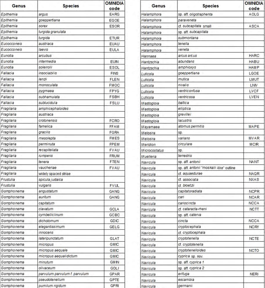

98 98
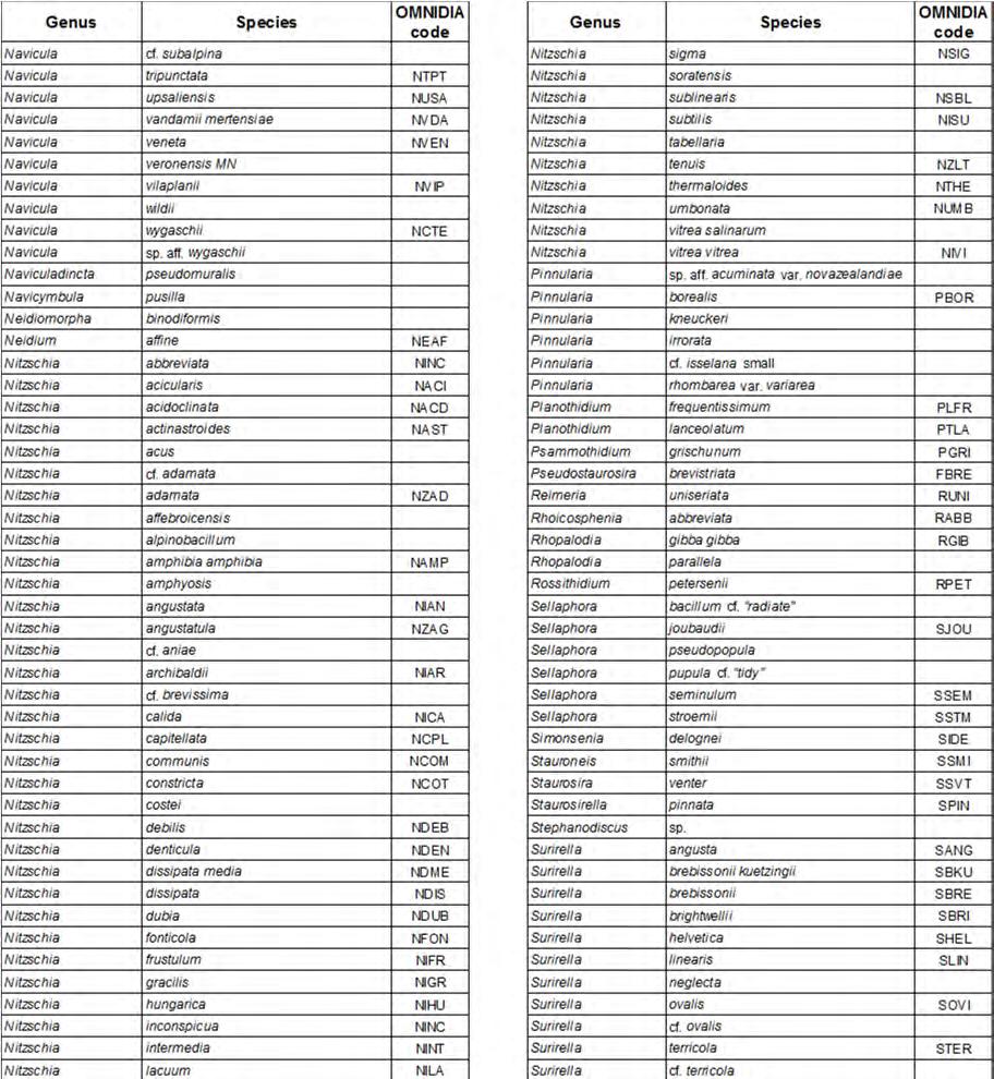

99 99
100 Cyprus: Ecological restoration and fish species re-introduction is required! S. Zogaris (*), N. Koutsikos, S. Giakoumi, Hellenic Center for Marine Research, Institute of Marine Biological Resources and Inland Waters Anavissos, Greece SUMMARY Stream ecosystems in Cyprus are largely degraded by anthropogenic pressures yet a variety of fishes survive there. Here a fish assemblage classification initially depicts seven biotic groups identified from a wide -ranging fish sample database (80 sampled sites in streams). These fish-based ecotypes correspond to natural cool-water upland rivers, mid-sections (frequently near dams), and warm-water coastal lowlands reaches. As expected, in such heterogeneous and anthropogenically degraded conditions non-indigenous species dominate, but native species are surprisingly scarce. Since extinction and local extirpation rates are presumably high, native fish cannot expand to re-colonize isolated basins without human restorative intervention. Here we therefore promote the prospect of utilizing native fish assemblage needs to pursue restoration of flow regimes, natural stream connectivity, science-based fish re-introductions and control of non-indigenous fish species. RIASSUNTO Nonostante gli ecosistemi fluviali del territorio cipriota siano alterati da molteplici pressioni antropiche, essi sostengono una nutrita varietà di specie ittiche. Una classificazione della comunità ittica ha identificato in prima analisi sette gruppi biotici, identificati a partire da un ampio database di circa 80 siti campionati. Tali ecotipi ittici corrispondono a fiumi naturali freddi di montagna, fiumi di medio corso (frequentemente a ridosso di dighe) e tratti caldi di pianure costiere. Come previsto, in tali condizioni eterogenee ed alterate si osserva una dominanza di specie alloctone e, allo stesso tempo, una sorprendentemente scarsa presenza di specie native. Dal momento che l estinzione ed il tasso di eliminazione di determinate specie, almeno a livello locale, è presumibilmente alto, è inverosimile che le specie ittiche native possano espandersi e ricolonizzare bacini isolati in assenza di un intervento umano. In questo contributo gli autori promuovono l idea di utilizzare le necessità delle comunità ittiche native per la ricostituzione dei naturali regimi di flusso, la naturale connettività dei corsi d acqua, la reintroduzione di specie sulla base di indicazioni scientifiche ed il controllo delle specie alloctone. 1. INTRODUCTION Describing fish communities is a basic need for planning ecological restoration (Angermeier & Schlosser, 1995). Most of Cyprus streams are degraded by multiple anthropogenic pressures, including severe disturbances to hydrology, natural habitat and connectivity. Largely as a consequence of this degradation, Cyprus also has very disturbed fish communities relative to what is assumed to have existed. Many stream sites with adequate habitat have no fishes at all (Zogaris et al., 2012). Also, due the insular biogeographical character of the small river basins and the long-term isolation of the island itself, it has been hypothesized that some fish species that may have existed on the island may now be extinct (Zogaris, 2012). At least one species (Salaria fluviatilis) can be presumed extinct until further surveys are completed (Zogaris et al., 2013). Native Mediterranean Toothcarp and the Eel are also now remarkably scarce as reflected in available historical research. Certainly a complete description of the fish communities and research on type-specific reference condition baselines in needed in a conservation context. This report provides a generalization of existing fish assemblages based on cluster analysis classification of many recently sampled sites. Through interpreting the initial fish community patterns we provide expert judgment on potential actions for restoration measures concerning fishes in Cyprus lotic systems. 1. CYPRUS UNIQUE STREAM CONDITIONS 2.1 Study area It is not known if the depauperate freshwater fish fauna of Cyprus is solely a result of biogeographic isolation or a product of extended periods of local aridity, and/or recent anthropogenic aquatic habitat degradation. Today, Cyprus inland freshwater fish fauna includes 22 confirmed species; but only three native freshwater fishes, namely: European eel, Anguilla anguilla (L.), freshwater blenny, Salaria fluviatilis (Asso, 1801) and Mediterranean toothcarp, Aphanius * zogaris@hcmr.gr 100 Notiziario dei Metodi Analitici, 2, 2016

101 fasciatus (Valenciennes, 1821) (Zogaris et al., 2012). At least five euryhaline marine fish such as mugilids, Atherina smelts, and Sea Bass are also known to enter inland waters locally. Cyprus inland waters have a distinctly insular biogeography and geological history, being located on a long-isolated Middle Eastern island within a semi-arid region. Cyprus arose from the sea due to tectonic changes during the Mesozoic (22 million years ago) and has been isolated from the surrounding mainland with the exception for a shortterm connection with the arid coast of western Asia during the Messinian Salinity Crisis, about 5 million years ago (Hadjisterikotis et al., 2000). Cyprus small rivers may have had river-confluences with basins of the adjacent mainland during this short period when the eastern Mediterranean Sea dried-out. However, the over-riding influence on Cyprus biota during the last 4000 years has been humankind. The island has seen many biotic extinctions and introductions; including a mammalian megafaunal collapse (Hadjisterikotis et al., 2000). In recent decades over 110 dams and intensive water management have degraded natural flow regimes in nearly every river. The changes to the rivers, including climate-driven droughts, are so complex that describing biotic reference conditions is especially challenging (Zogaris et al., 2012). Table 1. Description of biotic groups of fish assemblages as defined by the cluster analysis 2.2 Materials and Methods This report is based on recent work done on stream fish research in inland waters with support from the Water Development Department of Cyprus. Electrofishing in freshwaters and fry-nets in brackish waters was used in a standardized application as described in Zogaris et al. (2012). Here we present a biotic assemblage classification of fish-based samples from stream sites. The statistic package Prime 6b is used for cluster analyses. 2.3 Results The sites investigated are fairly representative of the mostly lotic systems located primarily in perennial stream areas of the western half of the island (Fig. 1). The cluster analysis using fish densities present during systematic sampling shows a pattern of 7 groups when arbitrarily cut at 37 % similarity. These groups connect well with the expert-based generic stream abiotic typology (cold-water salmonid, middle sections and river mouths) (Fig. 2). The seven species assemblage types are briefly described in Table 1. Only three of the seven types are dominated by native fish communities; this represents only 19 sites in total (i.e. only 15,2 % of the sites investigated). 2.4 Overwiew Our initial assemblage classification shows that fish create biotic assemblages in Cyprus rivers. Zogaris et al. (2012) provided an initial classification of biotic assemblages using a presence/absence matrix of only 45 sites, including reservoirs. Our work at present reports on sites only within streams and coastal river mouths and includes 80 sites. The patterns among the two classifications are similar. Stream fishes seem to be influenced by the presence of a cold-water salmonid upland area, a mid-section dominated by many dams and associated lacustrinefish communities, and a coastal section where the longitudinal connectivity with the sea and coastal wetland habitats provides important habitat for native species and the influence of marine transient fishes. It is notable that native fishes are remarkably scarce in the island s streams. Although island due have depauperate freshwater ichthyofaunas, even on faroff oceanic islands native fishes exist or several marine species have adapted to inland waters (e.g. Neal et al., 2009). A large temperate Mediterranean island such as Cyprus could have several native species, as are found in Sicily and Sardinia for example. Zogaris et al. (2013) refer to the problem of increased extinction rates on islands and we suggest that severe anthropogenic pressues have occurred on Cyprus may be the cause of recent extirpation and extinctions. Interviews with locals on Cyprus provide evidence for widespread extirpation of fishes and this has been attributed to intensive DDT use (from 1946 to 1978). This complete poisoning of every available watersource during the long summer droughts in order to combat mosquitoes was responsible for the local extirpation of several species, not just fishes, and this has been mentioned many times with convincing evidence for Cyprus (Gucel et al., 2012, Zogaris et al., 2013). 101
 in Cyprus Although there is an urgent need for more historical research to understand the past conditions and the real effects of pressures we must strive to")

102 Figure 1. Sites sampled with fish present (N:80) in Cyprus Although there is an urgent need for more historical research to understand the past conditions and the real effects of pressures we must strive to apply fishes in policy-relevant stream ecosystem restoration measures. 3. CONCLUSIONS What can be recommended based on the current knowledge of the fish assemblages? Below are some restoration approaches that may support both the implementation of the Habitats Directive and the WFD since fish are biotic components of ecosystems that affect both biodiversity and may be used as a biotic quality element for monitoring. Potential approaches Figure 1. Cluster analysis dendrogram showing the site names (as in Zogaris et al., 2012).The cut-off is an arbitrary line at 37 % similarity and this isolated seven biotic groups (also labled in thick horizontal lines at bottom). Abiotic types refer to a simple expert-judgement based generic river typology 102
103 for restoring fish communities include the following: Restoring natural flow regimes. Flow regimes on Cyprus have been degraded by water storage, water abstraction and transfers. Many intermittent areas are presumably artificially intermittent (sensu Skoulikidis et al., 2011) and effects on fishes include local extirpation from summer river desication (Benejam et al., 2010). There is little doubt that fish will benefit from restorative flows and this includes: a) marine fish migration in the lower parts of the river; b) protection of summer refugia for maintaining fish populations, c) helping species overcome low barriers during their movements (e.g. downstream movement of adult eels in autumn); and, d) supporting reophilic cold-water species such as established salmonids in upland river reaches. Maintaining a connection to the sea. Flows must maintain a river s connection to the sea. This does not only involve specific hydrological flow regimes, but also attention should be given to natural-like variation in flow that creates significant sediment movements. Flood pulses in winter can create scoured channels near the sea and these deep pools may connect to underground inflows that maintain long-pool refugia during the summer. Eel elvers are assumed to enter into rivers on Cyprus during late winter and spring, so at this time the freshwater plume produced in the sea presumably provides an important entrance signal for migrating elvers. Removing barriers to fish movement. Barriers are everywhere in Cyprus streams and are known to stall fish movements. Experience has shown in Greece that consecutive barriers can lead to fish extirpations. In studying the effects and restoring this problem, a management scale-specific riverscape approach is required (see Fausch et al., 2002). The effects of barriers must be assessed and on-site restoration applied. Priorities for this are needed in the major rivers and wetlands that host proven eel populations (see Zogaris et al., 2012). Studying and controlling invasive species spread. Non-indigenous species spread primarily due to stocking, accidental and intentional. Dams seem to influence this spread. The issue is one of the most important threats to biodiversity in freshwaters (Dudgeon et al., 2006). Yet we know very little of the effects of species on stream ecosystems or on their biotic interactions in Cyprus. More work on this aspect is needed and controls on intentional and unintentional introductions must be strictly enforced. Scientific re-introduction of native species. There is opportunity on Cyprus for science-based reintroductions (sensu Seddon et al., 2007). Care must be exercised to protect the genetic provenance of populations and avoid any chance of damage to local biota by unintentional spread of non-indigenous species. Again conservation biogeography is important here. In an ecoregional context, Cyprus may be a unique ecoregion as suggested in Zogaris et al. (2012) however its closest biogeographical freshwater region is Southern Anatolia (Abell et al., 2008). One would expect freshwater species that may have inhabited the island in the past to be related to southern Anatolian waters to some degree, so this may be a potential source-area for re-introductions. Today we know of only Salaria fluviatilis and Aphanius fasciatus as natives of the island s inland waters and research should be promoted to explore transplants from native stock areas. If Salaria is confirmed as extinct, a genetic conservation study should decide if stock should be sourced in Southern Anatolia or Crete. Recovery plans for the above two species are required. Furthermore, a plan to protect certain naturalized assemblages (i.e. Brown Trout) or introduce species from within the ecoregion will also be very useful. It is important to explore the philosophical and practical aspects of naturalized introduced species and the issue of anthropogenic fish species assemblage interventions. Not all researchers agree that any nonindigenous species is harmful and should be considered alien for eternity (see Copp et al., 2005). In many parts of Europe naturalized species have become part of the landscape and are treated as established aspects of the ichthyofauna and some are used as environmental indicators (Vandekerkhove & Cardoso, 2010). On Cyprus even naturalized nonindigenous species, such as Brown Trout, have evolved specific fish community characteristics and seem to have persisted in Cyprus upland waters for at least 70 year since their introduction. We should not that species that may have existed in the distant past may have left vacant niches, so their extinction can be reversed only by strategic introductions (Schlaepfer et al., 2011). We must take in a broader view in terms of scale and time, especially in terms of the uncertainties that climatic changes may have on stream systems. Fish are here to stay in Cyprus streams; and our opinion is that humans should intervene to help guide a restorative development of natural assemblages. Our work introduces a very simple assemblage taxonomy which is not comprehensive or validated. It incorporates best available knowledge from a recent multiyear survey of many river basins on the island. A flexible and adaptive framework for assemblage taxonomy is important for conservation. As part of our restoration obligations we should consider the fish assemblage both within the application of the Habitat Directive and WFD. Community ecology approaches may bring a more holistic approach for restoration planning with a deeper appreciation of local natural history. 103
104 ACKNOWLEDGEMENTS A large number of people have contributed in various ways to this work. In the context of community classification and analyses we would particularly like to thank Yorgos Chatzinikolaou, Vassilis Tachos, Leonidas Vardakas, Theocharis Vavalidis, Teresa Ferreira and Pedro Segurado. We are especially grateful to WRC Beaumont for all help field work and to many volunteers who assisted in sampling. Gerald Dorflinger was instrumental for support in field and office. REFERENCES ABELL R., THIEME M.L., REVENGA C., BRYER M., KOTTELAT M., BOGUTSKAYA N., COAD B., MANDRAK N., CONTRERAS-BALDERAS S., BUSSING W., STIASSNY M.L.J., SKELTON P., ALLEN G.R., UNMACK P., NASEKA A., NG R., SINDORF N., ROBERTSON J., ARMIJO E., HIGGINS J.V., HEIBEL T.J., WIKRAMA- NAYAKE E., OLSON D., LÓPEZ H.L., REIS R.E., LUNDBERG J.G., SABAJ-PÉREZ M.H., PETRYET P., Freshwater ecoregions of the world: a new map of biogeographic units for freshwater biodiversity conservation. BioScience, 58 (5): ANGERMEIER P.L., & SCHLOSSER I.J., Conserving aquatic biodiversity: Beyond species and populations. American Fisheries Society Symposium, 17: BENEJAM L., ANGERMEIER P.L., MUNNΙ A., & GARCΝA -BERTHOU E., Assessing effects of water abstraction on fish assemblages in Mediterranean streams. Freshwater Biology, 55 (3): COPP G.H., BIANCO P.G., BOGUTSKAYA N.G., ERŐS T., FALKA I., FERREIRA M.T., FOX M.G., FREYHOF J., GO- ZLAN R.E., GRABOWSKA J., KOVΑČ V., MORENO- AMICH R., NASEKA A.M., PEŇΑZ M., POVŽ M., PRZYBYLSKI M., ROBILLARD M., RUSSELL I.C., STAKĖNAS S., ŠUMER S., VILA-GISPERT A., & WIESNER C., To be, or not to be, a non-native freshwater fish? Journal of Applied Ichthyology, 21 (4): DUDGEON D., ARTHINGTON A.H., GESSNER M.O., KA- WABATA Z.I., KNOWLER D.J., LÉVÊQUE C., NAIMAN R.J., PRIEUR-RICHARD A.H., SOTO D., STIASSNY M.L.J., & SULLIVAN C.A., Freshwater biodiversity: importance, threats, status and conservation challenges. Biological reviews of the Cambridge Philosophical Society, 81 (2): FAUSCH K.D., TORGERSEN C.E., BAXTER C.V., & LI H.W., Landscapes to Riverscapes: Bridging the Gap between Research and Conservation of Stream Fishes. BioScience, 52 (6): GUCEL S., KADIS C., OZDEN O., CHARALAMBIDOU I., LINSTEAD C., FULLER W., KOUNNAMAS C., & OZTURK M., Assessment of biodiversity differences between natural and artificial wetlands in Cyprus. Pakistan Journal of Botany, 44: HADJISTERIKOTIS E., MASALA B., & REESE D.S., The origin and extinction of the large endemic Pleistocene mammals of Cyprus. Biogeographia, 21: NEAL J.W., LILYESTROM C.G., & KWAK T.J., Factors influencing tropical island freshwater fishes: Species, status and management implications in Puerto Rico. Fisheries, 34 (11): SCHLAEPFER M.A., SAX D.F., & OLDEN J.D., The potential conservation value of non-native species. Conservation Biology, 25 (3): SEDDON P.J., ARMSTRONG D.P. & MALONEY R.F., Developing the science of reintroduction biology. Conservation Biology, 21: SKOULIKIDIS N.T., VARDAKAS L., KARAOUZAS I., EKONOMOU A.N., DIMITRIOU E., & ZOGARIS S., Assessing water stress in a Mediterranean lotic system: insights from an artificially intermittent river in Greece. Aquatic Sciences, 73 (4): VANDEKERKHOVE J., & CARDOSO A.C., Alien species and the Water Framework Directive: Questionnaire results. European Commission Joint Research Centre, Institute for Environment and Sustainability. JRC 56502, EUR EN. ISBN ISSN ZOGARIS S., Fishes in the inland waters of Cyprus. H Physis, Bulletin of the Hellenic Society for the Protection of Nature, 135: (In Greek). ZOGARIS S., CHATZINIKOLAOU Y., KOUTSIKOS N., ECONOMOU A.N., OIKONOMOU E., MICHAELIDES G., HADJISTERIKOTIS E., BEAUMONT W.R.C., & FERREIRA M.T., Freshwater fish assemblages in Cyprus with emphasis on the effects of dams. Acta Ichthyologica et Piscatoria, 42 (3): ZOGARIS S., CHATZINIKOLAOU Y., KOUTSIKOS N., OIKONOMOU E., GIAKOUMI S., ECONOMOU A.N., VARDAKAS L., SEGURADO P., & FERREIRA M.T., Assessment of fish assemblages in Cyprus Rivers for the implementation of Directive 2000/60/EC. Specialized Consultancy Services for the Assessment of Fish Assemblages in Cyprus Rivers Implementation of the Directive 2000/60/EC. Final Report of Second Phase of the Project. Hellenic Center for Marine Research - Institute of Marine Biological Resources and Inland Waters / Instituto Superior de Agronomia, Universidade Técnica de Lisboa, Contract YY02/2012 Water Development Department, Republic of Cyprus, 205 pp. ZOGARIS S., MACLAINE J., KOUTSIKOS N., & CHAT- ZINIKOLAOU, Y., Does the River Blenny Salaria fluviatilis (Asso, 1801) still survive on the Mediterranean island of Cyprus? Journal of Natural History, (In Press). 104
105 River macroinvertebrate communities: examples of open issues in Greece K. C. Gritzalis (*), HCMR-IMBRIW Anavyssos, Attica, Greece E. Anastasopoulou, HCMR-IMBRIW Kalamata, Messinia, Greece SUMMARY The purpose of the present work is to highlight serious problems resulting from the classification processes in the five grade quality scale as the EU Directive (2000/60/EC) requires concerning water and especially river ecosystems. We were led in this study upon the ascertainment of an imbalance which appeared at regular intervals by the various research programs being elaborated in Greece. Thus, after an experience which originated from studies conducted in hundreds of sampling stations, in different river types, in all seasons of the year and from contemplating the impact of different types of pollutants and especially the issue of reference conditions, the need for a different approach in the area of classification was revealed. Therefore, using this data and taking into account various parameters such as biodiversity, especially macroinvertebrate fauna, chemical and physico-chemical characteristics and of course hydromorphology, we recognize and focus on the problem, wherein the weak points are being highlighted and subsequently a number of concrete solutions are being proposed. Of course, it should be taken into consideration seriously, that an undisturbed system and specifically an undisturbed river is a difficult concept, since from ancient times the modifications and arrangements of the rivers were a common phenomenon, which was accompanied by a variety of environmental descriptions. This procedure was essential and concerned human health, a regime that also applies today as it is evidenced by the recordings of various environmental conditions and extreme climatic events in conjunction with the various pollution loads. RIASSUNTO Lo scopo del presente contributo è di evidenziare i notevoli problemi risultanti dalle procedure di classificazione in cinque classi, come richiesto dalla Direttiva Quadro sulle Acque (2000/60/EC), per quanto riguarda in particolare gli ecosistemi fluviali. L opportunità per questo studio è stata l osservazione di uno squilibrio, che si presenta ad intervalli regolari, all interno di vari programmi di ricerca sviluppati in Grecia. Dopo un esperienza ottenuta da studi condotti in centinaia di stazioni di campionamento, in diversi tipi fluviali, in tutte le stagioni dell anno, considerando l impatto di diversi tipi di inquinanti e la problematica delle condizioni di riferimento, si è evidenziata la necessità di un differente approccio nell ambito della classificazione. Mediante l utilizzo dei dati così raccolti e considerando svariati parametri quali biodiversità, - in particolare relativa alla fauna macrobentonica -, caratteristiche fisico-chimiche e idromorfologia è stato identificato un problema nel quale sono stati evidenziati alcuni punti deboli e prospettate un numero di soluzioni concrete. In questo ambito, è sicuramente necessario considerare come il concetto di sistema non alterato e specificamente di fiume non alterato sia di difficile inquadramento, dal momento che modificazioni e sistemazioni dei corsi d acqua sono state realizzate sin dai tempi antichi, accompagnate da una varietà di descrizioni delle condizioni ambientali. Tale procedura è stata essenziale ed ha riguardato anche la salute umana, una condizione che risulta valida ancora oggi come evidenziato dall individuazione di diverse condizioni ambientali ed eventi climatici estremi, unitamente a vari carichi di inquinanti. 1. INTRODUCTION The present work provides a status and generally covers a topic strongly connected with the implementation and application of the Water Framework Directive 2000/60/EU in Greece. According to the demands of the later legislation, numerous research projects have been carried out on the Greek freshwater sources, focussing overwhelmingly on the effects of pollution towards the aquatic element. Thus, more or less, all river types, especially those indexed according to the WFD 2000/60/EU at System A and river types RM1, R-M2, R-M4 and R-M5, have been investigated (excluding the non wadable rivers). Concerning the application of the Biological Quality Elements (BQE) as an assessment tool, the most dominant one, which was first studied and then applied, is macroinvertebrate fauna, followed by fish fauna as well as other elements. After the implementation of benthic macroinvertebrates for over three decades it was found that the combination and correlation of them with habitats, has not been adequately studied. It is quite often confirmed that the results from the implementation of several methods concerning the hydromorphological features such as the River Habitat Survey with its environmental management tools of Habitat Quali- * kgritz@hcmr.gr 105 Notiziario dei Metodi Analitici, 2, 2016
 or other similar methods (Buffagni & Kemp, 2002; Buffagni & Erba, 2002), are not identical with the corresponding results from the use of macroinvertebrates or the results deriving from")
. 628/7 BC.")

106 ty Assessment (HQA) and Habitat Modification Score (HMS) (Raven et al., 1998) or other similar methods (Buffagni & Kemp, 2002; Buffagni & Erba, 2002), are not identical with the corresponding results from the use of macroinvertebrates or the results deriving from chemical analysis. Meaning that there is a mismatch observed in terms of classification (Gritzalis & Koussouris, 1999; Vourdoumpa & Gritzalis, 2000; Karaouzas & Gritzalis, 2002). In particular, strongly modified parts of rivers, with excellent chemical quality, are being classified as 'bad' due to poor and limited variety of habitats (Fig. 1; Fig. 2). 628/7 BC. This ancient Greek colony is closely related to Belice (=Hypsas River in ancient Greek) and Modione Rivers (=Selinus River in ancient Greek). During this era, the inhabitants of Selinus City were afflicted by a pestilence from the marshy-type landscape. This situation wiped out the Selinuntines and caused dystocia for women. A solution to this problem, regarding human health, was suggested by the Greek pre-socratic philosopher Empedocles (ca BC), whereby this harmful situation was resolved by structuring the appropriate drainage works and performing modification constructions (Gritzalis, 2008). Figure 1. Vosvozis River (Rodopi, Thrace) various modifications; moderate water quality; very poor benthic fauna Figure 2. Nedon River (Kalamata City, Messinia, Peloponnese), a typical case of high water quality and extremely poor benthic fauna, (only 3-4 species), in a heavily modified river corridor Thus in Greece it remains a necessity to develop an integrated system for the estimation and classification of specific rivers, which will be based on the results from the studies concerning the relationships between BQE s, hydromorphological and chemical (water and sediment) analysis at a microhabitat level. 2. BENTHIC MACROINVERTEBRATE DIVERSITY & PHYSICAL CHARACTER OF THE RIVER 2.1 The physical character and causes of modifications at the rivers in the antiquity The City of Selinus (Selinunte =Italian) was one of the most important ancient Greek colonies in Sicily (Italy) Figure 3. Louros R. (Preveza, Epirus), a modification from the antiquity (Roman Aqueduct) The Peloponnesian rivers in Greece have been well studied and described according to the ancient Greek literature (Spiro, 1903). To the later, a significant contribution originates also from the Latin authors, since there are significant remains from the Roman era concerning the effects on the riverine systems (Fig. 3). Thus, according to the Latin literature, the eminent Roman poet Vergilius (BC 70-19), states for the Alpheios R. (Peloponnese) that...confunditur Alpheo rursuque discedit... Additionally, he describes the riparian vegetation of the river which was covered by laurels (Laurus nobilis L.). Another significant river of Peloponnese (Evrotas R.) is also mentioned by the Latins. The widely known Publius Ovidius Naso (20 March 43 BC AD 17/18), for his excellent contribution to the letters, characterizes Evrotas R. as chilly...frigidus..., also another Roman poet, Statius (AD ca 45-96) states...et asper Evrotas..., focusing on the turbulent character of the specific Lakedaimonian river, while at the same time Cicero mentions in his work De inventione concerning the flooding events of Evrotas River. In the extracts given by the Argives, Evrotas River, is referred to as:...olorifer... ( Taygetique phalanx et oloriferi Eurotae dura manus... ), a fact which reveals that the area could be regarded as an ideal stagnant landscape for swans (Cygnus spp.). The myrtles (Myrtus communis L.) according to Catullus (Roman poet, ca BC) were part of the riparian flora of the river. Nowadays, the rich vegetation at Evrotas Channel is dominated by the species Arundo donax L., a status which was more or less similar to the one during antiquity, as it is referred by many ancient Greek and Latin authors e. g. Pausanias, Callimachus, Solinus, Pomponius 106
, due to the presence of the aquatic and helophyte vegetation")

107 Mela, Valerius Provos etc. The later descriptions contribute to the origin of the name Evrotas which probably derived from the ancient Greek word evros (=mould), due to the presence of the aquatic and helophyte vegetation which appeared during the period of reduced water quantity. Generally, the lacustrine character of the ancient landscape of Sparta is also mentioned by various other researchers (Katahoritis,1905; Sakellariou, 1998; Raftopoulou, 2000; Gritzalis, 2008). 2.3 Results and discussion After having study more than 280 sampling stations in all seasons and especially during spring, summer and autumn, it was ascertained that HQA & HMS were incompatible with BQE, particularly macroinvertebrates, as well as with the chemical status of water. As mentioned above, the amendment of rivers is not something new, but consists part of organized societies since antiquity. This certainly intends to protect human health, as evidenced by the interest of ancient Greeks and Romans towards the environmental characterization of surface runoff which is demonstrated by the collection of information related to quality, physicochemical descriptions and extreme weather conditions. Of course nowadays, especially in the EU, the appropriate instructions have been issued, that highlight the obligations of the member states towards human health which is threatened both by various pollutants and by disastrous floods. Under these statements as well as from our experience from the data collected in Greece it is considered a necessity to adopt a different approach in order to highlight the actual problem that is, to protect human health from environmental degradation but at the same time the authorities to estimate the real situation at a specific segment of the river and to avoid the specification by an expert judgment approach. In these remarks mentioned above, the following summarized cases are advocating which derived from the elaboration of several research programs: Biodiversity numerically may be identical at a sampling station prescribed as high with a station prescribed as bad, also both stations could have zero HMS, similar high HQA values, but a tremendous difference may occur in the composition of the assemblages concerning the sensitive macroinvertebrate taxa. Sampling stations with very high HQA values, zero HMS values, almost no contaminants but with a recorded reduced biodiversity due to the natural existence of sulfur-bacteria Fig. 4, or ferrobacteria. High water quality, but fluctuation in the flood area due to the presence of a hydroelectric dam, something that has as a consequence the switching of the quantity and quality of habitats leading to the reduction of macroinvertebrates biocommunity (Fig. 5), while flow alternations contribute to this phenomenon. In certain cases, (e.g. Samothrace island N. Aege- Figure 4. Typical sampling station with sulfurbacteria (SW Thessaly ) an sea Greece), the water quality is excellent, the HMS is 0, the HQA is > 97, the rivers however did not have fish fauna due to natural causes. Also in Rhodes island (S. Aegean sea), the only fish species present in the rivers is Ladigesocypris ghigii species, a fact that raises concerns about the classification of the rivers (Gritzalis, 2006). Regarding flora, large variations were found in the correlation of habitat and abundance between rivers in Northern and Southern Greece due to temperature and flood regime. The same phenomenon is also observed during the same season and especially from the end of spring to the end of summer between upland and lowland rivers which also belong at the same type (R-M1, R-M2 etc). At almost all stations with emerging flora, the 85% of macroinvertebrates is found at an adult form Also the following phenomenon is often observed, the chemical classification to be stable (i.e. high), the same to apply for HQA and HMS, but an alteration in the bio-community to be recorded, apparently due to the biological cycle of benthic macroinvertebrates. It was also found, at pristine sites, after taking into account all the factors and the criteria regarding the definition of reference conditions (Reynoldson & Wright, 2000; Wallin et al., 2003; Nijboer et al., 2004) a disharmony to exist between HQA and macroinvertebrates. Namely, low rating for HQA, Figure 5. Fluctuations of the water surface due to a hydroelectric power plant (Ladon R., Peloponnese) 107
108 and high biodiversity, especially regarding EPT (Ephemeroptera, Trichoptera and Plecoptera) taxa. 3. CONCLUSIONS Therefore, in summary, we reached the following conclusions recommendations: The amendments - pollutants and environmental approaches are not only a current problem, but they have been identified since antiquity The regime in Greece relating to open issues on macroinvertebrates is a fact, as it is demonstrated from the information provided above. Although several institutions have started to deal with these topics, during the last 25 years, the data is enough; however it is not such as being in other European countries. Multihabitat approach should be applied more extensively. Through a jointed European project strong evidence should be highlighted among BQE, chemistry and hydromorphological characteristics so as to avoid misconceptions concerning ecological quality, especially to data administrators that do not have a direct view of the study area. ACKNOWLEDGEMENTS The authors would like to thank all those colleagues who participated in these studies. We are pleased to acknowledge the colleagues across Europe as such studies reflect collaborative research. This paper also was made possible by grants from the E.U. and the Greek General Secretariat of Research & Technology, Ministry of Development (AQEM & STAR) and from the funds of Prefecture of Messinia, Municipalities of Kalamata, Messini, Oichalia & Triphylia for the implementation of the Research Project: 847. REFERENCES ALBA-TERCEDOR, J. & SÁNCHEZ-ORTEGA A., Un metodo rapido y simple para evoluar le calidad biologica de las aguas corrientes basado en el de Hellawell (1978). Limnetica 4: AQEM Consortium, Manual for the application of the AQEM method. A comprehensive method to assess European streams using macroinvertebrates, developed for the purpose of Water Framework Directive. Version 1.0, February ARMITAGE, P. D., MOSS D., WRIGHT J. F., FURSE M. T., The performance of a new biological water quality score system based on macroinvertebrates over a wide range of unpolluted running-water sites. Water Res. 17: BARBOUR, M. T. & YODER C. O., The multimetric approach to bioassessment, as used in the United States of America. In Assessing the biological quality of fresh waters: RIVPACS and other techniques. Wright, J. F., D. W. Sutcliffe, & M. T. Furse (eds): p Freshwat. Biol. Ass., Ambleside. BUFFAGNI, A. & ERBA S., Guidance for the assessment of Hydromorphological features of rivers within the STAR Project ( BUFFAGNI, A. & KEMP J., Looking beyond the shores of the United Kingdom: addenda for the application of River Habitat Survey in Southern European rivers. J. Limnol., 61(2): DE PAUW N. & VANHOOREN G., Method for biological quality assessment of watercourses in Belgium. Hydrobiologia 100: DIRECTIVE 2000/60/EC of the European Parliament & of the Council of 23 October 2000 establishing a framework for Community action in the field of water policy. Official Journal of the European Communities L 327, : 1-72 DIRECTIVE 2007/60/EC of the European Parliament & of the Council (23 October 2007) on the assessment and management of flood risks.official Journal of the European Union, L 288/ GRITZALIS, K. C. & KOUSSOURIS T. S. Quality indices in habitats of technical works and natural flows. 6th International Conference on Environmental Science & Technology. August 30 th to September 2 nd, 1999, Pythagorion, Samos island, Greece. Proceedings, Vol., B, pp GRITZALIS, K. C., Biological Monitoring of Mediterranean Rivers with Special Reference to Greece. pp In: Water Quality Measurement Series. Biological Monitoring of Rivers. Applications and Perspectives. Ziglio, G., M. Siligardi & G. Flaim (eds). John Wiley & Sons Ltd, Chichester, West Sussex, England, GRITZALIS K., Surface water modifications and human health protection from antiquity to present. Study of various cases with emphasis to Evrotas River, (SE Peloponnese), Greece. Addendum al II volume di Analecta Historico Medica, GRITZALIS K., 2013 (Ed.): Research Project 847: "Three year Monitoring of the Quality and Assessment of the Ecological Status of the Messinian Rivers (SW Peloponnese, Greece), Pamisos, Aris, Ligdou, Epis, Karias, Tzanes-Polylimnio, Maurozoumena, Despotis, Mourtia, Arkadikos, Neda & Velika" Technical Report, Publ.: HCMR, Anavyssos, Greece. JÁIMEZ-CUÉLLAR, P., VIVAS S., BONADA N., ROBLES S., MELLADO A., ÁLVAREZ M., AVILÉS J., CASAS J., ORTEGA M., PARDO I., PRAT N., RIERADEVALL M., SÁINZ-CANTERO C. E., SÁNCHEZ-ORTEGA A., SUÁREZ L., TORO M., VIDAL-ABARCA R., ZAMORA-MUÑOZ C. & ALBA-TERCEDOR J., Protocolo GUADALMED 108
109 (PRECE). Limnetica 21(3-4): KARAOUZAS, I. D. & GRITZALIS K. C., The effects of a modified river on the biodiversity and ecological characteristics on the benthic macroinvertebrate fauna (Pamisos River, Peloponnese, Greece). Proceedings of the International Conference. Joint Research Center. Sustainability of Aquatic Ecosystems Science in support of European Water Policies. Stresa, Lago Maggiore, Italy. p KATAHORITIS, A., The Evrotas (in Greek). In: Spartiatikon Imerologion. Sparta, Greece. Issue 6 th, pp LASCHOU S. Identifying Reference Conditions and Development of a Nutrient Classification System for the Assessment of the Chemical-physico-chemical status of Greek rivers. Master Thesis, National & Kapodistrian University of Athens-HCMR, Athens, Greece, NIJBOER, R. C., JOHNSON R. K., VERDONSCHOT P. F. M., SOMMERHÄUSER M. & BUFFAGNI A., Establishing reference conditions for European streams. In Hering, D., P. F. M. Verdonschot, O. Moog & L. Sandin (eds), Integrated Assessment of Running Waters in Europe. Kluwer Academic Publishers, The Netherlands. Hydrobiologia 516: PINTO, P., ROSADO J., MORAIS M. & ANTUNES I., Assessment methodology for southern siliceous basins in Portugal. In Hering, D., P. F. M. Verdonschot, O. Moog & L. Sandin (eds), Integrated Assessment of Running Waters in Europe. Kluwer Academic Publishers, The Netherlands. Hydrobiologia 516: RAFTOPOULOU, ST. The water in Lakonia. Lakes, Rivers and Fountains in the Antiquity (in Greek). In: Lakonikon Imerologion. Publ.: Idiomorfi, 2000, Sparta, Greece. RAVEN, P. J., HOLMES N. T., DAWSON F. H., FOX P. J. A., EVERARD M., FOZZARD I. R. & ROUEN K. J., River Habitat Quality: the physical character of rivers and streams in the UK and isle of Man. River Habitat Survey Report No 2. Environment Agency. Research Project 847: "Three year Monitoring of the Quality and Assessment of the Ecological Status of the Messinian Rivers (SW Peloponnese, Greece), Pamisos, Aris, Ligdou, Epis, Karias, Tzanes-Polylimnio, Maurozoumena, Despotis, Mourtia, Arkadikos, Neda & Velika". Research Project AQEM: The development and testing of an integrated assessment system for the ecological quality of streams and rivers throughout Europe using benthic macroinvertebrates (AQEM). [EVK1/CT99/00027]. Research Project STAR: Standardisation of river classifications: Framework method for calibrating different biological survey results against ecological quality classifications to be developed for the Water Framework Directive [EVK ]. REYNOLDSON, T. B. & WRIGHT J. F., The reference condition: problems and solutions. In Assessing the biological quality of freshwaters: RIVPACS and other techniques. Wright, J. F., D. W. Sutcliffe, & M. T. Furse (eds): p Freshw. Biol. Ass., Ambleside. SAKELLARIOU A. (1998). Le nom d Eurotas dans la literature latine (in Greek). Lakonikai Spoudai, vol. 14, SKOULIKIDIS N., AMAXIDIS Y., BERTAHAS I., LASCHOU S., GRITZALIS K. (2006). Analysis of factors driving stream water composition and synthesis of management tools A case study on small/medium Greek catchments. The Science of the Total Environment, 362: SKOULIKIDIS N.T., GRITZALIS K.C., KOUVARDA T., BUFFAGNI A. (2004). The development of an ecological quality assessment and classification system for Greek running waters based on benthic macroinvertebrates. In Hering, D., P. F. M. Verdonschot, O. Moog & L. Sandin (eds), Integrated Assessment of Running Waters in Europe. Kluwer Academic Publishers, The Netherlands. Hydrobiologia 516: SKRIVER J., FRIBERG N., KIRKEGAARD J. (2000). Biological assessment of running waters in Denmark: introduction of the Danish Stream Fauna Index (DSFI). Verh. Internat. Limnol. 27: SOLIMINI A., GULIA G.P., MONFRINOTTI M., CARCHINI G. (2000). Performance of different biotic indices and sampling methods in assessing water quality in the lowland stretch of the Tiber River. In Jungwirth, M., S. Muhar & S. Schmutz (eds), Assessing the Ecological Integrity of Running Waters. Kluwer Academic Publishers, The Netherlands. Hydrobiologia 422/423: SPIRO F. (1903). Pausanias, Graeciae descriptio. Leipzig: Teubner. VOURDOUMPA Α. S., GRITZALIS K. C. (2000). Influence of engineering works and controlled river discharge to the use of Biotic Indices. Proceedings of the 6 th Hellenic Symposium on Oceanography & Fisheries. Chios, Greece Vol. II, p (in Greek with English abstract). WALLIN M., WIEDERHOLM T., JOHNSON R. K. (2003). Guidance on establishing reference conditions and ecological status class boundaries for inland surface waters. CIS Working Group 2.3 REFCOND 7 th Version. 109


110 , 2, 2016 Notiziario dei Metodi Analitici & IRSA News Pubblicazione quadrimestrale telematica dell Istituto di Ricerca sulle Acque del Consiglio Nazionale delle Ricerche ISSN X Autorizzazione Tribunale di Tivoli n 5/2015 Direzione e Redazione Istituto di Ricerca sulle Acque, Area della Ricerca RM1, Montelibretti, via Salaria km C.P Monterotondo (RM) Telefono: Fax: notiziario@irsa.cnr.it Direttore responsabile Giuseppe Mascolo Comitato di Redazione L. Campanella, L. Guzzella, S. Polesello, L. Patrolecco, S. Valsecchi Segreteria di Redazione S. Ghergo 110
Giornata celebrativa per il ventennale del Programma LIFE Università degli Studi di Brescia 25 maggio 2012
 Premesse, obiettivi e struttura generale del progetto INHABIT: importanza dell habitat nella definizione dello stato ecologico in fiumi e laghi del Sud Europa Giornata celebrativa per il ventennale del
INHABIT. L applicazione in Italia del Lake Habitat Survey: criticità e potenzialità. Sviluppi futuri
 INHABIT Local hydro-morphology, habitat and RBMPs: new measures to improve ecological quality in L applicazione in Italia del Lake Habitat Survey: criticità e potenzialità. Sviluppi futuri www.life-inhabit.it
L'implementazione della Water Framework Directive e il contributo delle ricerche a lungo termine nei siti lacustri della rete LTER-Italia.
 L'implementazione della Water Framework Directive e il contributo delle ricerche a lungo termine nei siti lacustri della rete LTER-Italia. G. Morabito & A. Marchetto CNR Istituto per lo Studio degli Ecosistemi
Incontro di consultazione pubblica Venezia, 6 luglio 2017
 Inquadramento norma-vo europeo: le linee guida europee sull ecological flow Il conceao di deflusso ecologico in Europa A Blueprint to safeguard Europe s water resources, 2012 (Piano per la salvaguardia
Il percorso del Piano di Gestione del distretto idrografico del fiume Po al 2015 e le sue criticità
 2 ciclo di pianificazione 2015-2021 Workshop della Rete Ambientale I Piani di Gestione dei distretti idrografici e la qualità del corpo idrico Roma, 15 settembre 2014 Il percorso del Piano di Gestione
CORPI IDRICI: STATO E OBIETTIVI. II Forum di informazione pubblica Milano, 17 settembre 2009
 Progetto di Piano Elaborato ai sensi dell art. 13 della Direttiva 2000/60 CE e dell art. 117 del D.Lgs. 152/06 e dell art. 1, comma 3 bis della L.13/09 CORPI IDRICI: STATO E OBIETTIVI II Forum di informazione
Progetto INHABIT Lo stato dell implementazione della WFD in Sardegna quadro conoscitivo e necessità di approfondimento
 Presidenza Direzione generale agenzia regionale del distretto idrografico della Sardegna Servizio tutela e gestione delle risorse idriche, vigilanza sui servizi idrici e gestione delle siccità Progetto
Milano, 23 aprile 2009
 Milano, 23 aprile 2009 Il Piano di gestione del distretto idrografico del fiume Po via Garibaldi, 75-43100 Parma - tel. 0521 2761 www.adbpo.it - partecipo@adbpo.it Piano distrettuale di gestione delle
Reggio Emilia, 8 maggio 2009
 Reggio Emilia, 8 maggio 2009 via Garibaldi, 75-43100 Parma - tel. 0521 2761 www.adbpo.it - partecipo@adbpo.it Piano distrettuale di gestione delle acque Direttiva quadro sulle acque 2000/60/CE (DQA) D.
Analisi idrologica e morfologica: stato dell arte e prospettive
 Analisi idrologica e morfologica: stato dell arte e prospettive Martina Bussettini Istituto Superiore per la Protezione e la Ricerca Ambientale (ISPRA) Italian National Institute for Environmental Protection
Monitoraggio. Incontro tematico per la partecipazione pubblica a supporto dell elaborazione elaborazione del PBI. Parma, 6 luglio 2011
 Monitoraggio Incontro tematico per la partecipazione pubblica a supporto dell elaborazione elaborazione del PBI Parma, 6 luglio 2011 via Giuseppe Garibaldi, 75-43121 Parma - tel. 0521 2761 www.adbpo.it
IL MONITORAGGIO DELLE ACQUE METADATI
 IL MONITORAGGIO DELLE ACQUE METADATI Introduzione... 2 Area Tematica: Acqua superficiale Corsi d acqua... 3 Diatomee... 3 LIMeco... 4 Macrobenthos... 5 Macrofite... 6 tato Ecologico... 7 Area Tematica:
Invaso Trinità (TP): prima classificazione dello stato ecologico in base al DM n. 260/2010.
: prima classificazione dello stato ecologico in base al DM n. 260/2010.") Invaso Trinità (TP): prima classificazione dello stato ecologico in base al DM n. 260/. Il recente Regolamento recante i criteri tecnici per la classificazione dello stato dei corpi idrici superficiali,
Invaso Trinità (TP): prima classificazione dello stato ecologico in base al DM n. 260/. Il recente Regolamento recante i criteri tecnici per la classificazione dello stato dei corpi idrici superficiali,
INDICE. Bacino dei fiumi della pianura tra Livenza e Piave I
 Bacino dei fiumi della pianura tra Livenza e Piave I INDICE 4 - RETI DI MONITORAGGIO ISTITUITE AI FINI DELL ARTICOLO 8 E DELL ALLEGATO V DELLA DIRETTIVA 2000/60/CE E STATO DELLE ACQUE SUPERFICIALI, DELLE
La pianificazione di settore nella Regione Autonoma Friuli Venezia Giulia: elementi di coerenza con il Piano di Gestione
 La pianificazione di settore nella Regione Autonoma Friuli Venezia Giulia: elementi di coerenza con il Piano di Gestione Il Piano di tutela delle acque SCOPO Costituisce uno specifico piano di settore
PROGRAMMA CORSO ECOLOGIA APPLICATA Dott. Fabrizio Scialanca - Limnologo
 PROGRAMMA CORSO ECOLOGIA APPLICATA Dott. Fabrizio Scialanca - Limnologo 1. CENNI DI ECOLOGIA I principali cicli biogeochimici Le catene trofiche 2. FATTORI ED ELEMENTI CLIMATICI Caratteristiche chimico-fisiche
Indice. Approccio concettuale. Procedura operativa
 Introduzione... pag. 1 Parte A Approccio concettuale 1 Tipi di monitoraggio... pag. 13 1.1 Stato attuale... pag. 13 2 Monitoraggio operativo finalizzato... pag. 19 2.1 Obiettivi del monitoraggio... pag.
Un nuovo indice per valutare la qualità ecologica dei laghi attraverso gli invertebrati bentonici: validazione con i risultati del Progetto INHABIT
 Un nuovo indice per valutare la qualità ecologica dei laghi attraverso gli invertebrati bentonici: validazione con i risultati del Progetto INHABIT Zaupa Silvia & Boggero Angela CNR-ISE a.boggero@ise.cnr.it
I corpi idrici tipizzati secondo la direttiva quadro in materia di acque (2000/60/CE)
") DATI E INFORMAZIONI DI INTERESSE AMBIENTALE E TERRITORIALE Prima sessione: DATI E INFORMAZIONI INERENTI LO STATO DELL AMBIENTE I corpi idrici tipizzati secondo la direttiva quadro in materia di acque (2000/60/CE)
DATI E INFORMAZIONI DI INTERESSE AMBIENTALE E TERRITORIALE Prima sessione: DATI E INFORMAZIONI INERENTI LO STATO DELL AMBIENTE I corpi idrici tipizzati secondo la direttiva quadro in materia di acque (2000/60/CE)
Prospettive per il biomonitoraggio dei fiumi
 Pietro Genoni DM Ambiente 260/2010: la fine di una fatica o l avvio di un cammino? Bologna, 16 maggio 2011 Working Group Ecological Status (ECOSTAT) Compiti del WG 2010-2012 (3) Classificazione ecologica
ALMA MATER STUDIORUM UNIVERSITÀ DEGLI STUDI DI BOLOGNA FACOLTÀ DI SCIENZE MATEMATICHE, FISICHE E NATURALI
 ALMA MATER STUDIORUM UNIVERSITÀ DEGLI STUDI DI BOLOGNA FACOLTÀ DI SCIENZE MATEMATICHE, FISICHE E NATURALI ASPETTI ECOLOGICI E NORMATIVA PER IL CONTROLLO E MONITORAGGIO DELLE ACQUE CORRENTI: CONFRONTO TRA
INDICE. Bacino dello Slizza I
 Bacino dello Slizza I INDICE 5.1. OBIETTIVI AMBIENTALI PER LE ACQUE SUPERFICIALI... 1 5.1.2. Proroga dei termini fissati dall articolo 4, comma 1, della Direttiva 2000/60/CE allo scopo del graduale conseguimento
Dalla qualità delle acque alla funzionalità ecologica
 Corso sulla riqualificazione dei corsi d acqua e tecniche di ingegneria naturalistica - Provincia di Milano Dalla qualità delle acque alla funzionalità ecologica L OBIETTIVO DELLA DIRETTIVA ACQUE 2000/60
Glossario e architettura del piano
 Ing. Andrea Braidot dei fiumi Isonzo, Tagliamento, Livenza, Piave, Brenta- Bacchiglione dei fiumi Isonzo, Tagliamento, del fiume Adige Glossario essenziale del piano dei fiumi Isonzo, Tagliamento, del
LINEE GUIDA PER I PIANI DI ADEGUAMENTO
 LINEE GUIDA PER I PIANI DI ADEGUAMENTO Valido per il CRITERIO n. 1 e 2 (da consegnare entro il 7 agosto 2006) 1. DESCRIZIONE DELLA DERIVAZIONE IN ATTO 1.1 Inquadramento geografico della derivazione in
Deflusso minimo vitale: il caso del Friuli Venezia Giulia. G. Favrin, V. Stocca, G. Mattassi
 Workshop: «Dal DMV al flusso ecologico: stato dell arte nel distretto padano ed esigenze future di rilevanza europea» Deflusso minimo vitale: il caso del Friuli Venezia Giulia G. Favrin, V. Stocca, G.
Revisione delle zone vulnerabili ai nitrati di origine agricola Acque superficiali
 Workshop Stato di avanzamento dei lavori per la revisione delle zone vulnerabili Milano, 13 febbraio 2014 Revisione delle zone vulnerabili ai nitrati di origine agricola Acque superficiali ARPA LOMBARDIA
Ampliamento parco a tema Miragica verifica di assoggettabilità al V.I.A.
 PIANO DI LAVORO La presente relazione intende illustrare il Piano di lavoro per la redazione dei lavori di AMPLIAMENTO DEL PARCO A TEMA MIRAGICA nel comune di Molfetta, da realizzare nell area identificata
nni Callegari, Nicola Cantasano, Raffaele Froio, Nicola Ricca, Antonella Veltri, Ernesto Infusino*
 I/MEMORIE IDRAULICA FLUVIALE. nni Callegari, Nicola Cantasano, Raffaele Froio, Nicola Ricca, Antonella Veltri, Ernesto Infusino* DICE DI FUNZIONALITA' FLUVIALE (I.F.F.) IN CALABRIA. caso del fiume Crati
Gestione sostenibile delle risorse idriche superficiali e sotterranee INQUINAMENTO DELLE ACQUE PROVOCATO DA NITRATI DI ORIGINE AGRICOLA
 INQUINAMENTO DELLE ACQUE PROVOCATO DA NITRATI DI ORIGINE AGRICOLA Uno dei temi afferenti alla problematica della Gestione sostenibile delle acque sotterranee e di superficie è quello dell Inquinamento
Modellistica numerica avanzata a supporto dell idroecologia Scenari di impatto sulla qualità delle acque
 Modellistica numerica avanzata a supporto dell idroecologia Scenari di impatto sulla qualità delle acque Luca Dutto - Hydrodata S.p.A. Mauro Porcelli - Ente Parco Nazionale del Circeo Torino, 14-15 Ottobre
Recenti sviluppi nella classificazione ecologica dei laghi tramite i macroinvertebrati
 Recenti sviluppi nella classificazione ecologica dei laghi tramite i macroinvertebrati Boggero Angela CNR ISE a.boggero@ise.cnr.it http://www.ise.cnr.it/ AQUAE VENEZIA 2015 Research as a tool for freshwater
Zaupa S.! "# Boggero A. Rossaro B. Bettinetti R. Buscarinu P. Sesia E.
 Zaupa S.! "# Boggero A. Rossaro B. Bettinetti R. Buscarinu P. Sesia E. Il progetto finanziato per l implementazione della Direttiva 2000/60/CE ha lo scopo di definire lo stato ecologico e il potenziale
SOMMARIO 1 MONITORAGGIO...2
 SOMMARIO 1...2 1.1 MATRICE ARIA... 4 1.2 MATRICE ACQUA... 5 1.3 MATRICE SUOLO E SOTTOSUOLO... 6 1.4 MATRICE FLORA E FAUNA... 7 1.5 MATRICE BIODIVERSITÁ... 8 1.6 MATRICE POPOLAZIONE... 10 1.7 MATRICE BENI
Incontro regionale sui Piani di Gestione
 Incontro regionale sui Piani di Gestione Genova,, 21 ottobre 2009 Il Piano di Gestione dell Appennino Settentrionale Marcello Brugioni Autorità di Bacino del Fiume Arno La direttiva 2000/60 L uso della
Le misure del Piano di Gestione delle Acque per i corpi idrici in relazione all uso idroelettrico
 Le misure del Piano di Gestione delle Acque per i corpi idrici in relazione all uso idroelettrico Andrea Braidot Autorità di Bacino fiumi Alto Adriatico Tolmezzo, 5 maggio 2015 Altre misure di base (art.
LIFE. Dott. Marco Zanetti (biologo) Martedì 17 maggio Azione. . Applicazione dell Indice di Funzionalità Fluviale (I.F.F.) sul Fiume Sile.
 Martedì 17 maggio Azione. . Applicazione dell Indice di Funzionalità Fluviale (I.F.F.) sul Fiume Sile.") Bioprogramm S.C. LIFE 14/NAT/IT/000809 River functionality index as planning instrument for a good governance of Sile s ecosystem A1 Azione. Applicazione dell Indice di Funzionalità Fluviale (I.F.F.) sul
Bioprogramm S.C. LIFE 14/NAT/IT/000809 River functionality index as planning instrument for a good governance of Sile s ecosystem A1 Azione. Applicazione dell Indice di Funzionalità Fluviale (I.F.F.) sul
Complementarietà e sviluppo di sinergie con il programma per l ambiente e l azione per il clima LIFE a supporto dei PSR 2014/2020
 Complementarietà e sviluppo di sinergie con il programma per l ambiente e l azione per il clima LIFE a supporto dei PSR 2014/2020 1. Istituzione proponente Consiglio per la ricerca in agricoltura e l analisi
Elementi idromorfologici: indice di alterazione del regime idrologico (IARI)
") Direttiva 2000/60/CE: Struttura delle reti e dei programmi di monitoraggio sui corsi d acqua Indici di classificazione dello stato di qualità Elementi idromorfologici: indice di alterazione del regime
Direttiva 2000/60/CE: Struttura delle reti e dei programmi di monitoraggio sui corsi d acqua Indici di classificazione dello stato di qualità Elementi idromorfologici: indice di alterazione del regime
Ricerca e innovazione per la governance ambientale
 Ricerca e innovazione per la governance ambientale Le acque marino-costiere e di transizione Anna Maria Cicero ISPRA Istituto Superiore per la Protezione e la Ricerca Ambientale Forum PA, Roma, 18 maggio
Biodiversità, ricchezza tassonomica e stato di qualità ecologica dei corsi d acqua: evoluzione normativa e fatiche italiane
 LXXI Congresso Nazionale dell'unione Zoologica Italiana Palermo, 20 settembre 2010 Biodiversità, ricchezza tassonomica e stato di qualità ecologica dei corsi d acqua: evoluzione normativa e fatiche italiane
UNIVERSITA DEGLI STUDI DI SIENA Facoltà si scienze Matematiche, Fisiche e Naturali Corso di Laurea in Scienze Ambientali Curriculum EcoGeFCo
 UNIVERSITA DEGLI STUDI DI SIENA Facoltà si scienze Matematiche, Fisiche e Naturali Corso di Laurea in Scienze Ambientali Curriculum EcoGeFCo MONITORAGGIO DEI COMPOSTI DELL AZOTO E DEI PARAMETRI CHIMICO-FISICI
Utilizzo dei macroinvertebrati come indicatori biologici della qualità ecologica secondo la Direttiva 2000/60/CE
 Utilizzo dei macroinvertebrati come indicatori biologici della qualità ecologica secondo la Direttiva 2000/60/CE Zaupa Silvia Dottorato di Ricerca in Scienze Ambientali XXV Ciclo Relatore: Prof.ssa Roberta
Incontro di consultazione pubblica Venezia, 6 luglio 2017
 L orientamento distre.uale per la formulazione di una proposta di deflusso ecologico SoggeB isctuzionali coinvolc AdD Regioni e Province Autonome Agenzie di protezione ambientale Tavolo Tecnico Nazionale
L importanza della zona iporreica e dell idromorfologia nella ritenzione dei nutrienti: esperienze condotte nel torrente Curone (LC)
") Presentazione preparata con il contributo Europeo LIFE+ 2008 Programme (European Commission) L importanza della zona iporreica e dell idromorfologia nella ritenzione dei nutrienti: esperienze condotte
Presentazione preparata con il contributo Europeo LIFE+ 2008 Programme (European Commission) L importanza della zona iporreica e dell idromorfologia nella ritenzione dei nutrienti: esperienze condotte
Università degli Studi di Napoli Federico II
 Università degli Studi di Napoli Federico II Dipartimento di Ingegneria Civile, Edile e Ambientale Relatore: Classe delle lauree in Ingegneria Civile e Ambientale, Classe n 35. Corso di Laurea Magistrale
Autorità di bacino del fiume Po
 Analisi e proposte tecnico-scientifiche per la conoscenza e la pianificazione integrata del distretto del fiume Po: presentazione del progetto Rete di Monitoraggio del Po (Re.Mo. del Po) Lunedì, 15 maggio
13 dicembre Descrizione dell attività didattica
 13 dicembre 2007 Descrizione dell attività didattica 13 dicembre 2007 Modulo didattico 3 interventi per le scuole superiori (lezione frontale in aula + uscita di campo + laboratorio) 2 interventi per le
ECONOMIA, SOSTENIBILITÀ E RESILIENZA: VALUTARE LA QUALITÀ DEI SISTEMI LOCALI ALLEGATO: REALIZZARE UN ANALISI SWOT Giulia Pesaro
 n.1 Fondazione Cariplo progetto Capacity building REesilienceLAB http://www.resiliencelab.eu Incontri di formazione Resilienza urbana e territoriale incontri di formazione 1 aprile 2014 APPROCCI E STRUMENTI
IMPATTI INDOTTI SU UN CORSO D ACQUA
 servizio idraulica DERIVAZIONI IDROELETTRICHE: IMPATTI INDOTTI SU UN CORSO D ACQUA Ing. Federica Lippi Malnisio,, 16 giugno 2011 Le filiere dell energia Energia idroelettrica PREMESSA L acqua rappresenta
Gli indirizzi regionali per la gestione della pesca in lombardia
 Gli indirizzi regionali per la gestione della pesca in lombardia Adozione del documento tecnico ai sensi art.8 l.r.12/01 Stefano Agostoni & Nadia Rota Corso di Formazione CISBA La Fauna ittica dei corsi
PARCO NAZIONALE DELLE FORESTE CASENTINESI, MONTE FALTERONA, CAMPIGNA. PIANO del PARCO
 PARCO NAZIONALE DELLE FORESTE CASENTINESI, MONTE FALTERONA, CAMPIGNA PIANO del PARCO Rapporto Ambientale ai fini della Valutazione Ambientale Strategica (VAS): rinvii ai contenuti di cui all Allegato VI
DEFINIZIONE DELL ALGORITMO DI CALCOLO DEL DEFLUSSO MINIMO VITALE IN FRIULI VENEZIA GIULIA
 DEFINIZIONE DELL ALGORITMO DI CALCOLO DEL DEFLUSSO MINIMO VITALE IN FRIULI VENEZIA GIULIA DANIELA IERVOLINO Regione Friuli Venezia Giulia TOLMEZZO 5 maggio 2015 Linee di indirizzo Corsi d acqua/tratti
MEGA Process Oriented & Risk Driven Solution
 MEGA Process Oriented & Risk Driven Solution Solvency 2012 La Roadmap verso la Risk Based Insurance Risk Appetite Framework: una possibile declinazione operativa Agenda dell intervento 5 20 Risk Appetite:
Regione Siciliana PIANO ENERGETICO AMBIENTALE REGIONALE DELLA REGIONE SICILIANA MONITORAGGIO. (Misure adottate in merito al monitoraggio art.
 PIANO ENERGETICO AMBIENTALE REGIONALE DELLA REGIONE SICILIANA MONITORAGGIO (Misure adottate in merito al monitoraggio art. 10) VALUTAZIONE AMBIENTALE STRATEGICA (Dir. 42/2001/CE) 1 SISTEMA DI MONITORAGGIO
UTILIZZO DEGLI ODONATI COME INDICATORI DELLO STATO ECOLOGICO DEI CORSI D ACQUA E STRUMENTO DI MONITORAGGIO DI INTERVENTI DI RIQUALIFICAZIONE FLUVIALE
 2 Convegno italiano sulla riqualificazione fluviale Riqualificazione fluviale e gestione del territorio 6-7 novembre 2012, Bolzano UTILIZZO DEGLI ODONATI COME INDICATORI DELLO STATO ECOLOGICO DEI CORSI
CONTRATTO DI FIUME PER L'ASTICO-TESINA
 PROVINCIA DI VICENZA SERVIZIO BENI AMBIENTALI E RISORSE IDRICHE CONTRATTO DI FIUME PER L'ASTICO-TESINA ELABORATO N. TITOLO SCALA 4 Programma di azione Struttura preliminare CODICE DOCUMENTO 0573SP04 FILE
WORSHOP DAL DMV AL FLUSSO ECOLOGICO:
 WORSHOP DAL DMV AL FLUSSO ECOLOGICO: stato dell arte nel distretto padano ed esigenze future di rilevanza europea Parma, 27 giugno 2013 Situazione Alta densità di derivazioni e alterazione del regime di
Autorità di Bacino del Fiume Arno
 Conferenza Acqua L approccio della Regione Emilia-Romagna nell attuazione della direttiva 2000/60/CE Ravenna, 30 settembre 2009 Il piano di gestione del distretto dell Appennino Settentrionale Marcello
Consorzio Interuniversitario. per l Idrologia.
 Consorzio Interuniversitario per l Idrologia 1 www.cinid.it IL CONSORZIO CONTATTI Sede legale Università degli Studi della Basilicata Via Nazario Sauro, 85 - Potenza (PZ) Ph. (+39) 0971 427 404-406 Mob.
Indagine ecologica. 100 fontanili dall Adda al Ticino sistemi ambientali di connessione per la rete ecologica
 Laura Marziali Fabrizio Stefani Raffaella Balestrini Franco Salerno Istituto di Ricerca sulle Acque UOS Brugherio Via del Mulino 19, 20861 Brugherio (MB) 100 fontanili dall Adda al Ticino sistemi ambientali
L applicazione della WFD alle acque superficiali: punti di forza e di debolezza
 ISTITUTO DI RICERCA SULLE ACQUE Unità Organizzativa di Supporto di Brugherio L applicazione della WFD alle acque superficiali: punti di forza e di debolezza Stefania Erba & Andrea Buffagni erba@irsa.cnr.it
Capitolo 3 Caratterizzazione delle aree protette
 Piano di gestione dei bacini idrografici delle Alpi Orientali Bacino dello slizza Capitolo 3 I INDICE 3. CARATTERIZZAZIONE DELLE AREE PROTETTE... 1 3.1. AREE PER L ESTRAZIONE DI ACQUE DESTINATE AL CONSUMO
AAVV, (1998), Water quality criteria in enviromental management Commission of the European Communities.
, Water quality criteria in enviromental management Commission of the European Communities.") BIBLIOGRAFIA AAVV, (1998), Water quality criteria in enviromental management Commission of the European Communities. AAVV, (2001), Manuale di riqualificazione fluviale C.I.R.F. AAVV, (2002), Applicazione
BIBLIOGRAFIA AAVV, (1998), Water quality criteria in enviromental management Commission of the European Communities. AAVV, (2001), Manuale di riqualificazione fluviale C.I.R.F. AAVV, (2002), Applicazione
I macroinvertebrati dei laghi - 1
 Quaderni del Museo delle Scienze 6/1 I macroinvertebrati dei laghi - 1 tassonomia, ecologia e metodi di studio a cura di Valeria Lencioni Angela Boggero Laura Marziali Bruno Rossaro Trento 2013 Quaderni
Sviluppi del concetto di Rete Ecologica in Italia
 Le reti ecologiche e il livello provinciale di governo del territorio: riflessioni e spunti dopo il primo monitoraggio del panorama nazionale Arch. Serena D Ambrogi Dipartimento Difesa della Natura Servizio
Fasce riparie, habitat e ritenzione dei nutrienti - Potenzialità per la gestione delle acque nei sistemi agrourbani.
 Acqua e resilienza territoriale: costruire il futuro delle aree metropolitane - Milano, 4 luglio 2016 Fasce riparie, habitat e ritenzione dei nutrienti - Potenzialità per la gestione delle acque nei sistemi
sedimenti, realizzando adattamenti morfologici (dimensioni, forma, tracciato,
 CAPITOLO 1 ELEMENTI DI RIQUALIFICAZIONE FLUVIALE In un progetto di gestione e riqualificazione di un corso d acqua la conoscenza delle problematiche e dei processi fisici e biologici, è la base per poter
Docenti: Guido Sali Enrico Chiaradia Ilda Vagge
 Docenti: Guido Sali Enrico Chiaradia Ilda Vagge Obiettivi del laboratorio Il corso si propone di illustrare le metodologie di approccio al tema della riqualificazione di specifici ambiti territoriali (specificatamente
Applicazione dell IFF nel bacino idrografico del Fiume Foglia: l integrazione geologico-geomorfologica nell elaborazione dei modelli interpretativi
 Applicazione dell IFF nel bacino idrografico del Fiume Foglia: l integrazione geologico-geomorfologica nell elaborazione dei modelli interpretativi Dott. ssa Valentina Tiberi* *Dipartimento di Scienze
Definizione di piani operativi di gestione della vegetazione riparia in due siti ad elevato pregio ambientale in Provincia di Trento
 Definizione di piani operativi di gestione della vegetazione riparia in due siti ad elevato pregio ambientale in Provincia di Trento Trentini Giuliano BIOS IS s.r.l.- Firenze Fossi Giordano BIOS IS s.r.l.-
L ITALIA SOSTENIBILE IDEE E AZIONI PER IL FUTURO
 L ITALIA SOSTENIBILE IDEE E AZIONI PER IL FUTURO BOLOGNA 20-21 MAGGIO 2016 C.N.R. AREA DELLA RICERCA DI BOLOGNA Biodiversità e Cambiamenti Climatici proposte operative Roberto Danovaro Università Politecnica
Il monitoraggio dei corsi d acqua: analisi ed influenza sulle prestazioni delle turbine idrauliche
 Il monitoraggio dei corsi d acqua: analisi ed influenza sulle prestazioni delle turbine idrauliche Studio di Ingegneria Dalla Costa ing. Stefano Corso A. Fogazzaro, 202 36100 Vicenza (VI) ITALY Phone:
Università di Trento - Dipartimento di Ingegneria Civile Ambientale e Meccanica. Agenzia Provinciale per la Protezione dell Ambiente
 LINEE GUIDA PER LA DEFINIZIONE DEI CONTENUTI MINIMI DEI PIANI DI MONITORAGGIO RELATIVI ALLA VALUTAZIONE DEGLI EFFETTI DELLE DERIVAZIONI IDRICHE SULLO STATO DI QUALITA DEI CORPI IDRICI Università di Trento
A cosa serve? Perché è richiesto?
 A cosa serve? La conoscenza delle dinamiche relative all uso del suolo è importante per la pianificazione territoriale in quanto consente di leggere lo stato attuale dei luoghi come risultante delle modificazioni
Il risanamento ambientale del lago di Viverone: un obiettivo per la Provincia di Biella, possibilità di utilizzo delle fasce tampone
 Il risanamento ambientale del lago di Viverone: un obiettivo per la Provincia di Biella, possibilità di utilizzo delle fasce tampone Matteo Massara Biella, 28 settembre 2007 Il lago di Viverone è un importante
Repertorio delle informazioni a supporto del processo di riesame e aggiornamento del PdG Po 2015
 Repertorio delle informazioni a supporto del processo di riesame e aggiornamento del PdG Po 2015 All. VII, parti A e B, punto 11 della Direttiva 2000/60/CE e All. 4, parti A e B, punto 11, alla Parte Terza
"GIS e modelli idraulici per l aggiornamento del PAI in area urbana"
 Open Day Perugia 9 luglio 2012 GIS e Modelli Idraulici per il Rischio Idrogeologico "GIS e modelli idraulici per l aggiornamento del PAI in area urbana" Ing. Giorgio Cesari Autorità di bacino del Fiume
CARAVAGGIO: habitat information and indices
 CARAVAGGIO: habitat information and indices Stefania Erba 1, Marcello Cazzola 1, Daniele Demartini 1, 2, David G. Armanini 2, Andrea Buffagni 1 1 CNR-IRSA (Brugherio) 2 Prothea (Milano) Corso di formazione
Il ruolo dell analisi geomorfologica nella valutazione della pericolosità idraulica
 WORKSHOP PERICOLOSITÁ IDRAULICA NEL TERRITORIO MONTANO ITALIANO ED APPLICAZIONE DELLA DIRETTIVA EUROPEA ALLUVIONI Bolzano, 9-10 giugno 2011 Il ruolo dell analisi geomorfologica nella valutazione della
La Pianificazione delle acque Paolo Mancin
 La Pianificazione delle acque Paolo Mancin Modello DPSIR su Acqua : le risposte Lo schema della Direttiva Quadro Acque Piano di Gestione del distretto idrografico del Fiume Po STATO monitoraggi PRESSIONI
Piano di Gestione del fiume Po: riesame e aggiornamento
 2 ciclo di pianificazione 2015-2021 Piano di Gestione del fiume Po: riesame e aggiornamento Usi industriali e idroelettrici Pressioni, misure e prospettive sulla qualità delle acque nel bacino del Po Parma,
IL RUOLO DEL GEOLOGO NEI PROCESSI DI VALUTAZIONE AMBIENTALE
 IL RUOLO DEL GEOLOGO NEI PROCESSI DI VALUTAZIONE AMBIENTALE Corso di Aggiornamento Professionale Viterbo, 24 maggio 2010 - Palazzo della Provincia Prima Sessione Le componenti geologiche nello SIA: ambiente
PIANIFICAZIONE TERRITORIALE E URBANISTICA. La pianificazione sostenibile. III Modulo: Le valutazioni
 M.I.B.AR. MASTER INTERNAZIONALE DI BIOARCHITETTURA PIANIFICAZIONE TERRITORIALE E URBANISTICA La pianificazione sostenibile III Modulo: Le valutazioni Arch. LINO GIORGINI Istituto Nazionale di Bioarchitettura
UNIVERSITA CATTOLICA DEL SACRO CUORE MILANO. Rischio, vulnerabilità e resilienza territoriale: il caso delle province italiane
 UNIVERSITA CATTOLICA DEL SACRO CUORE MILANO Dottorato di ricerca in Politica Economica ciclo XXIV S.S.D: SECS-S/05; ICAR/21; SECS-P/02 Rischio, vulnerabilità e resilienza territoriale: il caso delle province
Pressioni puntuali, diffuse e idromorfologiche determinate dal comparto agricolo sui corpi idrici del Veneto
 Pressioni puntuali, diffuse e idromorfologiche determinate dal comparto agricolo sui corpi idrici del Veneto dei fiumi Isonzo, Tagliamento, del fiume Adige Architettura del piano Il modello DPSIR EEA Environmental
Ravenna 2010 La comunicazione ambientale. La norma ISO 14063: Linee Guida per la Comunicazione Ambientale
 Ing. Alessandra Archetti CESQA Centro Studi Qualità Ambiente CURA Consorzio Universitario di Ricerca Applicata c/o Dipartimento di Processi Chimici dell Ingegneria Università di Padova tel +39 049 8275539/5536
Il connettivo agricolo nella definizione della rete ecologica e il ruolo dei servizi ecosistemici
 25 maggio 2015 Buttrio (UD) villa Florio Francesco Boscutti Maurizia Sigura Il connettivo agricolo nella definizione della rete ecologica e il ruolo dei servizi ecosistemici francesco.boscutti@uniud.it
I piani di gestione di distretto per la tutela e riqualificazione degli ecosistemi fluviali alpini
 I piani di gestione di distretto per la tutela e riqualificazione degli ecosistemi fluviali alpini CIRF Centro Italiano per la Riqualificazione Fluviale Quali aspettative nei confronti dei piani di gestione
L analisi per flussi e il Rendiconto finanziario
 L analisi per flussi e il Rendiconto finanziario Roberto Bandinelli Riccardo Mazzoni Traccia di economia aziendale Il candidato, dopo aver commentato la validità conoscitiva e diagnostica della situazione
Presentazione del progetto Master Adapt
 Adattamento ai cambiamenti climatici: le esperienze e le opportunità dei progetti LIFE in Italia Roma 24 Maggio 2017 Presentazione del progetto Master Adapt Il Progetto individuazione di una metodologia
CORSO DI LAUREA SPECIALISTICA IN ECOLOGIA
 UNIVERSITÀ DEGLI STUDI DI PARMA FACOLTÀ DI SCIENZE MATEMATICHE FISICHE E NATURALI CORSO DI LAUREA SPECIALISTICA IN ECOLOGIA LAUREA SPECIALISTICA DELLA CLASSE 6/S - BIOLOGIA NUOVO ORDINAMENTO DIDATTICO
Affidabilitàdel dato nella classificazione ecologica dei corpi idrici della Regione Piemonte
 Stato ecologico dei fiumi ai sensi della Direttiva 2000/60/CE: valutazione della qualità del dato Affidabilitàdel dato nella classificazione ecologica dei corpi idrici della Regione Piemonte Antonietta
Analisi delle caratteristiche delle acque superficiali nel bacino del fiume Adige: corpi idrici superficiali e condizioni di riferimento
 Analisi delle caratteristiche delle acque superficiali nel bacino del fiume Adige: corpi idrici superficiali e condizioni di riferimento TRENTO Museo tridentino di scienze naturali 17 gennaio 2007 dott.
Gli aspetti di sistemazione idrogeologica e idraulica nel loro rapporto con il PdG Po. Ing. Lorenzo Masoero Geol. Giorgio Gaido
 Gli aspetti di sistemazione idrogeologica e idraulica nel loro rapporto con il PdG Po Ing. Lorenzo Masoero Geol. Giorgio Gaido SCALETTA INTERVENTO principali strumenti di pianificazione ed i loro obiettivi
CORSO DI LAUREA SPECIALISTICA IN ECOLOGIA
 UNIVERSITÀ DEGLI STUDI DI PARMA FACOLTÀ DI SCIENZE MATEMATICHE FISICHE E NATURALI CORSO DI LAUREA SPECIALISTICA IN ECOLOGIA LAUREA SPECIALISTICA DELLA CLASSE 6/S - BIOLOGIA Nuovo ordinamento didattico
UNIVERSITÀ DEGLI STUDI DI NAPOLI FEDERICO II
 UNIVERSITÀ DEGLI STUDI DI NAPOLI FEDERICO II FACOLTA DI INGEGNERIA CORSO DI LAUREA IN INGEGNERIA PER L AMBIENTE ED IL TERRITORIO SINTESI DELL ELABORATO DI TESI VALUTAZIONE DEI TREND DEI NITRATI IN CAMPANIA
Piano Regionale di Tutela Acque
 Piano Regionale di Tutela Acque Fonte normativa: decreto legislativo 3 aprile 2006, n.152 Norme in materia ambientale articolo 121 Strutture coinvolte: Servizio infrastrutture civili e tutela acque dall'inquinamento
INHABIT. Introduzione al progetto INHABIT
 INHABIT Local hydro morphology, habitat and RBMPs: new measures to improve ecological quality in Introduzione al progetto INHABIT www.life inhabit.it CNR-IRSA, RAS, ARPA Piemonte, UniTuscia-DEB A. Buffagni,
WP2/WP6: Approccio multiscala all analisi e valutazione dei processi fluviali: stato idromorfologico dei corsi d acqua
 WP2/WP6: Approccio multiscala all analisi e valutazione dei processi fluviali: stato idromorfologico dei corsi d acqua Massimo Rinaldi Università di Firenze WP2 NEL CONTESTO DI REFORM IL FRAMEWORK IDROMORFOLOGICO