Il monitoraggio del territorio e del consumo di suolo
|
|
|
- Margherita Bini
- 6 anni fa
- Visualizzazioni
Transcript

1 Il monitoraggio del territorio e del consumo di suolo Michele Munafò ISPRA 1

, while the total")
2 On the basis of data published by the European Environment Agency in the context of Corine Land Cover for the years 1990, 2000 and 2006, estimated that detected land take between 1990 and 2000 was around km² per year in the EU an area larger than the city of Berlin or 275 hectares per day, and settlement areas increased by nearly 6 %. From 2000 to 2006, the rate of land take decreased slightly to 920 km² per year (252 hectares per day), while the total settlement area increased by a further 3%.


3

4 The list includes 230 indicators 11.3 By 2030, enhance inclusive and sustainable urbanization and capacity for participatory, integrated and sustainable human settlement planning and management in all countries By 2030, provide universal access to safe, inclusive and accessible, green and public spaces, in particular for women and children, older persons and persons with disabilities By 2030, combat desertification, restore degraded land and soil, including land affected by desertification, drought and floods, and strive to achieve a land degradation-neutral world 4


5 One planet for 9 billion people

too high, 3)too cold, 4)too")
low water, 9)conifers,10)too wet,")
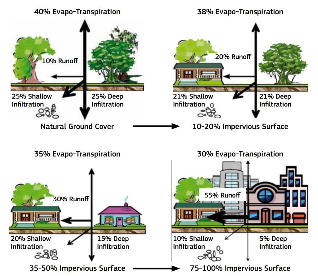
6 How much good soil we have? 13 to 18% of earth lands is covered with naturally fertile soils 1)Non soil, 2)too high, 3)too cold, 4)too hot, 5)too dry, 6)too poor, 7)salts, 8)low water, 9)conifers,10)too wet, 11)tropical 23 May

7 Map of global distribution of soil biodiversity 23 May
8 Map of potential threats to soil biodiversity 23 May
9 Erosion Erosion is ranked as the most important threat to the soil in Africa, Asia, Latin America and the Caribbean, North America, and the Near East and North Africa. Annual crop losses due to erosion have been estimated at 0.3% of crop yields. If erosion continues at this rate, a total reduction of over 10 percent could take place by the year Erosion on croplands and intensively grazed land is 100 to 1,000 times the natural background rate. The annual cost of fertilizer to replace nutrients lost to erosion is US$110-US$200 billion.

10 Soil Organic Carbon (SOC) loss Soils contain nearly three times as much carbon as is stored in all terrestrial plants The primary driver of loss in soil organic carbon is land use change. When land is converted from native forest to crops, soil carbon decreases by 42 percent. When pasture is converted to crops the reduction in soil carbon is even greater 59 percent. Loss in the global pool of soil organic carbon since 1850 is estimated at 66 billion tonnes, much of which remains in the atmosphere. Map of change in soil carbon due to land use change and land management from 1860 to 2010 from three vegetation models. Pink indicates loss of soil carbon, blue indicates carbon gain.

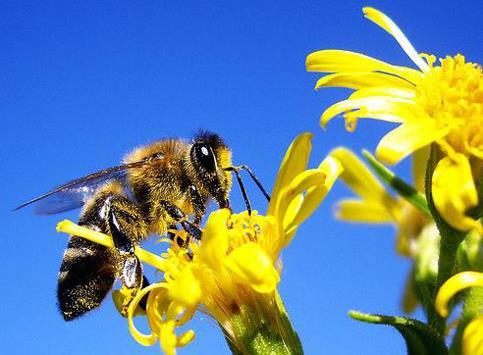
11 Nutrient imbalance The greatest obstacle to improving food production and soil function in many degraded landscapes is the lack of nutrients, especially nitrogen and phosphorus, and organic inputs. In Africa, all but three countries mine more nutrients from the soil every year than are returned through use of fertilizer, crop residues, manure, and other organic matter. In other areas, oversupply of nutrients contaminates soil and water resources and contributes to greenhouse gas emissions. In 2010, nitrogen oxide emissions from agricultural soils caused by the addition of synthetic fertilizers were the equivalent of 683 million tonnes of CO 2. Nutrient availability in soils


12 Soil salinization An estimated 760,000 km 2 of land worldwide are affected by humaninduced salinity an area larger than all the arable land in Brazil. Ill-designed, large-scale irrigation projects are the main cause of human-made salinization. Increasing soil salinity takes an estimated 3,000 to 15,000 km 2 of irrigated cropland out of production every year and decreases the production potential of much more land.
 is contaminated with heavy metals.")

13 Soil contamination Soil contamination damages food security, both because toxic levels of contaminants reduce crop yields and because crops that are produced can be unsafe to consume. Nearly a fifth of the farmland in China (19.4%) is contaminated with heavy metals. Over 130 million people worldwide routinely consume well-water with arsenic concentrations that exceed WHO recommendations More than 2.5 million potentially contaminated sites have been identified in Europe, of which 340,000 are expected to be contaminated. Global distribution of (a) atmospheric S deposition, (b) soil sensitivity to acidification and (c) atmospheric N deposition.

14 Soil acidification Around 30 percent of the topsoil and 75 percent of subsoil on the world s ice-free land is affected by acidity. The most acidic topsoils in the world are located in areas of South America that have experienced deforestation and intensive agriculture. The main causes of humaninduced acidification are acid deposition (commonly called acid rain) and massive application of ammonium-based fertilizers. Use of high-nitrogen fertilizers and high rates of product removal increase soil acidity in intensive agricultural areas.

15 Soil compaction Soil compaction has degraded up to 330,000 km 2 in Europe. Worldwide compaction has degraded an estimated 680,000 km 2 of soil, or around 4% of the total land area. Soil compaction can reduce crop yields by as much as 60 percent. Cattle trampling and insufficient cover of top soil by natural vegetation or crops account for compaction of 280,000 km 2 in Africa and Asia. The damage caused by soil compaction is long-lasting or even permanent. A one-time compaction event can lead to reduced crop yields up to 12 years later. Soil compaction risk derived from intensity of tractor use in crop land and from livestock density in grasslands.


16 Soil sealing Land take and soil sealing are regarded as the greatest threat to soil functions in Europe and Eurasia. Over 70% of the land take in the European Union between 1990 and 2000, and over half of the take between 2000 and 2006 consumed agricultural land. In 2000, urban areas covered 657,000 km 2, equivalent to almost 4% of the arable land on the planet. Between 1990 and 2006, the total extent of urban area worldwide increased by 58,000 km 2.
17

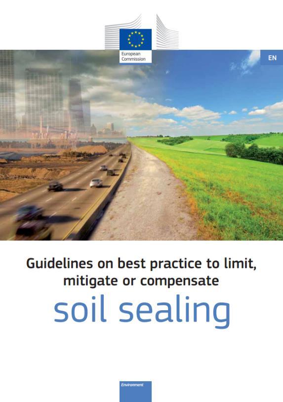
18 Ce lo dice l Europa L obiettivo dell azzeramento del consumo di suolo è stato definito a livello europeo già con la Strategia tematica per la protezione del suolo del 2006, che ha sottolineato la necessità di porre in essere buone pratiche per ridurre gli effetti negativi del consumo di suolo e, in particolare, della sua forma più evidente e irreversibile: l'impermeabilizzazione (soil sealing). Questo obiettivo generale è stato ulteriormente richiamato nel 2011, con la Tabella di marcia verso un Europa efficiente nell impiego delle risorse, nella quale si propone il traguardo di un incremento dell occupazione netta di terreno pari a zero da raggiungere, in Europa, entro il L obiettivo è stato rafforzato nel 2014 dal Parlamento Europeo con l'approvazione del Settimo Programma di Azione Ambientale. La Commissione ha ritenuto utile anche indicare le priorità di azione e le modalità per raggiungere tale obiettivo e, nel 2012, ha pubblicato le linee guida per limitare, mitigare e compensare l impermeabilizzazione del suolo. 1. Commissione Europea (2006) Strategia tematica per la protezione del suolo, COM(2006) 231 ( 2. Commissione Europea (2011) Tabella di marcia verso un Europa efficiente nell impiego delle risorse, COM(2011) 571 ( 3. Council and European Parliament (2013) Decision of the European Parliament and of the Council on a General Union Environment Action Programme to 2020 "Living Well, within the Limits of our Planet" ( 4. Commissione Europea (2012) Guidelines on best practice to limit, mitigate or compensate soil sealing SWD (2012) 101 (


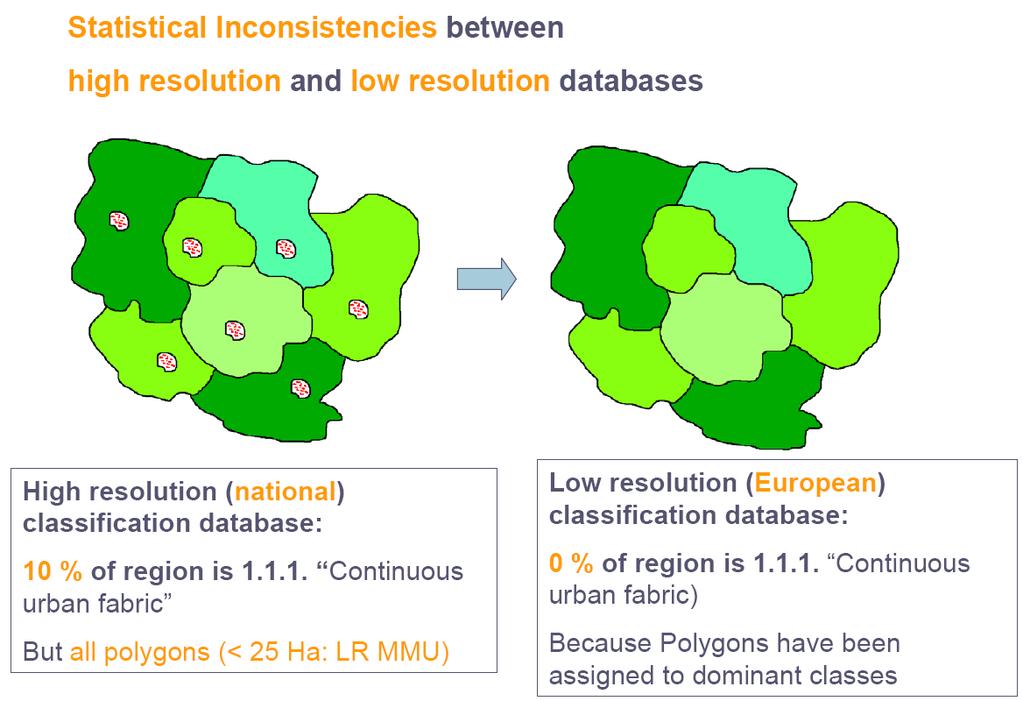
19 Consumo di suolo (una definizione) Variazione da una copertura non artificiale a una copertura artificiale del suolo 19
20 Per copertura del suolo (Land Cover) si intende la copertura biofisica della superficie terrestre, comprese le superfici artificiali, le zone agricole, i boschi e le foreste, le aree seminaturali, le zone umide, i corpi idrici, come definita dalla direttiva 2007/2/CE. L impermeabilizzazione del suolo, ovvero la copertura permanente di parte del terreno e del relativo suolo con materiali artificiali (quali asfalto o calcestruzzo) per la costruzione, ad esempio, di edifici e strade, costituisce la forma più evidente e più diffusa di copertura artificiale. Solo una parte dell area di insediamento è davvero impermeabilizzata, poiché giardini, parchi urbani e altri spazi verdi non devono essere considerati (Commissione Europea, 2013). Altre forme di copertura artificiale del suolo vanno dalla perdita totale della risorsa suolo attraverso l asportazione per escavazione (comprese le attività estrattive a cielo aperto), alla perdita parziale, più o meno rimediabile, della funzionalità della risorsa a causa di fenomeni quali la compattazione. L uso del suolo (Land Use) è, invece, un riflesso delle interazioni tra l uomo e la copertura del suolo e costituisce quindi una descrizione di come il suolo venga impiegato in attività antropiche. La direttiva 2007/2/CE lo definisce come una classificazione del territorio in base alla dimensione funzionale o alla destinazione socioeconomica presenti e programmate per il futuro (ad esempio: residenziale, industriale, commerciale, agricolo, silvicolo, ricreativo). Un cambio di uso del suolo (e ancora meno un cambio di destinazione d uso del suolo previsto da uno strumento urbanistico) potrebbe non avere alcun effetto sullo stato reale del suolo, che potrebbe mantenere intatte le sue funzioni e le sue capacità di fornire servizi ecosistemici.
21 LAND COVER LAND USE LAND TAKE SOIL CONSUMPTION SOIL SEALING
natural areas, wetlands, water bodies ELU: Existing land use (Current Land Use) PLU: Planned land use")
22 DIRETTIVA INSPIRE (2007/2/EC) LAND USE_LAND COVER LAND USE Territory characterized according to its current and future planned functional dimension or socio economic purpose (e.g. residential, industrial, commercial, agricultural, forestry, recreational). LAND COVER Physical and biological cover of the earth's surface including artificial (semi-)natural areas, wetlands, water bodies ELU: Existing land use (Current Land Use) PLU: Planned land use (Future Planned Land Use)

 (Commissione Europea, 2012) The aim is to raise")
23 What does no net land take mean? Sealing agricultural land and open spaces should be avoided as far as possible and the focus should be on building on land that has already been sealed (Commissione Europea, 2016) Land take includes the development of scattered settlements in rural areas and the conversion of land within an urban area (densification) (Commissione Europea, 2012) The aim is to raise awareness about the value of land as a resource for crucial ecosystem services (Commissione Europea, 2016)
24 aree non vegetate alberi, arbusti Il consumo di suolo tra il 2008 e il 2013 in Italia vegetazione erbacea, seminativi altre aree impermea bilizzate Edifici, costruzioni aree naturali aree urbane aree estrattive, discariche, cantieri serre permanenti altre aree pavimenta te infrastrutture aree agricole
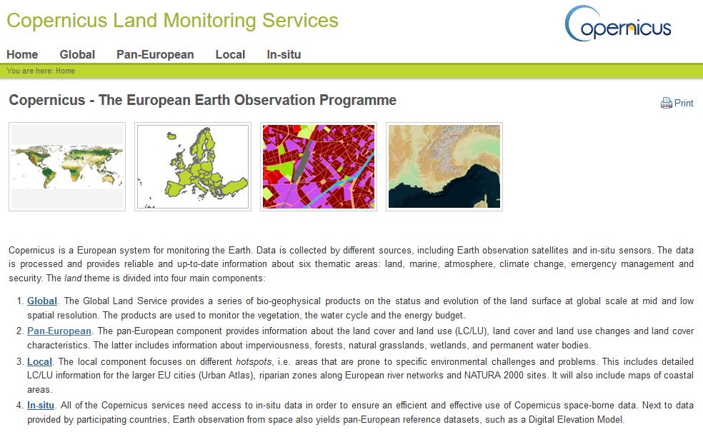
25 Monitoraggio del territorio in Europa Copernicus (Land Monitoring) Lucas (Land Use and Coverage Area frame Survey) 25
26 Commercial contracts e Il programma Copernicus è coordinato e gestito dalla Commissione Europea. Lo sviluppo delle infrastrutture di osservazione viene effettuata sotto l'egida dell'agenzia spaziale Europea (ESA) per la componente spaziale e dell'agenzia Europea dell Ambiente (EEA) e gli Stati membri per la componente in situ. Programme Programme Manager Presenza italiana: Copernicus Committe: MIUR, ASI, ISPRA Copernicus User Forum: ISPRA, ASI Committee User Forum In-situ Component* Services Space Component Land Monitoring Emergency Management Atmosphere Monitoring Maritime Environment Monitoring Climate Change Security DA with System architecture DA with Requirements of the Copernicus for space Space Component component Pan European & Local Components Global Systematic and hotspot component Mapping Early Warning System Border Surveillance Maritime Surveillance External Actions - Copernicus Board Procurement Board - Copernicus Board DA with EEA CSD with Joint Research Centre CSD with Joint Research Centre DA with DA with DA with DA with DA with (tbd) Data Dissemination Infrastructure Launch Services Sentinel 1,2,3,5P Space Segment Development & Construction Sentinel 1 Sentinel 2 Sentinel 3 LAND MARINE Sentinel 4 Launch Services Sentinel 4,5 Sentinel 5 Precursor (5P) Sentinel 5 Launch Services Sentinel 6 provided by the USA Sentinel 6 Data Dissemination Infrastructure (EUMETCast) Next generation of user requirements for the services and the space component Member State institutions Service Providers Service Providers Service Providers Service Providers Service Providers Service Providers Service Providers Service Providers Service Providers Ground Segment Development and Operations Ground Segment Development and Operations Services Service data High level applications requirements technical requirements Legend: Implementation mode still to be defind: Mode of Implementation (direct/indirect): Coordination by EEA Copernicus component Indirect Management DA - Delegation agreement Grants Service Providers Direct Management * CSD - Cross Sub-delegation ESA - European Space Agency EUMETSAT - European Organisation for the Exploitation of FRONTEX - The European Agency f or the Managment of Operational Meteorological Satellites Cooperation at the External Borders of the Member States of the European Union EEA - European Environment Agency ECMWF - The European Centre f or Medium-Range Weather Forecasts EUSC - European Union Satellite Center

27 Evolution of GMES/Copernicus Land Products and Services GMES FAST TRACK Services Core Mapping Services: Euroland GIO Land Components Copernicus Land Monitoring Services Land cover and land use mapping at European scale; More detailed land cover and land use mapping of urban and Natura2000 zones; Delivery of a pan- European digital elevation model. Continental component; Local component (information on specific areas of interest). Global component; Pan-European land cover, land cover change and land cover characteristics; Local component (information on specific areas of interest); In-situ data. Global component; Pan-European land cover, land cover change and land cover characteristics; Local component (information on specific areas of interest); In-situ data. Products: Degree of soil sealing, 2006 Products: Corine Land Cover 2006 Degree of soil sealing, 2009 HRLs on demonstration sites Urban Atlas on demonstration sites Products: Bio-geophysical products (NDVI, LAI, etc.) Urban Atlas for 305 Large Urban Zones Products: The Digital Elevation Model over Europe Sentinel 1 images In production: Corine Land Cover 2012 HRLs 2012 Sentinels images 27
28


29 CORINE Land Cover e Urban Atlas CORINE Land Cover: 38 Paesi Europei (risoluzione 25 ha) Urban Atlas: Larger Urban Zones (risoluzione 0,25 ha)
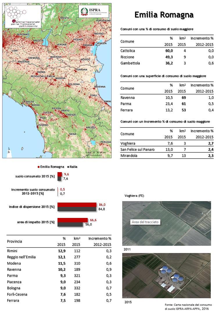
 Permanent grassland (2012) Wetlands (2012) Permanent Water bodies (2012)")
30 High Resolution Layers Degree of Imperviousness (2006, 2009, 2012) Tree Cover Density and Forest Type (2012) Permanent grassland (2012) Wetlands (2012) Permanent Water bodies (2012) 30


31 L. 132/2016 Il monitoraggio del territorio e del consumo di suolo


32 Copernicus EU map National map (ISPRA)
 7% (era il 2,7%")
33 Il consumo in Italia km 2 (2015) 7% (era il 2,7% negli anni 50) 33
34 Dove? km 2 nelle città metropolitane (2015) 700 km 2 a Roma 400 km 2 a Napoli Il 60% avviene in aree agricole Lungo le coste 21,9% entro i 300 m (quasi il 50% in Liguria) 19,3% entro 1 km 34


35 Netherlands Belgium Luxembourg Germany Italy Danmark Cyprus United Kingdom Portugal France Austria Czech Republic European Union Ireland Greece Spain Hungary Poland Slovenia Slovakia Lithuania Romania Bulgaria Estonia Latvia Finland Sweden , (Eurostat, 2015) 35


36 3% in aree a pericolosità da frana molto elevata o elevata 10,5% in aree a pericolosità idraulica (quasi il 30% in Liguria) 7,2% in aree a pericolosità sismica alta 7,2% nella fascia a distanza di 150 metri dai corsi d acqua 36

")
37 Il territorio urbanizzato (Milano) 23/05/
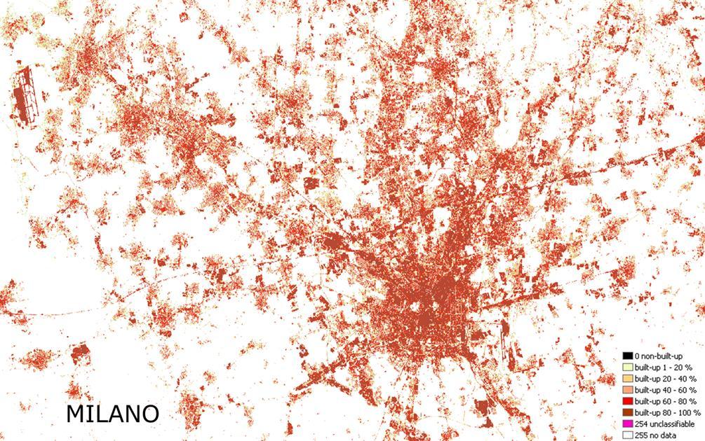
38 23/05/
39 m 2 /s La velocità del consumo 7% 12 6% 5% 4% 3% 250 km 2 (negli ultimi due anni) %

40 m 2 /s 2050: zero consumo di suolo Velocità del consumo di suolo Altri km 2 fino al 2050 Altri km 2 fino al 2050 Altri km 2 fino al
 Aree industriali, commerciali e dei servizi pubblici e privati Zone residenziali a tessuto discontinuo e rado In Italia, tra il 1990 e il 2012, quasi il 40% delle grandi trasformazioni urbane è")
41 100% 50% 0% Altre aree artificiali (verde urbano, aree sportive, cantieri, discariche, etc.) Aree industriali, commerciali e dei servizi pubblici e privati Zone residenziali a tessuto discontinuo e rado In Italia, tra il 1990 e il 2012, quasi il 40% delle grandi trasformazioni urbane è avvenuto attraverso la creazione di aree a bassa densità, mentre più di un terzo è avvenuto con la realizzazione di nuovi poli commerciali, industriali e terziari. Le aree compatte ad alta densità rappresentano meno dell 1% delle nuove aree urbane. 41


; aree in prevalenza naturali o")
:")


42 Bucarest Bratislava Praga Riga Amsterdam Lussemburgo Parigi Berlino Lisbona Atene Sofia Vienna Copenaghen Roma Bruxelles Dublino Stoccolma Milano Firenze Roma Legenda aree ad alta densità (rosso); aree a bassa densità (rosa); aree in prevalenza naturali o seminaturali (bianco). * * * Indice di dispersione (ESPON, 2011): Calcolato come rapporto tra la superficie complessiva delle aree a bassa densità e la superficie sommatoria delle aree edificate a bassa e ad alta densità ricadenti all interno dei limiti comunali Indice di dispersione Padova 0

43 Piemonte Valle D'Aosta Lombardia Trentino-A.Adige Veneto Friuli V.Giulia Liguria Emilia-Romagna Toscana Umbria Marche Lazio Abruzzo Molise Campania Puglia Basilicata Calabria Sicilia Sardegna Italia 100 m 60 m Impatto del consumo di suolo suolo consumato 60m 100m 200m 43
![Emilia Romagna Italia suolo consumato 2015 [%] 9.6 7.](/docs-images/68/59646201/images/44-3.jpg "6 incremento suolo consumato 2012-2015 [%] 0.5 0.")


44 Emilia Romagna Italia suolo consumato 2015 [%] incremento suolo consumato [%] Provincia % km 2 Incremento % Rimini 12, ,3 Reggio nell Emilia 12, ,2 Modena 11, ,6 Ravenna 10, ,9 Parma 9, ,3 Piacenza 9, ,3 Bologna 9, ,7 Forlì-Cesena 7, ,5 Ferrara 7, ,7 indice di dispersione 2015 [%] area di impatto 2015 [%]


45 45
46 U S E C A S E 1 : W H A T H A S B E E N D O N E Land Monitoring Input data: More than 200 Rapid Eye images at 5m resolution (from ESA DWH) Reference year 2012 Preprocessing: Ortho-rectification/ Calibration / Cloud masking Production workflow based on HRL Imperviousness 2012 Semi-automatic built-up detection Integration of HRL Imperviousness (20m) into the training process of the automatic classifier Customization of the nomenclature towards a better integration into ISPRA land take estimation process (to be combined with the existent stratified sampling monitoring network) e.g. railways network, landfills and mines are included Integration of OSM database, topographic DB
, Parking areas, Roads, Railways, Mines, Landfills Link: www.consumosuolo.")
47 U S E C A S E 1 I N I T A L Y : T H E R E S U L T S Land Monitoring The first national map of land take at Very High Resolution in Italy Reference year: 2012 Resolution: 5m Coverage: national Content: binary imperviousness map Features included: Built-up (residential, industrial, etc.), Parking areas, Roads, Railways, Mines, Landfills Link:
")
, Il consumo di suolo in Italia, Rapporti 218/2015,")
48 U S E C A S E 1 I N I T A L Y : S O M E E X A M P L E S Land Monitoring Example Urban area 1 (Background: aerial photo) CORINE LC HRL IMD 2012 Urban Atlas ISPRA VHR2012 Source: ISPRA (2015), Il consumo di suolo in Italia, Rapporti 218/2015, ISPRA, Roma

, Il consumo di suolo in Italia, Rapporti")
49 U S E C A S E 1 I N I T A L Y : S O M E E X A M P L E S Land Monitoring CORINE LC HRL IMD 2012 Example Urban area 2 (Background: aerial photo) Urban Atlas ISPRA VHR2012 Source: ISPRA (2015), Il consumo di suolo in Italia, Rapporti 218/2015, ISPRA, Roma
 National VHR 2012 Imperviousness (5m) Land take distribution per region, with estimation derived from three different")
50 U S E C A S E 1 I N I T A L Y : T H E R E S U L T S Land Monitoring VHR 2012 land take estimation is close to the values derived from the sampling network monitoring strategy ISPRA National sampling network for land take monitoring Copernicus HRL 2012 Imperviousness (20m) National VHR 2012 Imperviousness (5m) Land take distribution per region, with estimation derived from three different sources: ISPRA National sampling network, Copernicus HRL Imperviousness 2012 (20m) and National VHR 2012 Imperviousness (5m). Source: ISPRA (2015), Il consumo di suolo in Italia, Rapporti 218/2015, ISPRA, Roma

51 CORINE Land Cover High Resolution Layers
52 23/05/

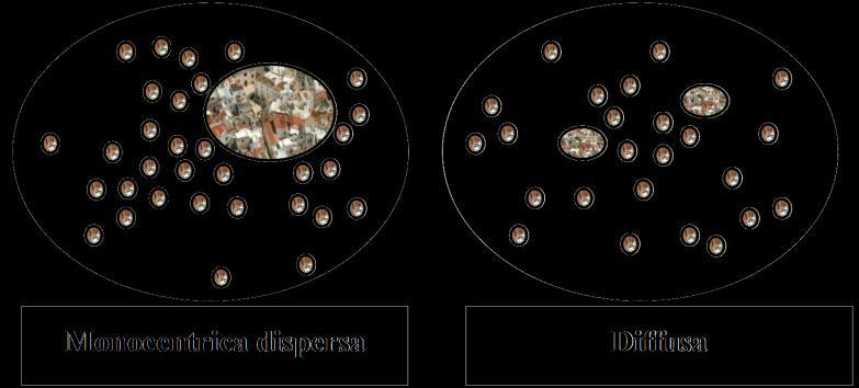
53 23/05/

54 U S E C A S E 1 : L A N D T A K E R E P O R T I N G Land Monitoring VHR 2012 layer has been used as input for the estimation of a series of landscape indicators (e.g. land take, urban sprawl, edge density) 2012 Land take (%) by city 2012 Land take (ha) by province Source: ISPRA (2015), Il consumo di suolo in Italia, Rapporti 218/2015, ISPRA, Roma

55 Classi Area totale in km² % sull area totale 20,63 8,52 2,69 5,27 0,92 0,31 25,29 5,52 22,23 0,08 5,16 2,27 1,11 23/05/
56 Classi Area totale in km² % sull area totale 14, ,21 1,91 0,36 0,38 32,27 1,61 12,53 0,46 8,08 6,18 1,05 23/05/
57 U S E C A S E 2 : V H R L A Y E R U P D A T I N G Land Monitoring Update 2015 Need to preserve high spatial and thematic accuracy obtained with the former 2012 VHR mapping exercise Need to ensure harmonized and regular approach in the land take estimation and monitoring over the national territory
58 U S E C A S E 2 : W H A T H A S B E E N D O N E Land Monitoring Input data: More than 100 Sentinel-2A images at 10m resolution ( ) Reference year 2015 Preprocessing: calibration, cloud masking, working units organization Production workflow based on change detection: Image change detection Resampling of VHR 2012 layer (5m) to 10m VHR 2012 layer as reference for training phase and correction of false changes Same nomenclature adopted for VHR 2012 layer VHR 2012 map updating and improving (commission/omission correction)

59 U S E C A S E 2 I N I T A L Y : T H E R E S U L T S Land Monitoring VHR 2015 Source: ISPRA (2016), (Detail on Sicily region) Consumo di suolo, dinamiche territoriali e servizi ecosistemici, Rapporti 248/2016, ISPRA, Roma Reference year: 2015 Resolution: 10m Coverage: Italy Content: Binary 2015 VHR map Change layer Binary 2012 corrected VHR map Features included: Built-up (residential, industrial, etc.), Parking areas, Roads, Railways, Mines, Landfills, permanent greenhouses Link:
60 U S E C A S E 2 I N I T A L Y : S O M E E X A M P L E S Land Monitoring map VHR 2012 (based on RapidEye ) VHR 2012_V1 (original) Background image: RapidEye image natural color (12 April 2011) Example area around Naples (South Italy)
 Background image: RapidEye image natural color (12 April 2011) Example area around Naples (South")
61 U S E C A S E 2 I N I T A L Y : S O M E E X A M P L E S Land Monitoring map VHR 2012 (based on RapidEye ) VHR 2012_V1 (original) Omission errors (discovered as false changes, during the imperviousness map updating process) Background image: RapidEye image natural color (12 April 2011) Example area around Naples (South Italy)
62 U S E C A S E 2 I N I T A L Y : S O M E E X A M P L E S Land Monitoring map VHR 2012 (based on RapidEye ) VHR 2012_V2 (corrected) Background image: RapidEye image natural color (12 April 2011) Example area around Naples (South Italy)
63 U S E C A S E 2 I N I T A L Y : S O M E E X A M P L E S Land Monitoring changes VHR VHR 2012_V2 (corrected) New 2015 map (real changes detected during the map updating process) Background image: Sentinel-2A natural color (22 June 2015) Example area around Naples (South Italy)
 VHR 2015 Background image: Sentinel-2A natural color (22 June 2015) Example area around Naples (South")
64 U S E C A S E 2 I N I T A L Y : S O M E E X A M P L E S Land Monitoring map VHR 2015 (based on Sentinel-2A ) VHR 2015 Background image: Sentinel-2A natural color (22 June 2015) Example area around Naples (South Italy)
65 Copernicus Built-up map m spatial resolution Sicily map Coastal buffer (300 m) Resampled 10 m Impervious areas Cloud areas
66 Copernicus Built-up map m spatial resolution Sicily map Coastal buffer (300 m) Resampled 10 m Impervious areas Cloud areas
 Built-up map 2015 Impervious areas Cloud")
67 Copernicus Built-up map m spatial resolution Sicily map Coastal buffer (300 m) Built-up map 2015 Impervious areas Cloud areas
68 Copernicus Built-up map m spatial resolution Sicily map Coastal buffer (300 m) Built-up map 2015 Impervious areas Cloud areas
69 Copernicus Built-up map m spatial resolution Sicily map Coastal buffer (300 m) Built-up map 2012 Change map Impervious areas Cloud areas
70 Copernicus Built-up map m spatial resolution Sicily map Coastal buffer (300 m) Built-up map 2012 Change map Impervious areas Cloud areas

71 Copernicus Change map m spatial resolution Sicily map Built-up map 2012 Built-up map 2015 Sentinel-2 image New impervious areas Unchanged impervious areas

72 Copernicus Sentinel 2-10 m spatial resolution Sicily map Built-up map 2012 Built-up map 2015 Sentinel 2 + maps Basemap + maps Change image Quit

73 Copernicus Sentinel 2-10 m spatial resolution Sicily map Built-up map 2012 Built-up map 2015 Sentinel 2 Basemap + maps Change image 2012 impervious areas 2015 impervious areas Quit
74 Copernicus Sicily map Built-up map 2012 Built-up map 2015 Sentinel 2 Sentinel 2 + maps Change image 2012 impervious areas 2015 impervious areas Quit
75 U S E C A S E 2 : L A N D T A K E R E P O R T I N G Land Monitoring The national VHR layer is a valuable basis for the direct computation of landscape INDICATORS, fundamental to the process of evaluation and environmental monitoring of urban and regional plans. A set of landscape indicators has been identified as feasible to be calculated using the VHR map as main input (together with auxiliary data such as administration boundaries, natural areas, etc.)
76 U S E C A S E 2 : E X A M P L E S O F I N D I C A T O R S Land Monitoring List of some indicators derived from VHR imperviousness layer Indicator Description Expression Land take Urban dispersion Edge Density (ED) Ecological impact Ratio between the imperviousness surface and the territory surface under analysis Ratio between the sum of sparse/discontinuos imperviousness area and the total imperviousness surface Ratio between the perimeter of the imperviousness polygons and the total surface under analysis Ration between the surface impacted by the occurrence of imperviousness and the total area under analysis. CSU = (Su / Str) x 100 Su: the imperviousness surface Str: surface under analysis Dsp = [(Sud + Sur) / Su] x 100 Sud: discontinuos imperviousness area Sur: sparse imperviousness area Su: total imperviousness surface ED = (SP / Str) x 10,000 SP: Sum of the perimeter of the imperviousness polygons Str: Total surface under analysis EI = (bufferarea / Str) x 100 bufferarea: measure of the buffered impervousness area (100m) Str: surface under analysis


77 Comune di Latina Comune di Torino 4 abitanti per ettaro 288 metri quadrati di suolo consumato pro capite 67 abitanti per ettaro 86 metri quadrati di suolo consumato pro capite

78 Urban Sprawl Assessment Valori di LCPI (Largest Class Patch Index) per comune (2015). È un indicatore della compattezza della città. Il valore è più elevato per aree urbane monocentriche con un centro urbano di dimensioni elevate e/o compatte. Valori inferiori si riscontrano in aree con un maggiore grado di diffusione urbana. Valori di RMPS (Residual Mean Patch Size) per comune (2015). È un indicatore della diffusione del tessuto urbano periferico, essendo calcolato come il valore medio della dimensione delle aree urbanizzate escludendo il poligono urbano più esteso. Per una corretta lettura dei dati è utile confrontare i valori con una misura di densità per valutare la consistenza sul territorio di aree più o meno disperse Indicatore LCPI (Largest Class Patch Index) RMPS (Residual Mean Patch Size) ED (Edge Density) Valori di ED (Edge Density) per comune (2015). Tale indicatore aumenta con la maggiore frammentazione dei margini urbani e con la dispersione insediativa. Passando da aree urbane con forma compatta a poligoni con confini più frastagliati l ED assume valori sempre maggiori, mentre invece per confini regolari l ED assume valori più bassi. Descrizione e significato Ampiezza percentuale del poligono di area costruita di dimensioni maggiori. È un indicatore di compattezza. Ampiezza media dei poligoni residui, escluso quello maggiore. Fornisce la dimensione della diffusione delle città attorno al nucleo centrale. Rapporto tra la somma totale dei perimetri dei poligoni delle aree costruite e 78 la loro superficie. Descrive la frammentazione del paesaggio in termini di densità dei margini del costruito.
79 Soil Consumption 79 Indicators of the Scenario [5] Use Case 2. Analysis of the Degree of Imperviousness for the calculation of landscape metrics at the municipal level. ED [m/ha]. It equals the sum of the lengths (m) of all edge segments involving the corresponding patch type, divided by the total landscape area (sqm), multiplied by (to convert to hectares).in other words it is the ratio between the total sum of the perimeters of the areas of the polygons constructed and municipal surface investigated. The indicator facilitates comparisons among landscapes of varying size and lends itself to be an effective measure of the shape and complexity of the different urban areas. In particular, the ED assumes increasing values, with the same surface area, in passing from urban areas with compact form in situations with limits more jagged. This indicator is expressed in meters per hectare and its range is ED>=0, without limit.
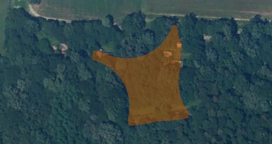
80 Soil Consumption 80 ED: 93,75 TE: 1320 ED: 206,84 TE: 2780 An example of ED (source: Deliverable B.14)
81 Soil Consumption 81 Indicators of the Scenario [6] Use Case 2. Analysis of the Degree of Imperviousness for the calculation of landscape metrics at the municipal level. MPA [ha]. It is based on the number of patches and provides the average size of the patch related to the class of urbanized surface. It is an indirect measure of habitat fragmentation, in fact progressive reduction in the size of habitat fragments is a key component of habitat fragmentation (MCGARIGAL). Thus, it can definitely be related to an increase in the number of patches. Although the MPS derives from the number of patches (NP), it does not refer to any direct information on the number of patches. MPS = 10 ha may refer to one or 100 patch. This indicator is expressed in hectares and its range is MPS>=0.
82 Soil Consumption 82 Indicators of the Scenario [4] Use Case 2. Analysis of the Degree of Imperviousness for the calculation of landscape metrics at the municipal level. RMPS Residual Mean Patch Size [ha]. It represents the average size of the polygons excluding the largest polygon and refers to the residual obtained by subtracting to the total built area, the area of the polygon greater. It is expressed in hectares. An example of RMPS (source: Deliverable B.14) RMPS: 1200 RMPS: 514


83
84 Land take is going to affect irreversibly on: Availability of natural resources and related ecosystem functions; Hydrogeological stability; Landscape structure; General life quality.


85 Uso del suolo --> Copertura del suolo --> Servizi ecosistemici 85
86 Servizi ecosistemici «Le condizioni e i processi attraversi i quali gli ecosistemi naturali e le specie che li compongono sostengono e permettono la vita umana» (Daily, 1997) «Benefici multipli forniti dagli ecosistemi al genere umano» (MEA, 2005) «Le condizioni e i processi degli ecosistemi che generano o aiutano a generare benefici per l umanità» (Guerry et al., 2015) Benefici per la popolazione Capitale naturale The value of the world s ecosystem services and natural capital. (Costanza et al., 1997) The economics of ecosystem and biodiversity (TEEB, 2010)


87


88 88


89 89
90 90


91 Morabito et al., 2016 Aumento di 20 ettari per km 2 di suolo consumato -> aumento di 0,6 C della temperatura superficiale 91
92 Quanto ci costa? milioni di euro Costi annuali aggiuntivi che si dovranno affrontare a livello nazionale a causa del consumo di suolo avvenuto tra il 2012 e il 2015 Regolazione del microclima 8,765,754 Impollinazione 2,750,232 Protezione dall erosione 120,569,544 Produzione legnosa 17,546,800 Infiltrazione dell acqua 99,350,810 Rimozione di particolato e ozono 1,925,019 Stoccaggio e sequestro del carbonio 144,803,812 Produzione agricola 424,293,454 Qualità degli habitat 5,274,924 92

93 93
94 Michele Munafò 94
Land Monitoring. Continental EEA pan-european products : Corine Land Cover Upgrade
 0 Land Monitoring Continental EEA pan-european products : Corine Land Cover Upgrade 5 High Resolution Layer: imperviousness, forest areas, agricultural areas/grasslands, wetlands, small water bodies Evoluzione
Le attività del Sistema Nazionale per la Protezione dell Ambiente per il monitoraggio del consumo di suolo
 Le attività del Sistema Nazionale per la Protezione dell Ambiente per il monitoraggio del consumo di suolo 1 Ines Marinosci e Michele Munafò (ISPRA), Vito Laghezza (ARPA Puglia) Legge 28 giugno 2016 n.132:
Lo scenario consumo di suolo e il sito pilota del Tigullio
 Lo scenario consumo di suolo e il sito pilota del Tigullio Ines Marinosci ISPRA Via Vitaliano Brancati 48, 00144 Roma ines.marinosci@isprambiente.it Scenario. Lo scenario consumo di suolo fa riferimento
Il consumo di suolo in Italia
 Il consumo di suolo in Italia Michele Munafò - ISPRA michele.munafo@isprambiente.it Milano, novembre 2014 Roma, febbraio 2014 Isola di calore (foto) Isola di calore Il consumo di suolo negli ultimi
Figura 1 - Territorio con copertura artificiale -Anno 2009 (incidenza percentuale sulla superficie totale)
") Allegato statistico Audizione del Presidente dell Istituto nazionale di statistica, Enrico Giovannini Commissione XIII Territorio, Ambiente e Beni ambientali del Senato della Repubblica Roma, 18 gennaio
Allegato statistico Audizione del Presidente dell Istituto nazionale di statistica, Enrico Giovannini Commissione XIII Territorio, Ambiente e Beni ambientali del Senato della Repubblica Roma, 18 gennaio
Tabella 1 - Spesa per i servizi per il lavoro pubblici in Europa ( LMP Category 1 ) Milioni di euro. Anni
 Milioni di euro. Anni") Tabella 1 - Spesa per i servizi per il lavoro pubblici in Europa ( LMP Category 1 ) Milioni di euro. Anni 2005-2011 2005 2006 2007 2008 2009 2010 2011 European Union (27 countries) 24.258,853 23.236,823
Tabella 1 - Spesa per i servizi per il lavoro pubblici in Europa ( LMP Category 1 ) Milioni di euro. Anni 2005-2011 2005 2006 2007 2008 2009 2010 2011 European Union (27 countries) 24.258,853 23.236,823
Padova, 20 June By Adrian Van Den Hoven International Relations Director (BUSINESSEUROPE)
") Padova, 20 June 2011 By International Relations Director (BUSINESSEUROPE) www.businesseurope.eu 20 June 2011 BUSINESSEUROPE: 40 members in 34 countries DI NEW -... Austria Belgium Bulgaria Croatia Cyprus
Padova, 20 June 2011 By International Relations Director (BUSINESSEUROPE) www.businesseurope.eu 20 June 2011 BUSINESSEUROPE: 40 members in 34 countries DI NEW -... Austria Belgium Bulgaria Croatia Cyprus
Una ricerca in progress sul consumo del suolo
 Roma, 1 giugno 2013 Una ricerca in progress sul consumo del suolo Bernardino Romano Università degli Studi dell Aquila Montelucodi Roio 67100 L Aquila (Italy)-Tel. ++390862434113 bernardino.romano@univaq.it
Verifica e Miglioramento degli High Resolution Layers Copernicus in Italia
 Verifica e Miglioramento degli High Resolution Layers Copernicus in Italia M. Munafò (*), B. Alesse (***), L. Congedo (**), F. Ferraro (***), P. De Fioravante (***), S. Marzeddu (***), L. Sallustio (**),
Regione Detenuti presenti Agenti in forza. Totale 59.419 39.156
 Rapporto tra detenuti presenti e agenti in forza: situazione al 13 febbraio 2009 Regione Detenuti presenti Agenti in forza Abruzzo 1.741 1.306 Basilicata 563 490 Calabria 2.367 1.682 Campania 7.332 5.010
Monitorare il consumo di suolo
 Monitorare il consumo di suolo Elisabetta Peccol elisabetta.peccol@uniud.it Dip. di Scienze Agrarie e Ambientali Università degli Studi di Udine Consumo di suolo o Consumo di territorio? Normative europee
Quadro complessivo Componente In-situ e Componente Servizi
 Programma europeo per l osservazione della Terra Workshop Nazionale Quadro complessivo Componente In-situ e Componente Servizi Prof. Bernardo De Bernardinis Presidente ISPRA Co-Delegato Nazionale Comitato
Caratterizzazione morfologica del consumo di suolo: analisi delle tipologie insediative Riitano Nicola*, Munafò Michele**, Congedo Luca**
 Caratterizzazione morfologica del consumo di suolo: analisi delle tipologie insediative Riitano Nicola*, Munafò Michele**, Congedo Luca** *Sapienza Università di Roma Dottorato Paesaggio e Ambiente **ISPRA
Povertà dei minori in Italia in prospettiva comparata. Gli effetti della crisi e delle politiche
 Povertà dei minori in Italia in prospettiva comparata. Gli effetti della crisi e delle politiche Chiara Saraceno Honorary fellow Collegio Carlo Alberto Caratteristiche della povertà in Italia Fenomeno
Un analisi della partecipazione italiana al primo ciclo di bandi SC6
 Un analisi della partecipazione italiana al primo ciclo di bandi SC6 Monique Longo APRE Punto di Contatto nazionale Horizon Societal Challenge 6 "Europe in a changing world Inclusive, Innovative and Reflective
A Solar Energy Storage Pilot Power Plant
 UNIONE DELLA A Solar Energy Storage Pilot Power Plant DELLA Project Main Goal Implement an open pilot plant devoted to make Concentrated Solar Energy both a programmable energy source and a distribution
Partecipazione Italiana alle Call ENV 2012
 Steering Committee Ricerca Ambientale Sede ENEA, Roma 20 giugno 2012 Partecipazione Italiana alle Call ENV 2012 Pierpaolo Campostrini CORILA, Director Consortium for Managing Research Activities in the
Epidemiologia della tubercolosi
 Sorveglianza della tubercolosi nelle strutture sanitarie e socio-assistenziali Parma, 19 maggio 26 Epidemiologia della tubercolosi Bianca Maria Borrini Dipartimento Sanità Pubblica AUSL di Parma La tubercolosi
OCSE PISA 2009 Programme for International Student Assessment
 7 dicembre 2010 INVALSI OCSE PISA 2009 Programme for International Student Assessment Risultati nazionali La rilevazione OCSE PISA 2009 Quarta edizione del programma PISA (rilevazioni triennali). Obiettivo
Evoluzione delle strutture commerciali organizzate sul territorio nazionale
 Evoluzione delle strutture commerciali organizzate sul territorio nazionale Le attuali caratteristiche del mercato Retail in Italia Debole propensione all acquisto da parte del cliente Limitato incremento
Ammissibilità di co.co.co. e AdR in H2020. Laura Fulci Dirigente Area Ricerca Politecnico di Torino
 Ammissibilità di co.co.co. e AdR in H2020 Laura Fulci Dirigente Area Ricerca Politecnico di Torino Conclusione della vicenda Ott. 2015 Dic. 2015 Feb. 2016 Mar. 2016 Giu. 2016 Set. 2016 Apr. 2017 Pubblicata
Dexia Crediop SpA. Italian Subsovereign Debt and Debt Management Perspectives. FABIO VITTORINI Responsabile delle Politiche Commerciali
 Dexia Crediop SpA Italian Subsovereign Debt and Debt Management Perspectives FABIO VITTORINI Responsabile delle Politiche Commerciali 11 91 316 municipalities in the EU in 2008 80% of municipalities in
CENTRO DI RICERCA SUI CONSUMI DI SUOLO (INU, LEGAMBIENTE, POLITECNICO DI MILANO)
") Urban Center, Scandicci 26 marzo 2015 Repertori informatici per l analisi ed il governo del Land Use Change alle diverse scale Quanto suolo consumiamo? (un problema di metodo) In Italia, l unico documento
Urban Center, Scandicci 26 marzo 2015 Repertori informatici per l analisi ed il governo del Land Use Change alle diverse scale Quanto suolo consumiamo? (un problema di metodo) In Italia, l unico documento
INTERNET & MARKETING INNOVATIVE COMMUNICATION.
 INTERNET & MARKETING INNOVATIVE COMMUNICATION www.sunet.it Passion Our passion to what we do every day allows us to have a special creativity and constantly improve the process of realization and execution.
Giovanni Franco Gianfranco Lazzarin H-Farm Roncade
 ENERGIAMEDIA Settore idrico: Criticità, opportunità e governance Giovanni Franco Gianfranco Lazzarin H-Farm Roncade 31.5.2017 Indice 1. Alcune considerazioni di inquadramento Università Bocconi - Utility
3D territory modeling supporting Containment and Abatement of Noise Plans
 3D territory modeling supporting Containment and Abatement of Noise Plans La modellazione del territorio 3D a supporto dei piani di Contenimento e Abbattimento del Rumore European and National laws Legge
Pratiche e Competenze per la Promozione della Salute: la visione europea
 Pratiche e Competenze per la Promozione della Salute: la visione europea Giancarlo Pocetta Centro Sperimentale per l Educazione Sanitaria Universitàdi Perugia Health education Health education comprises
H2020 ICT Summary Results.
 H00 ICT - 06 Summary Results www.apre.it APRE 03 LEIT-ICT 06 Call Call identifier: ICT 06 - Deadline: th April 06 Indicative budget: 460,7 M LEIT-ICT 06 Call Budget distribution by main ICT Area % % A
A free and stand-alone tool integrating geospatial workflows to evaluate sediment connectivity in alpine catchments
 A free and stand-alone tool integrating geospatial workflows to evaluate sediment connectivity in alpine catchments S. Crema, L. Schenato, B. Goldin, L. Marchi, M. Cavalli CNR-IRPI Outline The evaluation
Appendice A. Conduttori elettrici, sezioni e diametri Appendix A. Wires, Sizes and AWG diameters
 Appendice A. Conduttori elettrici, sezioni e diametri Appendix A. Wires, Sizes and AWG diameters A.1 Misura dei conduttori elettrici, sezioni e diametri AWG and kcmil wires sizes measurement L America
Definizione di terminalità
 Definizione di terminalità...pz: Dottoressa io obbietto. io non terminerò io morirò! CS: Mr T non è Lei bensi la sua malattia che terminerà Da allora non ho piu parlato di pazienti terminali ma di pazienti
Analisi spazio-temporale di social media per l identicazione di eventi
 Analisi spazio-temporale di social media per l identicazione di eventi P. Arcaini 1, G. Bordogna 2,3, E. Mangioni 3, S. Sterlacchini 3 1 Department of Engineering, University of Bergamo 2 National Research
MAPPARE IL CONSUMO DI SUOLO TRAMITE TELERILEVAMENTO
 X Convegno GIT Geosciences and Information Technologies Group San Leo, 17-19 giugno 2015 MAPPARE IL CONSUMO DI SUOLO TRAMITE TELERILEVAMENTO Rossella Casciere, Gabriele Bitelli DIPARTIMENTO INGEGNERIA
Development and Human Resources the Emilia Romagna Approach
 San Bernardo do Campo, March2, 2016 Development and Human Resources the Emilia Romagna Approach Prof.Patrizio Bianchi Regione Emilia Romagna and University of Ferrara - 1391 Emilia-Romagna Region Overall
Le iniziative in corso del bacino padano ed i finanziamenti statali e regionali per interventi di miglioramento della qualità dell'aria"
 Le iniziative in corso del bacino padano ed i finanziamenti statali e regionali per interventi di miglioramento della qualità dell'aria" Reggio Reggio Emilia Emilia 20/11/2008 LA NUOVA DIRETTIVA COMUNITARIA
 Politecnico de Milano Dipartamento di Architettura e Pianificazione Laboratorio di Qualità Urbana e Sicurezza Laboratorio Qualità urbana e sicurezza Prof. CLARA CARDIA URBAN SAFETY AND QUALITY LABORATORY
April Second auction for the regasification and storage bundled service for the storage gas year 2017/2018
 April 2017 Second auction for the regasification and storage bundled service for the storage gas year 2017/2018 28-04-2017 Comunicato Stampa OLT OFFSHORE LNG TOSCANA TERMINALE OLT: AL VIA LA SECONDA ASTA
ANALISI DEI PERICOLI Hazard Analysis
 7.4 ANALISI DEI PERICOLI Hazard Analysis Identificazione Valutazione Misure di Controllo Identification Assessment Control Measures Taccani 1 7.4.2 Identificare i pericoli e i livelli accettabili Identify
ILLY AND SUSTAINABILITY
 ILLY AND SUSTAINABILITY DARIA ILLY BUSINESS DEVELOPMENT - PORTIONED SYSTEMS DIRECTOR NOVEMBER 14 THE COMPANY Trieste 1 9 3 3, I t a l y R u n b y t h e I l l y f a m i l y D i s t r i b u t e d i n m o
Fitofarmaci Un indicatore di pressione elaborando proprietà ambientali e dati di utilizzo dei prodotti fitosanitari. Alessandro Franchi ARPA Toscana
 Fitofarmaci Un indicatore di pressione elaborando proprietà ambientali e dati di utilizzo dei prodotti fitosanitari Alessandro Franchi ARPA Toscana L'uso di pesticidi in agricoltura produce un impatto
Padova Smart City. Internet of Things. Alberto Corò
 Padova Smart City Internet of Things Alberto Corò Padova 16 ottobre 2013 Smart City Le smart cities ("città intelligenti") possono essere classificate lungo 6 aree di interesse: Economia Mobilità Ambiente
LOCALIZZAZIONE LOCATION
 LOCALIZZAZIONE LOCATION Il Centro Commerciale si trova a Urbino in Viale Antonio Gramsci, presso la Porta di Santa Lucia: una posizione particolarmente favorevole perché rappresenta un punto di accesso
I CORSI DI LAUREA MAGISTRALE NELL AREA DEI BENI CULTURALI E DEL TURISMO
 I CORSI DI LAUREA MAGISTRALE NELL AREA DEI BENI CULTURALI E DEL TURISMO Management dei beni culturali (LM-89) itourdem International Tourism and Destination Management (LM-49) Giornata della matricola
Village for sale in Florence. www.villecasalirealestate.com/en/property/402/village-for-sale-in-florence
 Ref: 0403 Village for sale in Florence www.villecasalirealestate.com/en/property/402/village-for-sale-in-florence Price upon request Area Municipality Province Region Nation Lastra a Signa Florence Tuscany
IL FUTURO DELLA RETE LA DOMANDA DI INTERNET LE RETI E LE INIZIATIVE PUBBLICHE PER LA BANDA LARGA KEY FIGURES. Roma, 20 aprile 2010
 OSSERVATORIO SULLA DIFFUSIONE DELLE RETI TELEMATICHE E DEI SERVIZI ON LINE IL FUTURO DELLA RETE LA DOMANDA DI INTERNET LE RETI E LE INIZIATIVE PUBBLICHE PER LA BANDA LARGA KEY FIGURES Roma, 20 aprile 2010
Elena Cervasio LRQA Italy. La certificazione dell impronta di carbonio secondo la ISO 14067:2013 - il chiusino KIO
 Elena Cervasio LRQA Italy La certificazione dell impronta di carbonio secondo la ISO 14067:2013 - il chiusino KIO Motivazioni e Milestone INNOVAZIONE E SOSTENIBILITÀ AMBIENTALE 2 Scenario INNOVAZIONE E
NATURA STANDARD DATA FORM
 NATURA 2000 - STANDARD DATA FORM For Special Protection Areas (SPA), Proposed Sites for Community Importance (psci), Sites of Community Importance (SCI) and for Special Areas of Conservation (SAC) SITE
Price upon request. Ref: Sale Antico Borgo Noble
 Ref: 0518 Sale Antico Borgo Noble 1700 www.villecasalirealestate.com/en/property/518/sale-antico-borgo-noble-1700 Price upon request Area Municipality Province Region Nation Costa Ionica Rossano Calabro
An INSPIREd application to design landslide risk environmental impacts
 An INSPIREd application to design landslide risk environmental impacts Carlo Cipolloni, Daniele Spizzichino, Gabriele Leoni ISPRA Geological Survey of Italy carlo.cipolloni@isprambiente.it Landslide Pilot
Resources and Tools for Bibliographic Research. Search & Find Using Library Catalogues
 Resources and Tools for Bibliographic Research Search & Find Using Library Catalogues November 28, 2011 Donata Pieri Index Definition University of Padova Library System Catalogue CaPerE E-journals Catalogue
La direttiva sull uso delle energie rinnovabili Piani d azione nazionali sull uso delle energie rinnovabili.
 1 La direttiva 20-20-20 sull uso delle energie rinnovabili Piani d azione nazionali sull uso delle energie rinnovabili. F. Monforti JRC Istituto per l Energia Fabio.monforti-ferrario@ec.europa.eu La direttiva
Tavola 1A - FUNZIONI PREVALENTI
 Anno Accademico 2016-17 Laboratorio di Progettazione Urbanistica 3 Roma Città Territorio Tavola 1A - FUNZIONI PREVALENTI 12-14.10.2016 Finalità dell esercitazione distinguere all interno del territorio
Online Resource 12: Dataset
 Online Resource 12: Dataset Article Title: Temperature observations in Bologna, Italy, from 1715 to 1815; a comparison with other contemporary series and an overview of three centuries of changing climate
Indicatore CI- 45: GHG emissions from agriculture ISPRA - Istituto Superiore per la Protezione e Ricerca Ambientale
 Luogo e data Eleonora Di Cristofaro Indicatore CI- 45: GHG emissions from agriculture ISPRA - Istituto Superiore per la Protezione e Ricerca Ambientale Emissioni totali nette di gas serra del settore agricoltura
ERASMUS PLUS. KA1 School education staff mobility/ Adult education staff mobility
 ERASMUS PLUS Disposizioni nazionali allegate alla Guida al Programma 2016 Settore Istruzione Scolastica, Educazione degli Adulti e Istruzione Superiore KA1 School education staff mobility/ Adult education
ERASMUS PLUS. KA1 School education staff mobility/ Adult education staff mobility
 ERASMUS PLUS Disposizioni nazionali allegate alla Guida al Programma 2014 Settore Istruzione Scolastica, Educazione degli Adulti e Istruzione Superiore KA1 School education staff mobility/ Adult education
Convegno Qualità Microbiologica dei Cosmetici: Aspetti Tecnici e Normativi Milano, 15 maggio Lucia Bonadonna Istituto Superiore di Sanità
 Convegno Qualità Microbiologica dei Cosmetici: Aspetti Tecnici e Normativi Milano, 15 maggio 2015 Lucia Bonadonna Istituto Superiore di Sanità REGOLAMENTO (CE) n. 1223/2009 DEL PARLAMENTO EUROPEO E DEL
R.M.Dorizzi, Strumenti per interpretare gli esami di laboratorio? Forlì, 9 ottobre 2012
 1 Half of what you are taught as medical students will in 10 years have been shown to be wrong. And the trouble is, none of your teachers know which half. Sydney Burwell, Dean Harvard Medical School 1935-1949
LA STORIA STORY THE COMPANY ITI IMPRESA GENERALE SPA
 LA STORIA ITI IMPRESA GENERALE SPA nasce nel 1981 col nome di ITI IMPIANTI occupandosi prevalentemente della progettazione e realizzazione di grandi impianti tecnologici (termotecnici ed elettrici) in
Testo. Possibili sviluppi in un ottica di filiera. Nicola Cantore Overseas Development Institute
 Possibili sviluppi in un ottica di filiera Nicola Cantore Overseas Development Institute 1 Vantaggi nel calcolo del Carbon Footprint (FAO 2011) - Mezzo a disposizione dei decisori politici per sensibilizzare
Il Patto dei Sindaci. Monitorare I risultati. Elodie Bossio. Covenant of Mayors Office FEDARENE 31 March 2015
 Il Patto dei Sindaci Monitorare I risultati Elodie Bossio Covenant of Mayors Office FEDARENE 31 March 2015 Un successo crescente... 6260 firmatari... 196 millioni cittadini... 177 regioni, province,...
WHERE World HEritage monitoring by Remote sensing
 WHERE World HEritage monitoring by Remote sensing L Osservazione della Terra a salvaguardia dei Beni Culturali MONITORAGGIO DEGLI ASPETTI METEO-CLIMATICI DI UN SITO DOTT. MARCO FOLEGANI (MEEO) Monitoraggio
Copyright 2012 Binary System srl 29122 Piacenza ITALIA Via Coppalati, 6 P.IVA 01614510335 - info@binarysystem.eu http://www.binarysystem.
 CRWM CRWM (Web Content Relationship Management) has the main features for managing customer relationships from the first contact to after sales. The main functions of the application include: managing
We take care of your buildings
 We take care of your buildings Che cos è il Building Management Il Building Management è una disciplina di derivazione anglosassone, che individua un edificio come un entità che necessita di un insieme
DALLA CONVENIENZA ECONOMICA ALLA CONVENIENZA ECOLOGICA
 ECODESIGN & INNOVAZIONE: DALLA CONVENIENZA ECONOMICA ALLA CONVENIENZA ECOLOGICA Ecosystem EU LEGISLATION: extended producers responsibility Product 1960-70 1980-90 2000 2008 Law evolution PRODUCT LIFE
Canti Popolari delle Isole Eolie e di Altri Luoghi di Sicilia (Italian Edition)
") Canti Popolari delle Isole Eolie e di Altri Luoghi di Sicilia (Italian Edition) L. Lizio-Bruno Click here if your download doesn"t start automatically Canti Popolari delle Isole Eolie e di Altri Luoghi
Canti Popolari delle Isole Eolie e di Altri Luoghi di Sicilia (Italian Edition) L. Lizio-Bruno Click here if your download doesn"t start automatically Canti Popolari delle Isole Eolie e di Altri Luoghi
Il ruolo dei modelli numerici: scenari attuali e prospettive future
 Il ruolo dei modelli numerici: scenari attuali e prospettive future Andrea Crosta DHI Italia Torino, 9-10 Ottobre 2013 Condividere metodologie e standard nel mondo delle acque: Concordare metodologie -
Inquadramento dei temi chiave del progetto Life WATACLIC Acqua ed energia
 DICAM Dipartimento di ingegneria civile, ambientale e dei materiali Inquadramento dei temi chiave del progetto Life WATACLIC Acqua ed energia Sandro Artina Le risorse idriche rivestono un ruolo vitale
A.A. 2006/2007 Laurea di Ingegneria Informatica. Fondamenti di C++ Horstmann Capitolo 3: Oggetti Revisione Prof. M. Angelaccio
 A.A. 2006/2007 Laurea di Ingegneria Informatica Fondamenti di C++ Horstmann Capitolo 3: Oggetti Revisione Prof. M. Angelaccio Obbiettivi Acquisire familiarità con la nozione di oggetto Apprendere le proprietà
COME FARE UNA PRESENTAZIONE?
 COME FARE UNA PRESENTAZIONE? Prof. Patrizia de Luca DEAMS Università degli Studi di Trieste Trieste, 15 febbraio 2012 Programma Prima di tutto A quale pubblico? Quali consigli operativi? Contenuti Colori
Comune di GIRONA. Regione: Catalogna (Spagna) Superficie: 39 km 2 Abitanti: circa 94.500. 2008 Adesione del Comune di Girona al Patto dei sindaci
 Superficie: 39 km 2 Abitanti: circa 94.500. 2008 Adesione del Comune di Girona al Patto dei sindaci") Comune di GIRONA Regione: Catalogna (Spagna) Superficie: 39 km 2 Abitanti: circa 94.500 2008 Adesione del Comune di Girona al Patto dei sindaci 2004 Strategia locale per Girona: città sostenibile, basata
Comune di GIRONA Regione: Catalogna (Spagna) Superficie: 39 km 2 Abitanti: circa 94.500 2008 Adesione del Comune di Girona al Patto dei sindaci 2004 Strategia locale per Girona: città sostenibile, basata
"Sostenibilità ambientale e agricoltura"
 "Sostenibilità ambientale e agricoltura" Il nostro modo di fare impresa: Buono per Te, Buono per il Pianeta. Roma,19 giugno, Mipaaf, Sala Cavour, Via XX settembre Cesare Ronchi Barilla Center for Food
Monitoraggio delle variazioni degli usi del suolo in Toscana
 Monitoraggio delle variazioni degli usi del suolo in Toscana Monitoraggio delle variazioni degli usi del suolo in Toscana - Indagine per il monitoraggio dei territori urbanizzati con metodologia statistica
OSTEOSARCOMA. VIIIa OSTEOSARCOMA 0-14 ANNI. Schede specifiche per tumore. I tumori in Italia Rapporto AIRTUM 2012 TUMORI INFANTILI
 I tumori in Italia Rapporto AIRTUM TUMORI INFANTILI OSTEOSARCOMA - ANNI - ANNI INCIDENZA Tasso. Nella classe di età - anni, il tasso di incidenza standardizzato per età è di, casi per milione/anno (IC9%,-,)
LA SACRA BIBBIA: OSSIA L'ANTICO E IL NUOVO TESTAMENTO VERSIONE RIVEDUTA BY GIOVANNI LUZZI
 Read Online and Download Ebook LA SACRA BIBBIA: OSSIA L'ANTICO E IL NUOVO TESTAMENTO VERSIONE RIVEDUTA BY GIOVANNI LUZZI DOWNLOAD EBOOK : LA SACRA BIBBIA: OSSIA L'ANTICO E IL NUOVO Click link bellow and
LA SACRA BIBBIA: OSSIA L'ANTICO E IL NUOVO TESTAMENTO VERSIONE RIVEDUTA BY GIOVANNI LUZZI
 Read Online and Download Ebook LA SACRA BIBBIA: OSSIA L'ANTICO E IL NUOVO TESTAMENTO VERSIONE RIVEDUTA BY GIOVANNI LUZZI DOWNLOAD EBOOK : LA SACRA BIBBIA: OSSIA L'ANTICO E IL NUOVO Click link bellow and
Emanuele Felice Perché il Sud è rimasto indietro, Il Mulino, Appendice statistica
 Emanuele Felice Perché il Sud è rimasto indietro, Il Mulino, 2013 Appendice statistica tab. A.1. il pil per abitante delle regioni italiane, 1871-2009 (italia = 100) 1871 1891 1911 1931 1938 1951 1961
Dalla CRISI ECONOMICA DEL alla CRISI DEL DEBITO SOVRANO Massimo Del Gatto (Università d Annunzio DEc, CRENoS)
") Dalla CRISI ECONOMICA DEL 2007-2008 alla CRISI DEL DEBITO SOVRANO Massimo Del Gatto (Università d Annunzio DEc, CRENoS) Massimo Del Gatto - «G.d'Annunzio» University and CRENoS 1 Tasso di crescita del
Dalla CRISI ECONOMICA DEL 2007-2008 alla CRISI DEL DEBITO SOVRANO Massimo Del Gatto (Università d Annunzio DEc, CRENoS) Massimo Del Gatto - «G.d'Annunzio» University and CRENoS 1 Tasso di crescita del
How to use volunteers' inspections to set priorities for the management of hydraulic structures? (Check dams in mountain basins)
") How to use volunteers' inspections to set priorities for the management of hydraulic structures? (Check dams in mountain basins) V. Juliette Cortes1, Simone Sterlacchini2, Thom Bogaard3, Simone Frigerio1,
How to use volunteers' inspections to set priorities for the management of hydraulic structures? (Check dams in mountain basins) V. Juliette Cortes1, Simone Sterlacchini2, Thom Bogaard3, Simone Frigerio1,
INTRODUZIONE ALLA PROGETTAZIONE EUROPEA: INDICAZIONI PRATICHE E ASPETTI ORGANIZZATIVI
 INTRODUZIONE ALLA PROGETTAZIONE EUROPEA: INDICAZIONI PRATICHE E ASPETTI ORGANIZZATIVI Chiara Zanolla L importanza di una buona progettazione Aumento fondi FP7 Allargamento Europa Tecniche di progettazione
Urbanizzazione in Europa: Una diagnosi comparativa
 Università degli Studi dell Aquila Facoltà di Ingegneria Corso di Laurea in Ingegneria per l ambiente e il territorio Urbanizzazione in Europa: Una diagnosi comparativa RELATORE Prof. Ing. Bernardino Romano
MELEGNANO INDUSTRIAL PARK
 INDUSTRIAL PARK Project Data Regione / Region Provincia / District Comune / Municipality Indirizzo-civico / Adress Description Lombardia Milano Melegnano Autostrada A1 Milano Napoli, Via Morandi, Via per
IBM - IT Service Management 1
 IBM - IT Service 1 IBM - IT Service 2 L IT si trasforma e richiede un modello operativo orientato ai Servizi IT Centro di Costo Operations Governance & CRM CRM IT - Azienda Strategy Organization Financial
UNIVERSITÀ DEGLI STUDI DI TORINO
 How to register online for exams (Appelli) Version updated on 18/11/2016 The academic programs and the career plan Incoming students can take exams related to the courses offered by the Department where
Corso Ordine Giornalisti I falsi miti sulle energie rinnovabili Torino, 7 giugno 2016
 Corso Ordine Giornalisti I falsi miti sulle energie rinnovabili Torino, 7 giugno 2016 Tecnologie per le applicazioni termiche ed elettriche delle fonti rinnovabili di energia 1 Struttura del sistema energetico
Paesaggio e psicologia
 Paesaggio e psicologia Francesca Pazzaglia Dipartimento di Psicologia Generale Università di Padova L Università di Padova per il paesaggio. Discipline a confronto Padova, 25 febbraio 2016 An ordered environment...
GESTIONE IMMOBILIARE REAL ESTATE
 CONOSCENZA Il Gruppo SCAI ha maturato una lunga esperienza nell ambito della gestione immobiliare. Il know-how acquisito nei differenti segmenti di mercato, ci ha permesso di diventare un riferimento importante
L'implementazione della Water Framework Directive e il contributo delle ricerche a lungo termine nei siti lacustri della rete LTER-Italia.
 L'implementazione della Water Framework Directive e il contributo delle ricerche a lungo termine nei siti lacustri della rete LTER-Italia. G. Morabito & A. Marchetto CNR Istituto per lo Studio degli Ecosistemi
DATI CONAD 2006 CONAD S 2006 DATA
 DATI CONAD _ CONAD S DATA SVILUPPO DEL GIRO D AFFARI Conad è una grande organizzazione di imprese articolata su tre livelli: Soci Imprenditori, Cooperative e Consorzio Nazionale, che fanno parte dell'associazione
World Bank Group. International Finance Corporation
 World Bank Group International Bank for Reconstruction and International Association International Finance Corporation Mutilateral Investment Guarantee Agency International Center for the Settlement of
4th International Conference in Software Engineering for Defence Applications SEDA 2015
 me Ho CALL FOR PAPERS: 4th International Conference in Software Engineering for Defence Applications SEDA 2015 Software Engineering aims at modeling, managing and implementing software development products
19 touchscreen display
 PH8200smart PH Smart is a new generation of integrated-automation PH presses, now with an even more powerful digital set-up and monitoring system, providing immediate control and further productivity advantages.
I dati per e della pianificazione spaziale nella prospettiva di INSPIRE
 Franco Vico Flavio Camerata I dati per e della pianificazione spaziale nella prospettiva di INSPIRE 24 maggio 2016 Dati della e per la pianificazione spaziale Dati geospaziali della per la pianificazione
La partecipazione regionale alla priorità tematica PEOPLE del VII Programma Quadro di Ricerca e Sviluppo. Gruppo indicatori Giugno 2011
 La partecipazione regionale alla priorità tematica PEOPLE del VII Programma Quadro di Ricerca e Sviluppo Gruppo indicatori Giugno 2011 United Kingdom France Germany Spain Italy Netherlands Greece Sweden
WELCOME. Go to the link of the official University of Palermo web site www.unipa.it; Click on the box on the right side Login unico
 WELCOME This is a Step by Step Guide that will help you to register as an Exchange for study student to the University of Palermo. Please, read carefully this guide and prepare all required data and documents.
LA SACRA BIBBIA: OSSIA L'ANTICO E IL NUOVO TESTAMENTO VERSIONE RIVEDUTA BY GIOVANNI LUZZI
 Read Online and Download Ebook LA SACRA BIBBIA: OSSIA L'ANTICO E IL NUOVO TESTAMENTO VERSIONE RIVEDUTA BY GIOVANNI LUZZI DOWNLOAD EBOOK : LA SACRA BIBBIA: OSSIA L'ANTICO E IL NUOVO Click link bellow and
ERASMUS PLUS. KA1 School education staff mobility/ Adult education staff mobility
 ERASMUS PLUS Disposizioni nazionali allegate alla Guida al Programma 2017 Settore Istruzione Scolastica, Educazione degli Adulti e Istruzione Superiore KA1 School education staff mobility/ Adult education
Occupazione femminile e maternità. Alessandra Casarico Università Bocconi
 Occupazione femminile e maternità Alessandra Casarico Università Bocconi Donne: nuove regole, nuove opportunità Roma, 25 maggio 2015 Temi I differenziali di genere nel mercato del lavoro Le ragioni dei
IL RUOLO DEL TELERISCALDAMENTO
 IL RUOLO DEL TELERISCALDAMENTO NELLA TRANSIZIONE ENERGETICA IN ATTO E PROSPETTIVE FUTURE Ancora un ruolo per il teleriscaldamento? Analisi delle potenzialità: i risultati del progetto Stratego Lorenzo
INNOVATIVE DISTRIBUTION SYSTEMS: INFLUENCE OF REGULATORY ENVIRONMENT
 Session 5 Round Table Active networks and Smart Grids: sustainable evolution of the present distribution system INNOVATIVE DISTRIBUTION SYSTEMS: INFLUENCE OF REGULATORY ENVIRONMENT F. Pilo, University